This Tarrant County Map set uses Fort Worth and Arlington as the two strongest urban references, then adds the northeast cities, southern Mansfield, the Trinity River system, and several major reservoirs. Download the high-resolution A3 JPG map ZIP from the box below when you need printable or editable files; it contains separate county-reference, ranked-city, terrain-and-water, and elevation maps.
Tarrant County is much more urban than many Texas county map pages, but its physical geography still matters. Fort Worth anchors the central-western side, Arlington is the major eastern reference, and Grapevine, Euless, North Richland Hills, and other cities fill the northeast. The existing article identifies I-30 as the Fort Worth–Arlington connection and I-35W as the main north-south route through Fort Worth, while the maps show a broad network of additional highways. Beneath that road grid, the Trinity River forks and large reservoirs divide the metropolitan landscape into distinct corridors.
Table of Contents
Fort Worth and Arlington define the main urban span
Fort Worth is the first place to locate on the county reference map. It sits west of the county’s center and is linked eastward to Arlington by the main cross-county road corridor. The existing material identifies I-30 as that connection and I-35W as the north-south route through Fort Worth. Farther south, Interstate 20 is clearly labeled near Benbrook and continues across the lower metropolitan area, adding another major east-west reference.
North of Fort Worth, the built-up pattern continues through Haltom City and North Richland Hills toward Keller. The northeast becomes especially dense around Colleyville, Southlake, Grapevine, Hurst, Bedford, and Euless. Arlington occupies the east-central side, Grand Prairie appears along the eastern edge, and Mansfield provides the clearest large-city reference in the southeast. Reading the county in those groups is easier than trying to follow every city boundary at once.
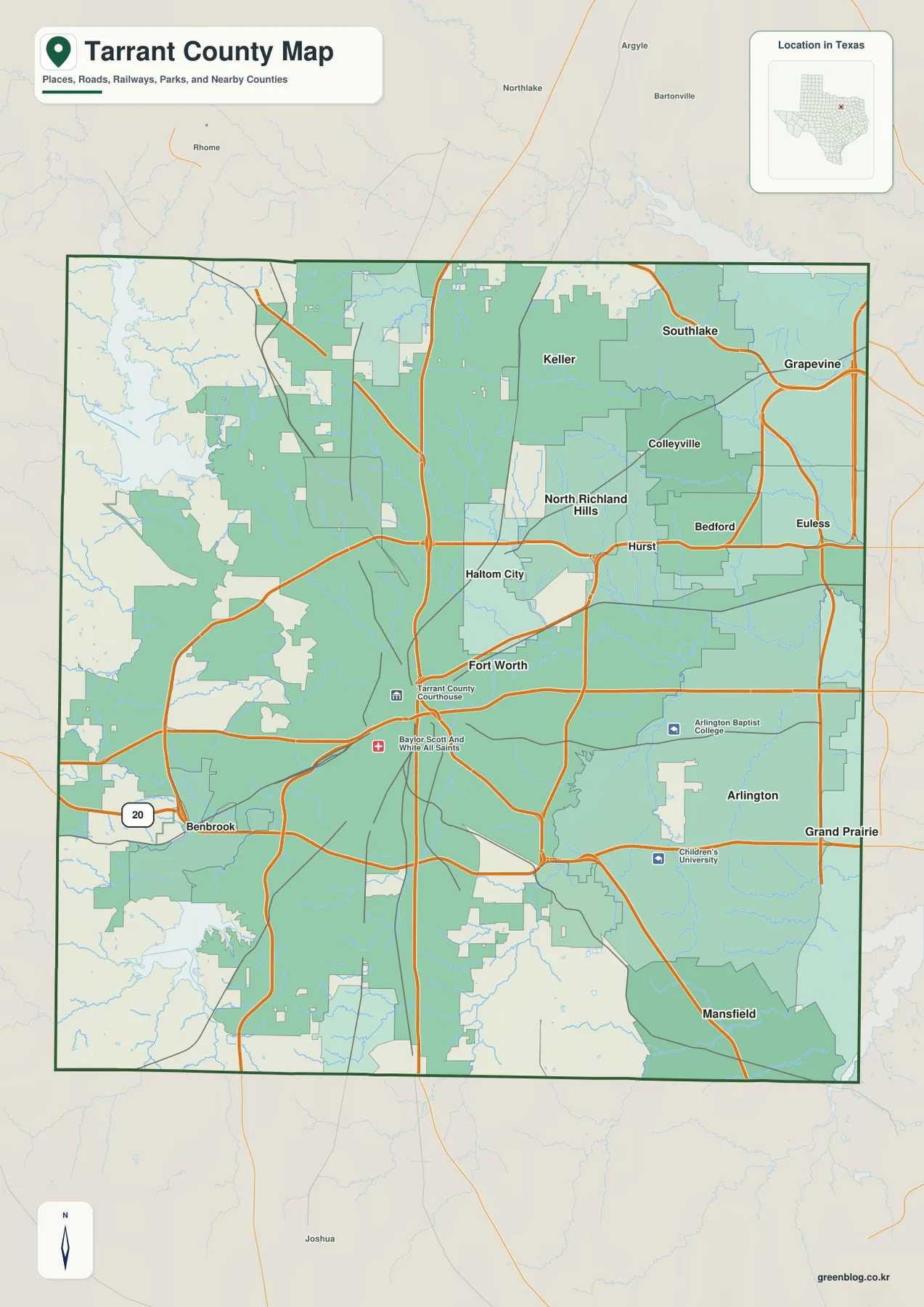
Benbrook marks the southwest side of the urban area, while Grapevine and Southlake help define the opposite northeastern corner. That wide separation is useful for understanding the county’s scale: Tarrant County is not simply Fort Worth with a ring of suburbs, but a large metropolitan county with several recognizable clusters spread across different road and water corridors.
Six ranked cities show how the population centers are distributed
The ranked city map highlights Fort Worth, Arlington, Mansfield, North Richland Hills, Euless, and Grapevine. Fort Worth is the western anchor and Arlington the eastern one. Mansfield lies near the southeastern edge, while North Richland Hills, Euless, and Grapevine create a separate concentration in the northeast. Removing most minor city labels makes those large-scale relationships much easier to see.
The CITY INDEX prints map values of 963,194 for Fort Worth, 397,742 for Arlington, 77,510 for Mansfield, 70,780 for North Richland Hills, 60,421 for Euless, and 51,139 for Grapevine. These figures explain the ranking used in the supplied graphic and should be treated as map values rather than guaranteed current population estimates. Current demographic work should use an official statistical source.
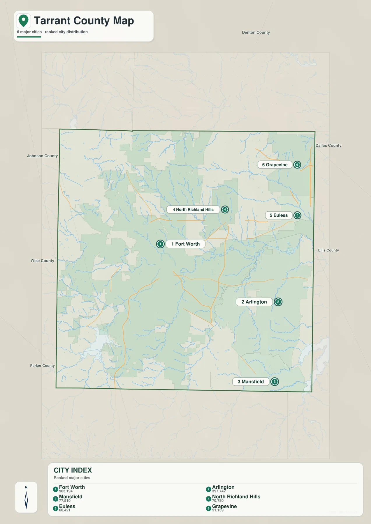
The city map also helps clarify the airport-oriented northeast described in the existing article. Grapevine and Euless sit in that direction, with North Richland Hills farther west. Mansfield, by contrast, is well south of Arlington. Those positions show that the county’s major communities are spread across several corridors rather than arranged around one compact downtown core.
Trinity River forks and reservoirs cut through the metropolitan area
The terrain-and-water map is organized around the West Fork Trinity River, which forms a long central corridor from the Lake Worth side toward the east. The Clear Fork Trinity River approaches from the southwest near Benbrook Reservoir and bends toward Fort Worth. Together, these major channels create the most important low river corridor through the central urban area.
The county’s large lakes are spread in very different directions. Eagle Mountain Lake and Lake Worth sit northwest of Fort Worth, while Grapevine Lake anchors the far northeast. Marine Creek Lake is smaller and closer to the central-northwestern urban area. Lake Arlington appears east of the central river corridor, giving Arlington a major water reference of its own.
Several named creeks help explain the lower southern and eastern terrain. Big Bear Creek crosses the northern interior toward the Grapevine side, Sycamore Creek runs through the south-central area, Village Creek continues farther east, and Walnut Creek follows the lower southern edge. These channels show that even the heavily developed parts of Tarrant County are crossed by a dense natural drainage network.
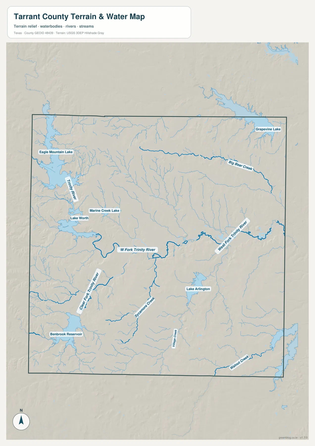
This layer is intended for geographic water reference rather than flood-risk analysis, parcel boundaries, navigation, or reservoir operations. Its most useful role here is to show how the urban road network crosses the Trinity River valleys and how the major lakes provide recognizable landmarks on the northwest, northeast, southwest, and eastern sides of the county.
Higher western terrain drops into the central Trinity corridor
The elevation map reports an actual range of about 129 to 295 meters and a mean elevation of 202 meters. The strongest brown and tan high ground is concentrated in the west and southwest, with additional rugged terrain in the northwest. The central Trinity River corridor is much greener, and broad lower terrain continues across much of the east and northeast.
The county is not a simple one-direction slope. Creek valleys cut deeply into the western hills, and smaller ridges reappear south of the central river corridor. Eastward, the low terrain becomes more continuous, but gentle divides remain between adjacent streams. Comparing the relief map with the water layer makes it clear that the West Fork and Clear Fork Trinity occupy the broadest low corridors while many smaller creeks follow narrower branches.
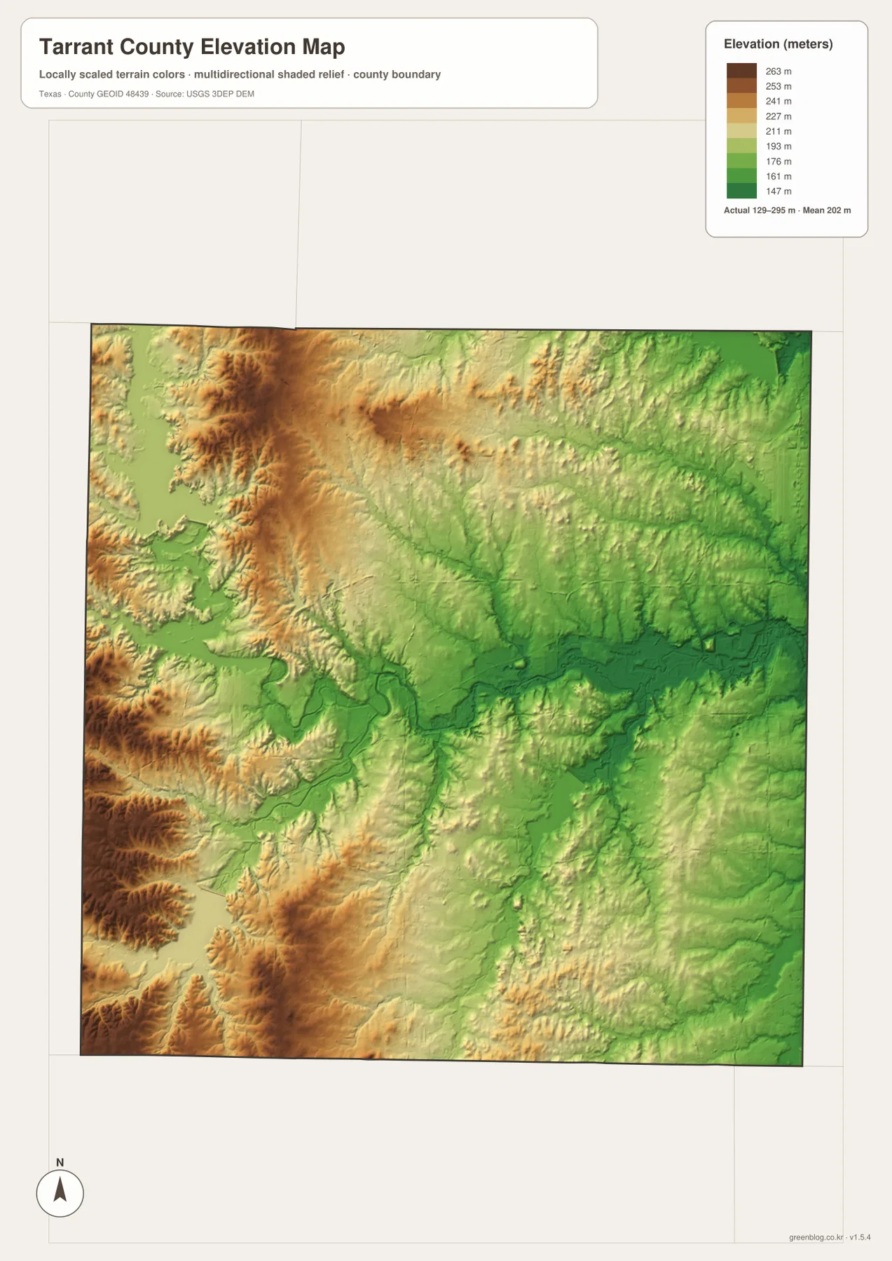
This countywide elevation surface is designed for broad terrain comparison rather than parcel surveying or engineering design. It is useful for seeing how Fort Worth’s western side rises above the river corridor, where low valleys pass through the metropolitan area, and how Arlington and the northeast relate to the broader eastern lowlands. Exact site elevation should be checked with detailed source data or a local survey.
Choose the view by whether cities, water, or relief matters most
Use the county reference map when Fort Worth, Arlington, northeast communities, Mansfield, and major road directions need to appear together. The ranked city map is cleaner for comparing the six principal mapped cities. The terrain-and-water view is the best place to trace the Trinity River forks and compare Eagle Mountain Lake, Grapevine Lake, Benbrook Reservoir, Lake Worth, and Lake Arlington, while the elevation map makes the western hills and lower central-eastern corridors easiest to compare.
The downloadable ZIP contains four separate high-resolution A3 JPG files for Tarrant County: county reference, ranked city, terrain and water, and elevation. You can inspect the WebP versions in the article first and then use the larger JPG files for printing, classroom material, presentations, or an editable local-reference document.
Frequently Asked Questions
Where are Grapevine and Euless compared with Fort Worth?
Both are northeast of Fort Worth on the supplied maps. Grapevine is close to the county’s northeastern corner, while Euless lies farther south and west within the same broad airport-side cluster.
Are Eagle Mountain Lake and Benbrook Reservoir on the same side of Fort Worth?
No. Eagle Mountain Lake lies northwest of Fort Worth, while Benbrook Reservoir is southwest. Lake Worth is also on the northwestern side, and Grapevine Lake is far to the northeast.
What elevation range is shown for Tarrant County?
The supplied elevation map states an actual range of about 129 to 295 meters and a mean elevation of 202 meters. The west and southwest are generally higher, while the Trinity River corridor and much of the east are lower.
Map File Information
The ZIP contains the four Tarrant County maps in high-resolution A3 JPG format.
- Included Versions: County reference, ranked city, terrain and water, elevation
- Included Files: 4 A3 JPG maps
Related Maps
Sources and data references
Roads, city locations, and the Tarrant County boundary can be cross-checked with the U.S. Census Bureau TIGER/Line Shapefiles. Trinity River forks, reservoirs, and named creeks can be checked against USGS National Hydrography, while terrain height data are available through the USGS 3D Elevation Program. City index values, road references, named waters, and the 129–295 meter elevation range described above are based on the Tarrant County maps and existing article material supplied in this package.
Green Map creates custom-edited map images using open geographic data sources such as geoBoundaries, Natural Earth, OpenStreetMap, and government open data.
These maps are edited visual materials, not raw data files, and are provided for education, documents, presentations, and graphic reference.