Denton County sits on the north side of the Dallas-Fort Worth region, but the county is not simply one continuous suburb. Denton anchors the north-central part of the county where Interstate 35 and U.S. 380 meet, while Lewisville, Flower Mound, The Colony, Little Elm, and other large communities form a much denser southern and southeastern belt around Lewisville Lake. The maps on this page add water and elevation to that road-and-city picture, and the matching high-resolution A3 JPG files are available together in a downloadable ZIP.
The strongest geographic contrast is between the higher, more dissected western side and the lower lake-and-river corridor that runs through the center and southeast. Ray Roberts Lake occupies the north, Lewisville Lake dominates the southeast-central area, and Elm Fork of the Trinity River connects the two systems. Major highways thread between those features rather than crossing them freely. Looking at the county, city, water, and elevation maps together makes it much easier to understand why development is concentrated in some places and why other parts of the county remain more open.
Table of Contents
Denton as the Junction of I-35 and U.S. 380
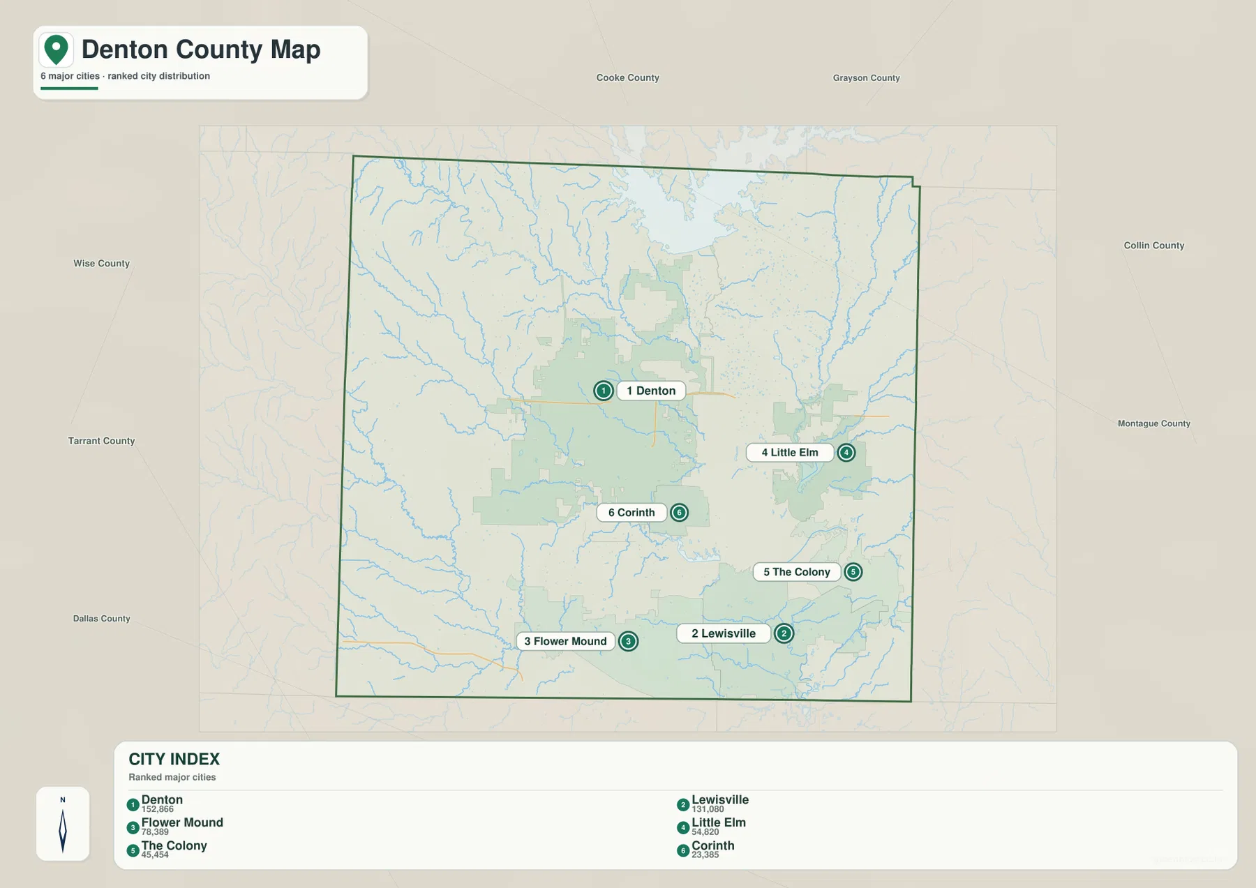
On the general county map, Denton is the most useful starting point. The city sits north of the county’s geographic center, and two major routes stand out immediately: Interstate 35 runs north-south, while U.S. 380 crosses the county from west to east. South of Denton, I-35 separates into I-35E toward Dallas and I-35W toward Fort Worth. That split is one of the clearest reasons Denton functions as a transportation hinge between the two sides of the Metroplex rather than as a city tied to only one downtown.
Other roads fill in the county’s eastern and southern connections. U.S. 377 runs through the Aubrey-Pilot Point side of the county, while State Highway 114 appears near the southern edge. The map also shows the growing network around Lewisville, Carrollton, Flower Mound, Northlake, Argyle, and Corinth. Road spacing changes noticeably outside those urbanized areas. In the west and northwest, the main routes are farther apart and the blue creek lines become more prominent, giving the landscape a much more open appearance.
U.S. 380 is especially helpful for orientation because it passes through Denton and continues toward the eastern side of the county near Little Elm and Prosper. If a reader first locates I-35 and U.S. 380, most of the other labeled places become easier to position. Sanger is north of Denton, Corinth and Argyle are south, and the large southeastern communities sit beyond the long north-south reach of Lewisville Lake.
A Southern City Cluster Wrapped Around Lewisville Lake
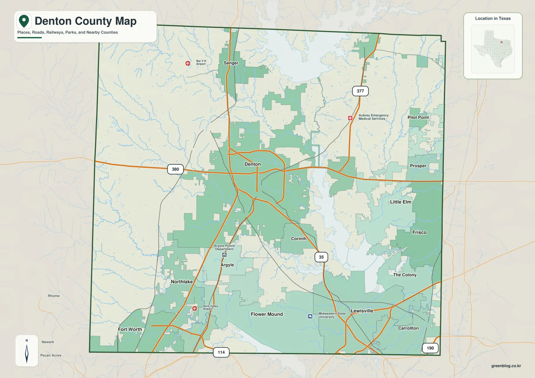
The city-index map highlights six major communities: Denton, Lewisville, Flower Mound, Little Elm, The Colony, and Corinth. Denton ranks first on the supplied index and stands apart in the north-central part of the county. The other five are clustered much farther south, creating a second major concentration rather than a simple ring around the county seat. Lewisville and Flower Mound occupy the southwest side of Lewisville Lake, The Colony lies along the southeast side, Little Elm sits near the northeastern shoreline, and Corinth occupies the corridor between Denton and Lewisville.
This arrangement makes the lake a central piece of the urban map rather than a background feature. Communities that appear close together in straight-line distance can be separated by long arms of the reservoir, narrow crossings, or limited shoreline road connections. The county map also places Frisco and Prosper along the eastern side, where Denton County meets the rapidly developed Collin County side of the region. As a result, the county’s population pattern is best described as two connected concentrations: Denton in the north-central area and a broad southern-southeastern urban belt tied more directly to the Dallas-Fort Worth metropolitan network.
The peripheral county labels around the supplied city preview are not all positioned in geographically correct directions, so they are not used as evidence here. The city locations inside Denton County, however, are consistent with the general county map and with the lake-and-road layout. This distinction matters because the internal city pattern is one of the most useful parts of the preview, while the outer labels should be checked against an authoritative boundary map before publication.
From Ray Roberts Lake to Lewisville Lake Along Elm Fork
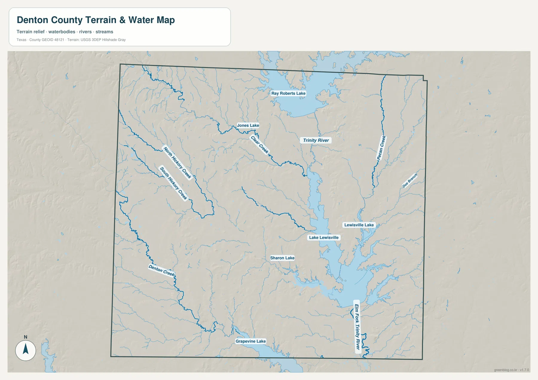
The terrain-and-water map gives Denton County a much more detailed shape than the road map. Ray Roberts Lake is the major water body in the north, while Lewisville Lake fills a large part of the southeast-central county. These reservoirs belong to the same larger drainage system. Texas Parks and Wildlife notes that the Ray Roberts Greenbelt follows the wooded banks of Elm Fork of the Trinity River for about 20 miles from the Ray Roberts Dam to Lake Lewisville. On the supplied map, that connection is visible as water moves south from Ray Roberts Lake and then continues through Lewisville Lake toward the Elm Fork Trinity River below the reservoir.
The western half of the county contains a dense network of smaller streams. Denton Creek, North Hickory Creek, and South Hickory Creek are prominent on the southwest side, while Clear Creek crosses the north-central area near Jones Lake. Pecan Creek and several unnamed tributaries cut through the eastern side. These channels occupy shallow valleys that are difficult to appreciate on a simple road map but become obvious when the blue water lines are shown over shaded terrain.
Lewisville Lake has an especially strong influence on the southern urban pattern. The U.S. Army Corps of Engineers manages Lewisville Lake as part of the Trinity Regional Project for flood-risk management, water storage, recreation, and natural resources. Its long shoreline and branching coves separate Little Elm, The Colony, Lewisville, and Flower Mound into distinct sectors even though all are part of the same rapidly developed part of the county. For anyone interested in shoreline geography, river connections, or lake access, the water map is more informative than the general county map.
Smaller water bodies add local reference points. Sharon Lake appears southwest of Lewisville Lake, Jones Lake is shown northwest of Denton, and part of Grapevine Lake is visible along the southern edge. None is as dominant as the two large reservoirs, but together they reinforce an important point: water is not confined to one corner of Denton County. Reservoirs, creeks, and river channels are woven through the county and help explain both its natural relief and its developed landscape.
Higher Western Ground and Lower Lake-River Corridors
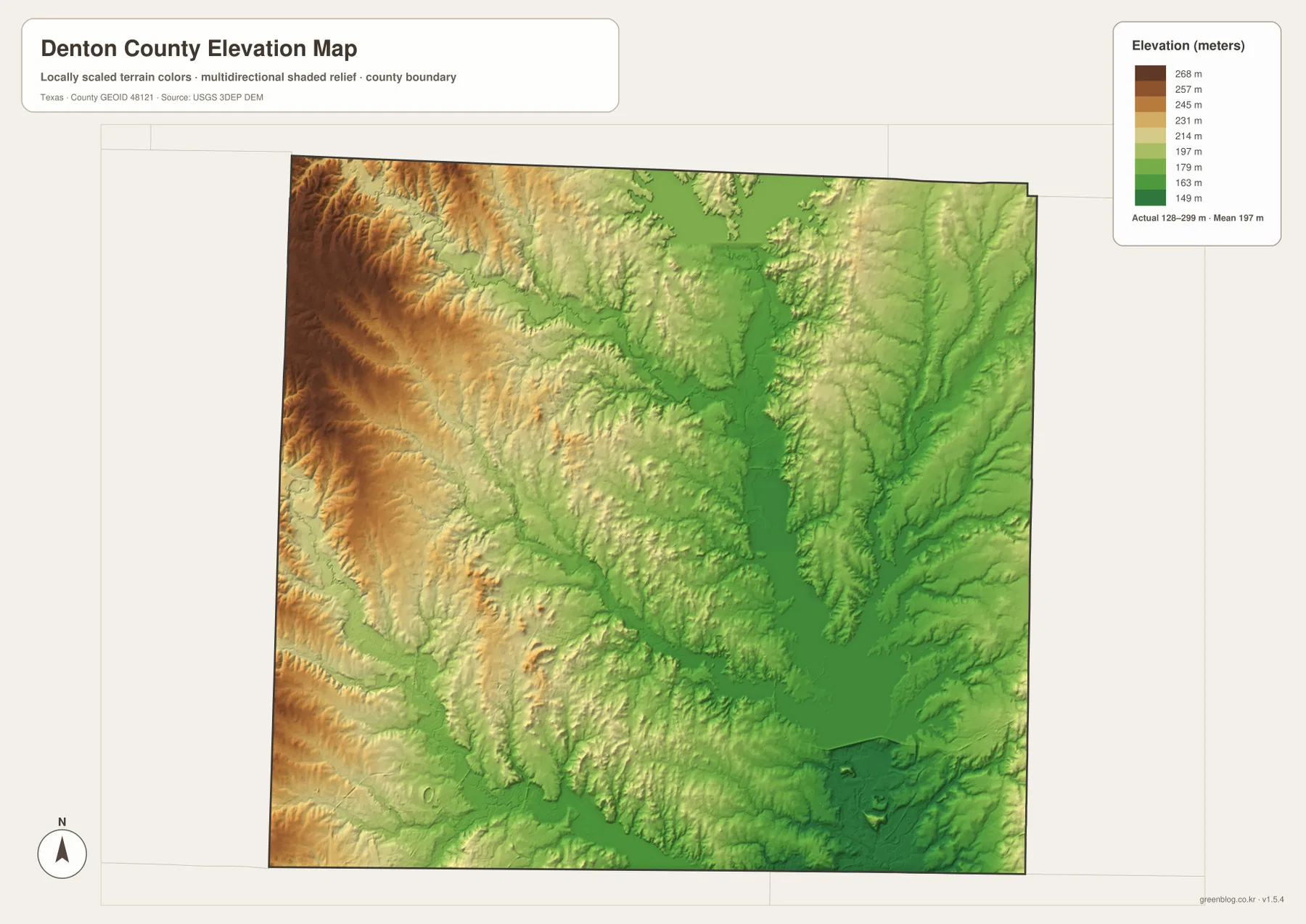
The elevation map changes the visual story again. Its legend shows an actual mapped range of roughly 128 to 299 meters, with an average near 197 meters. The highest colors are concentrated along the west and especially the northwest side of the county. Browns and golds there mark broad uplands cut by many short valleys. Moving eastward toward Denton and then southeast toward Lewisville Lake, greens become more common and the major valleys are easier to trace.
Low terrain is not limited to a single basin. Ray Roberts Lake occupies a broad low area in the north, and the Elm Fork corridor continues south through the county. Lewisville Lake sits in another prominent low zone, with tributary valleys branching outward toward developed communities. On the east side, Pecan Creek and smaller channels create narrow green corridors even where the surrounding land is somewhat higher. This is why the county looks more rugged on the elevation map than it does on a street map.
Texas Parks and Wildlife describes Ray Roberts Lake State Park as a meeting area for Eastern Cross Timbers, Blackland Prairie, and Grand Prairie. That landscape transition helps explain why the county contains both wooded creek corridors and more open uplands. The elevation map does not show mountains, but it does show enough relief to guide drainage, shape reservoir basins, and influence how roads cross the western side. The contrast is most obvious when the elevation and water maps are viewed side by side.
Choosing the Best Map for Roads, Cities, Water, or Relief
Use the general county map when the main question is how Denton, I-35, U.S. 380, U.S. 377, and the major southern communities fit together. The city map is simpler and better for comparing the six ranked communities without the distraction of every road label. The water map is the strongest choice for Ray Roberts Lake, Lewisville Lake, Elm Fork, Denton Creek, Clear Creek, and the shoreline structure. The elevation map is the clearest way to connect those water features with the higher western uplands and lower central-southeastern valleys.
For a classroom exercise, start with Denton and the I-35 split, move to the city map to compare the north-central and southern settlement clusters, and then use the water map to explain why Lewisville Lake interrupts otherwise dense development. The elevation map can finish the sequence by showing why streams and reservoirs occupy the lower parts of the landscape. For driving, boating, hiking, or park visits, these reference maps should be paired with current road, water-level, and park information from the responsible agencies.
Frequently Asked Questions
Where does I-35 split in Denton County?
Interstate 35 passes through Denton and separates south of the city into I-35E toward Dallas and I-35W toward Fort Worth. On the county map, that split is a useful reference for understanding why Denton connects directly with both sides of the Metroplex.
Are Ray Roberts Lake and Lewisville Lake connected?
Yes. They are part of the Elm Fork Trinity River system. The Ray Roberts Greenbelt follows Elm Fork from the Ray Roberts Dam toward Lake Lewisville, and water leaving Lewisville Lake continues downstream along Elm Fork of the Trinity River.
Which side of Denton County is highest on the elevation map?
The west and northwest are the highest parts on the supplied elevation map. Lower terrain follows the major creek valleys, Ray Roberts Lake, Lewisville Lake, and the Elm Fork corridor through the center and southeast.
Map File Information
The ZIP contains the Denton County general map, city map, terrain-and-water map, and elevation map as high-resolution A3 JPG files. Download the originals when you need a larger print, classroom handout, or detailed reference image.
- File Type: JPG
Related Maps
- Tarrant County Texas map
- Wise County Texas map
- Rockwall County Texas map
- Rains County Texas map
- Van Zandt County Texas map
Sources and References
The county-specific descriptions were checked against the supplied map previews and the following official geographic and public-agency sources.
- Denton County, Texas – Official Website
- U.S. Army Corps of Engineers – Lewisville Lake
- Texas Parks & Wildlife – Ray Roberts Lake State Park
- USGS National Hydrography
- USGS 3D Elevation Program
- U.S. Census Bureau TIGER/Line Shapefiles
Green Map creates custom-edited map images using open geographic data sources such as geoBoundaries, Natural Earth, OpenStreetMap, and government open data.
These maps are edited visual materials, not raw data files, and are provided for education, documents, presentations, and graphic reference.