This page uses Decatur as the central reference for a Wise County Texas Map, then follows the road network west toward Bridgeport and Lake Bridgeport and southeast toward Rhome, Aurora, and New Fairview. Download the high-resolution A3 JPG map ZIP from the box below when you need printable or editable files; it contains separate county-reference, ranked-city, terrain-and-water, and elevation maps.
Wise County has two very different geographic faces on this map set. Decatur and Bridgeport form the clearest central-western pair, with Lake Bridgeport providing a large water landmark farther west. The southeast contains a tighter group of communities including Rhome, Aurora, and New Fairview. Beneath the settlement pattern, the terrain is strongly broken by creeks and ridges: high ground appears in the northwest, southwest, and parts of the east, while broad lower valleys cross the center and southeast.
Table of Contents
Decatur connects the Bridgeport corridor with the southeastern towns
Decatur is the easiest place to locate first on the county reference map. Route 287 approaches from the northwest, passes through the Decatur area, and continues southeast toward the denser group of communities near the lower-right side of the county. Route 380 provides the main east-west reference between Bridgeport and Decatur, so those two roads establish the county’s basic orientation very quickly.
Bridgeport lies west of Decatur, and Runaway Bay sits farther west beside Lake Bridgeport. Southeast of Bridgeport, route 51 and route 114 help lead toward Boyd and Aurora. Rhome and New Fairview lie close to the route 287 direction farther southeast. This produces a visible contrast between the road-and-settlement concentration near the southeastern side and the more sparsely labeled north and southwest.
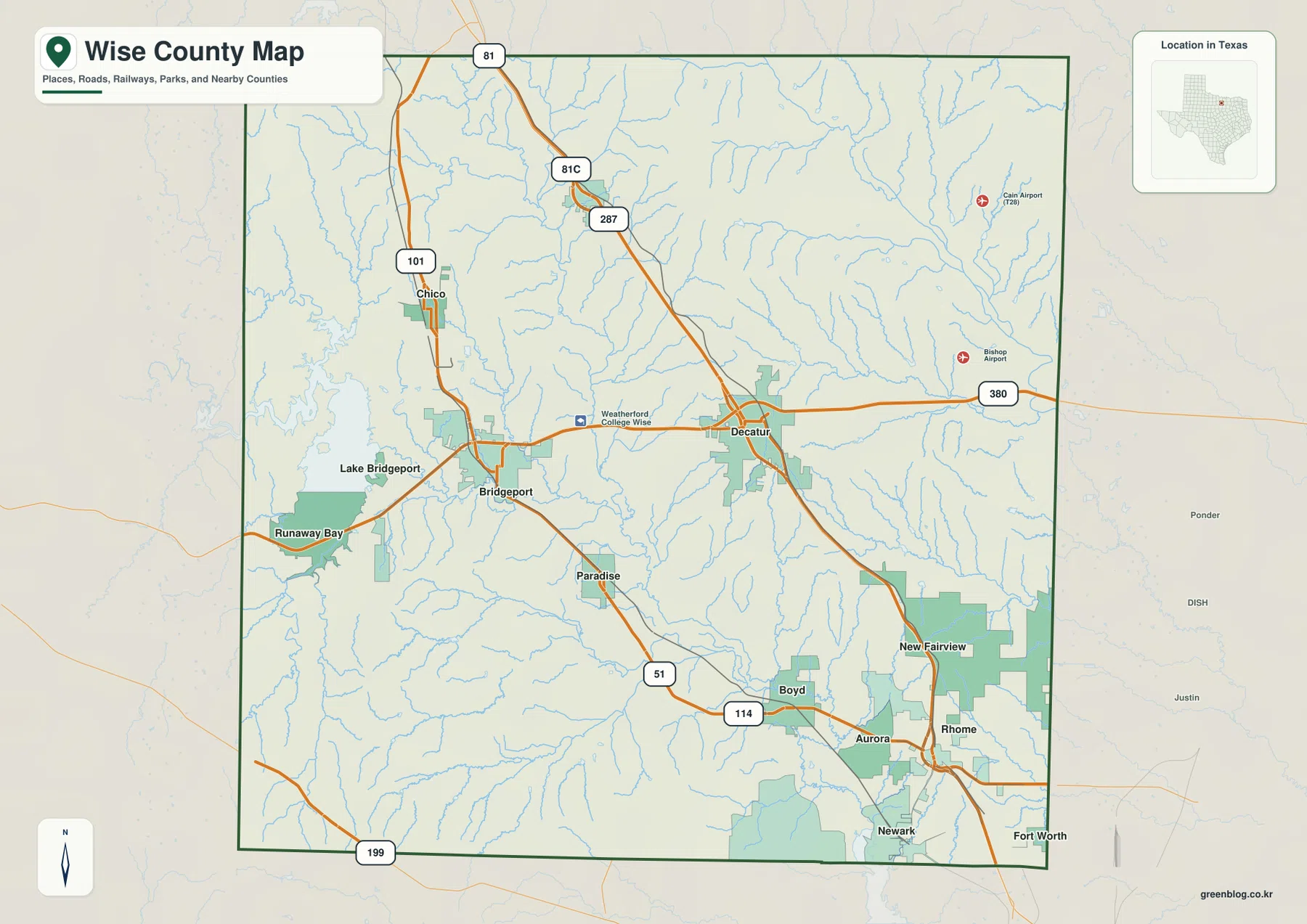
Chico appears in the northwest near route 101, while route shields 81, 81C, and 287 provide additional references north of Decatur. Route 199 crosses the southwestern edge, where city labels are sparse and streams become more useful for orientation. The full map therefore works best when Decatur and Bridgeport are used as the first anchors, followed by the southeastern town cluster and the open creek-cut country around them.
Decatur and Bridgeport lead a six-city ranking split between west and southeast
The ranked-city layer highlights Decatur, Bridgeport, Aurora, Runaway Bay, Rhome, and New Fairview. Decatur is number 1 near the center-east and Bridgeport is number 2 in the west. Aurora ranks third in the southeast, Runaway Bay is fourth beside the Lake Bridgeport side, Rhome is fifth, and New Fairview is sixth near the southeastern edge.
The CITY INDEX prints map values of 7,426 for Decatur, 6,331 for Bridgeport, 1,760 for Aurora, 1,717 for Runaway Bay, 1,699 for Rhome, and 1,570 for New Fairview. These figures explain the ranking and relative symbol display used in the supplied graphic and should not be treated as guaranteed current population estimates. For geographic reading, the more useful pattern is the division between two larger central-western cities, one lake-side community, and a cluster of smaller southeastern places.
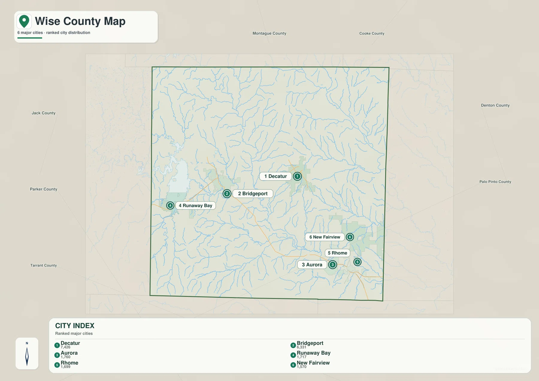
Neighboring counties add a useful regional frame. Montague and Cooke counties are to the north, Denton County lies east, Jack County is west, and Parker and Tarrant counties are on the southern and southeastern sides. That frame makes the southeast-facing position of Rhome and New Fairview clearer and shows why Bridgeport and Runaway Bay belong to a distinctly western part of the county.
Lake Bridgeport feeds into a wider West Fork Trinity River and creek network
Lake Bridgeport is the largest western water landmark on the county reference map. On the terrain-and-water layer, the drainage leaving the lake connects toward the West Fork Trinity River system. Dry Creek, Garrett Creek, Salt Creek, and Willow Creek provide additional named valleys on the western and southern side, showing that the lake sits inside a much larger network of creek-cut terrain.
Big Sandy Creek is a strong northern drainage reference, while Elm Branch runs south through the north-central interior. In the northeast, Denton Creek follows a broad winding valley and Black Creek joins the same general system. Catlett Creek lies farther south on the eastern side. These waterways cut across ridges that are especially visible on the elevation layer.
The West Fork Trinity River is most prominent across the south-central part of the water map, with Walnut Creek descending nearby. Oliver Creek and Elna Reservoir provide eastern references, and Eagle Mountain Lake is visible just beyond the southeastern county boundary. Wise County is therefore better understood as a combination of Lake Bridgeport, the West Fork Trinity River, and many named creeks rather than as a county organized around one isolated lake.
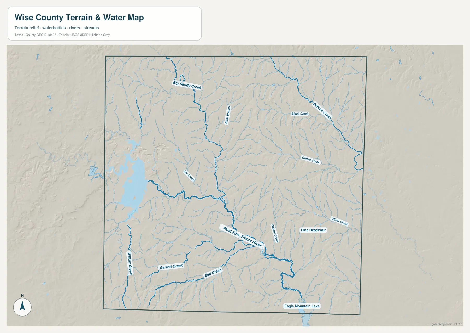
This layer is intended for geographic water and terrain reference rather than flood-risk analysis, navigation, water depth, parcel boundaries, or reservoir-management decisions. Its main value here is to show how the Lake Bridgeport side connects into the western drainage network, how Denton Creek crosses the northeast, and how the West Fork Trinity River occupies lower ground farther south.
Elevation ranges from 198 to 382 meters across ridges and river valleys
The elevation map reports an actual range of about 198 to 382 meters and a mean elevation of 269 meters. High brown terrain is especially strong along the northwest and southwest edges, with another set of pronounced ridges in the east-central part of the county. Broad green lower terrain crosses much of the center and southeast, following the major drainage corridors.
The Lake Bridgeport area combines a low basin around the water with higher terrain around its margins. Moving toward the center, long green valleys divide the higher northwest and southwest ridges. Eastern Wise County also contains elevated ridges rather than one flat plain, but Denton Creek and nearby tributaries cut lower passages through them. The county therefore does not descend in one simple direction; it alternates between uplands and creek valleys.
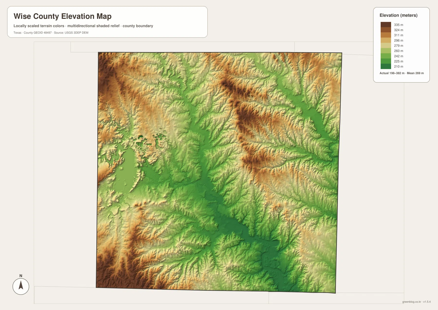
This countywide elevation surface is designed for broad terrain comparison rather than parcel surveying, engineering, or construction design. It is useful for seeing why the northwest and southwest stand higher, how Lake Bridgeport occupies lower terrain, and where the West Fork Trinity River and other creeks follow valleys. Exact site elevation should be checked with detailed source data or a local survey.
Choose the layer by whether roads, city ranking, lake country, or relief matters most
Use the county reference map when Decatur, Bridgeport, Rhome, Aurora, New Fairview, road labels, and Lake Bridgeport need to appear together. The ranked-city view is cleaner for comparing the six major mapped places. The terrain-and-water layer is the best place to trace the West Fork Trinity River, Denton Creek, Big Sandy Creek, and named reservoirs, while the elevation map makes the high outer ridges and lower central valleys easiest to compare.
The downloadable ZIP contains four separate high-resolution A3 JPG files for Wise County: county reference, ranked city, terrain and water, and elevation. You can inspect the lighter WebP versions in the article first and then use the larger JPG files for printing, classroom material, presentations, or an editable local-reference document.
Frequently Asked Questions
Where are Rhome and New Fairview compared with Decatur?
Rhome and New Fairview are southeast of Decatur on the supplied maps. Route 287 provides the clearest road reference between Decatur and the southeastern side of the county.
Where is Lake Bridgeport within Wise County?
Lake Bridgeport is in western Wise County, beside the Bridgeport and Runaway Bay area. The terrain-and-water map shows its connection with the wider West Fork Trinity River and creek network.
What elevation range is shown for Wise County?
The supplied elevation map states an actual range of about 198 to 382 meters and a mean elevation of 269 meters. The northwest, southwest, and some eastern ridges are higher, while central and southeastern drainage valleys are lower.
Map File Information
The ZIP contains the four Wise County maps in high-resolution A3 JPG format.
- Included Versions: County reference, ranked city, terrain and water, elevation
- Included Files: 4 A3 JPG maps
Related Maps
Sources and data references
Roads, settlement locations, and the Wise County boundary can be cross-checked with the U.S. Census Bureau TIGER/Line Shapefiles. West Fork Trinity River, Denton Creek, reservoirs, and other named water features can be checked against USGS National Hydrography, while terrain height data are available through the USGS 3D Elevation Program. City index values, route references, named waters, and the 198–382 meter elevation range described above are based on the Wise County maps supplied in this package.
Green Map creates custom-edited map images using open geographic data sources such as geoBoundaries, Natural Earth, OpenStreetMap, and government open data.
These maps are edited visual materials, not raw data files, and are provided for education, documents, presentations, and graphic reference.