You can download four high-resolution A3 JPG maps of Lake County, South Dakota, as one ZIP from this page. The maps cover the county and road layout, straight-line community connections from Madison, lakes and waterways, and countywide elevation. Madison is the most practical place to begin because it sits just south of the county’s middle, with Lake Herman to the west and Lake Madison to the southeast. Using those three landmarks first makes the smaller communities and water features much easier to place.
Lake County is not simply a county with two prominent lakes. Ramona lies northwest of Madison, Nunda northeast, Wentworth east, and Brant Lake southeast. North of those communities, Lake Badus, Mud Lake, and a broad bend of Battle Creek add another group of water features, while the East Fork Vermillion River runs along the western side. The southeast has its own network of creeks around the lake country. These patterns become clearer when the general, water, and elevation maps are read together rather than as separate illustrations.
The elevation legend shows actual values from roughly 472 to 572 meters, with a mean near 522 meters. Higher terrain is more common in the west and northwest, and lower green shades expand toward the eastern and southeastern lakes. That difference is modest compared with mountainous counties, but it is large enough to give Lake County a visible west-to-east change in relief. The map is useful for regional comparison, not for surveying an individual parcel.
Table of Contents
Start with Madison, Lake Herman, and Lake Madison
The general county map makes Madison the clearest anchor. The city is shown as the largest settlement area, and Route 34 provides an obvious east-west reference through the southern half of the county. Wentworth is east of Madison, while Brant Lake lies farther southeast among several water bodies. Ramona is northwest and Nunda northeast, so the communities do not form a single corridor or cluster around one side of the county.
Lake Herman and Lake Madison create a second pair of landmarks. Lake Herman sits west of Madison and is compact enough to recognize quickly. Lake Madison lies southeast of the city and has a longer shape, so the two lakes are easy to distinguish once their directions are known. If you first locate Madison, then the western lake, then the southeastern lake, the rest of the map becomes easier to organize. Roads, smaller communities, and the county boundary can all be related back to those fixed points.
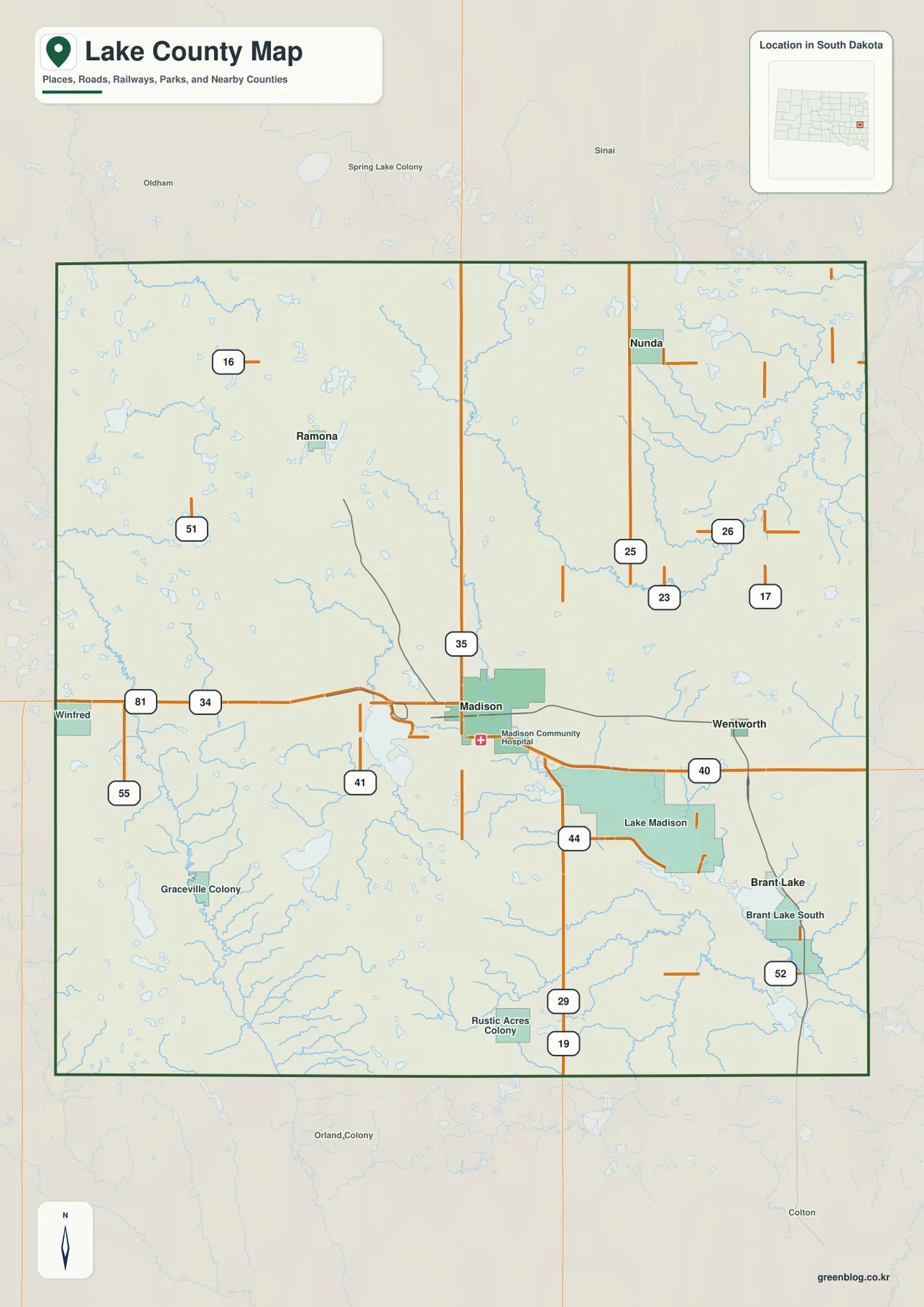
The outline is fairly simple, but the settlement pattern makes the county feel broader than a Madison-centered view suggests. Ramona reaches into the northwest, Nunda marks the northeast, and Brant Lake sits in the southeast. Tracing the county border before returning to Madison is a useful way to see how much rural land lies between the communities.
Straight lines from Madison show direction, not driving routes
The community-connections map uses Madison as the hub and draws direct lines to four labeled places. Ramona is about 9 miles northwest, Nunda about 12 miles northeast, Wentworth about 8 miles east, and Brant Lake about 10 miles southeast. These values are straight-line distances between mapped points. They are not road mileage, travel time, or recommended routes, and a real drive may be longer because local roads and lake shorelines do not follow those direct lines.
The map is most helpful when distance and direction are read together. Wentworth is the shortest labeled connection, but it lies almost due east of Madison. Ramona and Brant Lake are similar in straight-line range while sitting on very different sides of the city. Nunda extends farthest toward the northeast. That comparison gives a quick sense of the county’s populated spread before the general map is used to trace actual roads.
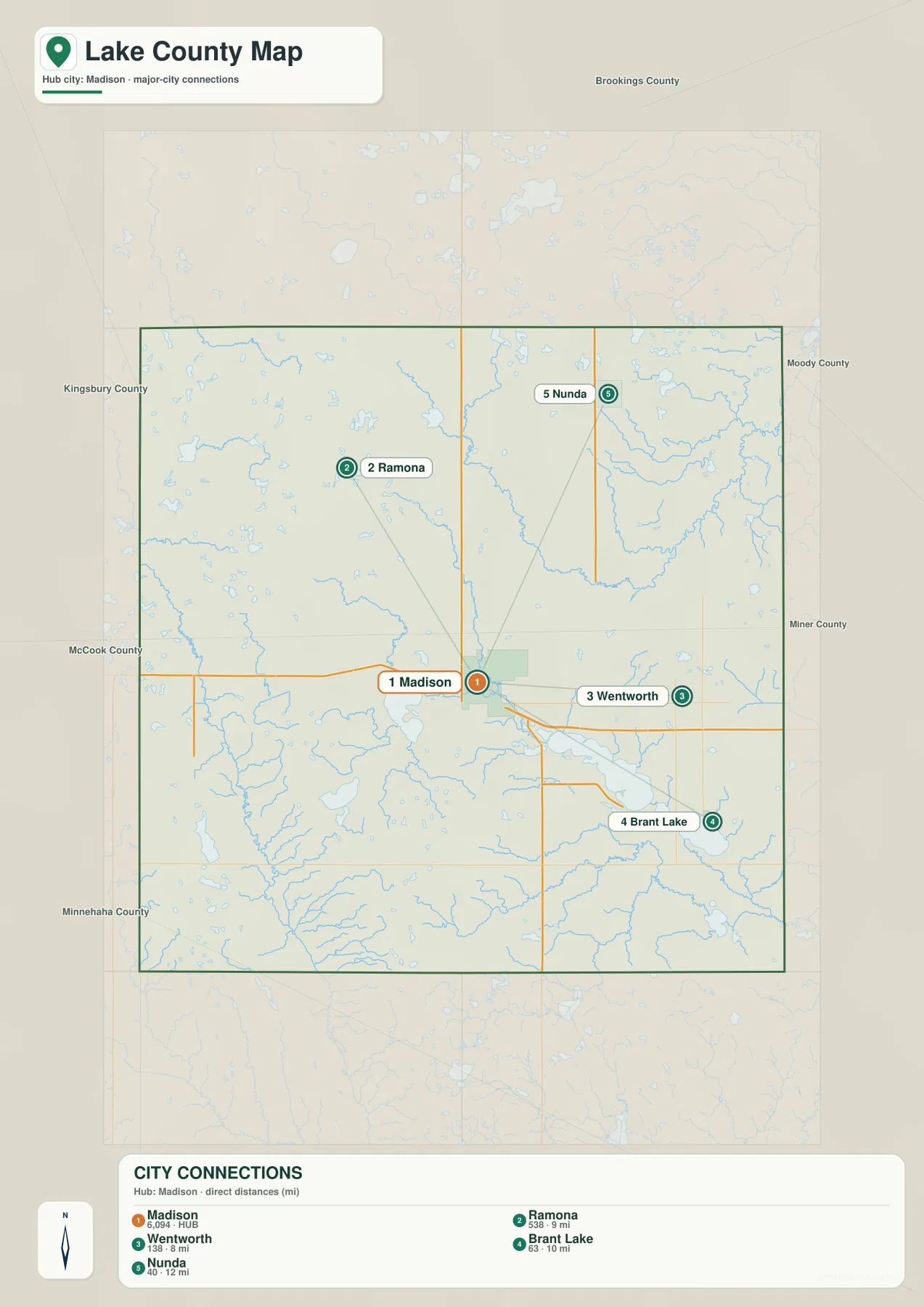
This distinction matters especially around the lakes. A destination that appears close in a straight line may require a longer road approach if the local road grid bends around water or fields. Use the connection map to answer “where is it from Madison?” and the general map or a current road service to answer “how do I drive there?”
The water network reaches well beyond the two best-known lakes
Lake Herman and Lake Madison are the easiest water bodies to recognize, but they are only part of the county’s water pattern. East of Lake Madison are Long Lake, Round Lake, and Brant Lake, while Lake Badus and Mud Lake occupy the northern part of the county. Their different sizes and positions show why the water map is useful even for readers who already know the two large lakes near Madison.
The streams add a second layer. Battle Creek makes a broad bend in the north, and the East Fork Vermillion River follows the western side. In the southeast, North Buffalo Creek, Buffalo Creek, Franklin Creek, and Skunk Creek appear in separate parts of the lake country. Lake County therefore does not have one dominant river crossing the entire county. Instead, lakes and smaller channels are distributed across several parts of the landscape.
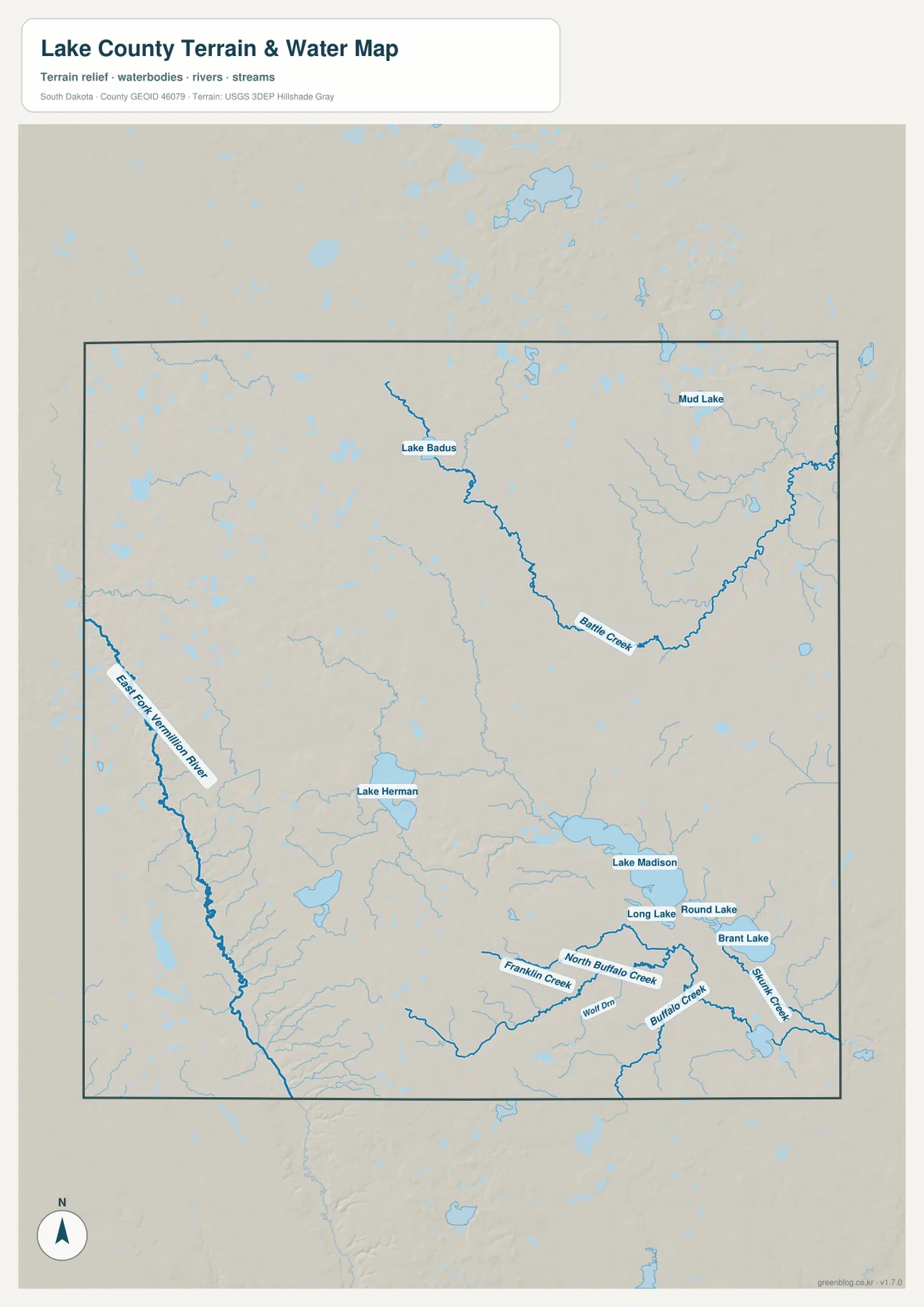
This is a location reference, not a flood, depth, water-quality, or navigation chart. A blue line indicates a mapped water feature rather than current flow conditions or legal shoreline limits. For current hydrography or more detailed water data, consult the original USGS National Hydrography resources.
Higher western ground gives way to the eastern lake country
The elevation map shows a broad west-to-east contrast. Brown and tan shades are more common in the west and northwest, while greens become more extensive around Madison and toward Lake Madison and the eastern lakes. The legend reports actual elevations of about 472 to 572 meters, with an average near 522 meters. A range of roughly 100 meters may seem small, but it is enough to distinguish upland areas from lower lake and creek settings.
The county is not a smooth ramp from west to east. Lower draws cut into some western areas, and locally higher ground appears again in the south-central and outer parts of the county. Even so, the overall pattern remains clear: the western and northwestern side is generally higher, while much of the eastern lake country is lower. Comparing the elevation map with the water map helps connect those colors to Lake Madison, Brant Lake, and the creek network.
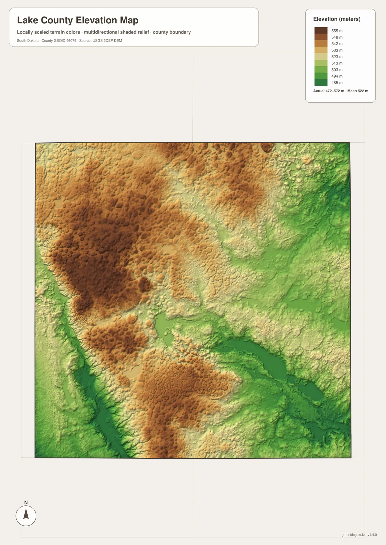
The shaded surface is intended for county-scale comparison. It should not be used as a survey or as an exact elevation for a house, parcel, road point, or construction site. Precise work requires the underlying elevation data or a professional survey.
Use the same landmarks as you move from one map to the next
If roads and communities are your main interest, begin with Madison on the general map, then follow Route 34 and the directions toward Ramona, Nunda, Wentworth, and Brant Lake. Move to the connection map next to compare those places by direction and straight-line separation. Keeping Madison fixed as the reference point prevents the county from feeling like four unrelated map views.
For water, start with Lake Herman and Lake Madison and then expand outward to Lake Badus, Battle Creek, the East Fork Vermillion River, and the southeastern creeks. On the elevation map, find those same areas again to see how the western uplands differ from the lower eastern lake country. This cross-checking method is more useful than treating each map as a separate product because the roads, communities, water, and relief all describe the same county.
The WebP images in the article are optimized for browsing. The ZIP below contains the larger A3 JPG originals, each 2572×3638 pixels, for printing, classroom material, presentations, or offline reference. Printer margins and final physical size can vary, so check the print preview before producing a full-size copy.
Frequently Asked Questions
Are the Madison-to-Ramona, Nunda, Wentworth, and Brant Lake numbers driving distances?
No. The map uses straight-line distances of about 9 miles to Ramona, 12 to Nunda, 8 to Wentworth, and 10 to Brant Lake. Driving mileage can be longer because actual roads follow the rural grid and may bend around lakes or other features.
Does the water map include features beyond Lake Herman and Lake Madison?
Yes. It also shows features such as Lake Badus, Mud Lake, Battle Creek, the East Fork Vermillion River, and several creeks in the southeast. Those additional features make the water map useful for understanding the county beyond the two largest familiar lakes.
Can I use the 472–572 m elevation range as an exact parcel elevation?
No. The legend summarizes actual county elevations, but the map is designed for regional comparison. A precise property, engineering, or construction elevation requires the original elevation dataset or a professional survey.
Map File Information
The ZIP contains four high-resolution A3 JPG files: the county map, community-connections map, terrain-and-water map, and elevation map.
- Printable Size: 2572×3638 pixels each
- File Type: ZIP containing 4 JPG files
Related Maps
Sources and references
- Lake County Auditor – official county administrative and contact information in Madison.
- South Dakota Game, Fish and Parks – Lake Herman State Park – official information about Lake Herman and its park setting.
- U.S. Census Bureau TIGER/Line Shapefiles – official boundary, road, and place reference data.
- USGS National Hydrography – official U.S. water-feature data for rivers, streams, and lakes.
- USGS 3D Elevation Program – official elevation data and program information.
Green Map creates custom-edited map images using open geographic data sources such as geoBoundaries, Natural Earth, OpenStreetMap, and government open data.
These maps are edited visual materials, not raw data files, and are provided for education, documents, presentations, and graphic reference.