Wilkes County sits in the foothills south of the Blue Ridge, and its map makes the most sense when Wilkesboro and North Wilkesboro are treated as two close but separate central towns. W. Kerr Scott Reservoir defines the western side, rugged ridges become stronger toward the west and northwest, and the Yadkin River continues east toward smaller places such as Ronda. Millers Creek, Mulberry, Hays, and other local labels help show how quickly the landscape changes once the map leaves the paired urban center.
The page starts with the general road-and-place map, then uses the city-connections graphic to compare North Wilkesboro, Wilkesboro, and Ronda, and finally turns to the terrain-and-water view for Yadkin River, W. Kerr Scott Reservoir, Reddies River, the Roaring River branches, and smaller mountain streams. The WebP previews are meant for quick browsing, while the map file box below provides the three matching high-resolution A3 JPG files in one ZIP.
Table of Contents
Wilkes County quick facts from the supplied maps
- County seat: Wilkesboro
- Paired central towns: Wilkesboro and North Wilkesboro
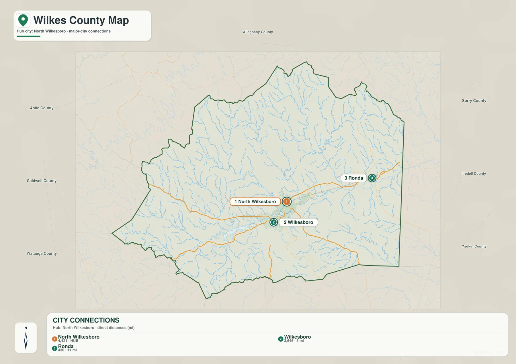
- City-connections hub: North Wilkesboro 4,421
- Other city-map values: Wilkesboro 3,646 at about 3 miles; Ronda 436 at about 11 miles
- Additional general-map references include Millers Creek, Cricket, Fairplains, Mulberry, Hays, Moravian Falls, and Ronda
- Major road labels include 421, 268, 115, 16, 18, and 21
- Major water references include Yadkin River, W. Kerr Scott Reservoir, Reddies River, Roaring River branches, and Lewis Fork branches
The existing Wilkes County Growth Management Plan describes the county as lying in the foothills south of the Blue Ridge and identifies Yadkin River as an important geographic feature crossing the county. The current page also uses W. Kerr Scott Reservoir as a major western water reference. Those source-backed points remain useful context, while the detailed discussion below stays with the places, roads, streams, and terrain visible in the supplied package.
Two Wilkesboros form the central county reference
Wilkesboro and North Wilkesboro sit very close together around the Yadkin River corridor. North Wilkesboro Police Department is labeled within the northern town, while Wilkesboro lies just south where route 421 and several local roads converge. The short separation can make the pair look like one city at first glance, but keeping both names matters because the county seat and the northern town are distinct places.
West of the paired towns, Millers Creek and Cricket provide smaller foothill references. Mulberry and Hays appear farther north, where routes 16 and 18 help organize travel through more rugged terrain. The road-and-place map therefore shows a clear transition from a relatively concentrated central settlement area to a landscape where creek valleys and mountain roads become more important.
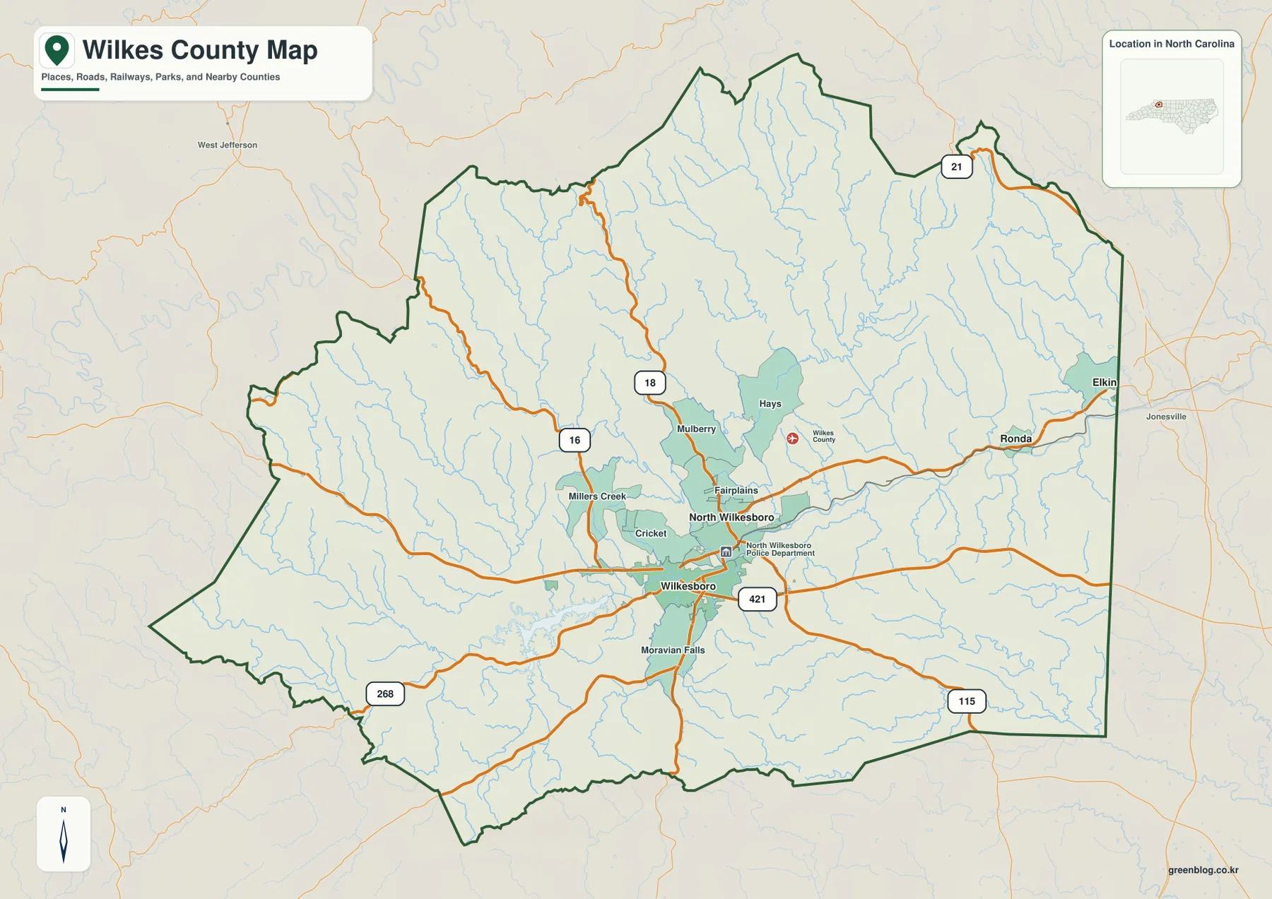
East of the center, Fairplains leads toward Ronda, with Elkin visible outside the county as regional context. Ronda is much smaller than the two Wilkesboro towns, yet it provides a useful eastern reference along the broader Yadkin direction. That makes the outer county easier to describe without pretending that every eastern valley is simply part of the central urban area.
Moravian Falls appears south of Wilkesboro, while routes 268 and 115 help separate southwestern and southeastern directions. The southern interior is still hilly, but it has a different pattern from the more rugged western and northwestern edge. Reading these place labels with the road network gives the general map more meaning than a simple county outline alone.
Yadkin River and Kerr Scott Reservoir separate east-west settings
Yadkin River is the strongest large-river reference in the terrain map. It crosses the central county and continues east, providing a physical frame for the Wilkesboro–North Wilkesboro area and the valleys beyond. The road map emphasizes towns and highways; the water map reveals that the same central area is also a meeting place for a large river and several major tributaries.
W. Kerr Scott Reservoir lies west of the central towns and forms the most prominent open-water feature inside the county. Its elongated water body reaches into the surrounding foothills and gives the western side a clear physical anchor. Using the reservoir together with the Yadkin makes it easier to distinguish western lake-and-ridge country from the eastward river corridor.
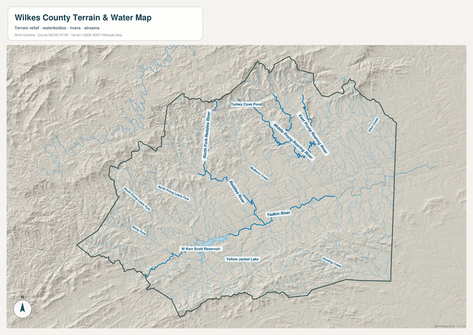
North of the central corridor, Reddies River runs through a long valley and North Fork Reddies River occupies a separate branch farther west. Middle Prong Roaring River and East Prong Roaring River descend from the north-central mountains, with Mulberry Creek adding another local water reference. These channels show why the northern county is better understood as a set of separate mountain valleys than as one broad upland.
The western map also labels North Prong Lewis Fork, South Prong Lewis Fork, and Short Fork, while Turkey Cove Pond appears farther north. Elk Creek is visible near the eastern edge, Hunting Creek in the southeast, and Yellow Jacket Lake near the south-central interior. These smaller waters are useful local markers, but they should not be treated as features comparable in scale to Yadkin River or W. Kerr Scott Reservoir.
Northwestern foothills differ from the eastern Yadkin valley
Relief shading is rugged across much of Wilkes County, with the strongest concentration of closely spaced ridges and narrow valleys toward the west and northwest. The terrain continues into even rougher country beyond the western boundary toward the High Country. The eastern side remains hilly, but the Yadkin and its tributaries create longer, more open valley corridors than the western mountain edge.
The same contrast appears on the general map. Millers Creek and the western road network are useful foothill references, while Ronda and the Yadkin direction help organize the east. Wilkesboro and North Wilkesboro sit between these settings, which makes the paired center a meeting point rather than a perfect model for every part of the county.
The Growth Management Plan’s Blue Ridge foothill description fits this visible terrain, but the shaded background is not a survey-grade elevation model for direct measurement. It is appropriate for recognizing relative ridge-and-valley differences and broad high-relief areas; exact elevations, slopes, or engineering decisions require the underlying official elevation data.
Use the paired towns, reservoir, and foothills together
The city-connections graphic uses North Wilkesboro as the hub. Its lower panel lists North Wilkesboro at 4,421, Wilkesboro at 3,646, and Ronda at 436. These figures are the values printed on the supplied Wilkes County graphic and are not replaced here with a separate current-population series.
Wilkesboro is shown about 3 straight-line miles from North Wilkesboro, while Ronda is about 11 miles away. Those connectors are not driving routes or road mileage. Wilkesboro is the nearby southern partner in the central town pair, whereas Ronda sits much farther east along a different river-and-road setting, so the general map remains necessary for travel orientation.
A practical reading order starts with the two Wilkesboro towns, then expands west to W. Kerr Scott Reservoir and Millers Creek, north to the Reddies and Roaring River valleys, and east toward Ronda and the Yadkin corridor. This sequence keeps municipal importance, settlement size, water geography, and mountain relief separate enough to remain useful while still showing how they fit together.
The download archive contains three high-resolution A3 JPG files matching the Wilkes County general map, city-connections map, and terrain-and-water map. The WebP previews keep the page easy to browse, while the JPG originals retain more detail for printing, enlargement, and document placement, especially around reservoir shoreline, small creek labels, and rugged relief.
For Wilkes County, this downloadable set is intended for broad place, road, stream, and foothill orientation. Legal boundaries, surveying, flood determinations, water depth, navigation, and engineering-grade elevation work should rely on the relevant official Census, USGS, county, or other authoritative source data.
Frequently Asked Questions
Why should Yadkin River and Kerr Scott Reservoir be read together?
Yadkin River provides the major central-to-eastern valley reference, while W. Kerr Scott Reservoir anchors the western foothills. Using both makes the contrast between the central town pair, western lake country, and eastern river corridor much easier to see.
Why keep North Wilkesboro separate from Wilkesboro on the map?
Wilkesboro is the county seat and North Wilkesboro is a separate town immediately to the north and the hub used by the supplied city-connections graphic. Keeping both names visible preserves the actual municipal relationship and makes the surrounding roads and river corridor easier to orient.
Map File Information
The ZIP contains three high-resolution A3 JPG files matching the Wilkes County general map, city-connections map, and terrain-and-water map shown on this page.
- Included Files: Three high-resolution A3 JPG maps: general county map, city-connections map, and terrain-and-water map
- File Type: High-resolution A3 JPG files in one ZIP archive
- Intended Use: Printing, education, presentations, and map-based projects
Related Maps
- Across the Rowan County North Carolina Map
- Across the Surry County North Carolina Map
- Alamance County Map
Sources
- Wilkes County Growth Management Plan
- U.S. Census Bureau – TIGER/Line Shapefiles
- USGS – National Hydrography
- USGS – 3D Elevation Program
The county plan provides local growth and foothill context, while Census and USGS links support boundary, hydrography, and elevation-reference checks. City values, straight-line distances, road labels, Yadkin River, W. Kerr Scott Reservoir, Reddies River, Roaring River branches, and smaller water labels described above are grounded in the supplied Wilkes County package.
Green Map creates custom-edited map images using open geographic data sources such as geoBoundaries, Natural Earth, OpenStreetMap, and government open data. These maps are edited visual materials, not raw data files, and are provided for education, documents, presentations, and graphic reference.