Download high-resolution A3 JPG maps of Gillespie County, Texas from the ZIP box on this page, including the county, city, water, and elevation views shown below. Fredericksburg is the main settlement and road reference, with Harper to the west and Stonewall to the east along the U.S. 290 corridor. The terrain maps add the feature that most strongly shapes the county: a dense network of creeks and valleys feeding the Pedernales River, with higher ground spread across much of the west and central interior and lower terrain expanding toward the east. The supplied elevation map ranges from about 317 to 692 meters, making the relief difference visible even at county scale.
Fredericksburg is the easiest place to begin. U.S. 290 crosses the county from the Harper side through Fredericksburg toward Stonewall, while U.S. 87 provides a strong north-south reference at the city. Highway 16 approaches from the southwest, and another major road descends toward Fredericksburg from the north. The road pattern looks fairly simple around the central town, but the stream network underneath it is highly branched, especially across the western uplands and eastern creek country.
Table of Contents
Fredericksburg Between Harper and Stonewall
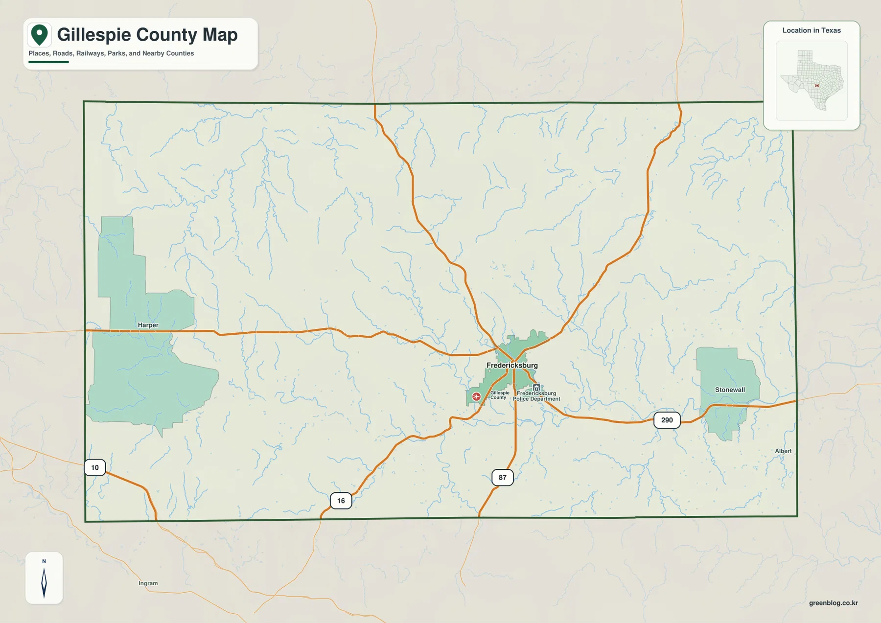
The general county map makes Fredericksburg the clearest transportation anchor. U.S. 290 approaches from Harper in the west, crosses Fredericksburg, and continues toward Stonewall in the east. U.S. 87 runs south from Fredericksburg and aligns with a major northbound route through the upper half of the county. Highway 16 approaches the city from the southwest. Together, these roads provide a practical framework for locating communities before the much denser network of local roads and streams is considered.
Harper sits well west of Fredericksburg along the U.S. 290 direction, while Stonewall is much closer to the eastern side of the county on the same broad corridor. Route 10 is labeled near the far western edge south of Harper, and the southwestern road network ties into Highway 16 before reaching Fredericksburg. The county’s main roads therefore converge on Fredericksburg from several different directions rather than following one single parallel grid.
The blue stream lines add an important contrast to those orange roads. Western and northwestern Gillespie County contain many short, deeply branching channels, and the eastern side is also heavily dissected. A road may look straight and direct while crossing land that is divided into narrow ridges and creek valleys. The general map is useful because it shows transportation and drainage together without requiring the reader to switch immediately to a specialized terrain view.
A City Index Focused on Fredericksburg
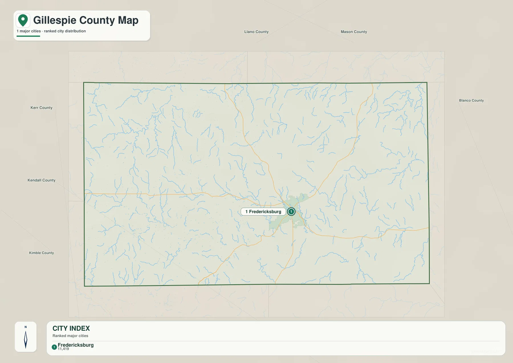
The city map highlights one ranked major city: Fredericksburg. It is listed first in the CITY INDEX with a displayed value of 11,419. There is no connector line to a second ranked city and no mileage comparison, so this graphic is not intended as a city-to-city distance map. Its strength is simplicity: it places the county’s principal highlighted settlement against a broad background of creeks, roads, and rural hill terrain.
Harper and Stonewall are clearly labeled on the general county map, but they do not appear as equivalent ranked cities in this city index. That distinction is useful when switching between the two views. The city map establishes Fredericksburg as the main urban reference, while the general map adds the smaller communities and shows how U.S. 290 links the western and eastern sides through the county center.
Fredericksburg also sits near a concentration of drainage lines. Numerous small channels descend toward the Pedernales River system, and the surrounding relief becomes obvious when the city view is compared with the water and elevation maps. Using the city index first reduces clutter and makes it easier to locate the central settlement before examining the county’s much more complex physical geography.
Pedernales River and Its Branching Creek Valleys
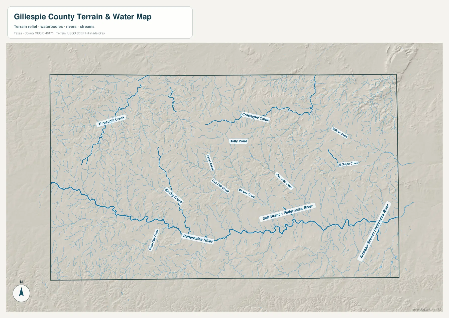
Pedernales River is the strongest water reference on the supplied terrain-and-water map. It crosses the southern portion of the county from west toward east and receives tributaries from both sides. Threadgill Creek is prominent in the northwest, while Willow Oak Creek and Spring Creek reach the Pedernales corridor from the southwest. Starting with the main river makes the dense network easier to understand because most of the smaller channels can then be placed relative to a single long valley.
Crabapple Creek crosses the north-central area and is one of the clearest named northern streams. Pecan Creek, Live Oak Creek, and Barons Creek occupy separate central valleys farther south. In the east, Palo Alto Creek and North Grape Creek stand out, with Willow Creek labeled farther northeast. Holly Pond is marked near the north-central interior and provides a small but useful water landmark among the many branching creek lines.
The eastern Pedernales corridor includes labels for Salt Branch Pedernales River and Anhalt Branch Pedernales River. In that part of the county, the main river and multiple short tributaries are closely spaced, creating a deeply dissected terrain surface. The western uplands have their own creek network, but the lower eastern drainage is especially clear when the water and elevation maps are compared side by side.
This map is intended for locating rivers, creeks, and small water bodies relative to the county terrain. It does not establish flood zones, legal water boundaries, channel depth, year-round flow, or navigability. For ordinary geographic reading, its main value is showing how the many hill-country valleys eventually connect with the Pedernales River system.
High Western Uplands and Lower Eastern Pedernales Country
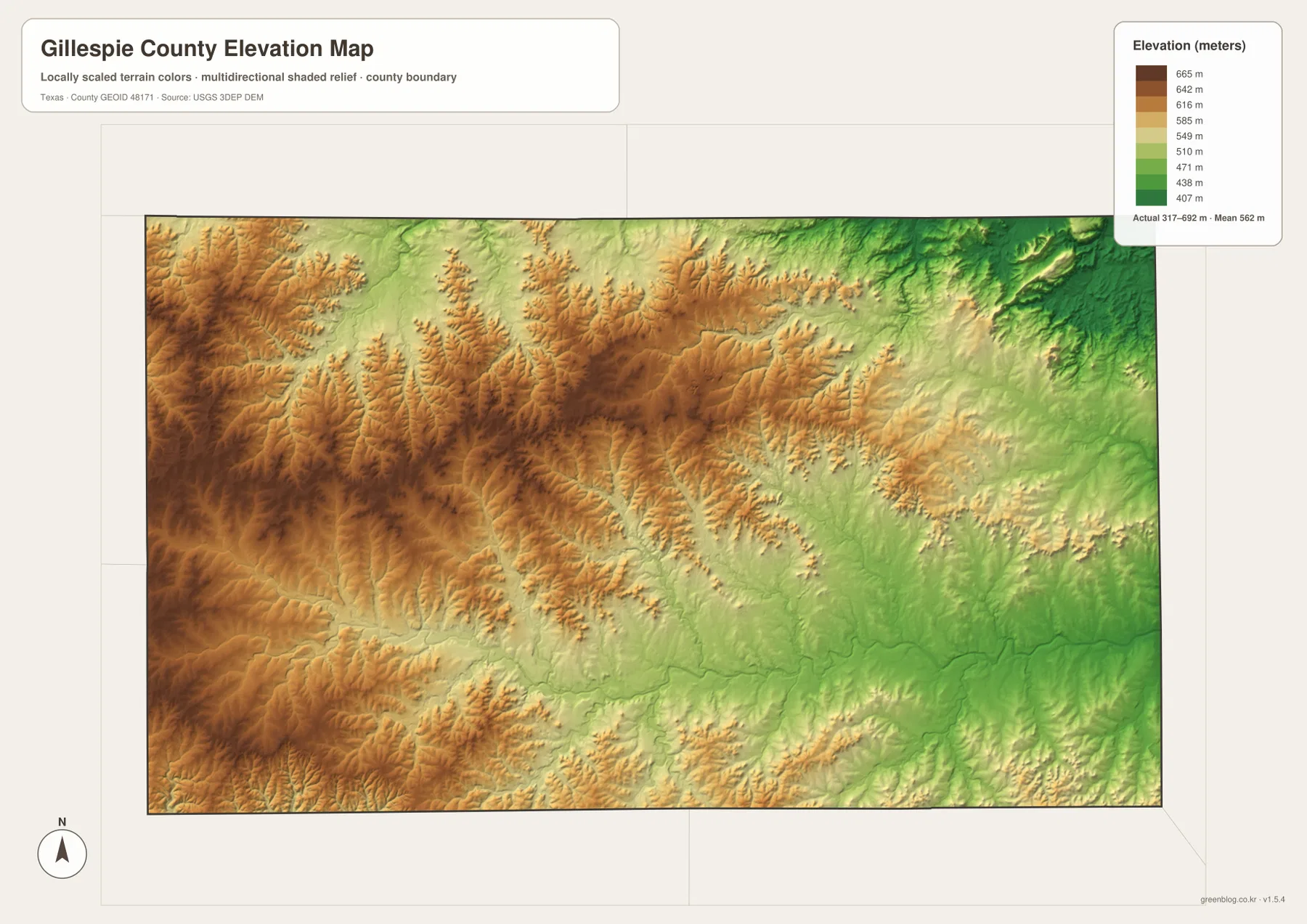
The elevation map lists an actual Gillespie County range of about 317 to 692 meters and a mean near 562 meters. Brown and dark tan colors dominate much of the west and southwest, with another broad high area across the north-central interior. Green becomes more widespread toward the east and northeast, and lower corridors follow the major river and creek valleys. The range is large enough to make a strong difference in shaded relief even though the county is not defined by one isolated mountain mass.
The western high ground is repeatedly cut by narrow valleys. Creek channels produce green or light-green fingers between higher ridges, and those cuts become broader where tributaries approach the Pedernales River. In the east, lower terrain occupies larger connected areas. Comparing the elevation surface with the water map makes it easy to see why Crabapple Creek and the Pedernales tributaries coincide with some of the lowest visible corridors.
Fredericksburg occupies an intermediate position between the highest western terrain and the lower eastern drainage. Moving toward Harper generally brings more high brown relief, while the Stonewall side contains broader lower surfaces closer to the eastern Pedernales valley. The map is intended for county-scale comparison and should not be treated as survey-grade elevation for a parcel, road grade, engineering design, or construction decision.
How the Landscape Changes from Harper to Stonewall
Following the U.S. 290 corridor from Harper through Fredericksburg toward Stonewall provides a useful west-to-east cross-section of the county. Around Harper, higher uplands and deeply cut local valleys occupy much of the surrounding map. Fredericksburg sits nearer the middle of the transition. Continuing toward Stonewall, lower green terrain becomes more common as the road approaches the eastern Pedernales drainage.
The water map makes the same change more specific. Threadgill Creek and Spring Creek help define western valleys, while Barons Creek, Palo Alto Creek, North Grape Creek, and several Pedernales branches organize the center and east. The road map alone gives a simple connection among three places; the water and elevation views explain why the landscape along that route changes so noticeably.
Choosing a Map for Roads, Creeks, or Elevation
Use the general county map when you need Fredericksburg, Harper, Stonewall, U.S. 290, U.S. 87, Highway 16, and the county road network in one view. The city index is the quickest option when the position of Fredericksburg is the main question. Choose the water map for Pedernales River, Crabapple Creek, Barons Creek, Palo Alto Creek, North Grape Creek, and smaller tributaries. The elevation view is most useful for comparing the higher western uplands with the lower eastern drainage country.
The WebP images are convenient for viewing on the page, while the ZIP below contains the matching high-resolution A3 JPG originals for printing and larger displays. The archive includes the county, city, water, and elevation maps shown here, so you can keep the full set or use only the file needed for classroom work, a presentation, local reference, or a personal map collection.
Frequently Asked Questions
What is the easiest starting point on a Gillespie County map?
Fredericksburg is the most useful starting point. U.S. 290 connects Harper on the west with Stonewall on the east, while U.S. 87 and Highway 16 provide additional north-south and southwest references around the central city.
Which waterway is the main reference on the supplied water map?
Pedernales River is the strongest reference. It runs across the southern part of the county and receives water from numerous tributaries, including creek systems associated with Crabapple Creek, Barons Creek, Palo Alto Creek, and North Grape Creek.
Where are the higher and lower parts of Gillespie County?
The elevation map places much of the highest terrain in the west, southwest, and parts of the central interior. Lower ground becomes more extensive toward the east and along the major river and creek valleys. The actual mapped range is about 317 to 692 meters, with a mean near 562 meters.
Sources and Reference Data
USGS The National Map Viewer — Official map service for roads, terrain, hydrography, and other geographic layers.
USGS National Hydrography — Official reference for rivers, creeks, lakes, and other hydrographic data.
USGS 3D Elevation Program — U.S. Geological Survey program for elevation and terrain data.
U.S. Census Bureau TIGER/Line Shapefiles — Official source for county boundaries, roads, and related base geography.
Map File Information
Download the Gillespie County county map, city map, water map, and elevation map as high-resolution A3 JPG files. The ZIP contains the original map files shown on this page.
- File Type: JPG
Related Maps
- Travis County Texas map
- Bandera County Texas map
- Real County Texas map
- Sutton County Texas map
- San Saba County Texas map
Green Map creates custom-edited map images using open geographic data sources such as geoBoundaries, Natural Earth, OpenStreetMap, and government open data.
These maps are edited visual materials, not raw data files, and are provided for education, documents, presentations, and graphic reference.