This Sutton County Map set uses Sonora as the main reference point for roads, drainage, and relief across the county. Download the high-resolution A3 JPG map ZIP from the box below when you need printable or editable files; the package contains separate county-reference, city, terrain-and-water, and elevation maps. Together they show the I-10 and U.S. 277 junction, the Dry Devils River and Llano drainage systems, and a deeply cut plateau landscape.
Sutton County may look simple on a city map because Sonora is the only ranked major city, but the terrain is much more complicated. The existing article material identifies I-10 as the east-west route through Sonora and U.S. 277 as the main north-south route. Away from town, the maps show a broad plateau broken by dense creek valleys. The western Dry Devils River drainage and the eastern North Llano and Dry Llano systems occupy different low corridors, while higher uplands remain between them.
Table of Contents
Sonora gives the road map a clear center
Sonora is the easiest place to begin on the county reference map. The existing county material places Interstate 10 on an east-west course through town and U.S. 277 on the north-south route. The preview also shows route shields 10 and 277 in the expected directions. Once those two main roads are located, the rest of the county can be read outward from Sonora rather than as a collection of unrelated local routes.
Several numbered roads cluster near the Sonora area, including 102, 202, and 467. Farther east, 864, 306, and 313 become useful references, while the southern half includes 312, 314, 320, and 406. The western side has labels such as 110, 410, and 189. These numbers add detail for ranch roads and outer parts of the county, but I-10 and U.S. 277 remain the strongest orientation lines.
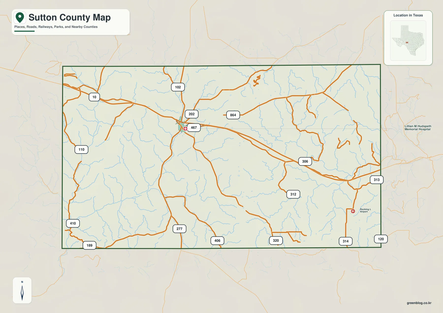
The stream pattern makes the map look far more rugged than a simple highway diagram. Thin blue channels branch across both the west and east, often cutting across the straighter road network. That contrast is useful because it shows that travel routes cross a landscape of narrow valleys rather than a perfectly flat open surface. The water and elevation maps make those valleys much easier to interpret.
The city view treats Sonora as the single major settlement anchor
The ranked city map highlights only Sonora. With most local road labels removed, the marker sits slightly west of the county’s center and the surrounding drainage becomes easier to see. This map is not designed to compare several urban centers. Its main value is to give one unmistakable location reference inside a large, lightly settled county.
The CITY INDEX prints Sonora at 2,691. That figure should be treated as the value used by the supplied graphic, not as a guaranteed current population estimate. Anyone needing an up-to-date demographic count should use an official statistical source. For map reading, the important fact is that Sonora is the only ranked major city and therefore becomes the anchor for roads, drainage, and neighboring counties.
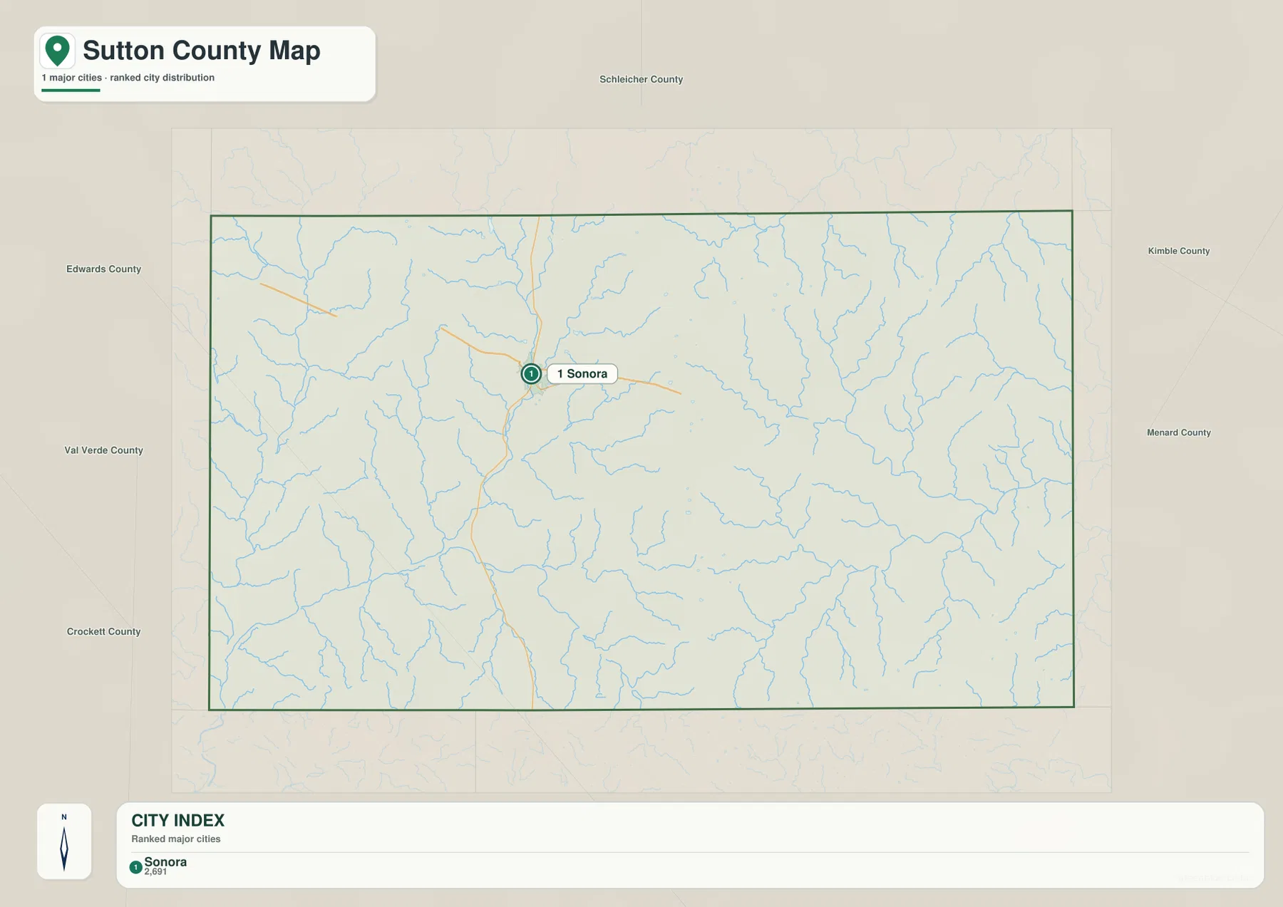
The neighboring county labels provide additional orientation. Schleicher County is shown to the north. Edwards and Val Verde counties appear on the western side, Crockett County is southwest, and Kimble and Menard counties lie to the east and northeast. With Sonora fixed in the middle, those labels help place Sutton County within the surrounding plateau counties without crowding the map with extra town names.
Dry Devils River and the Llano systems drain different sides of the plateau
The terrain-and-water map has two distinct sets of large drainage references. On the western side, the Dry Devils River runs southward through a deeply cut valley and bends toward the southwest. Several small labeled sites appear near its upper course, including Site No 6, Site No 8, Site No 9, Site No 10, Site No 11, and Site No 12. Middle Valley Prong is labeled along the northern part of the map, adding another reference for the upper western drainage.
The eastern half is organized around the North Llano River and Dry Llano River. North Llano River follows a strong bending channel through the east-central area, while Dry Llano River forms a separate corridor to the south. Epps Creek is labeled in the northeast, McCamley Creek joins the eastern drainage farther south, and Maynard Creek appears close to the southeastern edge. These names make the eastern drainage much easier to distinguish from the Dry Devils River side.

A practical way to read the water map is to separate the Dry Devils drainage in the west from the Llano drainages in the east, then trace the smaller tributaries into those larger valleys. This layer is intended for geographic reference. It does not replace flood-hazard mapping, parcel boundaries, navigation information, or detailed water-management data.
Plateau uplands rise above deeply cut river valleys
The elevation map reports an actual range of about 558 to 758 meters and a mean elevation of 684 meters. Brown and tan high ground occupies broad parts of the north and northeast, and rugged ridges are especially visible across the eastern half. Lower green terrain extends through the southwest and along several central valleys, creating a strong visual contrast with the plateau surfaces above them.
The terrain is not a simple slope in one direction. Higher surfaces remain in the central interior, while narrow lower valleys cut into them from several sides. In the west, the Dry Devils River corridor matches one of the strongest low pathways on the relief map. In the east, the North Llano and Dry Llano systems occupy similarly dissected terrain. Comparing the two maps shows why Sutton County looks like a high plateau carved by repeated drainage valleys rather than a smooth plain.
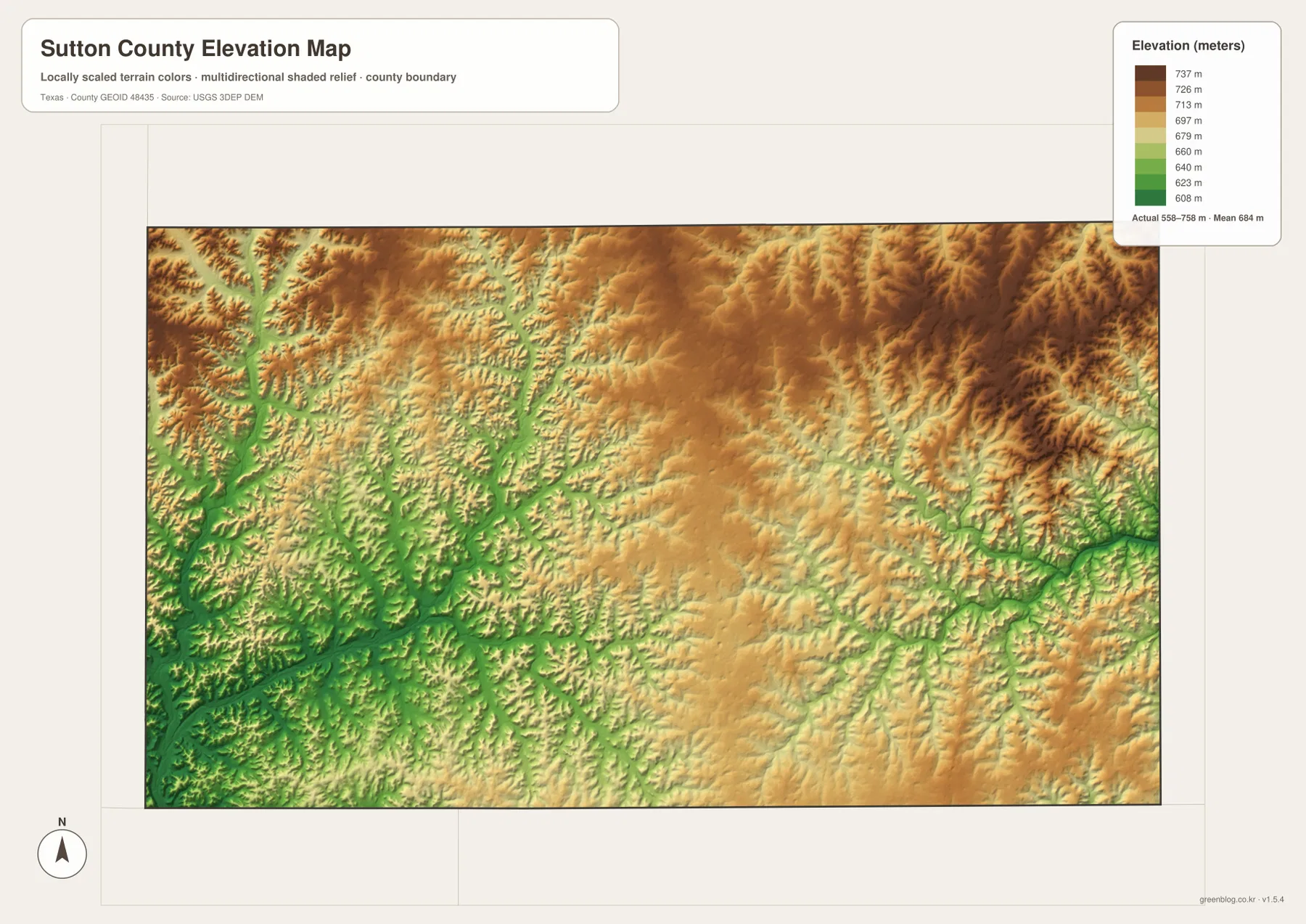
This countywide elevation surface is meant for broad terrain comparison rather than parcel surveying or engineering design. It is useful for identifying the major uplands, following lower river and creek corridors, and understanding how the land around Sonora fits between the western Dry Devils and eastern Llano drainage systems. Exact site elevation should be checked with detailed source data or a local survey.
Choose the map by whether roads, drainage, or relief matters most
Use the county reference map when Sonora, I-10, U.S. 277, local route numbers, and the county boundary need to appear together. The city map is cleaner when Sonora alone should stand out. The terrain-and-water view is the best place to compare the Dry Devils River with the North Llano and Dry Llano systems, while the elevation map makes the high plateau surfaces and deeply cut valleys easiest to compare.
The downloadable ZIP contains four separate high-resolution A3 JPG files for Sutton County: county reference, ranked city, terrain and water, and elevation. You can inspect the lighter WebP versions in the article first and then use the larger JPG files for printing, classroom material, presentations, or an editable local-reference document.
Frequently Asked Questions
Where do I-10 and U.S. 277 meet in Sutton County?
The existing article material and supplied reference map place their main county junction at Sonora. I-10 provides the east-west orientation, while U.S. 277 provides the north-south reference.
Do the Dry Devils River and North Llano River follow the same drainage?
No. The terrain-and-water map shows them as separate large valley systems. Dry Devils River occupies the western side, while North Llano River is a major reference in the eastern half of the county.
What elevation range is shown for Sutton County?
The supplied elevation map states an actual range of about 558 to 758 meters and a mean of 684 meters. Higher plateau terrain is widespread in the north and east, while several southwestern and central valleys are lower.
Map File Information
The ZIP contains the four Sutton County maps in high-resolution A3 JPG format.
- Included Versions: County reference, ranked city, terrain and water, elevation
- Included Files: 4 A3 JPG maps
Related Maps
Sources and data references
Roads and county boundaries around Sonora can be cross-checked with the U.S. Census Bureau TIGER/Line Shapefiles. The Dry Devils River, North Llano River, Dry Llano River, and named creeks can be checked against USGS National Hydrography, while terrain height data are available through the USGS 3D Elevation Program. Route labels, place references, water features, and the 558–758 meter elevation range described above are based on the Sutton County maps and existing article material supplied in this package.
Green Map creates custom-edited map images using open geographic data sources such as geoBoundaries, Natural Earth, OpenStreetMap, and government open data.
These maps are edited visual materials, not raw data files, and are provided for education, documents, presentations, and graphic reference.