You can download high-resolution JPG maps of Grant County, South Dakota, while using the WebP versions on this page to examine the county’s roads, communities, waterways, and elevation. Milbank is the easiest place to orient yourself because it sits in the east-central part of the county near US 12. Big Stone City lies farther northeast, while Revillo, La Bolt, Stockholm, and Strandburg are spread across the southern half. The county also has a striking physical contrast: broad high ground occupies much of the west, then the land drops toward the lower eastern side where the Whetstone River forks and several other waterways are mapped.
The outline deserves attention before any individual feature. Grant County is not a simple rectangle. Its western section extends far to the left, the southwest boundary steps inward, and a large southeastern block continues below the narrower middle. That shape affects how the towns, roads, and rivers appear on every map. Once the boundary is familiar, Milbank and the US 12 corridor provide a useful reference for moving between the general map, the city distribution map, the terrain-and-water map, and the elevation map.
The elevation legend reports an actual mapped range of about 277 to 629 meters, with a mean near 442 meters. Browns and tans cover much of the west, while greens dominate large parts of the east. The water map helps explain why that contrast matters: South Fork Whetstone River crosses the central area toward the east, North Fork Whetstone River occupies the northeast, and the two Yellow Bank River forks run through the southern part of the county. Looking at the water and elevation maps together gives a clearer picture than treating either one as a separate layer.
Table of Contents
Milbank is the best starting point for roads and the stepped county boundary
On the general map, Milbank stands out in the east-central part of Grant County. US 12 approaches from the west and continues toward Milbank, giving the northern half a clear east-west reference. Farther south, route numbers 158, 20, and 15 appear around the southeastern block. On the western side, 29 and 81 are labeled near the outer portion of the county. You do not need to memorize every route number; finding Milbank and US 12 first makes the rest of the map much easier to organize.
The boundary is equally useful. The wide western extension narrows at the southwest step, then the county expands again into the southeastern section. Stockholm and Strandburg sit in the southern part of this lower block, while Revillo and La Bolt are farther east. That arrangement is easier to understand after tracing the county outline once. It also prevents a common visual mistake: assuming that the western and southern sections occupy the same east-west span when the boundary shows that they do not.
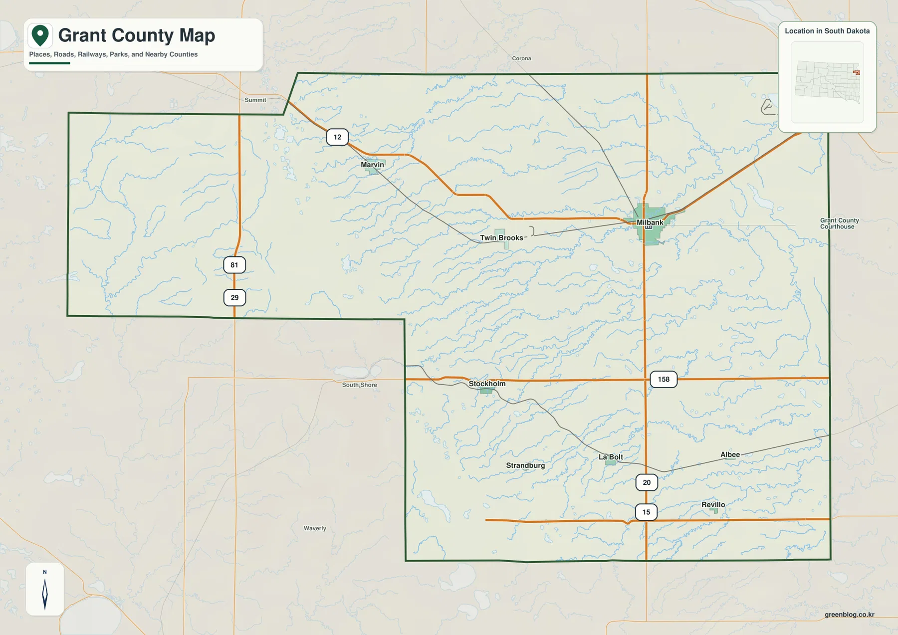
This map is meant for county-scale orientation rather than parcel research or turn-by-turn navigation. It shows named places, major roads, rail lines, nearby counties, and the broad boundary clearly enough to compare locations. Detailed addresses, legal parcel lines, and current driving directions require more specialized sources, but the general map is the most efficient place to establish a reference point before switching to the other views.
Big Stone City and four southern communities give the county an uneven settlement pattern
The city distribution map highlights Milbank, Big Stone City, Revillo, La Bolt, Stockholm, and Strandburg. Milbank is in the east-central area, while Big Stone City sits close to the northeast corner. Revillo and La Bolt are well to the south and remain on the eastern side. Stockholm and Strandburg extend the group farther west across the southern part of the county. Seeing all six points without a dense road layer makes their relative positions easier to compare.
The numbers in the city index are part of the supplied map’s ranking display. They should not be read as a tourism score or a legal classification of the municipalities. The useful information is geographic: two highlighted communities occupy the east and northeast, while four others spread across the south. This distribution also shows why Milbank is such a practical reference point. It is not centered in the county outline, but it sits close to several eastern roads and near the lower terrain that dominates much of the right-hand side.
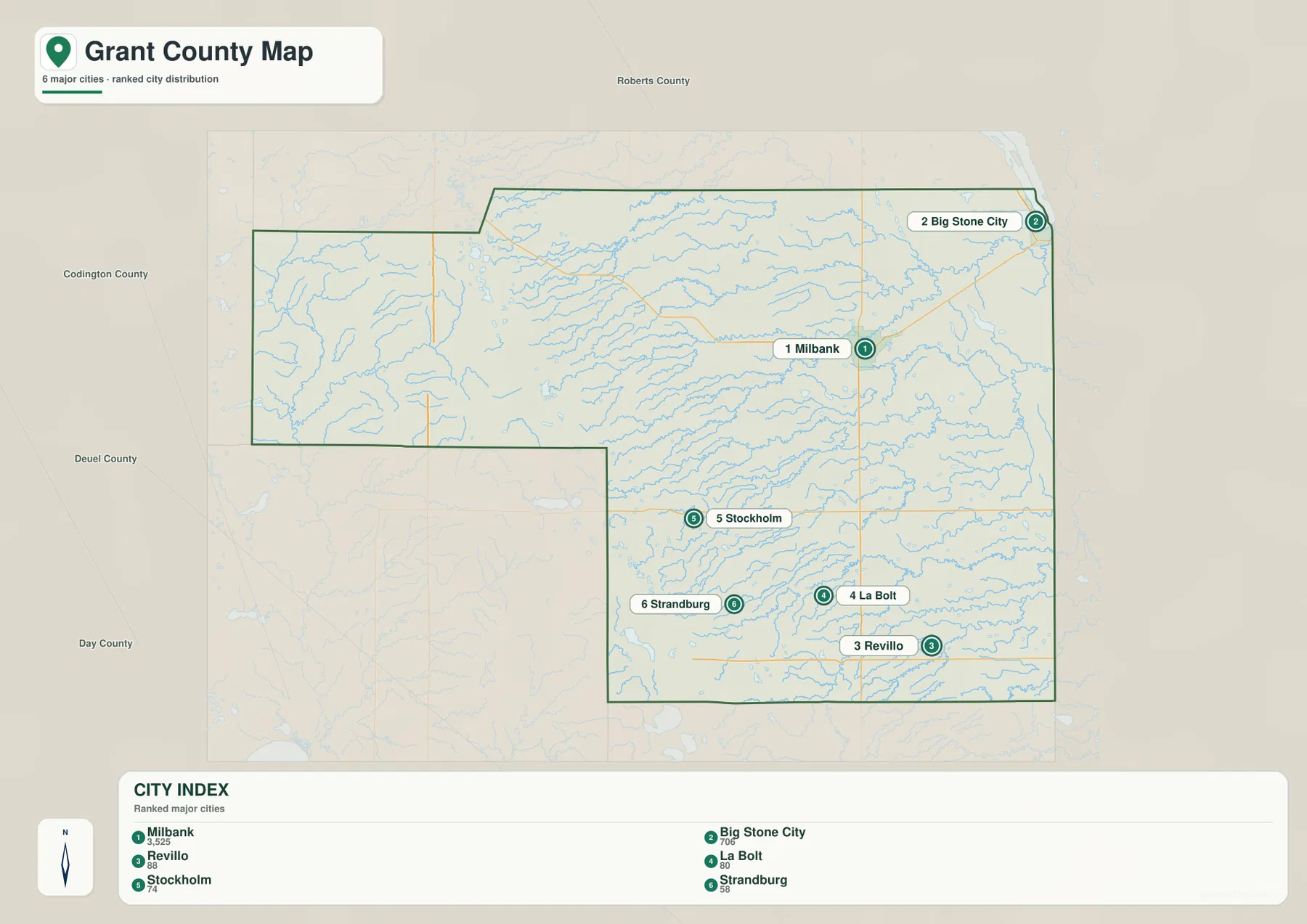
No mileage values or connecting distance lines are drawn on this city map. It is therefore a location-comparison map, not a road-distance calculator. The surrounding labels help with regional orientation as well: Roberts County is to the north, Codington County is to the west, and Deuel and Day counties appear to the southwest and south. For actual travel time or driving distance, a current navigation service should be used instead.
Whetstone and Yellow Bank river forks run through the lower eastern terrain
The terrain-and-water map brings out a different set of landmarks. Big Sioux River is labeled along the western side, with Indian River nearby. South Fork Whetstone River crosses a broad central corridor toward the east and passes near Lake Farley. North Fork Whetstone River appears separately in the northeast near Lake Albert. Together, those two Whetstone branches make the eastern drainage much easier to follow than on the road-focused general map.
The southern section has two long Yellow Bank River branches. North Fork Yellow Bank River winds across the upper part of the south, and South Fork Yellow Bank River lies farther down before continuing toward the eastern edge. Mud Creek is labeled near the southeast. Several named lakes add useful reference points: Summit Lakes and Twin Lakes are in the northwest, Myers Lake is closer to the center, Lake Farley and Lake Albert are in the east, and Crooked Lake and Mud Lake appear in the southern area.
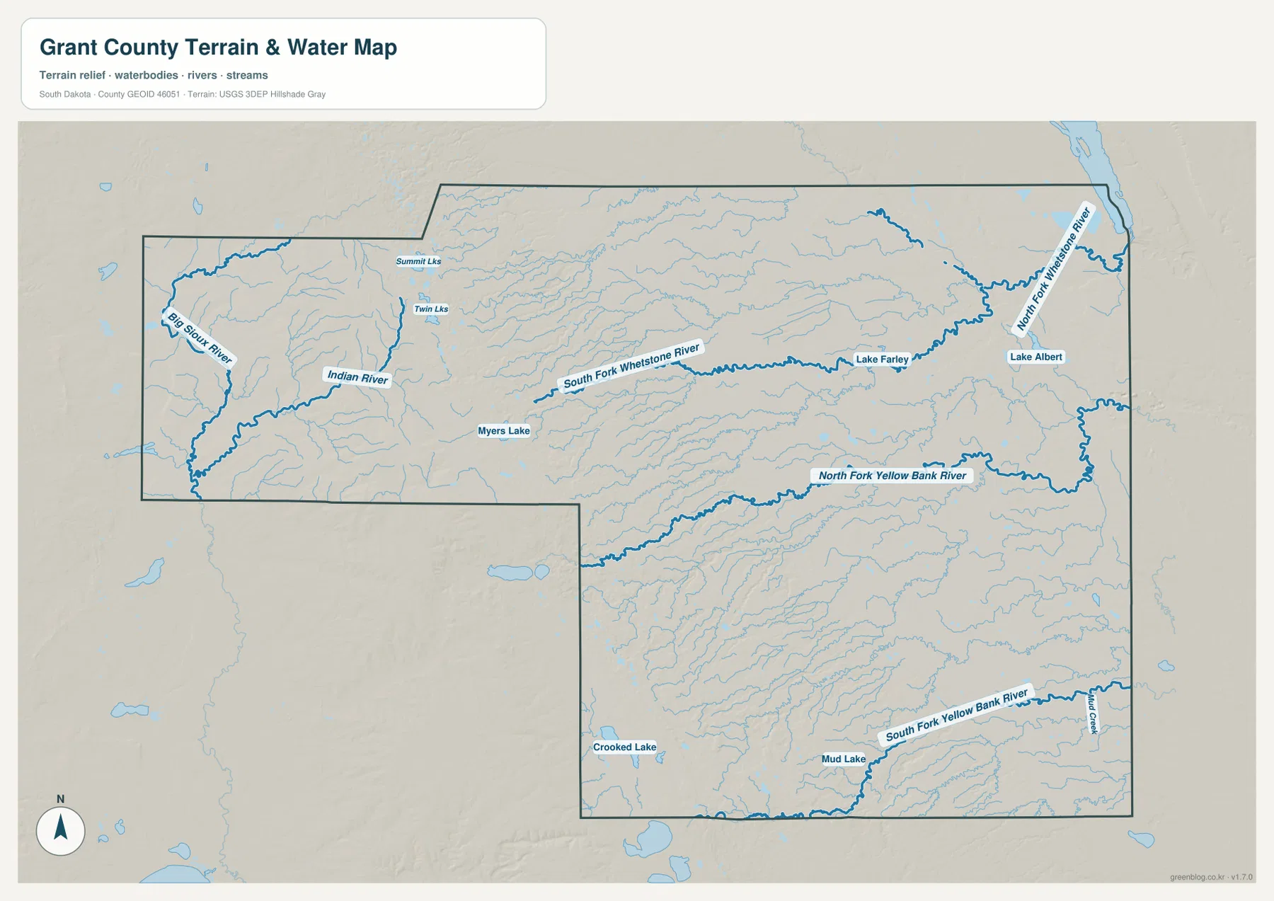
This is a county-scale hydrography reference, not a flood map or a legal shoreline record. It does not show water depth, flood probability, ownership, or current stream conditions. Its strength is the arrangement of named rivers, forks, creeks, and lakes within the same county boundary used by the other maps. When the water lines are compared with the elevation colors, the eastward drainage and the lower valleys become much easier to recognize.
The western high ground drops more than 300 meters toward the low eastern side
The elevation map gives Grant County its clearest visual contrast. The west is dominated by brown and tan colors, indicating the county’s higher terrain. Moving toward the center, those colors transition through yellow and light green, and much of the east becomes medium or dark green. The legend lists an actual range of roughly 277 to 629 meters and a mean of about 442 meters. That puts about 352 meters between the mapped low and high values.
The change is not a smooth straight slope. Higher ground pushes eastward in some places, while lower valleys cut back toward the center. Those narrow lower corridors become more meaningful when matched with the water map. South Fork Whetstone River and the Yellow Bank branches occupy areas where the green terrain and valley shapes are more visible. Milbank and Big Stone City are also on the lower eastern side rather than on the brown western uplands.
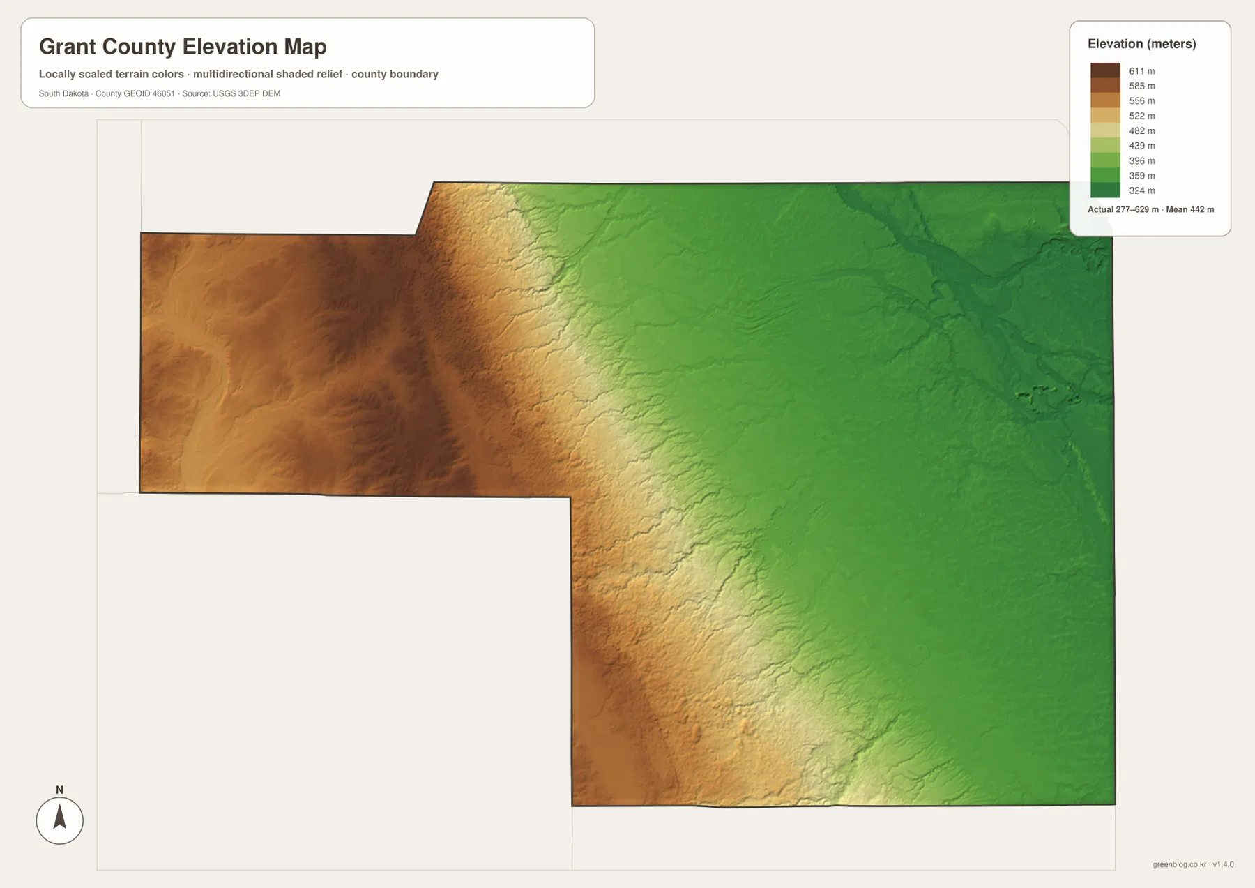
The color surface is useful for broad comparison, not precise surveying. It should not be used as an exact elevation reading for a building, field, road, or parcel. For county-scale interpretation, however, the main pattern is straightforward: high ground occupies the west, lower terrain spreads across the east, and several river valleys cut through the transition. The USGS 3D Elevation Program is the appropriate source when exact elevation data are required.
Follow one place across the maps instead of reading each map in isolation
A useful way to compare the maps is to keep one place fixed. Start with Milbank on the general map and note US 12 and the unusual county boundary. Move to the city map to compare Milbank with Big Stone City to the northeast and with Revillo and La Bolt farther south. Then look at the Whetstone River branches on the water map. On the elevation map, the same eastern area appears much lower than the western extension. One location now connects roads, communities, drainage, and relief without forcing all of those details into a single crowded image.
The southern part works the same way. Locate Revillo, La Bolt, Stockholm, and Strandburg, then compare their positions with North Fork and South Fork Yellow Bank River. The elevation colors show that the western side of the southern block is generally higher than the eastern side. In the long western extension, Big Sioux River, Indian River, Summit Lakes, and Twin Lakes provide water references while the elevation map shows broad higher ground. This approach keeps the maps tied to real places rather than treating them as four unrelated illustrations.
The WebP images are optimized for quick viewing in the article. The downloadable archive contains the corresponding high-resolution JPG files at 3638 × 2572 pixels each. They are suitable for A3 printing, classroom material, presentations, regional comparisons, and personal reference when a larger image is more useful than the on-page preview.
Frequently Asked Questions
Why is Milbank a useful reference point on the Grant County maps?
Milbank is in the east-central part of the county near US 12 and several north-south roads. It is also easy to compare with Big Stone City to the northeast and with the southern communities. From Milbank, the maps make the major west-to-east elevation change especially clear because the western extension lies on much higher terrain.
Does the city distribution map show driving distance between the communities?
No. The supplied city map has no distance lines or mileage labels. It is designed to show the relative positions of Milbank, Big Stone City, Revillo, La Bolt, Stockholm, and Strandburg. Driving distance and travel time should be checked with a current road or navigation source.
What becomes clearer when the water and elevation maps are compared?
The elevation map shows high western ground and a much lower eastern side, while the water map traces the Whetstone and Yellow Bank river forks through that lower country. Matching the two makes the river valleys easier to place and shows how the county’s drainage fits the broad west-to-east drop in elevation.
Map File Information
The ZIP includes high-resolution JPG versions of the Grant County general map, city distribution map, terrain-and-water map, and elevation map.
- Included Files: 4 JPG maps
- Printable Size: 3638 × 2572 px each
Related Maps
Sources and references
- Grant County, South Dakota official website – county services, contacts, and local government information.
- U.S. Census Bureau TIGER/Line Shapefiles – official geographic boundary and road-reference data.
- USGS National Hydrography – authoritative resources for rivers, streams, lakes, and other hydrography.
- USGS 3D Elevation Program – national elevation and terrain data resources.
Green Map creates custom-edited map images using open geographic data sources such as geoBoundaries, Natural Earth, OpenStreetMap, and government open data.
These maps are edited visual materials, not raw data files, and are provided for education, documents, presentations, and graphic reference.