A Chilton County Map becomes much easier to read once Clanton is used as the main reference point. Interstate 65 and U.S. 31 create a strong north–south corridor through central Alabama, linking Clanton with Thorsby and Jemison, while Maplesville sits well to the west. On the eastern side, smaller creeks drain toward Lay Lake and the Coosa River system. This page includes county, city, water, and elevation previews, plus a downloadable ZIP of high-resolution A3 JPG files for printing, classroom work, presentations, and offline map projects.
The county is not a flat block organized around one highway. Rolling uplands cover much of the interior, stream valleys cut through those hills, and the broad water of Lay Lake changes the eastern edge. Starting with roads and towns, then comparing water and elevation, gives a clearer picture of how the different parts of Chilton County relate to one another.
Table of Contents
Clanton anchors the main north–south road corridor
Clanton is the easiest place to start on the general county map. Interstate 65 passes just east of the city and continues north toward Thorsby and Jemison, while U.S. 31 follows a broadly similar direction. This creates a recognizable central corridor where several of the county’s best-known communities are concentrated.
East–west routes add a second pattern. Alabama 22 crosses through the Clanton area, and U.S. 82 is important farther west. Maplesville lies away from the interstate corridor, which gives the western side of the county a more rural road pattern. Toward the east, routes approach Lay Lake and the Coosa River system, where bridges and water crossings can matter more than a simple straight-line distance.
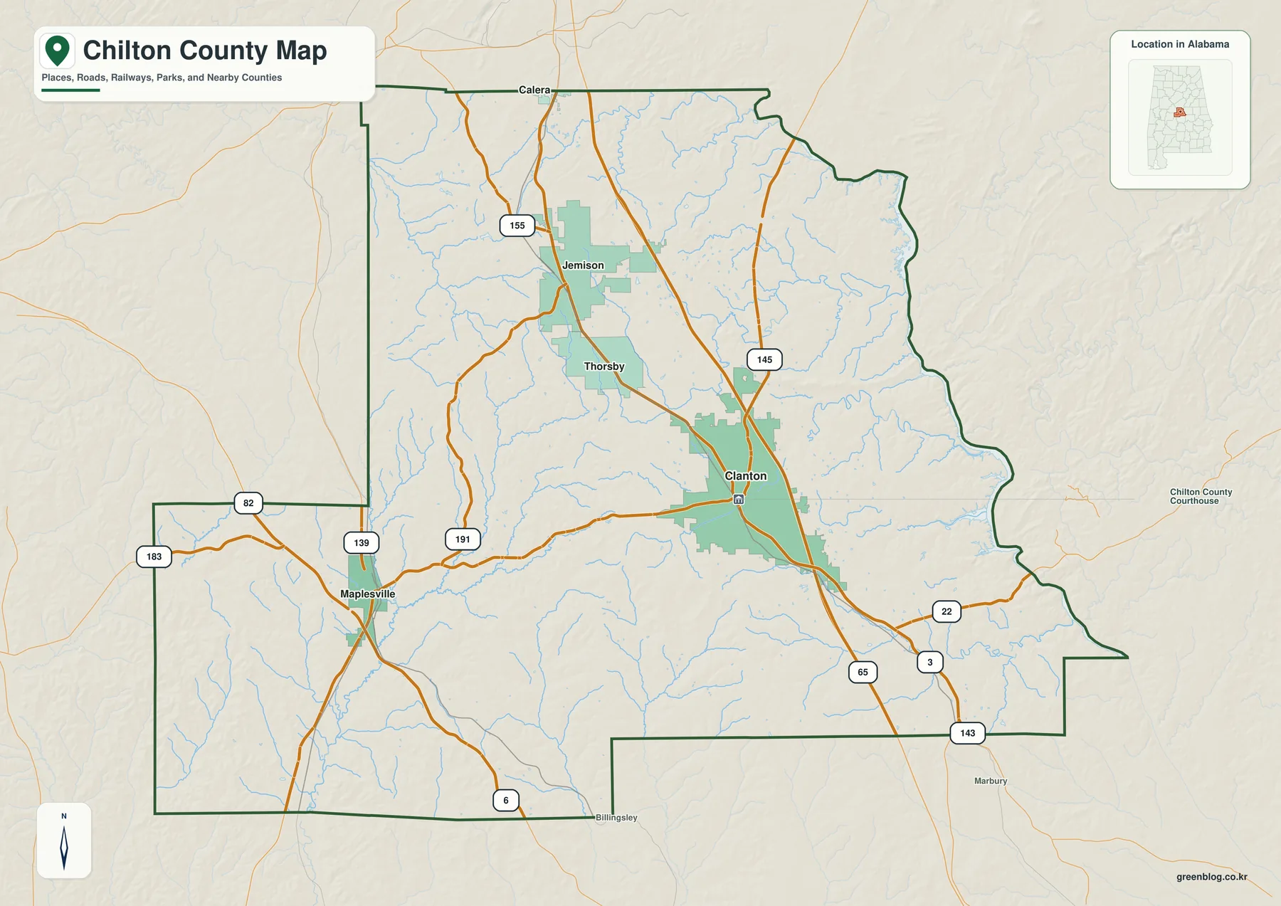
The surrounding counties also help place Chilton County within central Alabama. Shelby lies to the north, Bibb and Perry are toward the west, Dallas and Autauga are to the south, and Elmore and Coosa are on the eastern side. The map is useful for regional orientation, but current travel routes and road conditions should still be checked separately.
Jemison and Thorsby follow the central corridor while Maplesville sits west
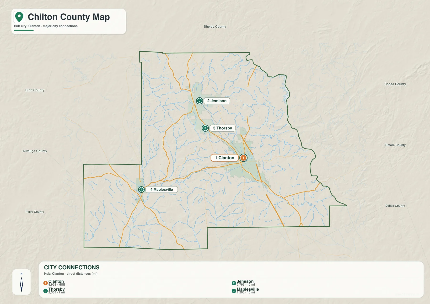
The city map strips away most road detail so the relative placement of Clanton, Thorsby, Jemison, and Maplesville is easy to compare. Thorsby and Jemison both lie north of Clanton along the same general corridor, while Maplesville is distinctly west. That difference shows why the county cannot be understood only from Interstate 65.
Distance labels on the city graphic are straight-line measurements based on mapped coordinates. They are not driving mileage or travel time. Actual trips can be longer because roads curve, local routes do not always follow the shortest path, and intersections or bridge crossings can change the route.
Creeks cross the interior before reaching Lay Lake and the Coosa system
Water gives the eastern side of Chilton County a distinct appearance. Lay Lake, an impoundment on the Coosa River, is the largest and most visually obvious water feature near the county’s eastern edge. Inland, many smaller streams—including Yellow Leaf Creek, Walnut Creek, and Chestnut Creek—occupy short valleys between rolling uplands.
The central and western parts of the county contain numerous smaller channels, but none dominates the map the way Lay Lake does in the east. Around the reservoir, the shoreline bends into coves and tributary mouths, creating a much more irregular edge than the political boundaries elsewhere on the map.
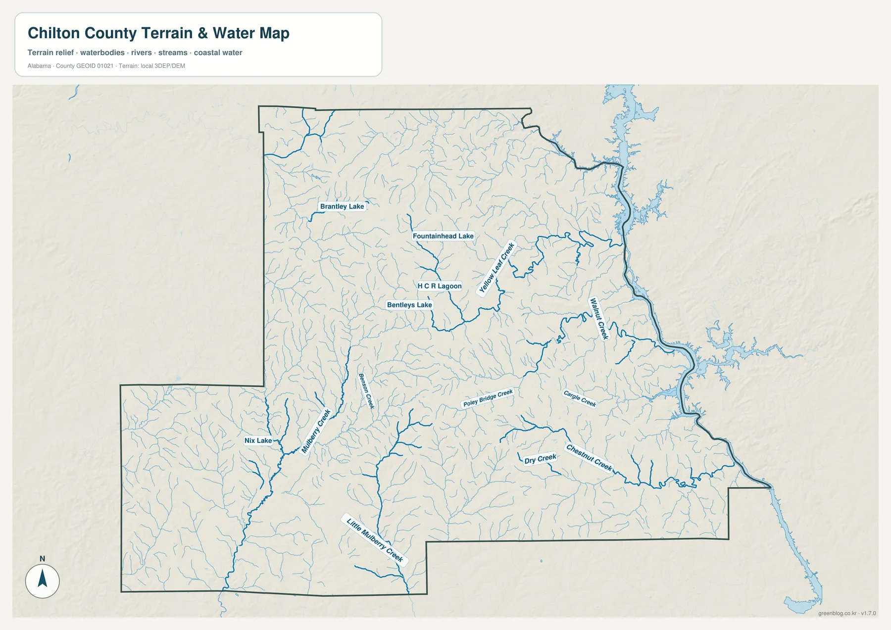
This is a county-scale reference map, not a flood-hazard, parcel, navigation, or legal-boundary product. It does not show water depth or every small stream, so site-specific decisions should rely on current official hydrologic and local data.
A 65–264 meter range reveals rolling uplands and lower valleys
The elevation map shows a local range of roughly 65 to 264 meters, with an average near 160 meters. These values describe rolling hill country rather than mountain terrain. Higher ground appears through much of the central and north-central interior, while lower areas follow stream valleys, parts of the southwest, and sections of the eastern water system.
Comparing elevation with the water map is especially useful. Many small creeks follow lower corridors between rounded uplands, which helps explain the dense pattern of short valleys across the county. Roads and communities occupy a mixture of ridges, slopes, and gentler ground rather than one continuous plain.
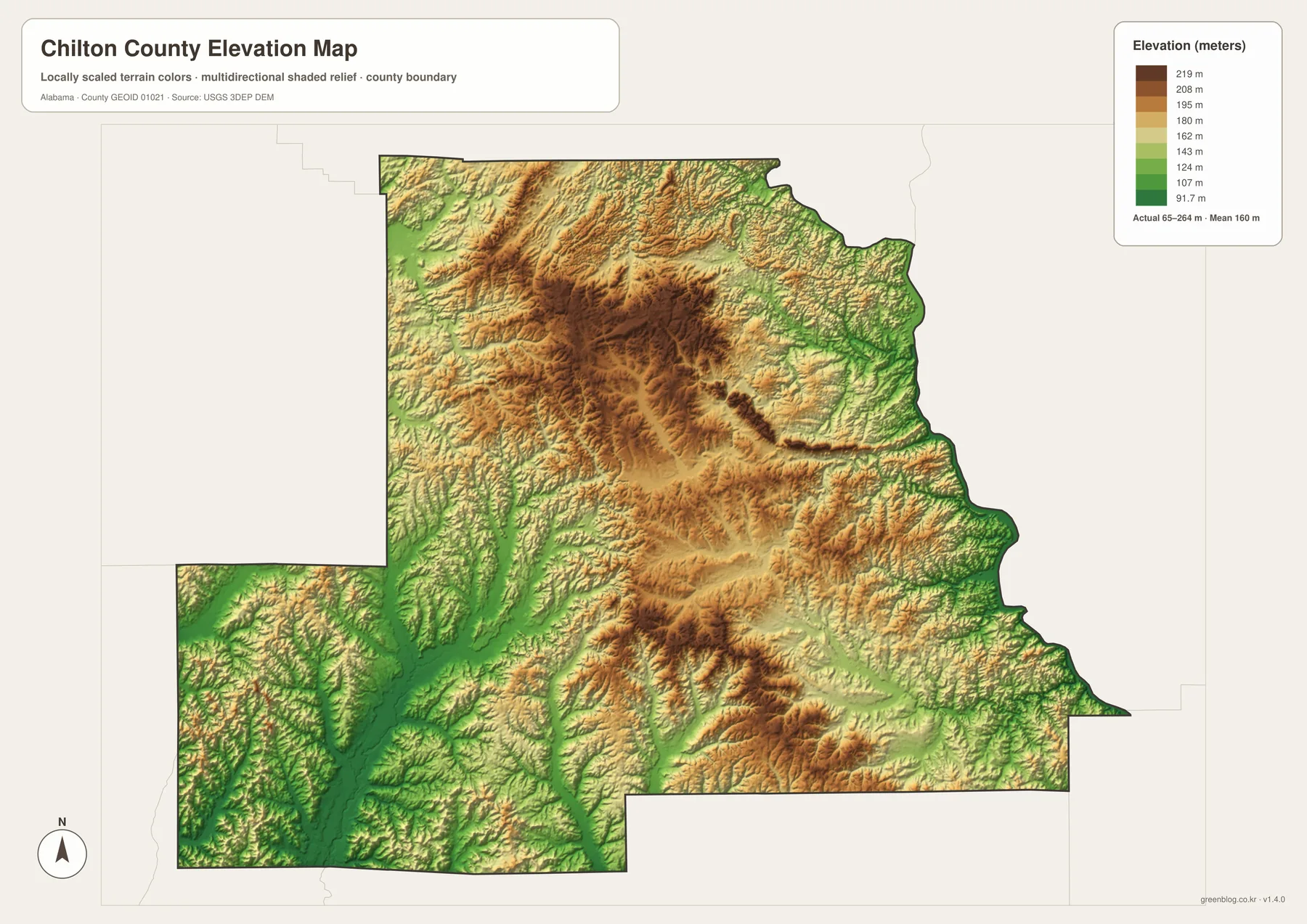
The elevation surface is generalized for county-wide viewing. It is useful for comparing broad terrain differences but should not be used as survey-grade or engineering-grade elevation information for an individual property.
Choose the map that fits the question
For basic orientation, use the county map to locate Clanton, the central road corridor, and surrounding counties. The city map is better when the goal is to compare Thorsby, Jemison, and Maplesville without extra road detail. The water view works best for Lay Lake and the creek network, while the elevation view explains the hills and lower valleys beneath those features.
- Roads and boundaries: locate Clanton, major routes, and neighboring counties.
- Community pattern: compare the central corridor with Maplesville to the west.
- Water: trace Lay Lake, the Coosa River system, and smaller creeks.
- Terrain: compare rolling uplands with lower drainage valleys.
Chilton County is widely associated with peach growing, but the maps add geographic context to that identity. The agricultural landscape is rolling rather than flat, local creeks cross the interior, and the I-65 corridor gives Clanton and nearby towns direct access to a major north–south route. The western rural area and eastern reservoir setting add two more distinct parts of the county.
Download the Chilton County A3 JPG map files
The ZIP below contains high-resolution JPG versions of the county, city, water, and elevation maps. The WebP images in the article are designed for quick browser viewing, while the larger JPG files are better suited to printing, classroom handouts, posters, presentations, and other offline uses.
Frequently Asked Questions
Are the mile labels on the city map driving distances?
No. The distances between Clanton and Thorsby, Jemison, and Maplesville are straight-line measurements based on map coordinates. Actual road mileage and travel time will be different.
Can the water map be used to evaluate flood risk?
No. It is a county-scale reference map showing major water features and selected streams. Flood-risk, property, engineering, or legal decisions require current specialized data from the appropriate agencies.
What files are included in the download ZIP?
The archive contains four high-resolution A3 landscape JPG files: a county map, city-connections map, water map, and elevation map.
Map File Information
Download Chilton County maps for roads, communities, waterways, and terrain.
- Included Files: county map, city map, water map, elevation map
- File Type: high-resolution JPG files in one ZIP
- Intended Use: printing, education, presentations, and regional reference
Related Maps
More Alabama County Maps
- Across the Warrior Headwaters: Blount County Alabama Map
- Along the Cahaba Valley: Bibb County Alabama Map
- Autauga County Map
Sources and county references
- Chilton County Commission official website
- ALDOT Chilton County functional-classification map
- USGS National Hydrography
- USGS 3D Elevation Program
- Outdoor Alabama: Lay Lake
- The Encyclopedia of Alabama: Chilton County
Green Map creates custom-edited map images using open geographic data sources such as geoBoundaries, Natural Earth, OpenStreetMap, and government open data. These maps are edited visual materials, not raw data files, and are provided for education, documents, presentations, and graphic reference.