A Cherokee County Alabama Map is easiest to understand when Centre, Weiss Lake, and the higher Little River country are treated as parts of the same landscape. The reservoir spreads through a large section of the county, separating communities that can look close on a small map, while the northeastern corner rises into rougher ridge-and-valley terrain. This page includes road, city, water, and elevation previews, and a downloadable ZIP with high-resolution A3 JPG files for printing, classroom use, presentations, and offline map projects.
Centre is the most useful starting point for orientation. Leesburg lies to the west and northwest across the lake area, Cedar Bluff is farther north where the reservoir narrows, Gaylesville sits toward the northeastern side, and Sand Rock provides a western reference. Once these communities are located, the county’s road pattern, branching shoreline, and changing elevation become much easier to follow.
Table of Contents
Start with Centre, the road network, and the county frame
Centre works well as a geographic anchor because it sits close to the eastern side of Weiss Lake and near the county’s main road connections. From there, routes extend toward communities on other sides of the reservoir and toward the higher northeastern terrain. Water and ridges matter when reading this map: places that appear close in straight-line distance can require a longer road trip because only certain bridges and road corridors cross the lake and valleys.
Cherokee County lies along Alabama’s northeastern edge near Georgia. Moving away from Centre toward Gaylesville and the Little River area, the landscape becomes more broken and elevated. The overview map is therefore most useful for seeing how roads, towns, county boundaries, and the reservoir fit together rather than for measuring exact driving distance.
Communities sit on different sides of the reservoir
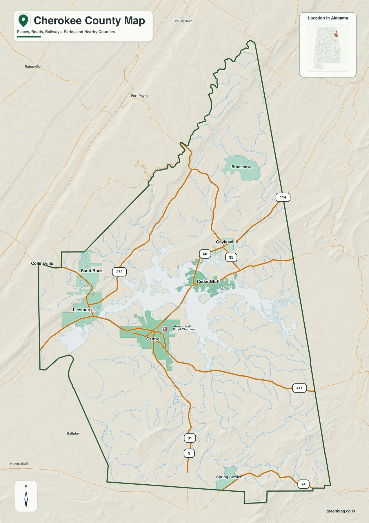
The city-focused view removes much of the background detail and makes the relative positions of Centre, Leesburg, Cedar Bluff, Gaylesville, Sand Rock, and nearby communities easier to compare. Centre remains the main reference point, but the map also makes clear that Cherokee County is not organized around one compact cluster. The reservoir, ridges, and available crossings separate places that belong to different parts of the county.
Leesburg is associated with the western and northwestern side of the lake, Cedar Bluff lies farther north, and Gaylesville is positioned toward the northeastern uplands and Georgia side. Sand Rock adds a western comparison. Any connector lines or distance labels should be read as straight-line references rather than road mileage; actual travel can be considerably longer where roads must go around water or through ridge-and-valley terrain.
Weiss Lake reaches deep into the county through branching arms
Weiss Lake dominates the water map because it is not shaped like a compact natural lake. Broad areas of open water narrow into long arms and coves that extend along valleys, creating a shoreline that cuts deeply into the surrounding land. Centre, Leesburg, and Cedar Bluff can all be described as lake-area communities, but each faces a different part of this branching reservoir system.
The northeastern side introduces a different water pattern. Little River and smaller streams descend through higher terrain before reaching larger valleys and downstream systems. With road labels reduced, the water map makes it easier to trace these channels and see how they connect with the reservoir landscape. It also helps explain why roads and settlements do not follow simple straight lines across the county.
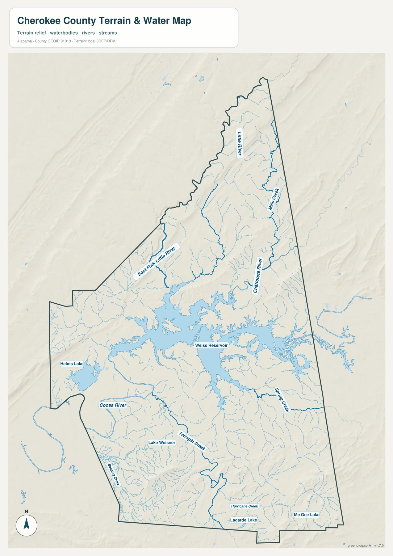
This is a geographic reference map, not a flood-hazard, navigation, or legal-boundary product. Flood zones, current water levels, boating restrictions, regulated shorelines, and property limits should be checked with the appropriate official sources.
Terrain climbs from reservoir lowlands toward Little River Canyon
The elevation view makes one of the county’s strongest contrasts visible. Much of the land around the broad reservoir basin is comparatively low, which allows water to spread into wide inlets and branching coves. To the north and east, ridges become longer, valleys narrower, and the surface more rugged as the landscape approaches the Little River Canyon area.
Relief also helps explain the arrangement of roads and streams. Water follows lower valleys between ridges, and roads often use easier passages or limited crossings through the terrain. Comparing the water and elevation views side by side gives useful context for why the northeastern part of Cherokee County feels very different from the lower country around the main body of Weiss Lake.
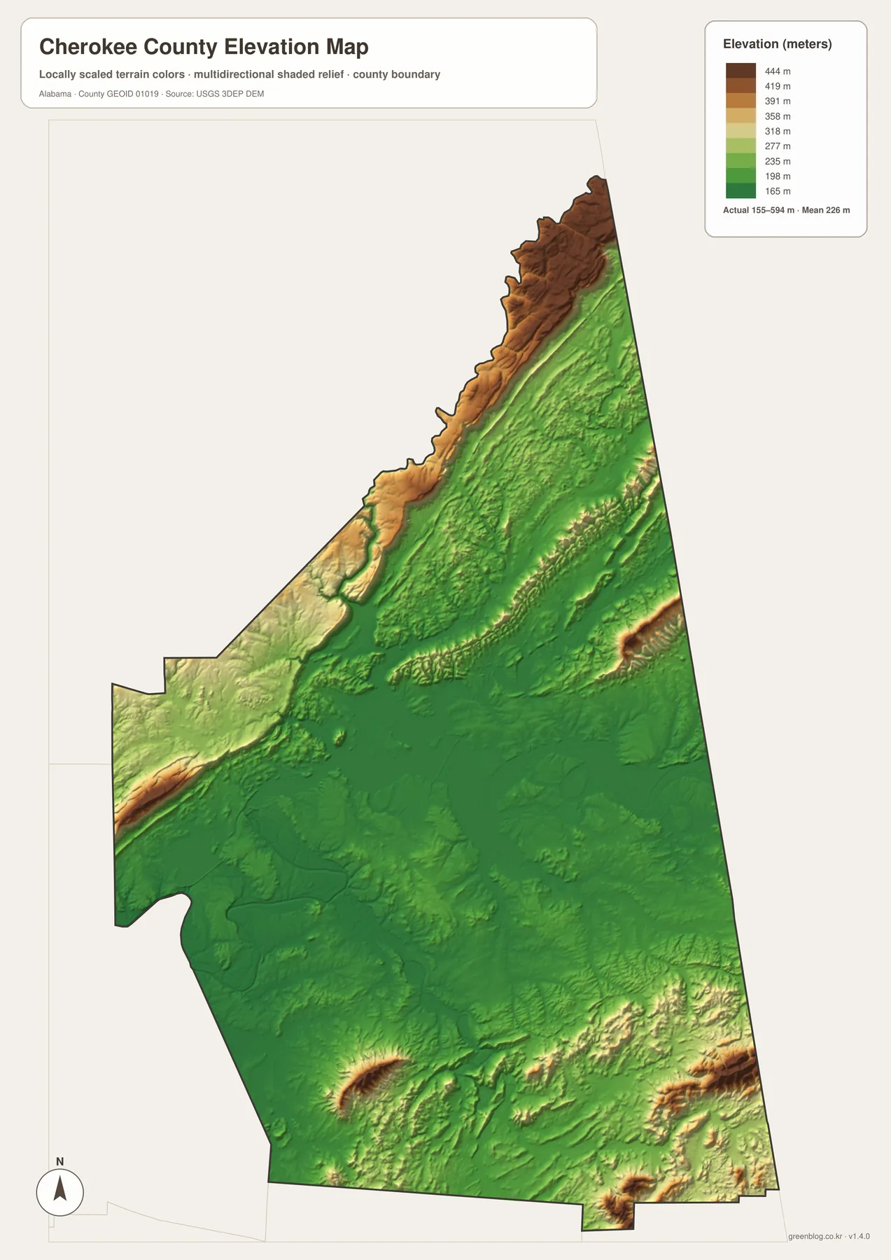
The shaded relief is intended for county-scale comparison. It is useful for recognizing broad differences in height and identifying ridge-and-valley patterns, but it is not a survey surface and should not be used to determine the exact elevation of an individual parcel or building site.
Choose the view that matches the question
If you are unfamiliar with Cherokee County, begin with the overview and locate Centre and Weiss Lake. Use the city map when relative community positions matter more than road detail. Switch to the water view when the shape of Weiss Lake, Little River, or smaller streams is the subject, and use the elevation map when you need to explain the transition from reservoir lowlands to the higher northeastern ridges.
- Orientation: find Centre, major roads, the county boundary, and Weiss Lake.
- Community placement: compare Leesburg, Cedar Bluff, Gaylesville, Sand Rock, and other mapped places.
- Water features: trace the reservoir arms, Little River, and smaller streams.
- Terrain: compare lower lake country with the higher ridge-and-valley landscape to the northeast.
Keeping these subjects separate makes the maps easier to use in classrooms and presentations. A road-and-settlement discussion can stay focused on the overview or city map, while a physical-geography lesson can place the water and elevation images together. The result is clearer than putting every road, stream, label, and terrain layer onto one crowded page.
Download the Cherokee County A3 JPG map files
The ZIP below contains high-resolution JPG versions of the county, city, water, and elevation maps. The WebP images in the article are optimized for quick browser viewing, while the larger JPG files are better suited to printing, handouts, posters, slide decks, and other offline uses.
Frequently Asked Questions
Why does Weiss Lake look so fragmented on the county map?
Weiss Lake is a reservoir with many arms, coves, and narrow channels extending into surrounding valleys. Its shoreline therefore appears much more complex than that of a compact natural lake.
Are the distances on the city map driving distances?
No. Connector distances are straight-line distances between mapped communities. Actual road travel can be longer because routes must follow available roads and crossings around Weiss Lake and the ridges.
What is included in the downloadable ZIP?
The ZIP contains four A3 high-resolution JPG files: a county reference map, a city map, a water map, and an elevation map.
Map File Information
Download Cherokee County maps for roads, communities, waterways, and terrain.
- Included Files: county map, city map, water map, elevation map
- File Type: high-resolution JPG files in one ZIP
- Intended Use: printing, education, presentations, and regional reference
Related Maps
More Alabama County Maps
- Along the Cahaba Valley: Bibb County Alabama Map
- Calhoun County Alabama Map
- Choctaw County Alabama Map
Sources and Reference Material
- Cherokee County Commission
- Outdoor Alabama: Weiss Lake
- National Park Service: Little River Canyon
- U.S. Census Bureau TIGER/Line
- USGS National Hydrography
- USGS 3D Elevation Program
Green Map creates custom-edited map images using open geographic data sources such as geoBoundaries, Natural Earth, OpenStreetMap, and government open data. These maps are edited visual materials, not raw data files, and are provided for education, documents, presentations, and graphic reference.