Barbour County sits in southeastern Alabama, where the eastern edge of the county meets Georgia along the Chattahoochee River and Walter F. George Reservoir. Eufaula is the largest city and the most prominent place on the eastern side, while Clayton, farther inland, serves as the county seat. This page brings those places together with roads, streams, lakes, and elevation so the county is easier to understand at a glance. The four maps shown below are also available as high-resolution landscape JPG files in one downloadable ZIP for A3 printing, classroom work, presentations, and personal map projects.
A single boundary map does not tell the whole story of Barbour County. The Chattahoochee side is shaped by a broad reservoir and lower river terrain, while the interior contains a dense network of small creeks, rolling ground, and scattered towns. The western and southwestern parts of the county rise noticeably above the low country near Eufaula. Looking at settlement, water, and terrain together makes it easier to see why the eastern edge feels different from the inland half of the county.
Table of Contents
Roads, Boundaries, and the Eufaula–Clayton Connection
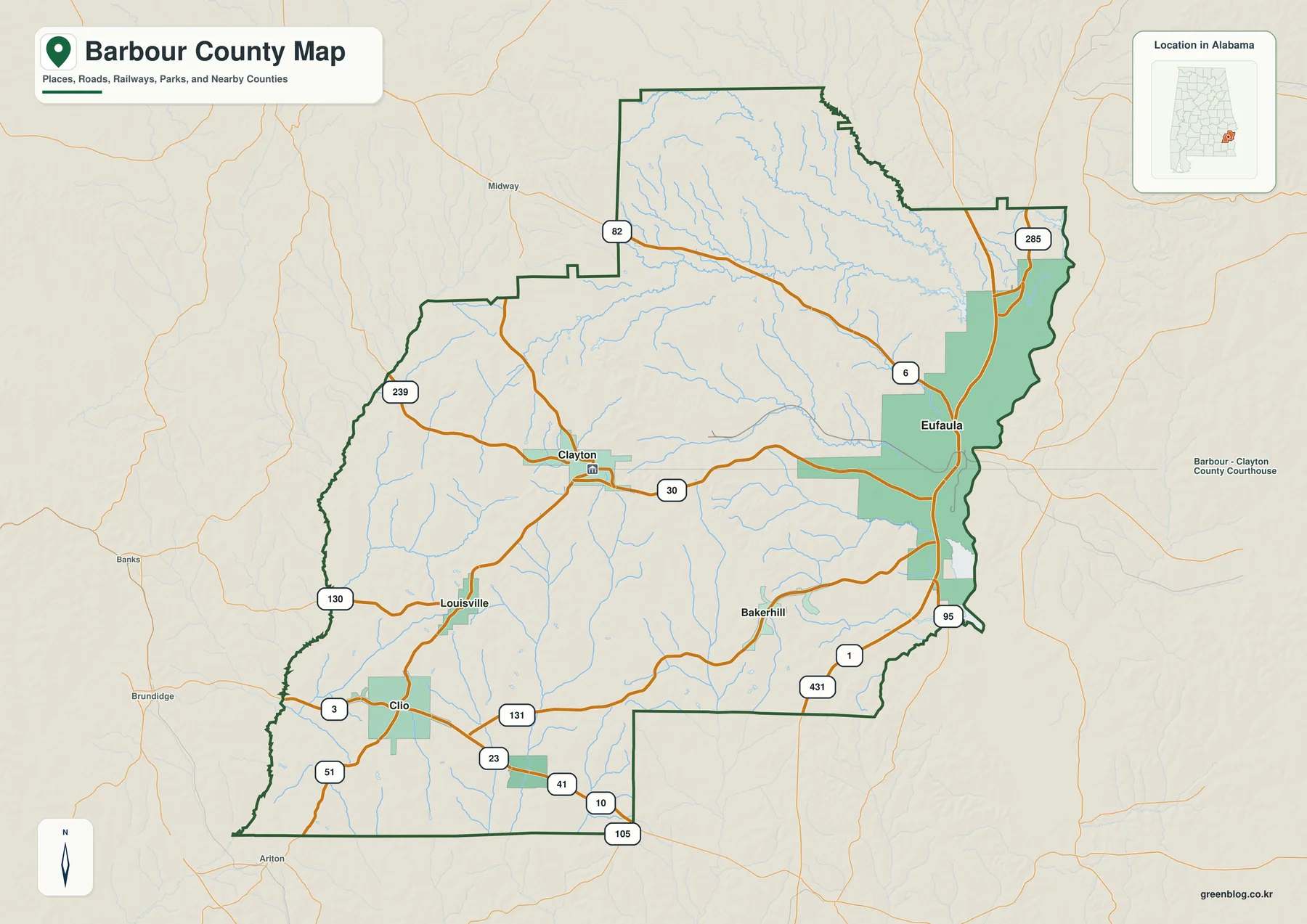
The basic county map is most useful when you begin with Eufaula and Clayton. Eufaula sits close to the eastern border, immediately beside the Chattahoochee River and Walter F. George Reservoir. Clayton is positioned well inland near the center of the county. That contrast explains an important feature of Barbour County: its largest city and its county seat are not the same place, and they occupy very different geographic settings.
US 82 provides a clear west-to-east reference line across the upper half of the county before reaching the Eufaula area. Alabama Route 30 links the Clayton area with the eastern side, while US 431 runs south from Eufaula and helps orient the southeastern part of the county. Farther south, state routes such as 131, 23, 41, and 51 help locate Clio, Louisville, Bakerhill, Blue Springs, and the rural areas between them. Instead of treating the road labels as a list, it is more useful to follow them as paths connecting the scattered communities.
The county outline itself is also worth noticing. Barbour County has several steps and bends rather than a simple rectangular shape, and the eastern boundary becomes especially irregular where it follows the river and reservoir area. Nearby county labels provide additional orientation: Bullock and Pike lie to the west, Russell is to the north, and Henry and Dale are toward the south. For navigation or current driving conditions, a live road map is still the better tool, but this map gives a strong overview of where places sit within the county.
Where Barbour County’s Six Mapped Cities Sit
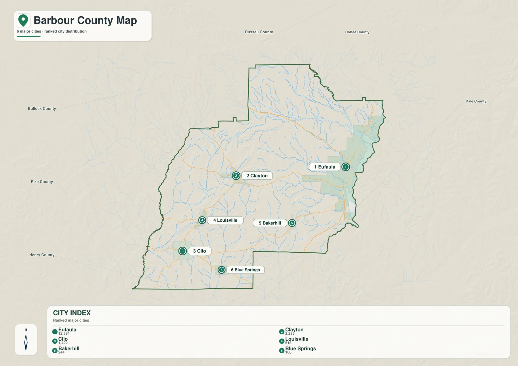
The city map strips away some of the visual detail and puts the emphasis on six communities: Eufaula, Clayton, Clio, Louisville, Bakerhill, and Blue Springs. Eufaula stands apart on the eastern side and is much larger than the other places shown. Clayton lies inland near the center, Louisville and Clio are grouped in the southwest, Bakerhill sits southeast of Clayton, and Blue Springs is close to the county’s southern edge. The distribution is broad enough that the county does not have one compact cluster of towns.
The population figures printed in the city index reinforce that pattern. Eufaula is clearly the dominant city among those mapped, but Clayton remains important because it is the county seat. This difference is useful when introducing the county to readers who might assume the largest city is automatically the administrative center. The smaller communities add another layer: they show how settlement follows several roads across the interior rather than concentrating only near the Chattahoochee.
The numbered markers are simply a visual index for the selected cities. They should not be read as highway numbers, travel stops, or a recommended route. For a presentation, this version works well after the general county map because it lets the viewer focus on settlement without having to sort through every road and stream at the same time. It is also useful for worksheets or local geography lessons where city placement matters more than transportation detail.
The Chattahoochee, Reservoir, and Interior Streams
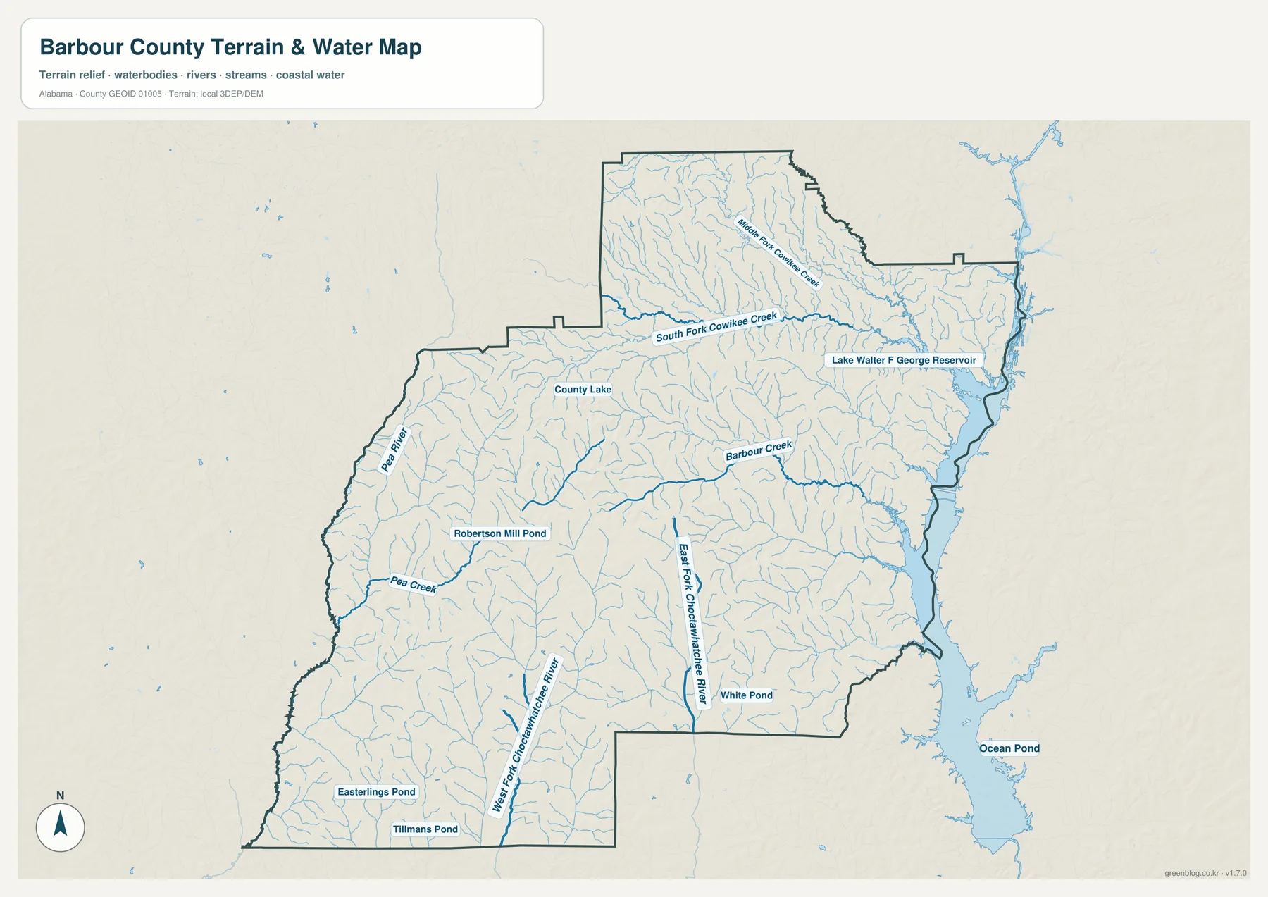
Water is one of the defining features of eastern Barbour County. Walter F. George Reservoir, commonly called Lake Eufaula in the local area, runs beside the county along the Chattahoochee River. Its broad surface makes the eastern boundary look very different from the mostly inland borders elsewhere. Eufaula sits directly beside this water, which is one reason the city is such a useful reference point on both the county and water maps.
Moving west from the reservoir reveals a much finer network of streams. Middle Fork Cowikee Creek and South Fork Cowikee Creek are labeled in the north, while Barbour Creek crosses the central-eastern part of the county. Pea River and Pea Creek appear on the western side. In the south, the East Fork and West Fork of the Choctawhatchee River show another drainage direction, separate from the streams that eventually reach the Chattahoochee side. County Lake, Robertson Mill Pond, White Pond, Easterlings Pond, and Tillmans Pond add smaller named water bodies to the map.
Those names are useful because they turn a background of thin blue lines into recognizable local features. The map is especially helpful when a reader wants to compare a road or town with a nearby stream, or when explaining why the county contains so many narrow valleys. It is not a flood-risk map, however, and it does not provide water depth or real-time conditions. Property-level flood questions should be checked with FEMA mapping and current local sources rather than inferred from the presence of a creek on this page.
Low River Country and the Higher Western Interior
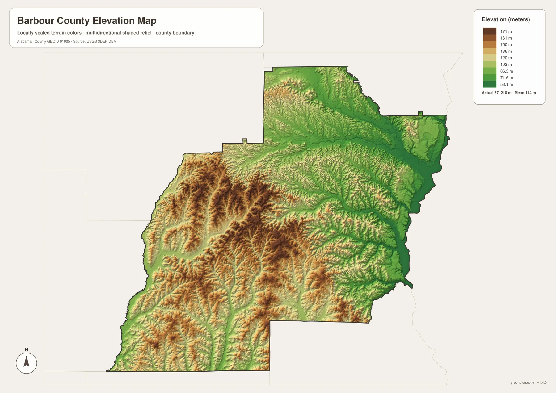
The elevation map adds a feature that is easy to miss on a standard road map. The eastern edge near the Chattahoochee and Walter F. George Reservoir is relatively low, while the interior rises into a more broken pattern of hills and shallow valleys. The western and southwestern sections contain many of the warmer, higher-elevation colors, whereas the river side is dominated by lower green shades. The legend shows an actual local range of roughly 57 to 210 meters, with an average near 114 meters.
This terrain helps explain the water map. Small streams begin or pass between the uplands, then follow lower valleys toward larger channels. On the east side, many drainage lines ultimately lead toward the Chattahoochee system; on the west and south, the Pea River and Choctawhatchee tributaries become important. The shaded relief makes the ridges visible without requiring the reader to interpret a dense set of contour lines, which is useful for general geography and classroom use.
The elevation sheet should still be treated as an overview rather than a surveying product. It cannot tell you the exact grade of a road, the elevation of a house lot, or whether a particular slope is suitable for construction. Its strength is comparison: it clearly shows that the county’s river edge and its western interior do not sit at the same height or have the same surface texture. That distinction is much harder to appreciate on the city map alone.
Choosing the Right Barbour County Map
For a general introduction, the county map is the best starting point because it keeps the boundary, roads, towns, and surrounding counties together. The city map is cleaner when the goal is to compare Eufaula, Clayton, and the smaller southern communities. The water map is the better choice for named creeks, rivers, ponds, and Walter F. George Reservoir, while the elevation map is most useful when the contrast between the low eastern edge and the hillier interior matters.
You can also combine the maps instead of choosing only one. A class presentation might begin with the county map, switch to the city sheet to discuss settlement, then use the water and elevation sheets to explain the natural landscape. A local history or travel handout may need only the first two. Because all four files use the same county boundary, it is easy to compare locations from one sheet to the next without learning a new layout each time.
The ZIP keeps each theme in its own image rather than combining everything into one crowded sheet. If you are printing, keep the original aspect ratio so road labels and place names stay readable. For digital use, cropping or scaling is usually fine as long as the map remains legible and the geographic context is not removed. The download is intended as a convenient map resource, not as a replacement for current navigation, legal boundary surveys, emergency mapping, or property-level analysis.
Frequently Asked Questions
Is Eufaula or Clayton the county seat?
Clayton is the county seat of Barbour County. Eufaula is the larger city and is located on the eastern side near the Chattahoochee River and Walter F. George Reservoir, so it is often the more visually prominent place on maps.
Are Lake Eufaula and Walter F. George Reservoir the same body of water?
Walter F. George Reservoir is commonly known as Lake Eufaula in this area. On the map it appears along Barbour County’s eastern edge beside Eufaula and the Georgia border.
Can the water and elevation maps be used to determine flood risk?
They can help you understand where major water bodies and lower terrain are located, but they are not property-level flood maps. Use FEMA flood mapping, current local information, and professional survey data when a precise risk determination is needed.
What files are included in the download?
The ZIP contains four landscape JPG files: a general county map, a city map, a water map, and an elevation map. Each image is 3638 × 2572 pixels and is suitable for A3 printing as well as classroom, presentation, and personal map use.
Map File Information
The download package contains the county, city, water, and elevation maps as separate high-resolution landscape JPG files. They are larger than the web previews and sized for A3 printing, so you can use one map by itself or place several together in a report, lesson, or presentation.
- Included Files: 4 high-resolution landscape JPG maps
- Printable Size: 3638 × 2572 pixels
- Intended Use: A3 printing, education, presentations, and map projects
Related Maps
- Baldwin County Alabama Map
- Bibb County Alabama map
- Bullock County Alabama map
- Alabama Population Density Map: Urban Clusters, County Totals and a Decade of Change
- Barbour County Alabama Land Cover Map – Forest Cover, Farm Patches & Eufaula River Edge
Barbour County Sources and Useful Links
- U.S. Census Bureau QuickFacts — Barbour County statistics
- Barbour County Commission — county government information
- Alabama Department of Transportation — Barbour County highway classification
- U.S. Fish and Wildlife Service — Eufaula National Wildlife Refuge
- Alabama State Parks — Blue Springs State Park
Green Map creates custom-edited map images using open geographic data sources such as geoBoundaries, Natural Earth, OpenStreetMap, and government open data. These maps are edited visual materials, not raw data files, and are provided for education, documents, presentations, and graphic reference.