Chambers County in eastern Alabama has a geography that is easier to understand once its two different centers are separated. LaFayette sits inland as the county seat, while Valley and Lanett form a much tighter cluster near the Georgia state line. The Tallapoosa River system lies to the west, West Point Reservoir and the Chattahoochee River define the eastern water setting, and a belt of higher rolling ground runs through the county between them. This page includes road, city, water, and elevation previews, along with a downloadable ZIP of high-resolution A3 JPG files for printing, lessons, presentations, and general map reference.
A simple way to orient yourself is to locate LaFayette first and then look east toward Valley and Lanett. From the county seat, Five Points is farther north, Cusseta lies to the south, and Waverly sits near the southwestern edge. Once those places are fixed in mind, the water and elevation maps become easier to interpret because the eastern reservoir shoreline, western river corridor, and higher central terrain all fall into a clear geographic pattern.
Table of Contents
LaFayette, the eastern corridor, and the county boundary
The county overview shows a strong contrast between inland LaFayette and the Valley–Lanett area near Georgia. Roads spread from the county-seat area toward the east and also connect smaller communities in the north and south. Because the most visible urban concentration is not centered on LaFayette, a standard geometric idea of the county “center” can be misleading for visitors who are trying to understand where people and roads are concentrated.
The eastern boundary is visually more complicated than much of the north and west. Near the Chattahoochee system and West Point Reservoir, the county edge bends around an irregular water setting. Smaller names such as Five Points, Cusseta, Waverly, Penton, Fredonia, and Huguley provide useful reference points when moving away from the better-known eastern cities.
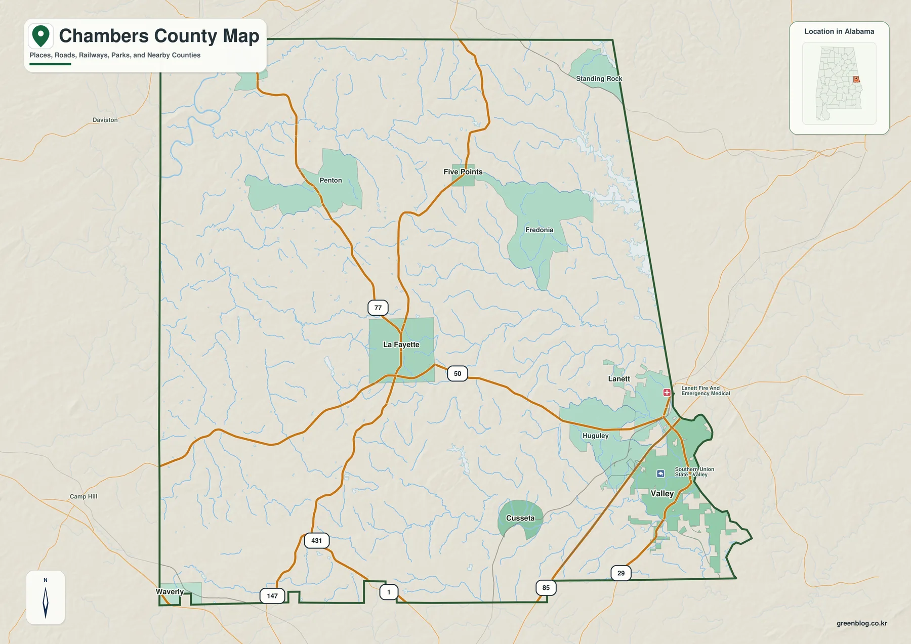
This overview is intended for orientation rather than turn-by-turn travel. It is useful for identifying where a community sits within Chambers County and which major corridors connect different parts of the county, but current driving distances and road conditions should be checked with a navigation or transportation source.
Valley and Lanett form the clearest eastern city cluster
The city-focused view makes the settlement pattern much easier to compare. Valley and Lanett sit close together near the state line, while LaFayette is farther inland. Waverly reaches toward the southwest, Five Points marks the northern part of the county, and Cusseta adds a southern interior reference. Looking at all six locations prevents the eastern urban area from making the rest of the county seem smaller than it really is.
Connector lines on the city graphic are meant to show direction and relative spacing. They are not road routes and should not be read as driving mileage. Actual trips can be longer because roads curve, intersections change the route, and bridges or access points may limit the most direct path between two places.
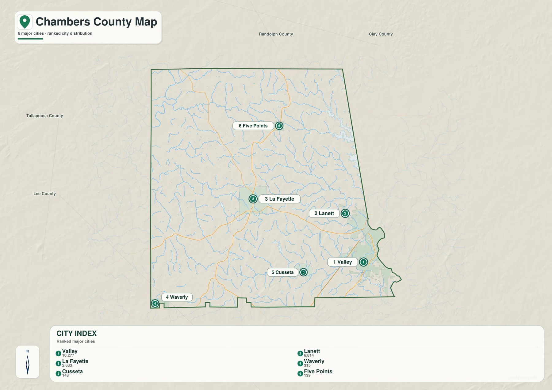
For classroom or presentation use, this simplified map is especially helpful because the east–west contrast is visible without the distraction of every road and water label. It also makes the distinction between the administrative center at LaFayette and the more concentrated eastern urban area easy to explain.
Water drains toward major systems on both sides of the county
Chambers County lies between two large river settings. The Tallapoosa River is the dominant western reference, while West Point Reservoir and the Chattahoochee River shape the east. Between those edges, a dense collection of smaller creeks and local water bodies crosses the interior, giving the county a more complex drainage pattern than the road map alone suggests.
Chikasanookee Creek in the north, Allen Creek in the western interior, Channasoppe Creek farther south, and Osanippa Creek toward the southeast provide useful named checkpoints. Phillips Lake, Grady Lake, LaFayette City Lake, Chambers County State Lake, and Jones Mill Pond add smaller water features that help identify local areas. The branching shoreline of West Point Reservoir is particularly distinctive compared with the clearer river course on the western side.
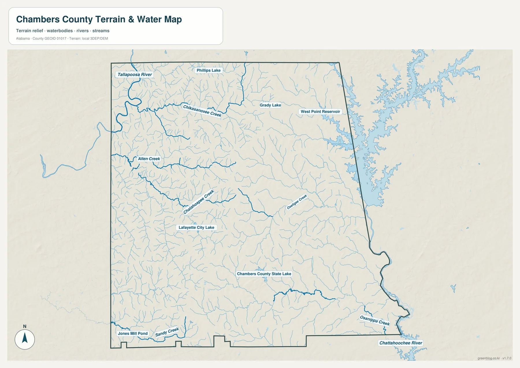
The map is a geographic reference for visible waterways, not a flood-insurance or legal-boundary product. Flood zones, regulated shorelines, boating restrictions, parcel limits, and current water levels require information from the appropriate official agencies.
Higher central ground separates lower river valleys
The elevation view reveals a broad belt of higher rolling terrain through the central part of Chambers County. Brown and tan colors mark the more elevated ridges, while greener tones spread through lower valleys toward both major river systems. The pattern explains why a political map can make the county look flatter and simpler than the terrain actually is.
The displayed legend emphasizes local differences, with its main color steps running roughly from 180 to 257 meters. That county-scale range makes subtle ridges and valleys easier to distinguish than a broad statewide scale would. When the elevation and water maps are compared, many small streams can be seen following lower corridors between higher areas, though not every visible valley corresponds to a named creek.
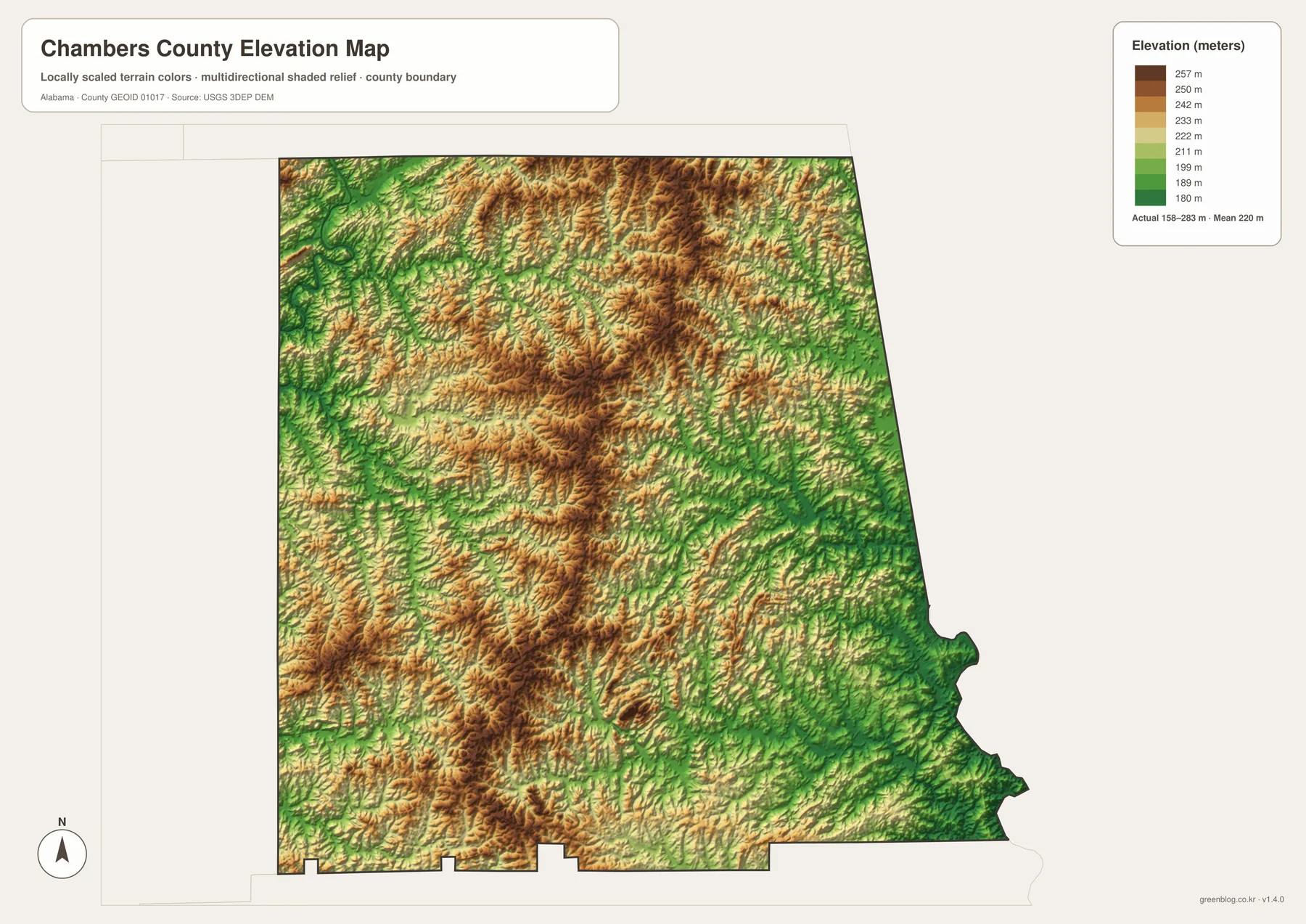
The relief has been simplified for county-wide comparison. It is useful for seeing broad changes in height and the relationship between ridges and valleys, but it is not a survey surface and should not be used to determine the precise elevation of an individual property or structure.
Pick the map that matches the information you need
Start with the county overview when you need roads, communities, and the state boundary in one image. Use the city view when relative location is more important than road detail. The water map is the clearest option for tracing the Tallapoosa River, West Point Reservoir, Chattahoochee River, and smaller creeks, while the elevation map is best for explaining the central uplands and the lower valleys on either side.
- Orientation: locate LaFayette, Valley, Lanett, nearby communities, and major roads.
- Settlement pattern: compare the eastern city cluster with smaller places across the county.
- Water features: follow major rivers, the reservoir shoreline, creeks, lakes, and ponds.
- Terrain: compare higher central ridges with lower drainage corridors to the east and west.
Keeping these subjects on separate maps also makes printed pages and presentation slides easier to read. A lesson on cities does not need the full water network, while a terrain discussion benefits from the specialized elevation view. When comparison is the goal, two relevant images can be placed side by side without forcing every label onto one crowded map.
Download the Chambers County A3 JPG map files
The ZIP below includes high-resolution JPG versions of the county, city, water, and elevation maps. The WebP previews on this page are convenient for browser viewing, while the larger JPG files are better suited to printing, classroom handouts, posters, and presentation slides.
Frequently Asked Questions
Why do Valley and Lanett stand out on a Chambers County map?
They sit close together near the Georgia boundary and form the county’s most obvious eastern urban cluster. LaFayette, the county seat, is farther inland, so the contrast between the administrative center and the eastern population center is easy to recognize.
Does the water map show flood zones or legal water boundaries?
No. It is designed to show rivers, reservoirs, lakes, creeks, and general terrain context. Flood zones, regulated shorelines, parcel boundaries, and navigation rules should be checked with current official sources.
What is included in the downloadable Chambers County map ZIP?
The ZIP contains four high-resolution A3 landscape JPG files: the county map, city map, water map, and elevation map. Each image is 3638 × 2572 pixels.
Map File Information
Download the Chambers County map set for roads, cities, waterways, and terrain.
- Included Files: county map, city map, water map, elevation map
- File Type: high-resolution JPG files packaged in one ZIP
- Intended Use: printing, classrooms, presentations, and regional reference
Related Maps
More Alabama County Maps
Sources and references
- Chambers County official website
- Encyclopedia of Alabama: Chambers County
- U.S. Census Bureau QuickFacts for Chambers County
- Alabama DOT Chambers County functional-classification map
- USGS National Hydrography
- USGS 3D Elevation Program
Green Map creates custom-edited map images using open geographic data sources such as geoBoundaries, Natural Earth, OpenStreetMap, and government open data. These maps are edited visual materials, not raw data files, and are provided for education, documents, presentations, and graphic reference.