Download four high-resolution A3 JPG maps of Baldwin County in one ZIP, covering the county outline and roads, major cities, waterways, and elevation. Baldwin County stretches from inland rivers in southwest Alabama to the Gulf Coast. The set covers the county outline and roads, major cities, waterways, and elevation so readers can move from Bay Minette and Mobile Bay to Foley, Gulf Shores, and Orange Beach without losing the larger county context. Bay Minette, the county seat, is in the north-central part of the county, while Daphne, Fairhope, and Spanish Fort are clustered along the eastern side of Mobile Bay. Farther south, Foley sits inland from the coast and Gulf Shores and Orange Beach occupy the coastal end near the Gulf of Mexico.
The county’s shape makes orientation especially important. Mobile Bay forms a major western reference, Florida lies to the east, and the coastline stretches across the south. The northern part reaches far beyond the beach communities, with Bay Minette and a dense network of rivers and tributaries well inland. As you move south, settlement becomes more concentrated around the Mobile Bay side and the Gulf Coast, while elevation generally drops toward low coastal ground. Reading the county through places first—and then using roads, water, and terrain to explain those places—gives the page a more useful flow than treating the maps as four separate products.
Table of Contents
Bay Minette, Major Roads, and the Long County Shape
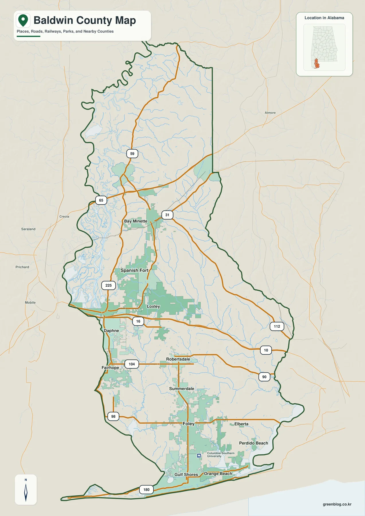
Bay Minette provides the clearest inland starting point on the reference map. U.S. 31 and U.S. 59 meet the broader road network around the county seat, while routes continue south toward Spanish Fort, Loxley, Robertsdale, and Foley. Along the western side, Daphne and Fairhope sit close to Mobile Bay and connect with roads such as U.S. 98 and Alabama 104. Farther south, Alabama 59 leads from the Foley area toward Gulf Shores, and Alabama 180 follows the coast toward the long Fort Morgan peninsula. These roads make the county’s elongated shape easier to understand because they connect inland communities with the bay and beach corridor.
The boundary itself changes character several times. In the northwest, it follows a winding area associated with the Alabama and Mobile river systems. The central western side faces Mobile Bay, while the east extends toward the Florida state line. Near the southeast, the Perdido side and coastal waters create another irregular edge. The southern boundary is the most distinctive part of the county outline: a narrow barrier-like coastal strip, bays, lagoons, and the Fort Morgan peninsula contrast sharply with the broad inland interior.
The road layer is selective rather than a replacement for a navigation service. It is designed to show the highways and communities that help a reader understand county-scale geography. For actual driving, current traffic, or a specific address, a live road map is more appropriate. Here, the useful questions are broader: where Bay Minette sits relative to the coast, how the Mobile Bay cities line up, how Foley connects the inland south with the beach communities, and how the county reaches east toward Florida.
Cities Concentrated along Mobile Bay and the Gulf Side
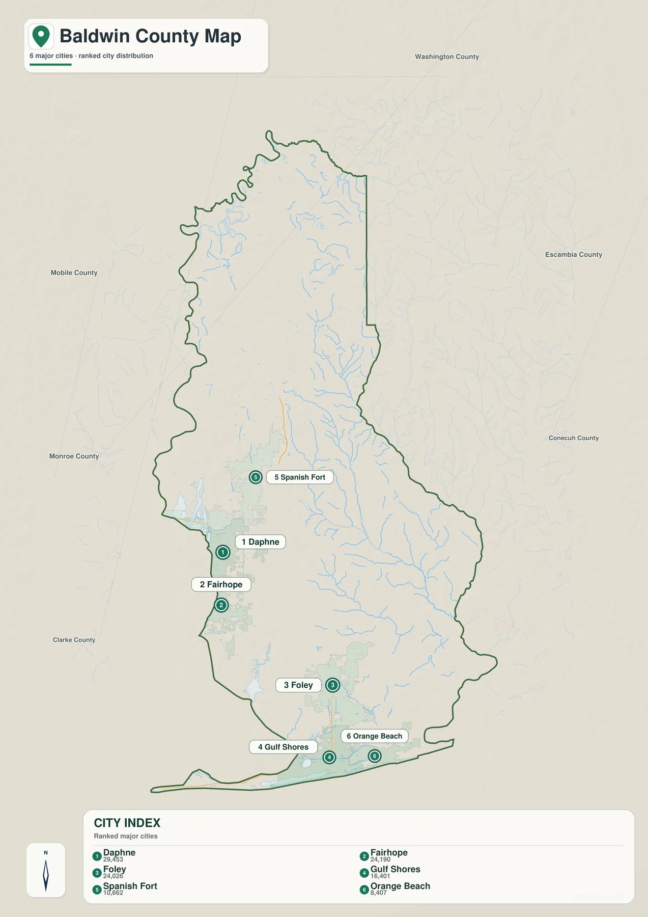
The city view highlights Daphne, Fairhope, Foley, Gulf Shores, Spanish Fort, and Orange Beach. Their distribution is more informative than the ranking alone. Spanish Fort, Daphne, and Fairhope form a north-to-south group close to the eastern shore of Mobile Bay. Foley lies farther south but inland from the Gulf, while Gulf Shores and Orange Beach sit near the coast. The map leaves much of northern Baldwin County without a highlighted major-city marker, reinforcing how different the settlement pattern is between the inland north and the more urbanized bay and coastal areas.
The city index printed on the map lists Daphne at 29,453, Fairhope at 24,190, Foley at 24,026, Gulf Shores at 16,401, Spanish Fort at 10,662, and Orange Beach at 8,407. Those figures should be treated as the values used for this map’s ranked city display, not as a promise of the latest population estimate. Population changes over time, and current figures should be checked with an official statistical source when they matter. For map reading, the key point is that the selected population centers are concentrated in the southwestern and southern parts of the county.
This distribution also helps explain why Bay Minette can feel geographically separate from the better-known beach communities. The county seat is farther north, while the most visible concentration of highlighted cities lies closer to Mobile Bay and the Gulf. A reader who knows Baldwin County mainly through Gulf Shores or Orange Beach may underestimate how far the county extends inland. Moving back to the reference map after viewing the city distribution makes that distance much more apparent.
Mobile Bay, Northern Rivers, and the Perdido Side
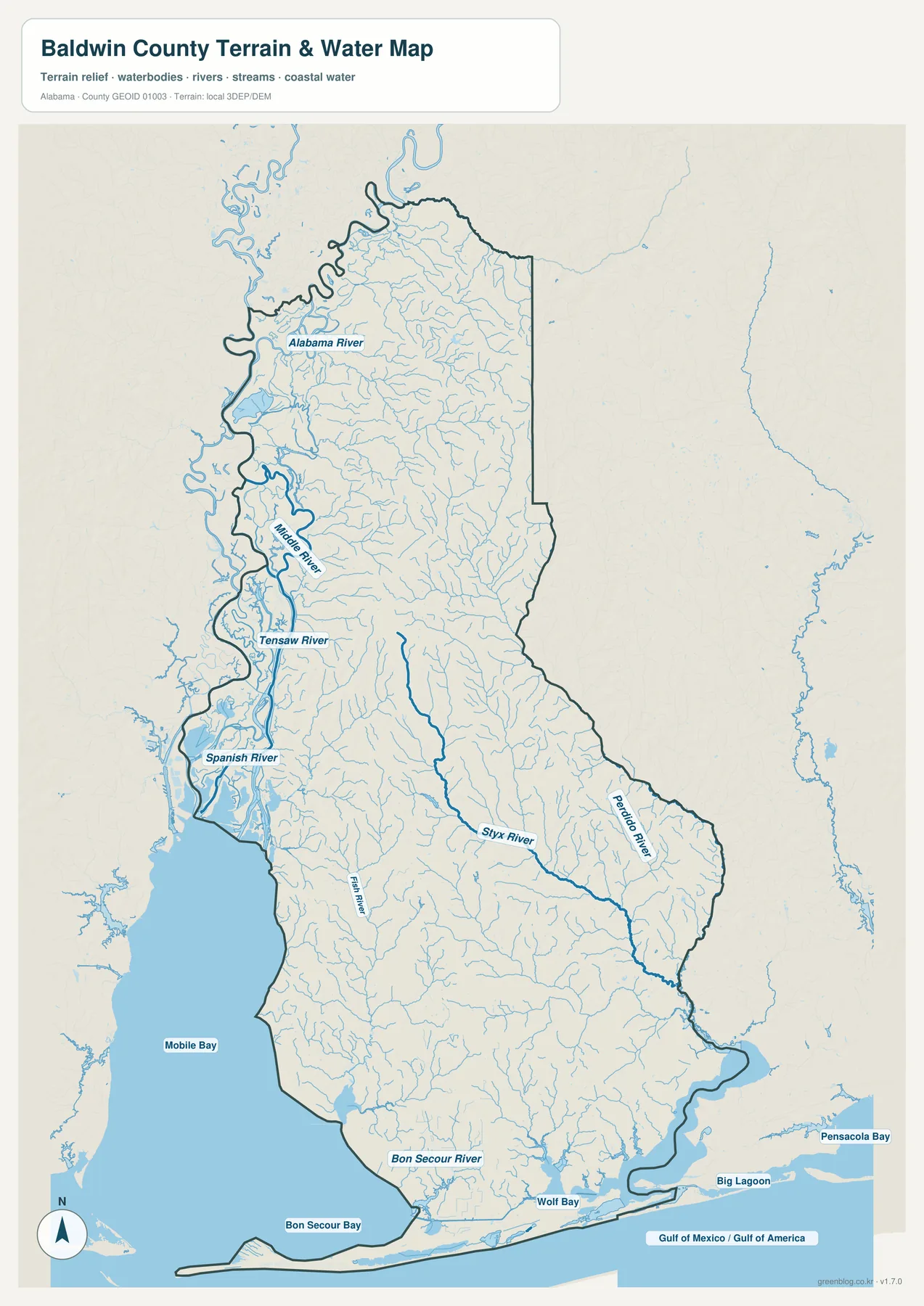
Water defines much of Baldwin County’s geography. In the northwest, the Alabama River approaches a complex network that includes the Mobile River, Tensaw River, Spanish River, and numerous smaller channels. These waterways spread toward Mobile Bay and create a much more intricate pattern than the simple county outline suggests. The western edge then opens onto Mobile Bay, which remains one of the strongest reference features all the way south toward the coastal portion of the county.
Farther east, the Styx River crosses the interior and the Perdido River runs near the Alabama–Florida side before reaching coastal waters. Fish River drains part of the central and southern county, while Bon Secour River enters the bay of the same name near the Gulf Coast. The map also labels Wolf Bay, Big Lagoon, Bon Secour Bay, and the direction of Pensacola Bay. Together, these features show that Baldwin County is not bordered by water only at the beach; rivers, bays, tributaries, and estuarine water are important from the northern boundary to the Gulf.
This water map is intended for geographic reference, not flood determination or navigation. It does not show regulatory flood zones, current river stages, tidal conditions, safe boating channels, water depth, or property boundaries. Those questions require current information from the appropriate agencies. For county-scale study, however, the map is especially useful for understanding why the northwest boundary is so irregular, how Mobile Bay relates to the cities on its eastern shore, and how the Perdido side connects Baldwin County to the Florida border.
Higher Northeastern Interior and the Low Gulf Coast
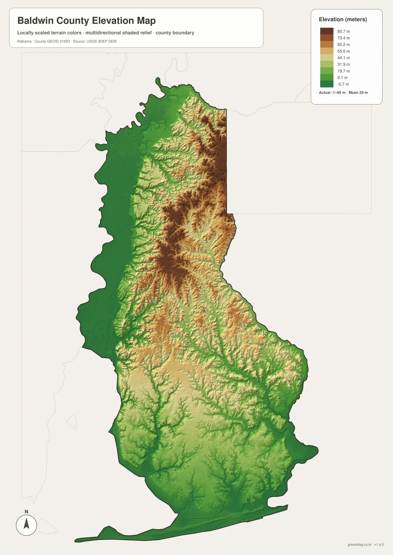
The elevation map adds a feature that is easy to miss on a road map: Baldwin County is not uniformly flat. The displayed data show an actual range of about -1 to 99 meters, with an average near 29 meters. Higher brown and tan terrain is most noticeable in the northeastern and north-central interior, where narrow valleys cut through a more strongly ridged surface. The western water side and the southern coastal zone are generally greener, indicating lower elevations.
The transition is gradual rather than a single sharp line. Northern and northeastern uplands are crossed by lower stream valleys, and central Baldwin County contains a mixture of ridges and lower corridors. Moving toward Mobile Bay and the Gulf, the land becomes lower overall and the relief is less pronounced. Around the beach communities and narrow coastal strip, the terrain is especially low. Comparing this view with the water map makes the relationship intuitive: many streams follow lower corridors between higher areas before reaching rivers, bays, or the Gulf.
A county-scale elevation surface is useful for explaining broad terrain differences, but it is not survey-grade data. It should not be used to determine a parcel elevation, construction slope, drainage design, or the safety of a coastal site. Small height differences can be very important near the coast, so precise decisions require detailed elevation and flood information. On this page, the map works best as a visual explanation of why the northern interior looks more textured and why the southern coast appears broad, low, and flat.
Using the Maps for Printing, Classrooms, and Presentations
The most useful map depends on the question, not on a fixed order. A county overview works well when the goal is to place Bay Minette, the Mobile Bay communities, Foley, and the coast on the same page. When the discussion turns to settlement, the simplified city distribution makes the southwest concentration easier to see. A lesson about rivers can focus on the northern channels, Mobile Bay, and the Perdido side, while a terrain discussion can use the elevation colors to compare inland ridges with low coastal ground. This approach keeps the maps tied to real geographic questions instead of presenting them as a repetitive list of versions.
For a presentation, one effective route is to follow the county from north to south. Begin at Bay Minette, move toward Spanish Fort, Daphne, and Fairhope along the Mobile Bay side, then continue through Foley to Gulf Shores and Orange Beach. Water features can be introduced along the same path, from the northern river network to Mobile Bay and the Gulf. The terrain view then explains why the interior and the coast look different. Because each new image answers a question raised by the previous one, the sequence feels connected rather than mechanical.
The downloadable originals are 2572 × 3638 pixel JPG files prepared in A3 portrait orientation. The WebP previews are convenient for browsing the page, while the larger JPG files are better suited to printing, full-page handouts, and slides where labels need to remain readable. Before printing, check that the document is set to portrait orientation and that automatic scaling does not crop the county boundary or legends. Small river labels and terrain details are easier to read when one map is given adequate page space.
These maps are appropriate for general geographic reference, education, reports, travel orientation, and local presentations, but their scale matters. A current navigation service is better for turn-by-turn driving. Flood and tidal decisions require current official hazard information, and property or engineering work requires detailed survey and elevation data. Used within those limits, the set provides a clear picture of Baldwin County as a long coastal county shaped by Mobile Bay, inland river systems, a concentration of southern cities, and a noticeable drop in elevation toward the Gulf.
Frequently Asked Questions
What do the numbered markers on the Baldwin County city map mean?
They connect the highlighted markers with the city index for Daphne, Fairhope, Foley, Gulf Shores, Spanish Fort, and Orange Beach. The numbers are a location key, not a travel sequence or an official ranking of the cities.
Can the Baldwin County water map show current flood risk?
No. It is a county-scale reference for rivers, bays, tributaries, and coastal water. Regulatory flood zones, current river levels, tides, evacuation decisions, and property-specific risk should be checked with current official hazard information.
Is the Baldwin County elevation map suitable for surveying or engineering work?
No. The map summarizes broad elevation differences across the county. Exact parcel heights, construction grades, drainage plans, and engineering measurements require detailed source data and professional surveying.
What files are included in the Baldwin County map download?
The ZIP contains four high-resolution A3 portrait JPG files covering the county, cities, water, and elevation. Each image measures 2572 × 3638 pixels and is intended for larger viewing, printing, and document use.
Map File Information
Baldwin County Four-Map JPG Set · A3 portrait · 2572 × 3638 px · 4 JPG files in one ZIP
- Included Files: County, city, water, and elevation maps
- File Type: High-resolution JPG files in one ZIP archive
- Intended Use: Printing, education, presentations, and map-based projects
Related Maps
- Brazoria County Texas map | Angleton and Gulf of Mexico coast
- Barbour County Alabama map
- Bibb County Alabama map
Baldwin County Map Sources
The following official and public sources are useful when you need more detail about boundaries, roads, waterways, elevation, or local background. The maps on this page are simplified for county-scale reading, so the original sources are the better choice for current official data and specialized questions.
- U.S. Census Bureau TIGER/Line — county and place boundaries
- Baldwin County Commission — county overview
- Baldwin County Highway Department — county road information
- USGS National Hydrography — rivers, streams, and water bodies
- USGS 3D Elevation Program — elevation data
- U.S. Fish and Wildlife Service — Bon Secour National Wildlife Refuge
- Alabama Population Density Map: Urban Clusters, County Totals and a Decade of Change
Green Map creates custom-edited map images using open geographic data sources such as geoBoundaries, Natural Earth, OpenStreetMap, and government open data.
These maps are edited visual materials, not raw data files, and are provided for education, documents, presentations, and graphic reference.