Download the Lowndes County Alabama Map files on this page as four high-resolution A3 JPGs covering the county road network, incorporated communities, rivers and creeks, and elevation. The set is designed for readers who need more than a single location map: one sheet gives regional orientation, another isolates the six incorporated communities, the water map brings small streams into view, and the elevation map shows the sharp difference between the low Alabama River side and higher ground in the south.
Lowndes County lies in south-central Alabama’s Black Belt between the Selma and Montgomery regions. Hayneville is the county seat near the center-east, U.S. 80 crosses the northern part of the county on the Selma–Montgomery route, and Fort Deposit sits near the southeastern I-65 and U.S. 31 corridor. White Hall and Lowndesboro are farther north, closer to the Alabama River landscape. Those places are small, but their positions relative to the highways, river, and rural interior make the county much easier to understand on a map than from a simple list of towns.
Table of Contents
Hayneville, U.S. 80, and the county road pattern
The general county map is the best starting point because it places the county boundary, main highways, communities, waterways, and neighboring counties on one page. Hayneville sits a little east of the county’s center, with Mosses and Gordonville to the west. White Hall and Lowndesboro occupy the northern half, while Fort Deposit is separated from them by a long stretch of rural country and appears close to the southern edge.
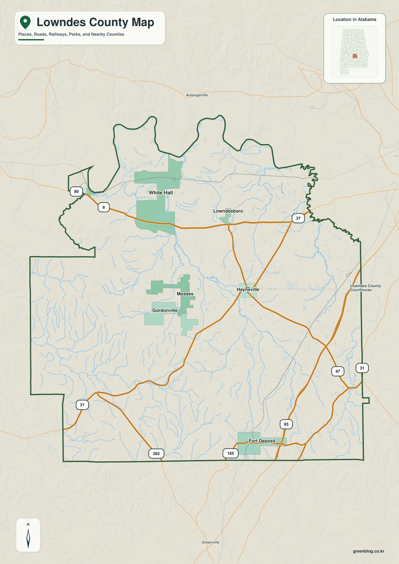
U.S. 80 is the most obvious east-west route. It enters from the Selma side, passes the White Hall area, and continues toward Montgomery. I-65 and U.S. 31 serve a different part of the county, running along the eastern and southeastern side near Fort Deposit. Hayneville is important as the government center, but it is not an interstate town. That distinction matters when estimating travel direction: U.S. 80 is the clearer route toward Selma, while Fort Deposit is better positioned for direct interstate travel toward Montgomery and south Alabama.
The map also labels Autauga, Montgomery, Wilcox, Crenshaw, Dallas, and Butler counties around Lowndes County. The northern outline is irregular near the Alabama River side, while long rural boundaries frame much of the west and south. For quick orientation, it helps to locate three reference points first: Hayneville near the middle, U.S. 80 across the north, and Fort Deposit near the I-65 corridor. Once those are in place, White Hall, Lowndesboro, Mosses, and Gordonville are much easier to position.
| State | Alabama |
|---|---|
| County | Lowndes County |
| County seat | Hayneville |
| 2025 population estimate | 9,359 |
| 2020 census population | 10,311 |
| Land area | 716.09 sq mi |
| 2020 population density | 14.4 per sq mi |
| Main routes | I-65, U.S. 80, U.S. 31 |
The Census material included in the package gives a July 1, 2025 population estimate of 9,359 and a 2020 census count of 10,311. With 716.09 square miles of land and a 2020 density of only 14.4 people per square mile, Lowndes County is very lightly settled. The same source material lists a 2020–2024 mean commute of 31.4 minutes. Those numbers fit what the map shows: local services and named communities are widely separated, and regional access to Montgomery or Selma often matters as much as travel between towns inside the county.
Six incorporated communities spread across the rural interior
The city map removes much of the road detail and emphasizes Fort Deposit, White Hall, Mosses, Hayneville, Gordonville, and Lowndesboro. The six places do not form one continuous urban area. Instead, they mark different parts of a large rural county: Fort Deposit in the south, White Hall and Lowndesboro in the north, Hayneville toward the center-east, and Mosses and Gordonville across the interior.
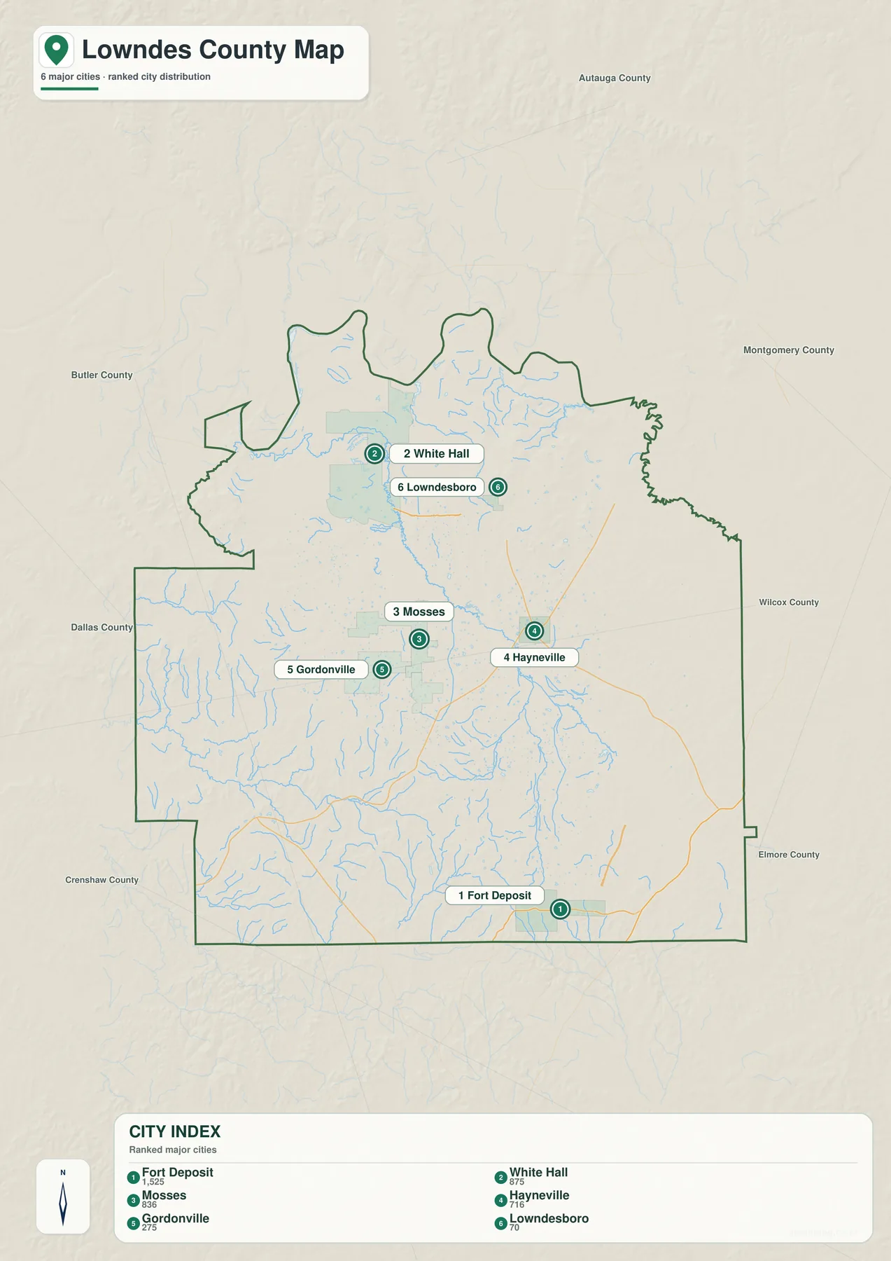
Hayneville has been the county seat since Lowndes County was created in 1830. The courthouse in use today is based on the Greek Revival building constructed in 1856, so the town’s government role is much larger than its population alone would suggest. Fort Deposit has a different setting. It is the largest incorporated community in the source material and lies much closer to I-65 and U.S. 31, giving the southeastern corner of the county a stronger connection to long-distance highway travel.
White Hall is important because its location overlaps with the U.S. 80 civil-rights corridor. The National Park Service operates the Lowndes Interpretive Center there, covering the 1965 Selma-to-Montgomery voting-rights marches, the local voting-rights movement, and Tent City. Lowndesboro, farther north, represents an older Black Belt settlement pattern tied to cotton agriculture and access toward the Alabama River. Its historical role is therefore more river-oriented than Fort Deposit’s highway-oriented position.
Mosses and Gordonville are useful map anchors for the broad central and western countryside. Mosses lies between the better-known Hayneville and White Hall areas, while Gordonville provides a western interior reference point. On a county with low population density, these small place names are valuable because they help a reader divide a large blank-looking rural area into recognizable sections without overstating the size of any town.
Alabama River, creeks, ponds, and wet lowlands
The water map changes the way Lowndes County looks. The Alabama River is the dominant named feature near the northern side, but dozens of smaller streams fill the interior. Separating those waterways from the road layer makes the county’s valleys, wet lowlands, and drainage routes much more visible, especially in areas where few towns are labeled.
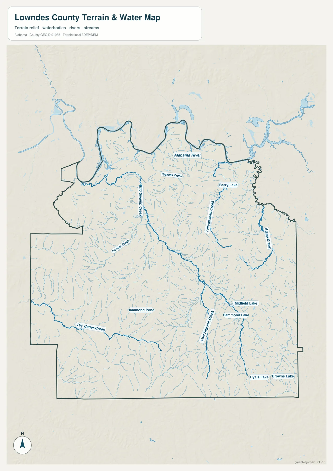
Cypress Creek and Big Swamp Creek stand out in the northern and west-central area. Tallawassee Creek and Sipeo Creek form long, distinct water lines on the eastern side, while Panther Creek appears farther west. Dry Cedar Creek crosses the southwest, and Fort Deposit Creek runs through the south-central part of the county. The sheet also labels smaller water bodies including Berry Lake, Hammond Pond, Middlefield Lake, Hammond Lake, Ryals Lake, and Browns Lake. These features make the water map useful for anyone who needs more local detail than the general road sheet provides.
The northwestern river country also has a strong natural-landscape identity. The attached Outdoor Alabama material describes the 15,920-acre Lowndes Wildlife Management Area near White Hall along the Alabama River. Its habitats include river-bottom hardwoods, swamp drainages, old fields, and mixed pine-hardwood stands. Seeing the dense creek network around the river side helps explain why this part of Lowndes County looks and functions differently from the drier interstate-oriented southeast.
Elevation from about 26 to 179 meters
The elevation map shows an actual range of roughly 26 to 179 meters, with a mean near 79 meters. The lowest ground appears in dark green near the Alabama River and in major stream valleys. Higher terrain becomes much more common toward the south, where yellow, tan, and brown shading follows broad ridges along and near the county boundary.
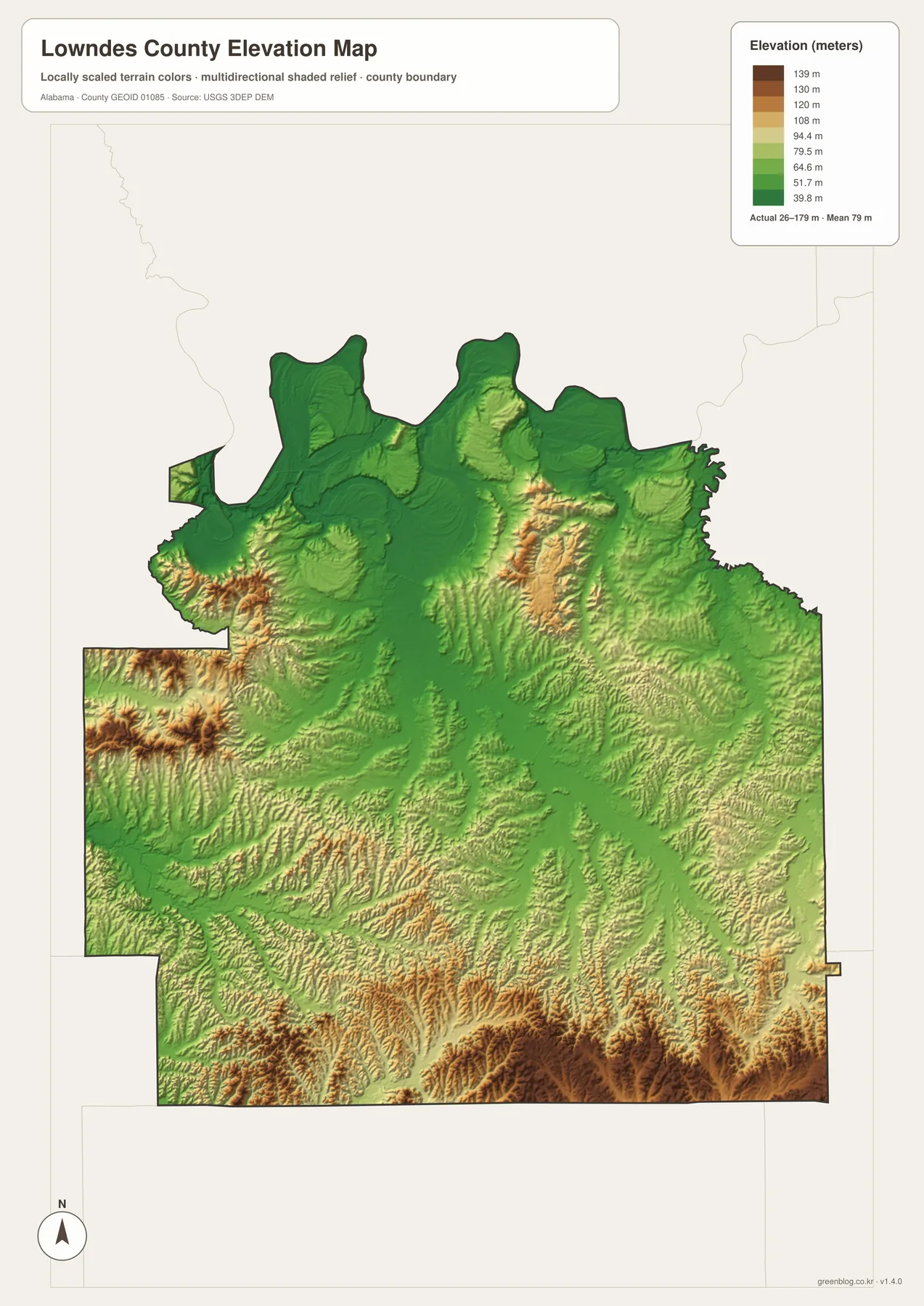
The pattern is not a simple north-to-south slope. Several higher ridges also appear in the northwest and northeast, while stream valleys cut lower routes through the center. Comparing the elevation sheet with the water map makes those details easier to understand. Big Swamp Creek, Tallawassee Creek, Fort Deposit Creek, and other streams occupy lower corridors between surrounding ridges, eventually connecting the interior with larger waterways.
This terrain view is useful even for readers who do not work with GIS data. The general county map answers where a town or highway is located; the elevation map answers why the ground around one part of the county looks flatter or more broken than another. The difference is especially clear when comparing the low Alabama River side with the higher southern edge below Hayneville and around the Fort Deposit area.
Black Belt land, river history, and the U.S. 80 civil-rights corridor
Lowndes County was created on January 20, 1830, from parts of Montgomery, Dallas, and Butler counties and was named for South Carolina congressman William Lowndes. Hayneville became the county seat at the time of formation and has remained the administrative center. That history helps explain why a relatively small town remains the main government reference point on the modern map.
The county lies in the heart of Alabama’s Black Belt. The Alabama Cooperative Extension material included with the package describes Blackland Prairie soils as dark, clay-rich deposits associated with Selma chalk and notes that broad areas can be alkaline. Those soils helped support the nineteenth-century cotton economy. Lowndesboro’s early trading role was connected to that farm landscape and to its access toward the Alabama River, giving the northern county a different historical geography from the later highway corridor in the southeast.
Fort Deposit tells another transportation story. A military supply post was established there along the Old Federal Road during the Creek War in 1813, before troops moved toward the Battle of Holy Ground near the Alabama River. Today the same part of the county is associated with I-65 and U.S. 31. The roads are different, but the southeastern corner has remained important for travel across Alabama for a long time.
U.S. 80 adds nationally significant civil-rights history to the map. The National Park Service’s Selma to Montgomery National Historic Trail follows the actual route of the 1965 voting-rights marches from Selma, through Lowndes County, and on to the Alabama State Capitol. White Hall’s Lowndes Interpretive Center is roughly halfway along the 54-mile trail and explains the marches, local voting-rights organizing, and Tent City.
White Hall also has a New Deal settlement history that matters to the later movement. The source material says the Resettlement Administration purchased former plantation land in 1935 and sold parcels to Black families on low-interest terms. The resulting community included many African American landowners and later became an important base for voter-registration activity. On the map, that history gives White Hall a significance far beyond its small population.
Choosing the map that fits your task
Use the county map when you need one-page orientation for Hayneville, the county boundary, U.S. 80, I-65, U.S. 31, and nearby counties. The city sheet is better when the question is simply where Fort Deposit, White Hall, Mosses, Gordonville, or Lowndesboro sits in relation to Hayneville. For natural features, the water and elevation sheets provide much more detail than the road map.
- County map: best for boundaries, highways, Hayneville, and regional orientation.
- City map: best for comparing the six incorporated communities without extra road detail.
- Water map: best for the Alabama River, named creeks, lakes, and ponds.
- Elevation map: best for comparing the low northern river country with higher southern terrain.
The downloadable versions are high-resolution A3 JPGs, making them better suited to printing, classroom material, presentations, and close inspection than the web previews. All four files are bundled in one ZIP, so you can keep the complete set and use only the sheet needed for a particular project.
Frequently Asked Questions
Why is U.S. 80 especially important on a Lowndes County map?
U.S. 80 is both a working east-west route between the Selma and Montgomery regions and the actual route followed by the 1965 Selma-to-Montgomery voting-rights marches. White Hall and the Lowndes Interpretive Center sit on that corridor, so transportation and civil-rights history overlap on the same road.
Which waterways are labeled besides the Alabama River?
The water sheet labels Cypress Creek, Big Swamp Creek, Tallawassee Creek, Sipeo Creek, Panther Creek, Dry Cedar Creek, and Fort Deposit Creek, along with several smaller lakes and ponds. This makes it much more detailed for natural features than the general county map.
What elevation range is shown for Lowndes County?
The elevation map shows an actual range of about 26 to 179 meters, with a mean near 79 meters. The Alabama River side and major valleys are generally lower, while higher ridges are more common across the south and southwest.
Map File Information
Lowndes County A3 map files
- Included Files: 4 high-resolution A3 JPG map files shown in this article
- File Type: JPG files in a ZIP archive
- Intended Use: Printing, education, presentations, and map-based projects
Related Maps
- Abbeville, Headland, and Lake Eufaula on the Henry County Alabama Map
- Athens to Wheeler Reservoir on the Limestone County Alabama Map
- Autauga County Map
- Alabama Population Density Map: Urban Clusters, County Totals and a Decade of Change
- Lowndes County Alabama Land Cover Map — Forest, Farmland, Wetlands, and 4 JPG Files
Sources and References
- U.S. Census Bureau QuickFacts – population, land area, density, and county statistics
- Encyclopedia of Alabama: Lowndes County – county formation, Hayneville, Lowndesboro, and local history
- National Park Service: Selma to Montgomery march route – U.S. 80 and the 1965 march corridor
- National Park Service: Lowndes Interpretive Center – White Hall visitor center and civil-rights history
- Outdoor Alabama: Wildlife Management Areas – Lowndes WMA and Alabama River habitats
- USGS 3D Elevation Program – elevation data used for terrain mapping
Green Map creates custom-edited map images using open geographic data sources such as geoBoundaries, Natural Earth, OpenStreetMap, and government open data. These maps are edited visual materials, not raw data files, and are provided for education, documents, presentations, and graphic reference.