Colbert County sits in the northwest corner of Alabama, where the Tennessee River bends around a county that changes noticeably from the Shoals cities in the northeast to the broader rural interior farther west and south. Muscle Shoals, Sheffield, and Tuscumbia form the tightest urban cluster, while Cherokee, Leighton, and Littleville help show how far the county extends beyond that core. This page includes four map views—county, city, water, and elevation—and a downloadable ZIP containing all four high-resolution A3 JPG originals for printing or offline reference.
The river is the easiest landmark to use when orienting yourself. It traces much of the northern edge in a broad curve, and the main concentration of cities sits immediately south of it. Moving away from the river, the road network becomes less dense, small streams appear more frequently, and the terrain becomes more broken. Looking at those changes together makes the county easier to understand than treating its roads, towns, waterways, and relief as separate subjects.
Table of Contents
The river bend explains the county outline
The county map makes Colbert’s shape immediately recognizable. Instead of a simple straight northern line, the boundary follows the Tennessee River as it sweeps from the northwest toward the Shoals area and then eastward. Sheffield and Muscle Shoals sit close to the river, with Tuscumbia a short distance to the south. Leighton appears farther east, while Cherokee stands apart in the western half of the county and Littleville lies near the southern boundary. That contrast between a concentrated northeast and a spacious western and southern interior is one of the strongest patterns on the map.
Roads provide a second set of reference points. US 72 crosses the western side near Cherokee and continues toward Tuscumbia and the Shoals, making it the clearest east-west route on the page. US 43 gives Tuscumbia a strong north-south connection, while numbered routes including 20, 133, 157, 184, and 247 show additional links between the river cities, smaller communities, and the county edges. The northeastern network is visibly denser than the roads across much of the rural interior, which helps explain why the urban part of the county feels compact even though Colbert itself stretches much farther west and south.
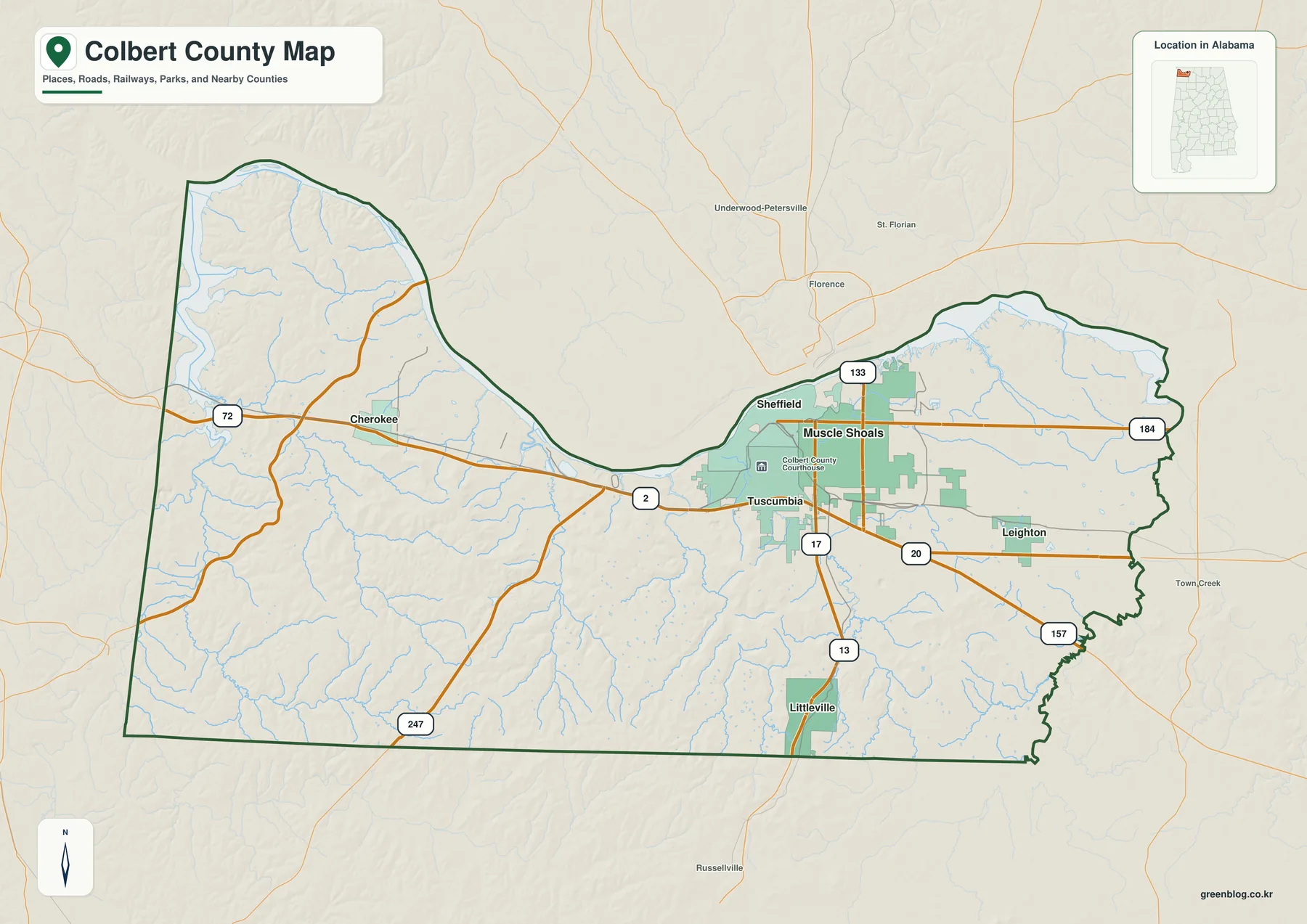
For general orientation, start with Tuscumbia near the center of the main road connections. From there, Muscle Shoals and Sheffield are easy to locate to the north and northeast near the river, while Cherokee is reached by following US 72 west. Littleville provides a useful southern reference. This approach is especially helpful for readers who need a printable overview for a class, a regional presentation, or a trip in which city-to-city relationships matter more than turn-by-turn directions.
The Shoals cluster stands apart from the rest of Colbert
The city map strips away much of the background detail and makes the settlement pattern easier to compare. Six major places are labeled: Muscle Shoals, Sheffield, Tuscumbia, Cherokee, Littleville, and Leighton. Muscle Shoals is shown as the largest of the six, and it sits only a short distance from both Sheffield and Tuscumbia. Together, those three names create a compact group in the northeast. Leighton remains relatively close to that group, but Cherokee and Littleville are clearly separated from it.
This spacing matters because a list of city names does not show how unevenly they are distributed. The Shoals communities occupy a small part of the county near the Tennessee River, while a much larger area lies between that cluster and the western and southern towns. The courthouse marker in Tuscumbia also gives the map a convenient administrative reference point. Readers can quickly see that the county seat is close to the main urban cluster rather than near the geographic center of the county.
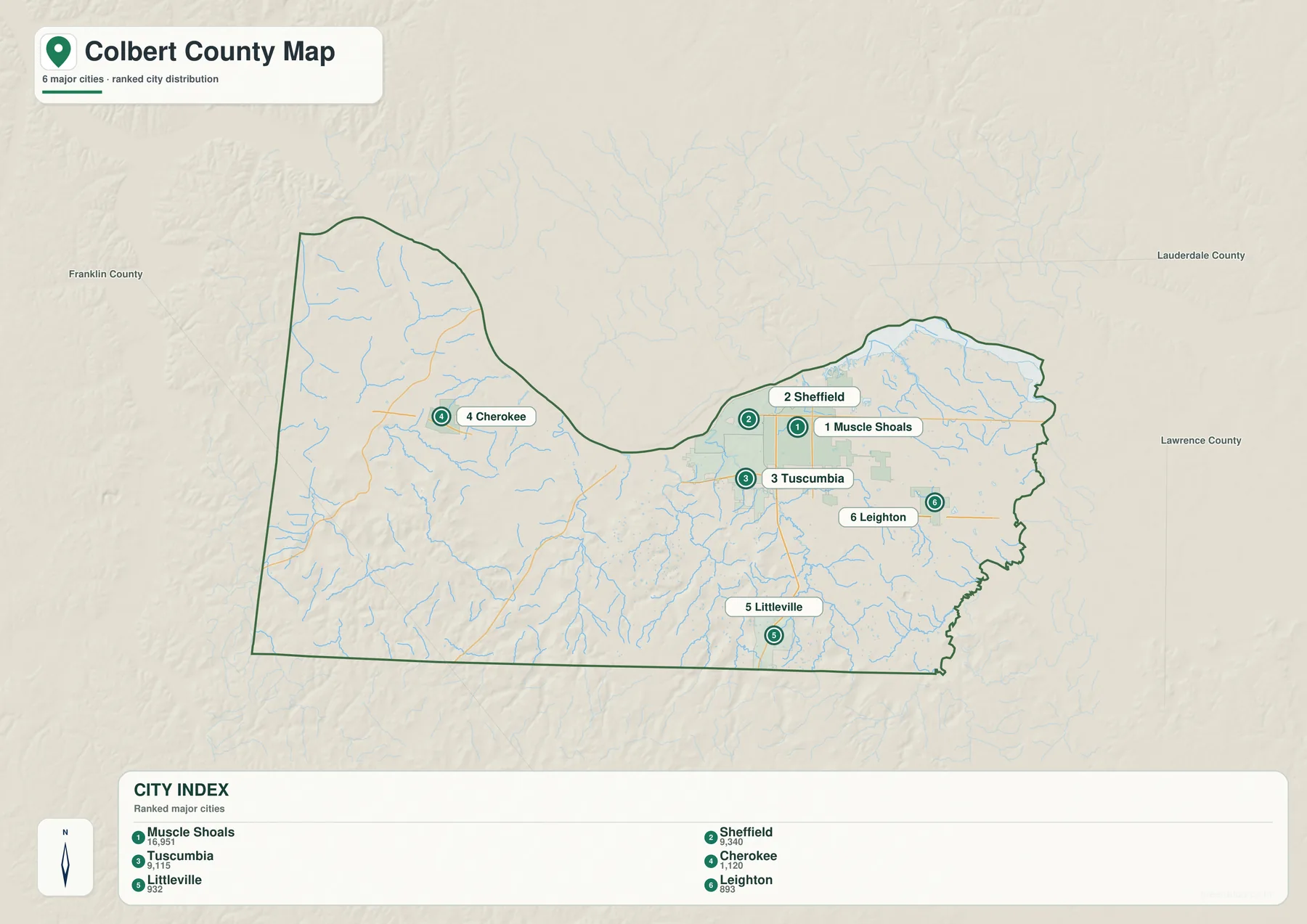
Nearby county labels add context without turning the map into a regional atlas. Lauderdale County lies across the river to the north and northeast, Lawrence County is to the east, and Franklin County borders the western side. Those names help place Colbert within northwest Alabama and show that the Shoals area is not isolated from surrounding communities. The city map is still best used for relative position rather than exact navigation, but it is one of the clearest ways to understand which places are neighbors and which are separated by long stretches of rural land.
The Tennessee River dominates a dense network of smaller waterways
On the water map, the Tennessee River is impossible to miss. It forms the broad northern water corridor and follows the same sweeping curve that gives the county boundary its distinctive shape. South of the river, however, the map fills with a much finer web of streams. Dry Creek, Spring Creek, Rock Creek, and Buzzard Roost Creek are among the named channels that help trace drainage through the interior. Their branching shapes become especially noticeable in the southern and western parts of the county, where the terrain is more dissected.
The map also marks smaller lakes and ponds, including Mississippi Pond, Burney Pond, Nichols Pond, Brush Pond, Horseslot Pond, Fawn Lake, Garrets Lake, and Hyde Lake. These features are small compared with the Tennessee River, but they make the water map more useful for local orientation because they provide recognizable points away from the river corridor. The page should not be read as a flood-zone map, wetland determination, or legal shoreline survey. Its purpose is to show where mapped water features sit in relation to the county boundary and terrain.
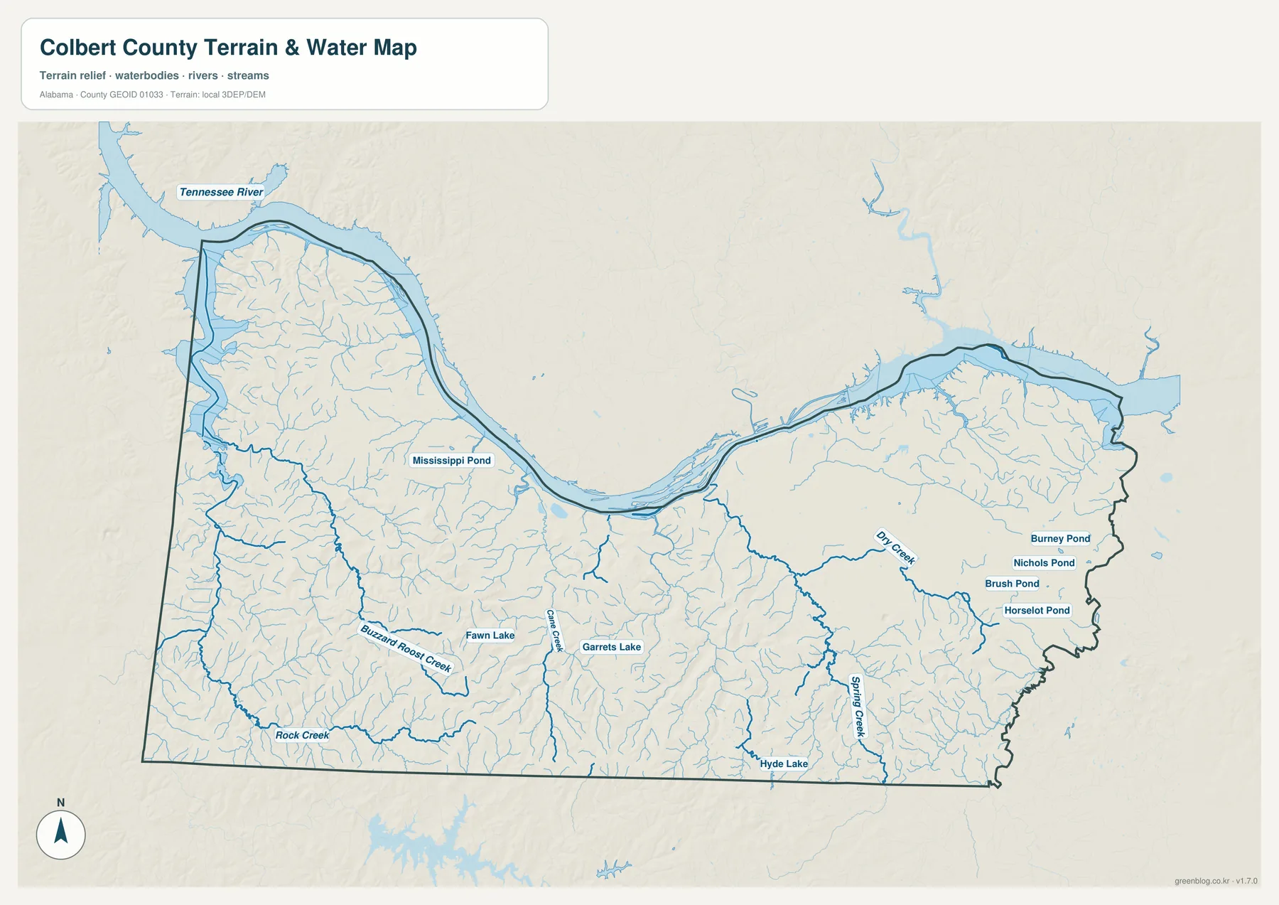
Pairing the water map with the city map adds another layer of useful context. Sheffield and Muscle Shoals sit very close to the Tennessee River, while Tuscumbia is slightly farther inland. Smaller streams become much more prominent south and west of the urban cluster. When planning an outdoor trip or comparing potential routes, these relationships can help with broad orientation, but current road conditions and official access information should always be checked separately.
Low river ground gives way to ridges and valleys
The elevation map explains why the interior stream network looks so different from the broad river corridor. The legend is scaled from roughly 125 to 260 meters, while the map notes an actual elevation range of about 80 to 296 meters and a mean of 183 meters. Darker green tones spread along much of the Tennessee River, indicating relatively low ground. Farther south, yellow, tan, and brown areas become more common as the land rises and breaks into a tighter pattern of ridges and valleys.
The strongest relief appears across parts of the south-central and southwestern interior, where narrow valleys cut between higher ridges. The northwest also shows a clear transition from lower land near the river to more rugged ground inland. Eastern Colbert looks smoother by comparison, though elevation still increases in places away from the river. This is a useful reminder that the county’s terrain cannot be described simply as flat river country or rolling upland; both settings occur within the same boundary.
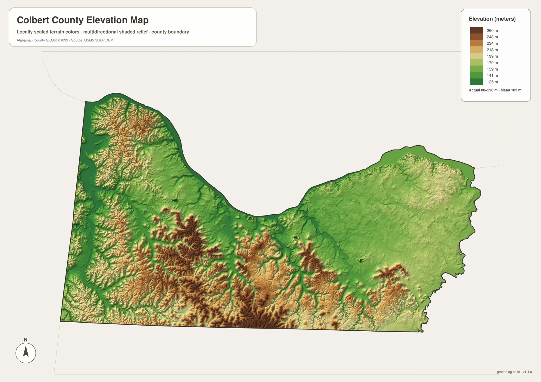
The elevation map works well beside the water map because many of the smaller creeks follow lower corridors between ridges. It is not a substitute for a survey, engineering plan, or site-specific elevation certificate. Instead, it gives readers a county-wide view of relative height: where the broad lowlands lie, which parts of the interior are more rugged, and how quickly the terrain changes as you move away from the Tennessee River.
Choosing the right map for a specific task
The four maps are most useful when chosen by purpose rather than viewed as interchangeable versions of the same image. Use the county map when roads, boundaries, and several kinds of features need to remain visible at once. The city map is faster when the question is simply where the main communities sit in relation to one another. The water map is the better choice for following the Tennessee River, named creeks, and smaller ponds, while the elevation map shows where low river ground changes into higher ridges and valleys.
Combining two views often answers a question more clearly than relying on one. A city-and-water comparison shows how closely the Shoals cluster hugs the river. A water-and-elevation comparison helps explain why small creeks branch through the more rugged southern interior. Roads and elevation together can also give a better sense of why some routes cross broad low ground while others pass through more broken terrain. For classroom work, travel planning, regional presentations, and personal reference, that kind of side-by-side reading keeps the maps practical without requiring specialized GIS software.
The WebP versions on this page are optimized for on-screen viewing. If you need larger files for printing, the download box below contains the county, city, water, and elevation maps as four high-resolution A3 JPG files inside one ZIP archive. That makes it easy to save all four at once and choose the appropriate map later without returning to the page for each individual file.
Frequently Asked Questions
Which communities form the main urban cluster in Colbert County?
Muscle Shoals, Sheffield, and Tuscumbia form the closest group of major communities on the maps, all near the Tennessee River in the northeastern part of the county. Leighton is farther east, while Cherokee and Littleville are separated from that cluster to the west and south.
What waterways are labeled besides the Tennessee River?
Named features include Dry Creek, Spring Creek, Rock Creek, and Buzzard Roost Creek, along with smaller ponds and lakes such as Mississippi Pond, Burney Pond, Nichols Pond, Fawn Lake, Garrets Lake, and Hyde Lake. The map is for general reference and does not identify flood zones or legal water boundaries.
Can the elevation map be used for construction or surveying?
No. It is designed to compare relative elevation and terrain across the county. Construction, engineering, property boundary work, and site-specific elevation decisions require current professional surveys or other official data prepared for those purposes.
Map File Information
Download Colbert County map files
- Included Files: County, city, water, and elevation maps
- File Type: Four high-resolution A3 JPG files bundled in one ZIP archive
- Intended Use: Printing, education, presentations, and map-based projects
Related Maps
- Along the Cahaba Valley: Bibb County Alabama Map
- Between Two River Systems: A Clarke County Alabama Map
- Calhoun County Alabama Map
Sources and references
- Colbert County official history
- Alabama Department of Transportation maps
- Tennessee Valley Authority: Wilson Dam
- USGS National Hydrography
- USGS 3D Elevation Program
Green Map creates custom-edited map images using open geographic data sources such as geoBoundaries, Natural Earth, OpenStreetMap, and government open data. These maps are edited visual materials, not raw data files, and are provided for education, documents, presentations, and graphic reference.