Wabaunsee County sits in northeastern Kansas, where small communities are separated by deeply cut Flint Hills terrain rather than one continuous urban corridor. Alma is the county seat, while Maple Hill, Alta Vista, Eskridge, McFarland, and Paxico serve as smaller reference points. K-99 runs through Alma, K-4 links the southern towns, and US 40 and K-18 cross the northern part of the county near the Kansas River. High-resolution map files are available for download in the section below.
This guide follows those communities across the road, water, and elevation views, with terrain ranging from about 273 to 488 meters. Mill Creek and its branches divide much of the interior, Lake Wabaunsee occupies the southern hills, and the Kansas River forms a broad northern lowland. WebP previews are available for quick viewing, and the matching high-resolution JPG files can be downloaded together in one ZIP for printing, classroom work, or offline reference.
Table of Contents
Alma provides the clearest road and county-seat reference
Alma sits near the middle of Wabaunsee County where K-99 runs north–south through the community. From Alma, the route reaches K-18 and US 40 to the north and continues toward K-4 and Eskridge to the south. Eastward roads connect the county seat with Newbury and Maple Hill, while the western side opens into more sparsely settled Flint Hills country.
The Kansas Historical Society records Alma as the county seat. Wabaunsee town served that role first, but elections in 1866 moved the seat to Alma, and another contest in 1871 confirmed the decision. The modern map still shows why Alma works well as a county reference: roads, rail lines, and county functions meet near the center of the interior.
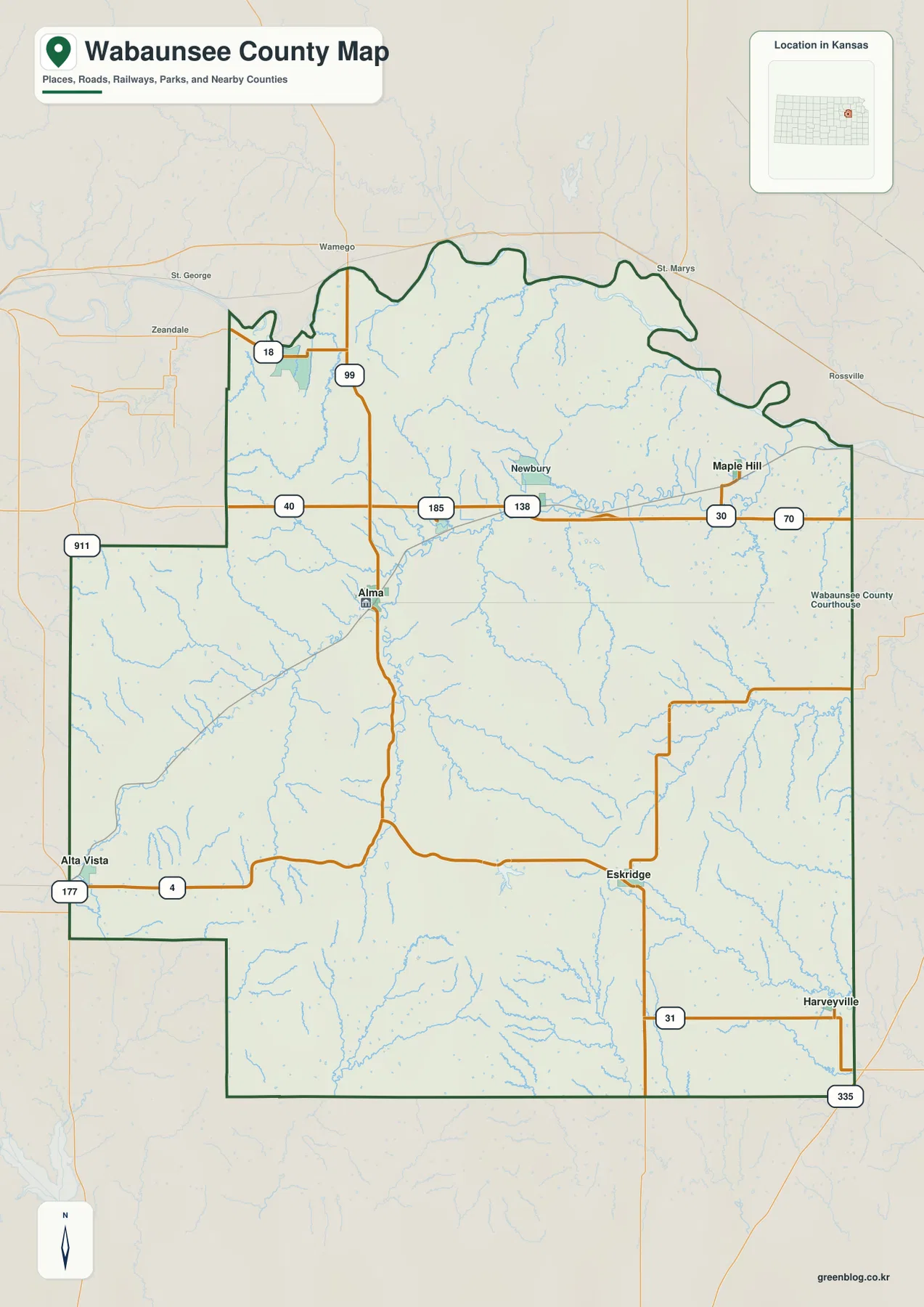
Alta Vista occupies the southwestern side near K-4, while Eskridge sits farther southeast along the same southern corridor. Maple Hill lies in the northeast below US 40. McFarland and Paxico provide smaller northern references, and the irregular northern county boundary follows bends and low ground near the Kansas River.
The city index is spread among several small communities
The ranked city panel lists Alma at 1,063, Maple Hill at 772, Alta Vista at 443, Eskridge at 419, McFarland at 363, and Paxico at 166. These are map index values rather than current official population estimates, and they show a very different settlement pattern from counties dominated by one large city.
Alma and Maple Hill provide the strongest central and northeastern references. Alta Vista and Eskridge divide the southern K-4 corridor, while McFarland and Paxico help locate the US 40 and I-70 side of the county. Their spacing reflects the local terrain: communities often sit near road junctions or broader creek valleys rather than forming one continuous strip.
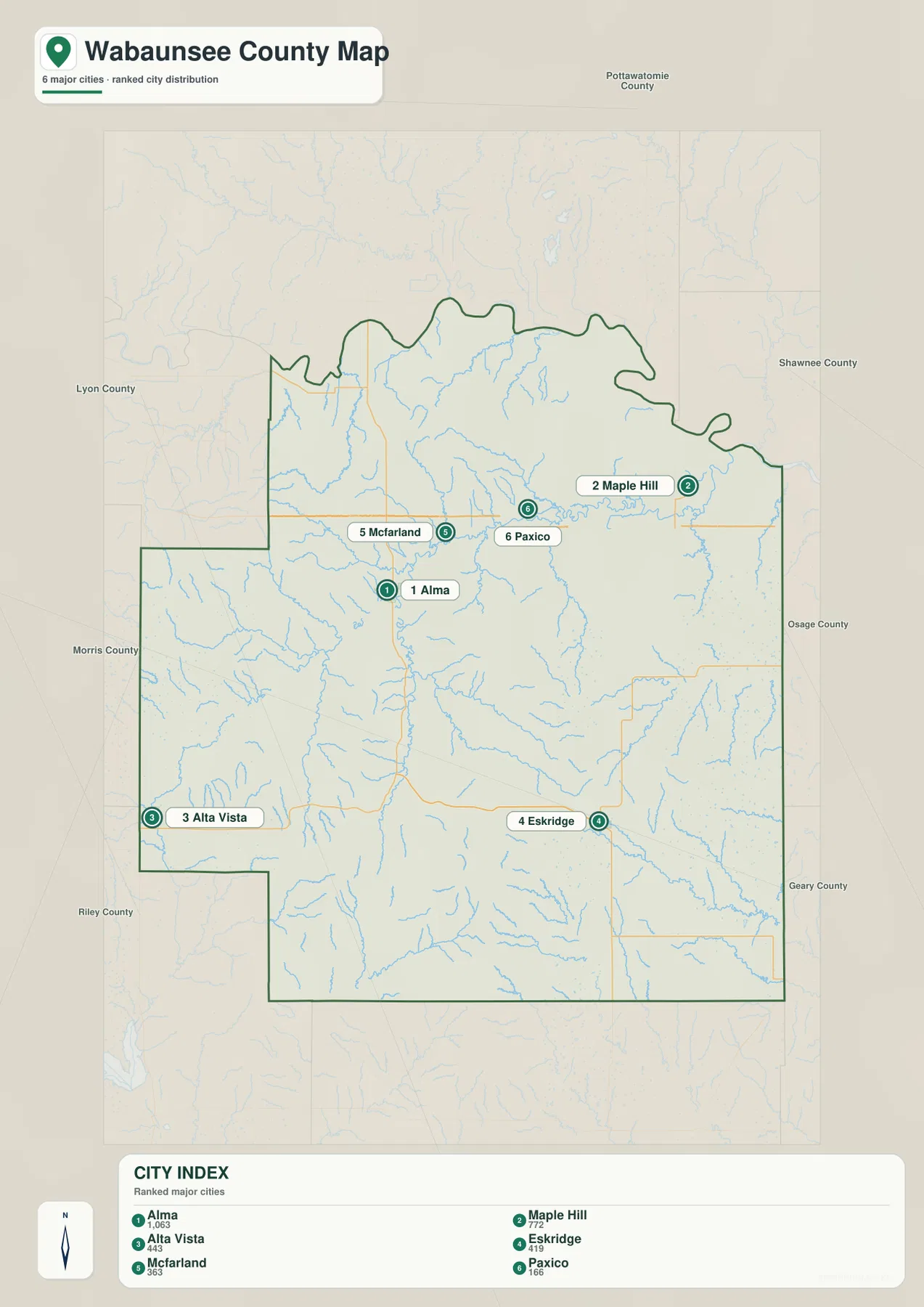
Because the communities are small, road and drainage context matters as much as the ranking itself. A town marker that looks close on a county-wide map can still be separated from the next community by several ridges, narrow valleys, and winding rural roads.
Mill Creek and its branches cut the heart of the Flint Hills
Mill Creek is the strongest interior drainage feature. West Branch Mill Creek approaches the central county from the southwest, South Branch Mill Creek comes up from the south, and East Branch Mill Creek joins the network from the southeast. The main channel then bends eastward while collecting many short tributaries from the surrounding hills.
The Kansas River forms the broad northern water reference, with Antelope Creek descending toward it from the northwestern interior. Spring Creek cuts through the southwestern hills, while South Branch Wakarusa River creates a separate long valley in the southeastern part of the county.
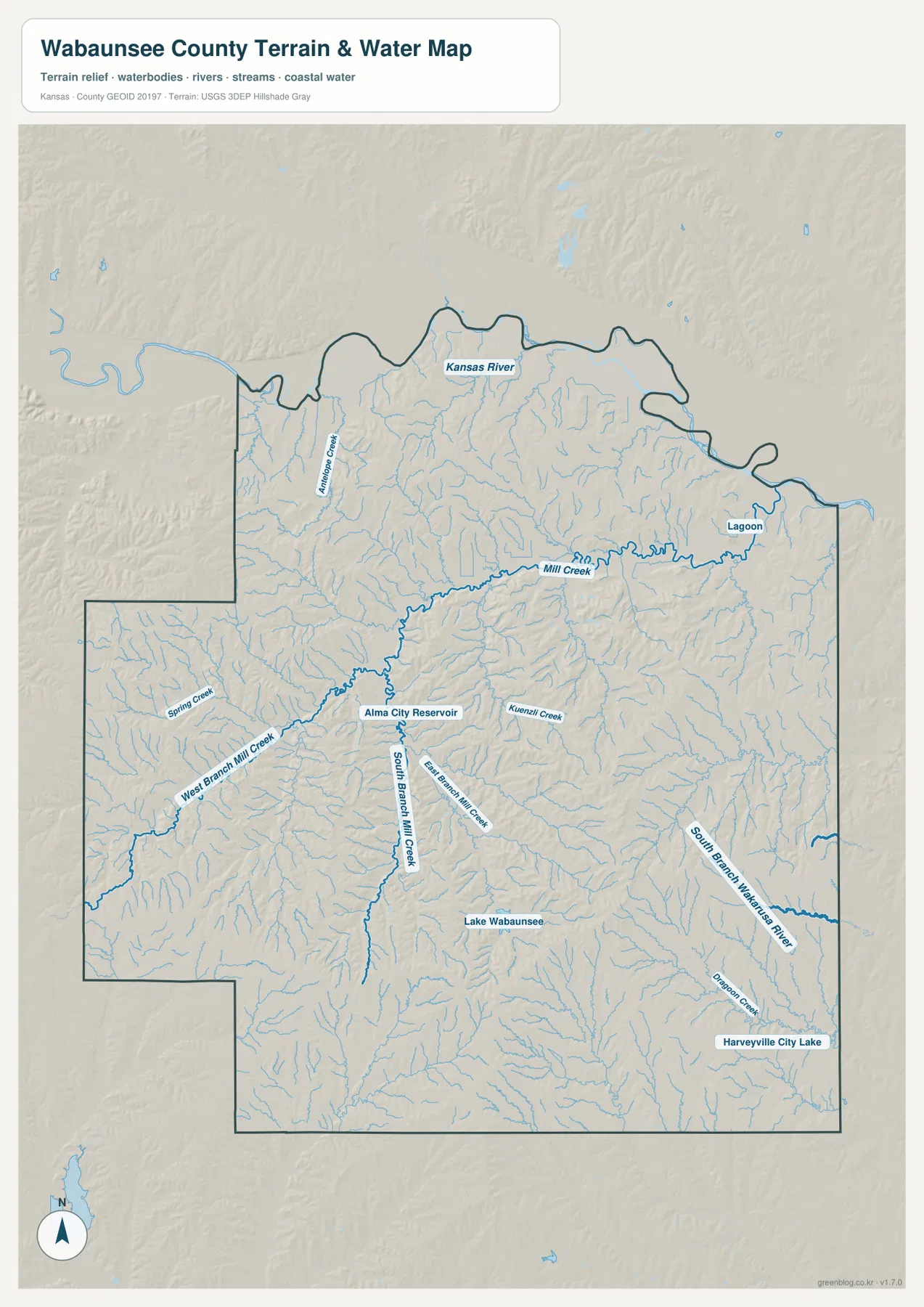
Alma City Reservoir provides a small water reference just south of Alma, while Lake Wabaunsee occupies the southern Flint Hills. Harveyville City Lake appears farther southeast. Kuenzli Creek, Dragoon Creek, and many unnamed tributaries reinforce how thoroughly the county is divided by narrow drainage lines.
This water image is intended for geographic reference rather than floodplain, navigation, water-quality, parcel, or legal-access decisions. Lake levels and creek conditions can change, so current agency information should be used whenever access or safety matters.
Relief from 273 to 488 meters separates the Kansas River lowland from the southern hills
The elevation surface ranges from about 273 to 488 meters, with a mean near 381 meters. The Kansas River side and much of the northeast appear as broad green low ground, while higher tan and brown hills dominate the south and southwest. More than 200 meters of county-wide relief gives Wabaunsee County a strongly rolling appearance.
Mill Creek and its tributaries carve green corridors into the uplands. Around Alma, low creek bottoms sit close to short, steep ridges. Farther south toward Eskridge and Lake Wabaunsee, the ridges become more continuous and the branching valleys are especially dense.
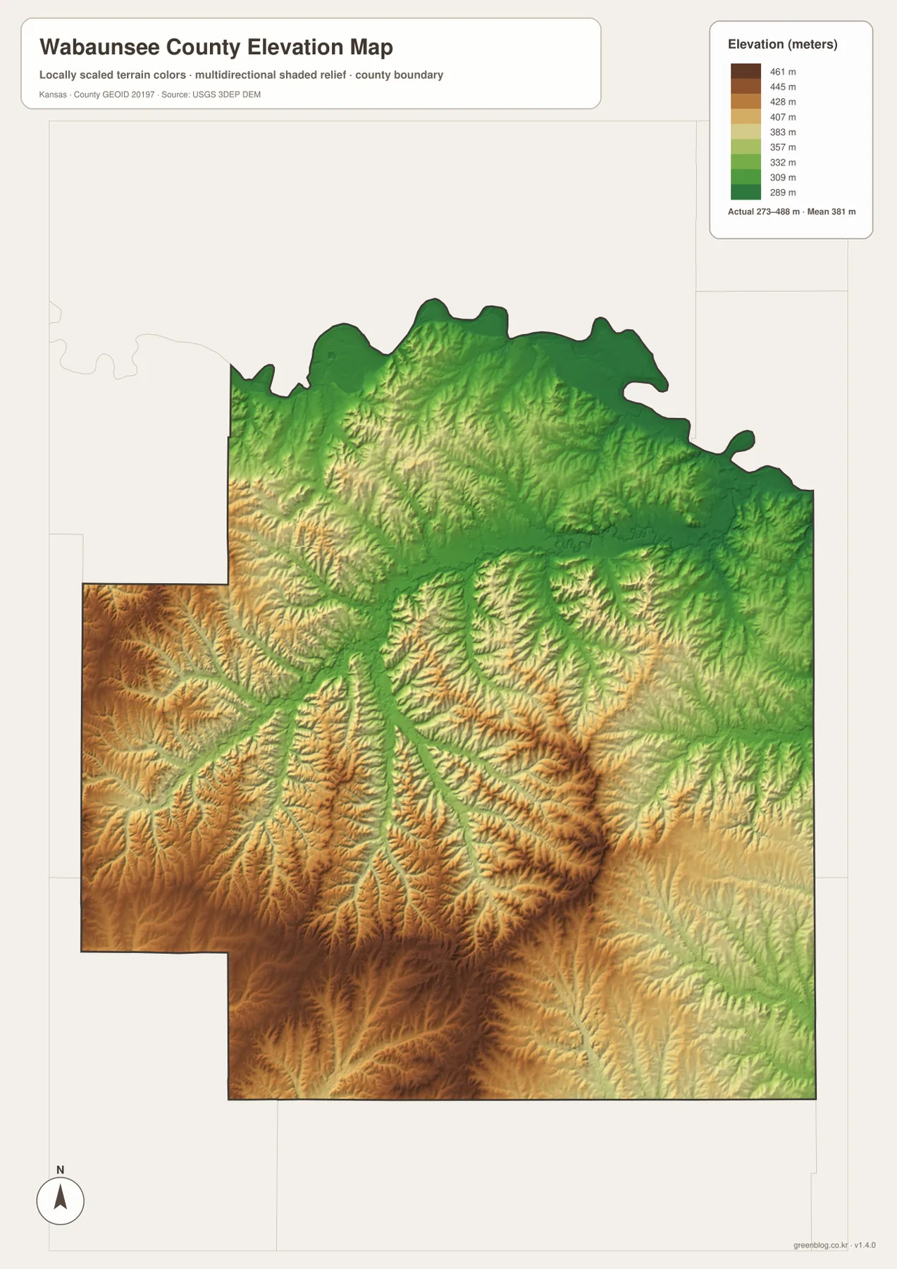
The Kansas Historical Society places Wabaunsee County across the Flint Hills Uplands, Glaciated Region, and Osage Cuestas. The supplied relief map makes the Flint Hills influence especially obvious in the southern and western sections, while the northern river country is lower and broader.
The elevation surface is generalized for county-scale comparison. It is not survey-grade or engineering-grade measurement and should not be used for parcel elevations, construction grades, drainage design, or legal boundary work.
Alma’s native-stone buildings link local geology with the county seat
Travel Kansas promotes Alma as the “City of Native Stone.” Its downtown historic district includes a concentration of architecturally significant buildings dating from 1880 to 1936, many using locally quarried Cottonwood Limestone. The stone architecture gives the small county seat a strong visual connection to the limestone-rich Flint Hills around it.
Kansas Historical Society preservation records also emphasize the role of nearby stone quarries in Alma’s late nineteenth- and early twentieth-century commercial buildings. For map readers, this makes Alma more than a road junction: the surrounding terrain supplied material that became part of the town’s built character.
The Native Stone Scenic Byway connects Eskridge, Alma, and Lake Wabaunsee
Kansas Tourism describes the Native Stone Scenic Byway as a 75-mile route through the Flint Hills. Within Wabaunsee County, it follows K-4 through the Eskridge area, turns onto K-99 toward Alma, and continues north toward K-18. Lake Wabaunsee is listed as one of the route’s official points of interest.
That route provides a useful way to tie the maps together. K-4 crosses the higher southern hills, K-99 follows the Alma corridor, and K-18 reaches the northern part of the county. The surrounding ridges, creek valleys, stone fences, and limestone communities explain why the drive is associated with the Native Stone landscape.
Lake Wabaunsee combines southern Flint Hills scenery with twentieth-century history
The Kansas Historical Society county timeline records that Lake Wabaunsee was completed in 1937 and began filling that year. During World War II, a German prisoner-of-war camp operated at the lake from 1944 to 1945.
Today the lake remains one of the clearest geographic landmarks in the southern county. On the water map it sits among tightly spaced hills and tributaries, while Kansas Tourism identifies the lake and nearby Eskridge area as outdoor stops along the Native Stone Scenic Byway.
For posters, classroom prints, or presentation slides, use the original JPG files in the download archive rather than enlarging the web previews. Small highway shields, creek names, town labels, and the elevation legend remain clearer at the higher resolution.
Frequently Asked Questions
Which community is largest on the supplied city index?
Alma ranks first at 1,063. Maple Hill is 772, Alta Vista 443, Eskridge 419, McFarland 363, and Paxico 166. These are map index values rather than current official population estimates.
Where is Lake Wabaunsee in the county?
Lake Wabaunsee is in the southern-central Flint Hills portion of the county, near the Eskridge side of the K-4 corridor. It is also identified by Kansas Tourism as a point of interest on the Native Stone Scenic Byway.
Can the 273–488 meter elevation image be used for surveying?
No. It is a generalized county-scale terrain image for comparing the Kansas River lowland with higher Flint Hills ridges and creek valleys. Parcel elevations, engineering grades, drainage design, and legal boundary work require more precise official data and, where needed, professional surveying.
Map File Information
The archive contains the Wabaunsee County, Kansas general county map, city map, terrain-and-water map, and elevation map as original high-resolution JPG files.
- Included Files: Use only the versions confirmed in the article and supplied images
- File Type: Use the confirmed download contents
- Intended Use: Printing, education, presentations, and map-based projects
Related Maps
Sources and references
- Kansas Historical Society: Wabaunsee County, Kansas — county-seat history, physiographic regions, and Lake Wabaunsee timeline
- Travel Kansas: Alma — native-stone architecture and downtown historic-district information
- Kansas Tourism: Native Stone Scenic Byway — the K-4, K-99, and K-18 route and Lake Wabaunsee point of interest
- U.S. Census Bureau TIGER/Line Shapefiles — county boundary and geographic reference data
- USGS National Hydrography — river and stream reference data
- USGS 3D Elevation Program — elevation and terrain reference data
Green Map creates custom-edited map images using open geographic data sources such as geoBoundaries, Natural Earth, OpenStreetMap, and government open data. These maps are edited visual materials, not raw data files, and are provided for education, documents, presentations, and graphic reference.