Wallace County occupies the far western edge of Kansas, where Sharon Springs serves as the county seat and US 40 crosses an open High Plains landscape. Wallace lies farther east, while Weskan and Sunland provide western references near the Colorado side. K-27 runs north–south through Sharon Springs, and the terrain rises steadily toward the state line before dropping into the Smoky Hill River and creek-cut valleys to the east. High-resolution map files are available for download in the section below.
This guide follows Sharon Springs, Wallace, and the surrounding High Plains across the road, water, and elevation views, with terrain ranging from about 958 to 1,231 meters. WebP previews are available for quick viewing, and the matching high-resolution JPG files can be downloaded together in one ZIP for printing, classroom work, or offline reference.
Table of Contents
Sharon Springs anchors the US 40 and K-27 road network
Sharon Springs sits near the middle of Wallace County on US 40, with K-27 crossing the town north–south. The highway provides the main east–west reference between Weskan and Sunland on the western side and Wallace farther east. Away from this corridor, local roads spread across broad agricultural and grazing land where creek valleys often become the most useful natural landmarks.
The Kansas Historical Society identifies Sharon Springs as the county seat. During the county’s second organization in 1889, Sharon Springs served as the temporary seat and remained the administrative center. Travel Kansas also highlights the town as a junction for the Land & Sky Scenic Byway and the western Kansas routes that follow US 40.
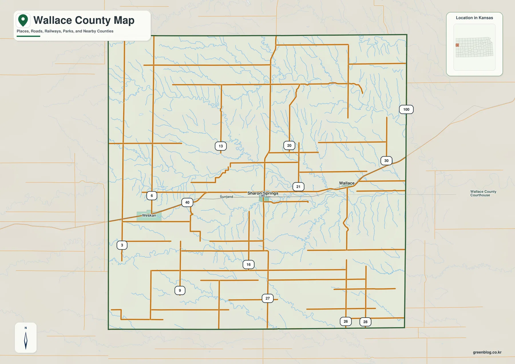
Wallace lies east of Sharon Springs near US 40 and close to the historic Fort Wallace area. Weskan is near the Colorado side and provides one of the best road references for Mount Sunflower. The road pattern stays simple across the open uplands, but the water and elevation maps reveal much more rugged relief along the river and creek valleys.
Only Sharon Springs and Wallace appear on the ranked city panel
The supplied city panel lists Sharon Springs at 817 and Wallace at 48. These are map index values rather than current official population estimates, but they make the county’s settlement pattern clear: one small administrative center and an even smaller eastern community within a very rural county.
Both towns are tied to the US 40 corridor, but their surroundings differ. Sharon Springs sits at the K-27 junction, while Wallace is closer to the Smoky Hill River drainage and the Fort Wallace historic area. Weskan appears on the general map but is not part of the ranked city panel.
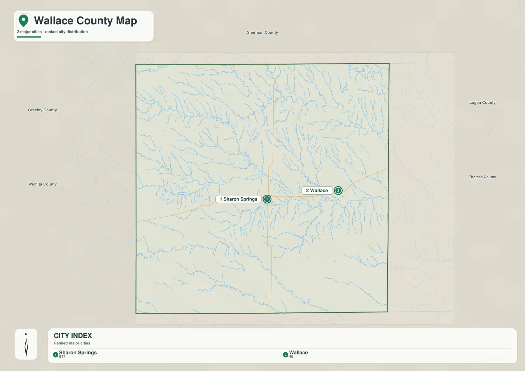
Because Wallace County has few incorporated population centers, roads, watercourses, and elevation changes matter as much as city markers. The broad western uplands and the deeply cut eastern drainage network provide most of the geographic contrast.
The Smoky Hill River and Lake Creek system cut deep valleys into the High Plains
The Smoky Hill River is the strongest central water feature. It enters from the west, bends through the south-central county, and continues east while collecting tributaries such as Willow Creek, Eagle Tail Creek, Pond Creek, and Rose Creek.
Across the north, Middle Fork Lake Creek, South Fork Lake Creek, North Fork Lake Creek, Lake Creek, and Goose Creek form another dense drainage network. Old Maid Pool appears as a small named water body in the north-central interior, surrounded by short tributaries that descend from the higher plains.
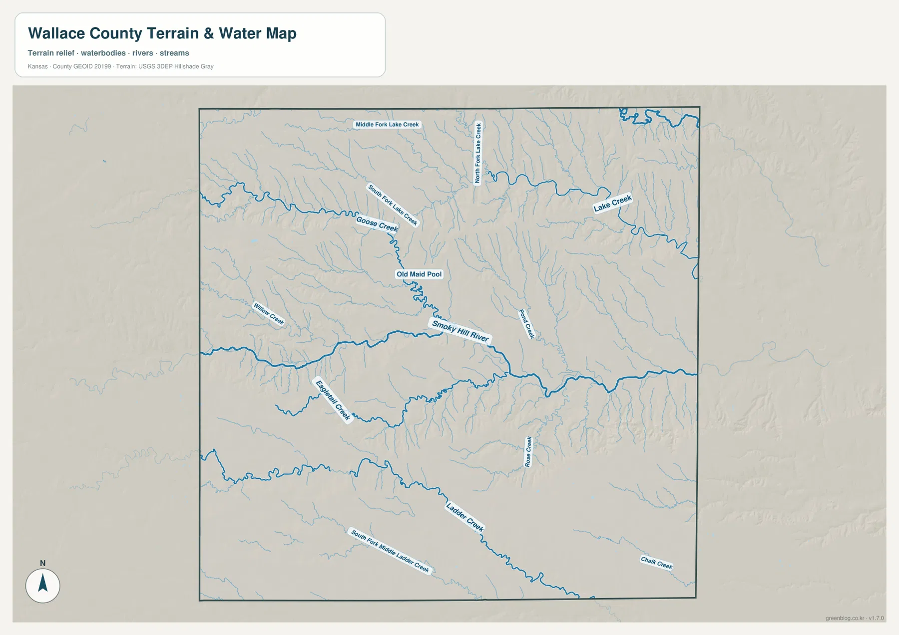
Ladder Creek crosses the southern part of the county, with South Fork Middle Ladder Creek adding another long drainage line. Chalk Creek appears in the southeast, while many unnamed channels create narrow cuts across otherwise broad uplands.
Kansas Historical Society material notes that the South Fork of the Smoky Hill River can be dry at times and may carry water after hard rains. The supplied map is therefore a geographic reference rather than a real-time flood, water-depth, navigation, or access map.
Elevation from 958 to 1,231 meters rises toward Colorado and falls into eastern valleys
The elevation surface ranges from about 958 to 1,231 meters, with a mean near 1,103 meters. Brown and tan high ground dominates the west and northwest, while greener low terrain expands toward the east and along the major drainage corridors.
Wallace County contains Mount Sunflower, the highest natural point in Kansas. The Kansas Historical Society describes it as slightly above 4,000 feet, and the map’s maximum elevation of about 1,231 meters closely matches that setting near the Colorado line.
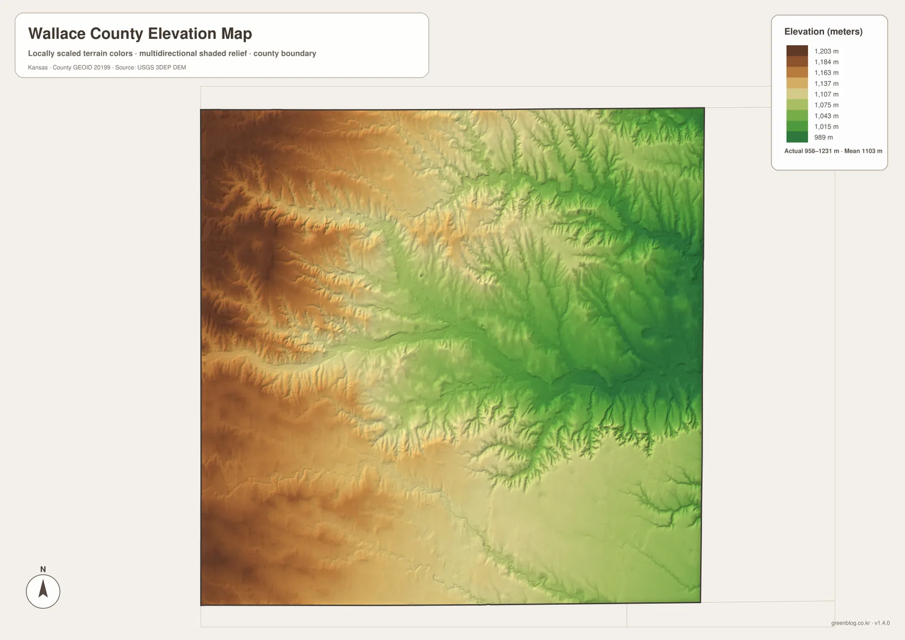
The surface does not simply slope evenly from west to east. The Smoky Hill River and Lake Creek networks cut narrow low corridors into the uplands, leaving short ridges between neighboring tributaries. Even within the high western half, erosion creates noticeable local relief.
The elevation surface is generalized for county-scale comparison. It is not survey-grade or engineering-grade measurement and should not be used for parcel elevations, construction grades, drainage design, or legal boundary work.
Mount Sunflower is Kansas’s highest point, but it looks like open High Plains rather than a mountain peak
Mount Sunflower sits near the Colorado border in western Wallace County. Despite its name, the Kansas Historical Society describes the point as part of a gradual rise in the High Plains rather than a sharp isolated summit.
That description matches the elevation image: the entire western side is high, and the maximum point blends into a broad elevated surface. Travel Kansas identifies Weskan as the closest community and highlights Mount Sunflower as a landmark along the Land & Sky region.
Fort Wallace ties the eastern county to the Smoky Hill Trail
Fort Wallace began in 1865 as Camp Pond Creek and later became a major military post along the Smoky Hill Trail. The Fort Wallace Museum explains that the post helped protect stage traffic, settlers, and later railroad construction moving across western Kansas.
Most of the original fort buildings are gone, but the museum and historic cemetery near the community of Wallace preserve the site’s history. On the maps, the US 40 corridor and Smoky Hill River valley help explain why this part of the county became an important transportation and military location.
Traveling west from Sharon Springs brings a steady climb toward the state’s highest ground
Following US 40 from Sharon Springs toward Weskan looks relatively simple on the road map, but the elevation surface shows a steady climb toward the Colorado boundary. Much of the western side exceeds 1,100 meters, and the Mount Sunflower area approaches the county maximum.
Heading east toward Wallace shows the opposite transition. The Smoky Hill River and tributary valleys become more prominent, overall elevation falls, and the terrain is increasingly dissected by drainage lines. Comparing the road and relief views side by side makes this west-to-east contrast especially clear.
For posters, classroom prints, or presentation slides, use the original JPG files in the download archive rather than enlarging the web previews. Small road labels, creek names, community text, and the elevation legend remain clearer at the higher resolution.
Frequently Asked Questions
Which community is largest on the supplied city index?
Sharon Springs ranks first at 817, while Wallace is 48. These are map index values rather than current official population estimates. Weskan appears on the general county map but is not included in the ranked city panel.
Where is Mount Sunflower?
Mount Sunflower is near the Colorado border in western Wallace County and is the highest natural point in Kansas. Weskan is one of the nearest communities, and the elevation map shows that the landmark sits on a broad high plain rather than a steep isolated mountain.
Can the 958–1,231 meter elevation image be used for surveying?
No. It is a generalized county-scale terrain image for comparing the high western plains with lower Smoky Hill River and creek valleys. Parcel elevations, engineering grades, drainage design, and legal boundary work require more precise official data and, where needed, professional surveying.
Map File Information
The archive contains the Wallace County, Kansas general county map, city map, terrain-and-water map, and elevation map as original high-resolution JPG files.
- Included Files: Use only the versions confirmed in the article and supplied images
- File Type: Use the confirmed download contents
- Intended Use: Printing, education, presentations, and map-based projects
Related Maps
Sources and references
- Kansas Historical Society: Wallace County, Kansas — county seat, Mount Sunflower, High Plains setting, and county history
- Travel Kansas: Sharon Springs — Sharon Springs and regional scenic-byway information
- Fort Wallace Museum: History — Fort Wallace, Smoky Hill Trail, and Butterfield Overland Despatch history
- U.S. Census Bureau TIGER/Line Shapefiles — county boundary and geographic reference data
- USGS National Hydrography — river and stream reference data
- USGS 3D Elevation Program — elevation and terrain reference data
Green Map creates custom-edited map images using open geographic data sources such as geoBoundaries, Natural Earth, OpenStreetMap, and government open data. These maps are edited visual materials, not raw data files, and are provided for education, documents, presentations, and graphic reference.