The Geneva County Map places a long stretch of southeastern Alabama between the Florida line and the small towns of the Wiregrass region. Geneva sits near the middle of the southern half, where the Pea River enters the Choctawhatchee River. Samson marks the west, Hartford lies to the northeast, and Slocomb and Malvern spread across the eastern side. The four supplied maps let you compare the county boundary and roads, the distribution of six principal towns, the dense network of rivers and creeks, and a terrain range of roughly 20 to 103 meters. A ZIP containing four original high-resolution A3 JPG maps is available for download when you need clearer labels or print-ready files.
This is not a county that can be understood from one large urban center. Travel depends on state routes, rural roads, river crossings, and the different directions that local communities face. Western Geneva County relates to Samson and Covington County, the eastern towns are closer to Houston County and the Dothan area, and roads along the southern edge continue into the Florida Panhandle. Looking at the maps separately avoids crowding too much information into one sheet: the county map is the best general reference, the city graphic simplifies settlement, the water map brings small tributaries forward, and the elevation surface explains the low valleys and higher rolling ground.
Table of Contents
A long Alabama county directly north of the Florida line
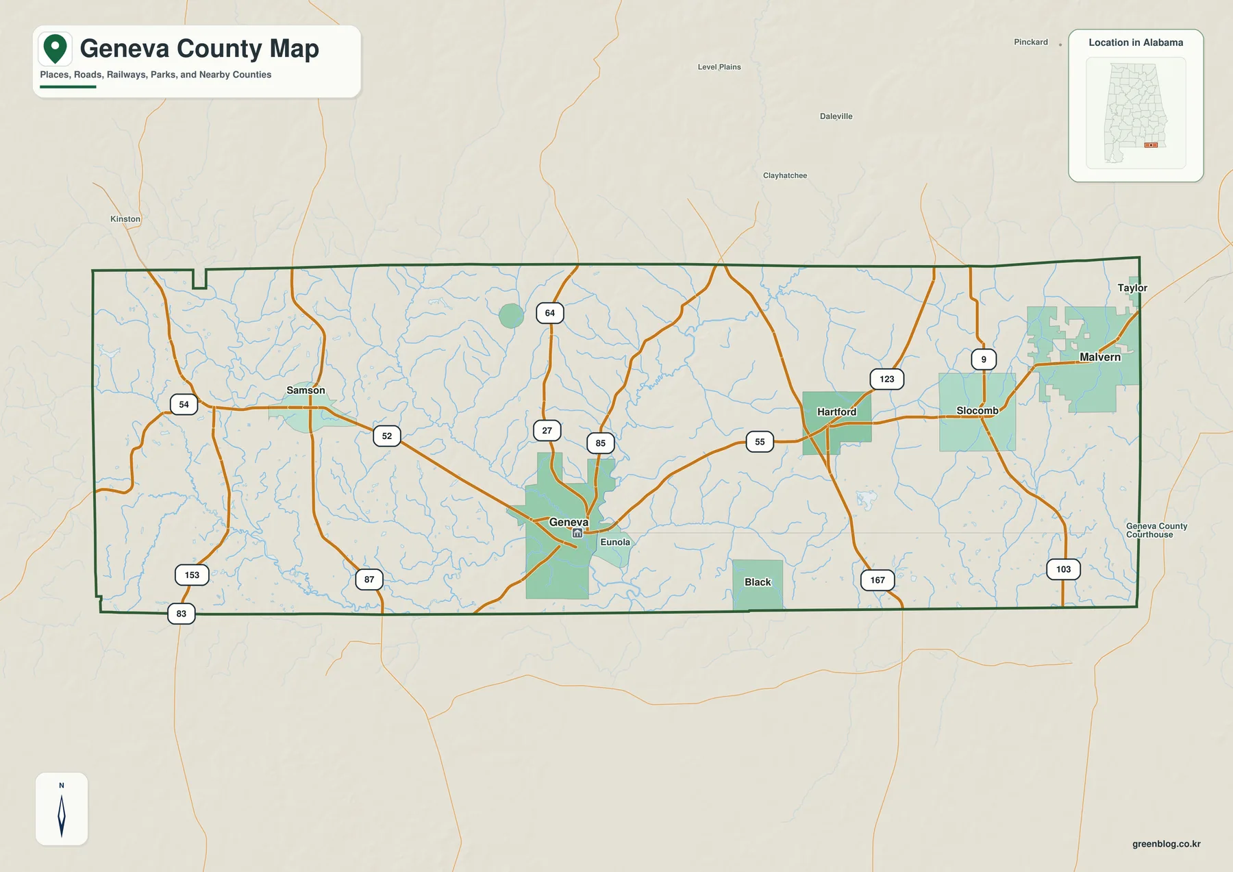
Geneva County has an elongated east-west shape. Coffee County lies to the north, Dale County is visible beyond the northeastern side, Houston County borders the east, and Covington County lies west of the county line. Its southern edge meets the Florida Panhandle for most of the county’s width. That position gives the map two different regional contexts: the county is part of Alabama’s Wiregrass area, but southern roads also lead directly toward communities across the state boundary rather than ending at an isolated outer edge.
The county seat is near the south-central part of the map. Route 52 provides the clearest west-to-east framework, linking Samson with Geneva and continuing toward Hartford. Routes 27 and 85 help organize the area north and northeast of Geneva, while 87, 83, and 153 appear on the western and southwestern side. Farther east, route numbers 55, 123, 9, 103, and 167 help separate Hartford, Slocomb, Malvern, and the roads approaching Houston County. Because no Interstate cuts through Geneva County, these state and local routes carry the practical burden of travel between towns.
The place labels reveal a dispersed settlement pattern. Samson is the main western reference, Geneva occupies the administrative center near the two rivers, and Hartford lies northeast of it. Slocomb and Malvern are farther east, while Black is south of the main east-west town line. Smaller labels such as Coffee Springs, Eunola, and Taylor fill the rural spaces between the incorporated communities. They are useful orientation points when the map is used for local study, even though they do not all have the same legal status or population scale.
| State | Alabama |
|---|---|
| County | Geneva County |
| County seat | Geneva |
| 2025 population estimate | 27,554 |
| 2020 census population | 26,659 |
| Land area | About 574.5 square miles |
| Six towns emphasized on the city map | Geneva, Hartford, Slocomb, Malvern, Samson, Black |
| Major rivers | Pea River and Choctawhatchee River |
The source material in the package reports 27,554 residents for the July 2025 estimate and 26,659 people in the 2020 census. Spread across roughly 574.5 square miles of land, that population produces a map dominated by rural space rather than continuous development. Town names may appear close together on a small preview, but the road network and numerous stream crossings matter greatly when considering actual travel. The downloadable A3 image is especially useful for reading route numbers and smaller labels that are difficult to distinguish in a compressed browser preview.
Use this sheet as a county-scale orientation map, not as a legal or engineering document. It can establish the county boundary, neighboring areas, major road directions, and familiar place names for a report or travel overview. It does not show parcel ownership, exact right-of-way widths, active construction restrictions, or every rural road. Those tasks require current official transportation, cadastral, or local government records.
Six towns spread from Samson to Malvern
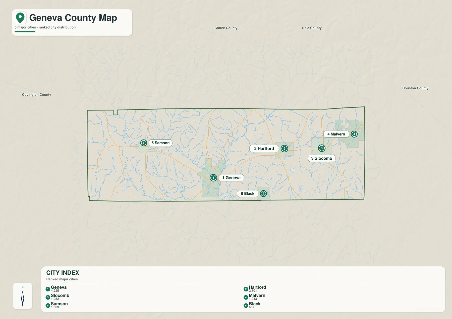
The city map removes most of the visual detail and focuses on six places. Its index lists Geneva at 4,225, Hartford at 2,701, Slocomb at 1,952, Malvern at 1,913, Samson at 1,669, and Black at 467. These are the reference figures printed on the supplied graphic, not a live population feed. They are best used to understand the ranking and relative scale shown by this particular map. Anyone needing the latest certified figure should check Census or local records rather than treating the index as a current official count.
Geneva is numbered first and stands apart as the county seat. It is positioned in the south-central county rather than at the geographic center, close to the river junction. Hartford, the second-ranked place, lies northeast of Geneva. Slocomb and Malvern occupy the eastern side, but they are not located at the same latitude: Slocomb is farther south and west, while Malvern is closer to the eastern edge. Their separation is easier to see on this simplified map than on the general road sheet.
Samson is the principal western town and sits by itself across a broad rural area from the eastern cluster. Black is shown south of the main towns and close to the Florida-facing side of the county. This distribution explains why Geneva County does not function as a compact ring of suburbs around one center. Different communities use different road directions and outside service areas. The western side looks toward Samson and Covington County, while the eastern side is more closely connected with Houston County and the Dothan region.
The numbered markers indicate rank, not a travel sequence, road mileage, or commuting time. Straight spacing on a small map can also hide the effect of creeks, bridge locations, and winding rural roads. For a classroom slide or a simple county profile, this city sheet is often enough because the place labels remain uncluttered. For navigation or route comparison, pair it with the county map so that each town can be matched to the appropriate state road.
A practical way to remember the arrangement is to place Geneva near the rivers, Samson in the west, Hartford to the northeast, Slocomb and Malvern in the east, and Black toward the southern boundary. Coffee Springs, Eunola, and Taylor can then be added from the general map to fill the spaces between those six larger labels. The two maps therefore answer different questions: one identifies the principal towns quickly, while the other explains how roads and smaller communities connect them.
Where the Pea River enters the Choctawhatchee
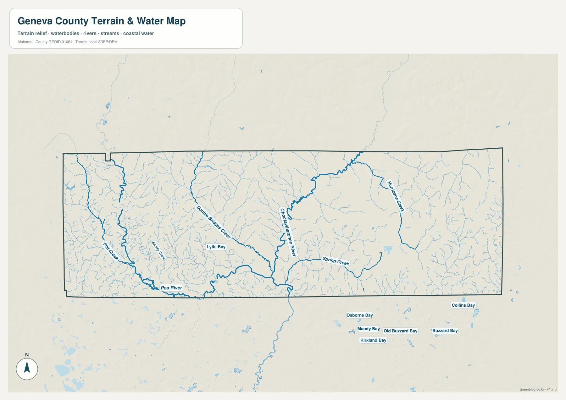
The most recognizable water feature is the confluence beside Geneva. The Pea River crosses the southern part of the county from the west and reaches the Choctawhatchee River near the city. The Choctawhatchee approaches from the north and continues south across the Florida line. That junction is more than a convenient map landmark. It helps explain why the county seat developed where it did and why the lower ground around Geneva differs from the rolling uplands farther east.
The detailed water sheet also shows how much of the county is drained by smaller channels. Double Bridges Creek runs through the central area, Spring Creek appears east of the Choctawhatchee, and Hurricane Creek is labeled in the northeastern drainage. Flat Creek and numerous unnamed branches spread across the west, while Lytle Bay appears near the central-western side. Many thin blue lines feed toward the Pea or Choctawhatchee, creating a much denser network than the simplified county map can display.
Geneva’s official history connects the river junction with early trade and transportation. The settlement began near the confluence, where water routes supported local movement before modern highways. A destructive flood in 1861 led residents to rebuild on higher ground, and the present city still reflects that relationship between the rivers and the raised urban core. Robert Fowler Memorial Park provides public access near the meeting of the two rivers, making the confluence a real local landmark rather than an abstract line on a map.
Comparing this image with the road map helps explain why some routes curve or depend on particular crossings. Rural roads must pass over a large number of tributaries before reaching Geneva, Samson, Hartford, or the Florida boundary. The water map can support general geographic study, outdoor planning, and an explanation of the county’s drainage, but it is not a flood-hazard product. It does not establish current water depth, navigable channels, safe boat access, property boundaries, or fishing permissions.
For a simple study exercise, locate the two main rivers first and mark their meeting point. Then trace Double Bridges Creek, Spring Creek, and the smaller branches back toward the uplands. When the high-resolution JPG is opened, the fine tributaries are easier to follow than they are in the WebP preview. A current park, boating, or emergency source should always be consulted before using the map for an actual trip near the water.
Low river valleys and higher rolling ground to the east
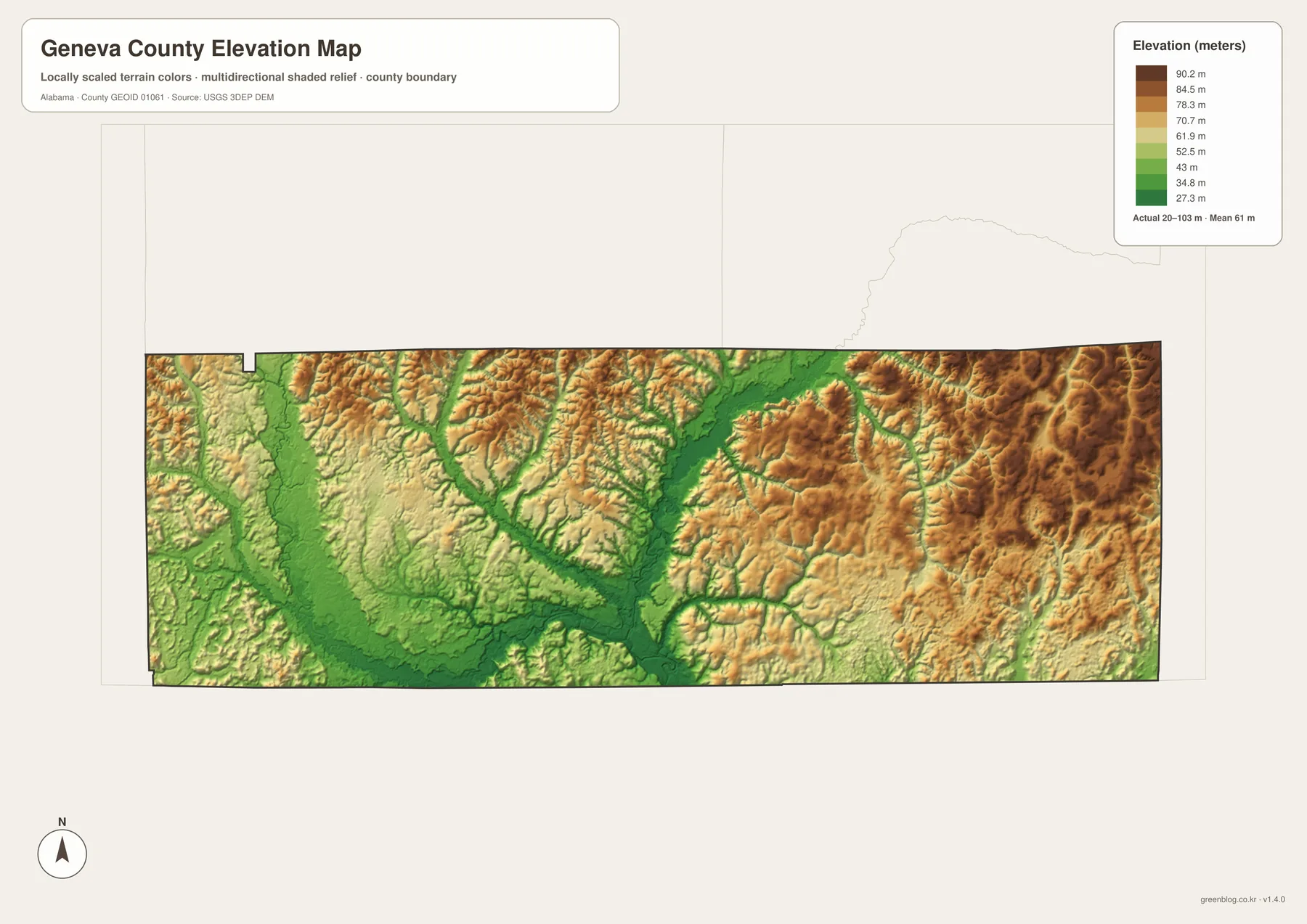
The elevation legend reports an actual range of approximately 20 to 103 meters and a mean near 61 meters. Green tones represent the lower parts of the county, while yellow, tan, and brown indicate higher ground. The broadest low area follows the south-central river valleys around Geneva and the Pea–Choctawhatchee junction. Higher colors become more extensive in the east and northeast, where closely spaced ridges and small valleys create a more textured surface.
Geneva County is not mountainous, but it is also not a featureless plain. The relief map reveals many short ridges separated by drainage channels. Slocomb and Malvern lie in a part of the county where higher rolling terrain is more common than it is beside the main river junction. The northwest also contains alternating ridges and valleys, so it would be misleading to describe the entire western half as flat. The strongest county-scale contrast is between the low river corridors and the surrounding uplands.
The relationship between water and elevation becomes clear when the two maps are viewed together. The Pea River, Choctawhatchee River, and their larger tributaries occupy green corridors, while smaller streams cut back into higher terrain. Roads that appear to bend on the county map may be responding to those valleys, creek crossings, and ridges. The elevation sheet is therefore useful for explaining why the transportation pattern is not a perfect grid, even though it does not contain road names itself.
The colors are locally scaled to make differences within Geneva County visible. A brown area on this sheet should not be assumed to have the same absolute height as a brown area on a map of a different county. The surface is also generalized for county-wide viewing. It cannot determine the exact elevation or slope of a house lot, establish a building pad, design drainage, or replace a professional survey. Detailed USGS data or field measurements are necessary for engineering and property decisions.
For a report or lesson, pair the elevation map with either the city or water map. Placing Geneva and the river junction over the lowest terrain helps explain the settlement’s physical setting. Comparing that low corridor with the higher eastern side gives Slocomb and Malvern a clearer regional context. The original JPG preserves the small shaded ridges better than the compressed preview and is the better choice for A3 printing.
Choose a map for roads, towns, water, or terrain
Start with the general county map when you need the broadest reference. It combines the boundary, state routes, waterways, nearby counties, and a larger set of community labels. The city map is better for a clean comparison of Geneva, Hartford, Slocomb, Malvern, Samson, and Black. It reduces background detail so the settlement pattern can be understood quickly in a presentation or classroom handout.
Choose the water map when the Pea River, Choctawhatchee River, tributaries, or the Geneva confluence are the main subject. Choose the elevation sheet when the question concerns low valleys, rolling uplands, or the relationship between drainage and terrain. Using two maps together often works better than trying to force every fact onto one page. The city and elevation sheets make a useful pair for settlement geography, while the county and water sheets work well for roads, bridges, and river orientation.
- Boundary, roads, and neighboring areas: county map
- Six principal towns and relative ranking: city map
- Rivers, creeks, and the confluence: water map
- Low valleys and higher rolling terrain: elevation map
Each image remains a general county reference. The road map is not a parcel or right-of-way record, the city graphic does not calculate driving distance, the water sheet is not a flood or navigation chart, and the elevation surface is not survey-grade. Those limits do not reduce the value of the set; they clarify the tasks for which the maps are designed, including printing, local orientation, geographic comparison, and educational use.
The WebP images above are optimized for quick browser viewing. The JPG archive is the better option when you need to zoom into route shields, creek names, town labels, or fine terrain shading, and it preserves enough detail for A3 printing. All four originals are packaged together, so the complete county set can be stored with one download and reused for different tasks.
Frequently Asked Questions
Why is Geneva the best starting point on the county map?
Geneva is the county seat, a road junction, and the principal town nearest the meeting of the Pea and Choctawhatchee rivers. Once it is located, route 52 can be followed west toward Samson and northeast toward Hartford. Slocomb and Malvern can then be placed farther east, with Black toward the southern side. The same starting point also links the city map to the water and elevation maps, making it easier to compare settlement, drainage, and low terrain.
Why does the river junction matter to the history of Geneva?
The confluence supported early trade and river movement before modern highways shaped the county. Geneva developed near that location, but a severe flood in 1861 led the community to rebuild on higher ground. Robert Fowler Memorial Park now provides a recognizable public landmark close to the meeting of the rivers. Together, the water and elevation maps show why the city remains associated with the junction while its main built-up area sits above the lowest valley floor.
Can the water or elevation map be used for flood, property, or construction decisions?
No. The water map identifies broad river and creek locations but does not show current flood probability, depth, safe navigation, ownership, or access rights. The elevation graphic summarizes county-wide terrain over an approximate 20-to-103-meter range; it cannot provide the precise height or slope of a parcel. Floodplain review, real-estate decisions, drainage design, road construction, and building work require current authoritative datasets, local regulations, and professional surveying where appropriate.
Map File Information
Geneva County high-resolution A3 maps
- Included Files: 4 high-resolution A3 JPG map files shown in this article
- File Type: JPG files in a ZIP archive
- Intended Use: Printing, education, presentations, and map-based projects
Related Maps
Sources and further reference
This rewrite uses the four supplied map previews and the county-specific material packaged with the existing article. The official links below are useful when a current statistic, a local history detail, or a more specialized hydrography or elevation dataset is needed.
- U.S. Census Bureau QuickFacts – Geneva County, Alabama
- Geneva County official website
- City of Geneva history and geography
- City of Geneva – Robert Fowler Memorial Park
- USGS National Hydrography
- USGS 3D Elevation Program
Green Map creates custom-edited map images using open geographic data sources such as geoBoundaries, Natural Earth, OpenStreetMap, and government open data. These maps are edited visual materials, not raw data files, and are provided for education, documents, presentations, and graphic reference.