The Gadsden County Map is easiest to read by starting with Quincy and then separating the county’s road directions from its two major water settings. US 90 links Midway, Quincy, Gretna, and Chattahoochee across the county, while State Road 12 bends from Havana through Quincy toward Greensboro. The western side approaches Lake Seminole and the Apalachicola River system, whereas the southeastern side drains through the Little River toward Lake Talquin and the Ochlockonee River. This page uses the county, city, and water maps supplied in the package. Download the high-resolution A3 JPG map ZIP from the file box below when you need the full-size versions of all three maps.
Table of Contents
Quincy and US 90 Provide the Simplest East-West Reference
Quincy sits near the center of the general county map and works well as the first road reference. Following US 90 west leads through Gretna toward Chattahoochee, while the same highway runs east through Midway toward Leon County and Tallahassee. The communities are separated by substantial rural space, but their order becomes clear once US 90 is treated as the baseline rather than trying to memorize each county boundary shape.
Havana occupies a different road setting northeast of Quincy, where US 27 and State Road 12 meet. SR 12 then curves southwest through Quincy and continues toward Greensboro. This is why Havana and Greensboro can share the same route while lying on opposite sides of the county seat. SR 65 leaves the Quincy area toward Liberty County, and SR 267 helps connect the central county with the Lake Talquin side.
I-10 crosses the southern half of Gadsden County but does not replace US 90 as the best local reference for the older municipal centers. Midway is relatively close to the eastern county line and interstate access, whereas Quincy, Gretna, and Chattahoochee are more directly read along US 90. Thinking of I-10 as the regional through route and US 90 as the settlement corridor keeps the road geography straightforward.
Six Municipalities Occupy Different Road Corridors
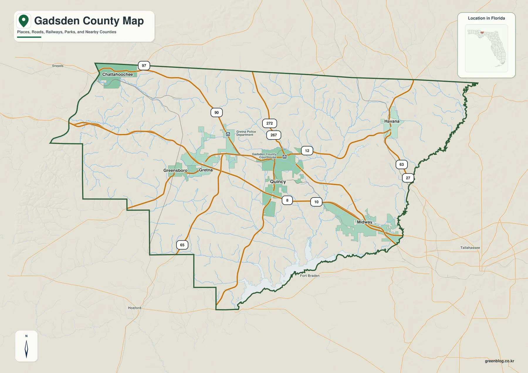
The official Gadsden County municipalities list supplied in the package identifies four cities—Quincy, Chattahoochee, Gretna, and Midway—and two towns—Havana and Greensboro. They are not arranged as one continuous urban area. Quincy is central, Chattahoochee is in the northwest, Midway is near the eastern side, Havana is northeast, and Greensboro is southwest of Quincy.
The supplied city map’s CITY INDEX lists Quincy at 7,942, Midway at 3,511, Chattahoochee at 2,979, Havana at 2,031, Gretna at 1,342, and Greensboro at 949. These are the values printed on the map and are best used for internal comparison because official population estimates may refer to different dates. What matters most for reading the graphic is that Quincy is the largest municipal marker while the other five are smaller centers distributed across the county.
The existing Census material gives Gadsden County a 2020 population of 43,826, 516.38 square miles of land, and a density of 84.9 people per square mile. Those figures match the map’s dispersed settlement pattern. Even though Quincy is the county seat, the county is not a single Quincy-centered suburban field; the other municipalities have their own road and border relationships.
Chattahoochee Is Close to the Lake Seminole–Apalachicola Transition
The western edge is best understood as a connected water system rather than a collection of unrelated features. The U.S. Army Corps of Engineers source included in the package explains that the Chattahoochee and Flint rivers meet in Lake Seminole and that water below Jim Woodruff Dam becomes the Apalachicola River. Chattahoochee lies close to this transition, which gives the northwest corner a very different geographic identity from the Tallahassee-facing east.
Lake Seminole and the Apalachicola River therefore belong to one continuous system across the dam. Lake Talquin, by contrast, is not the downstream continuation of Lake Seminole. It belongs to the Ochlockonee River system southeast of Quincy. Keeping these two drainage settings separate prevents the western and southeastern water features from being blended together simply because they lie near the same county.
Little River Leads Toward Lake Talquin and the Ochlockonee System
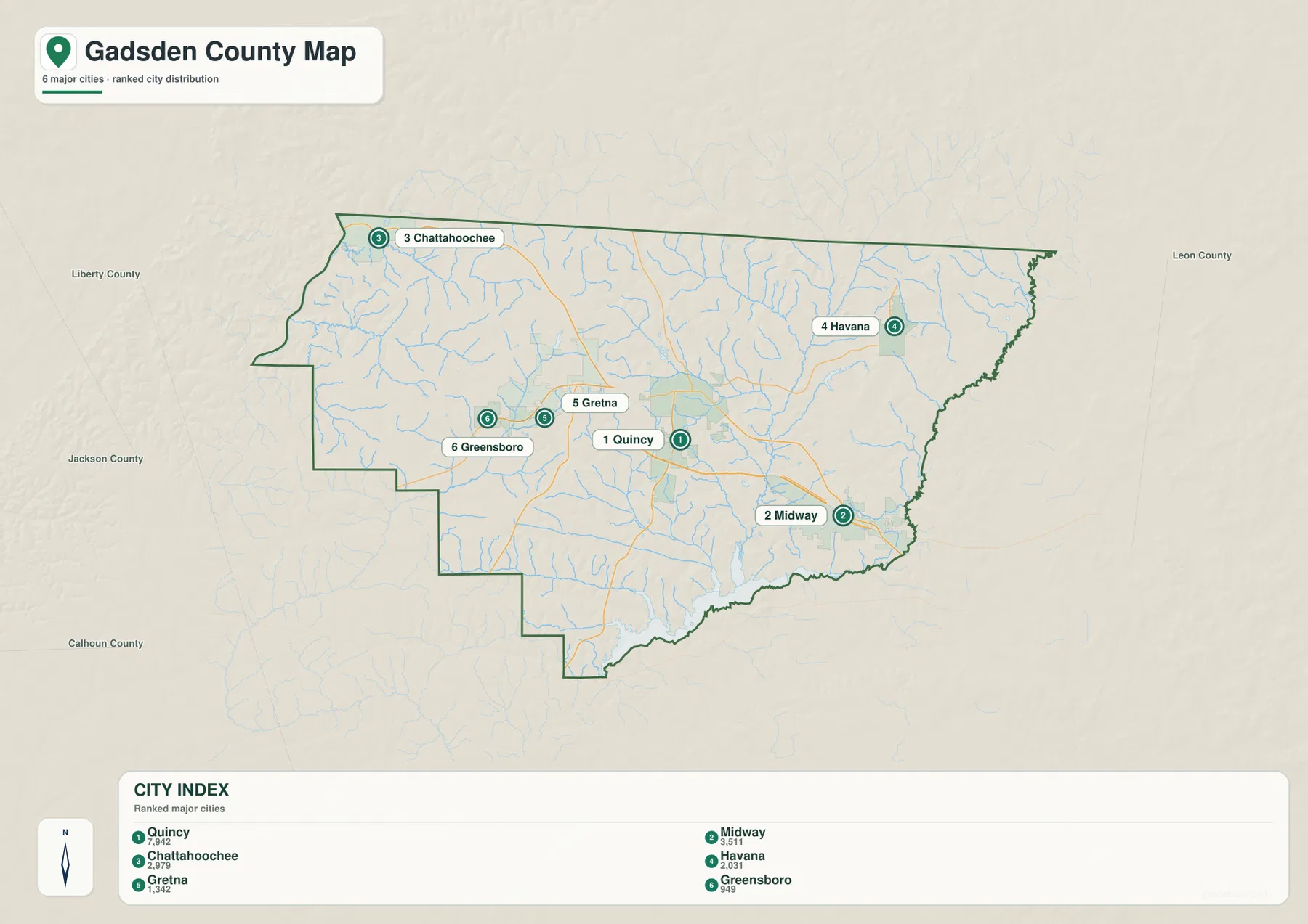
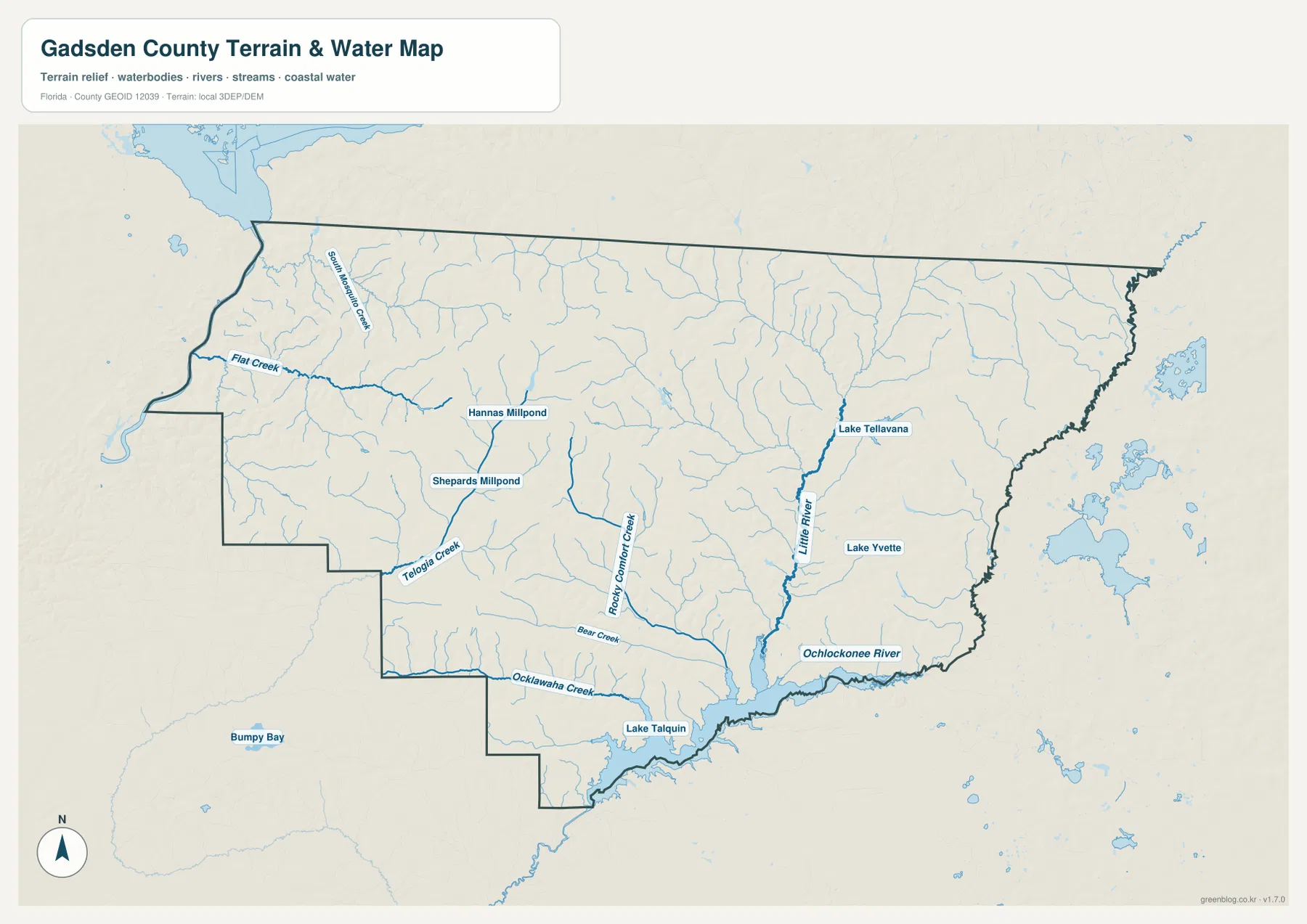
The terrain-and-water map emphasizes a dense network of small streams. Little River runs toward the southeastern side, while Lake Yvette and Lake Tellavana appear nearby. Rocky Comfort Creek, Bear Creek, Ocklawaha Creek, Telogia Creek, and Flat Creek add named references across the southern and western parts of the map. Their labels reveal a more complicated drainage landscape than the thin blue lines on the general road map suggest.
Florida State Parks material supplied with the package describes Lake Talquin as a reservoir formed on the Ochlockonee River. Its name combines Tallahassee and Quincy, which is a useful local detail for remembering the lake’s position between those two regional centers. SR 267 provides a road reference between the Quincy area and the Lake Talquin side of the county.
The Florida DEP Little River Conservation Area source describes the southeastern landscape as part of the Little River and Hurricane Creek watershed, with upland ridges, steep wooded slopes, and floodplain areas. That context helps explain why the map’s southeastern streams and roads do not form a simple flat grid. Creeks follow lower ground while roads and settlements use the surrounding higher terrain.
The Georgia Line and Tallahassee Pull Different Parts of the County
Gadsden County’s northern edge meets Decatur and Seminole counties in Georgia, while Leon County lies to the east. Havana’s US 27 connection makes the Georgia direction especially important in the northeast. Midway, by contrast, is positioned close to the Leon County side and the Tallahassee metropolitan area. These are different external relationships even though both communities occupy the eastern half of Gadsden County.
Chattahoochee faces the Lake Seminole and Apalachicola River transition in the northwest, and Greensboro follows SR 12 toward the Liberty County side. Looking at these different outward directions helps prevent every municipality from being described as a satellite of Quincy. The county seat is central, but the surrounding places have distinct road, border, and water connections.
Choose the Map by Whether You Need Roads, Municipalities, or Water
The general county map is the best single choice for Quincy, the six municipalities, US 90, US 27, SR 12, I-10, and the surrounding counties. The city map is cleaner for comparing the six municipal locations and their relative map-index sizes. The water map is more useful for Little River, Lake Talquin, the Ochlockonee River, and the named creek network across the county.
No elevation map is included in this package, so exact elevations or contour lines should not be inferred from these files. The water map is not a flood-zone, parcel-boundary, or navigation product, and the road map does not provide live traffic or construction conditions. For those questions, use current official county, transportation, water-management, or survey data.
For printing or larger documents, use the ZIP below rather than relying only on the smaller web previews. The archive contains three A3 high-resolution JPG files corresponding to the county, city, and water maps shown on this page. Each JPG can be used separately, so a classroom handout, presentation, travel note, or local-reference document can include only the map it needs.
Frequently Asked Questions
Why are Havana and Greensboro on opposite sides of Quincy if both are on SR 12?
SR 12 does not run as a simple straight east-west line. It comes from Havana toward Quincy and then bends southwest toward Greensboro and Liberty County, placing the two towns on opposite sides of the county seat.
How are Lake Seminole and the Apalachicola River connected?
The U.S. Army Corps of Engineers source in the package explains that the Chattahoochee and Flint rivers meet in Lake Seminole. Water passing through Jim Woodruff Dam continues downstream as the Apalachicola River, so the reservoir and river are parts of one connected system.
Are Lake Seminole and Lake Talquin parts of the same drainage system?
No. Lake Seminole feeds the Apalachicola River on the western side, while Lake Talquin is a reservoir on the Ochlockonee River southeast of Quincy. They belong to separate drainage systems.
Map File Information
Download one ZIP containing the three A3 high-resolution JPG files that match the county map, city map, and water map shown on this page.
- Included Files: County map, city map, and water map JPGs
- File Type: ZIP containing 3 JPG files
Related Maps
- Arcadia Roads and Peace River | DeSoto County Florida Map
- Baker County Florida Map
- Blountstown, SR 20, and the Apalachicola River | Calhoun County Florida Map
Sources
- Gadsden County official municipalities list — Quincy, Chattahoochee, Gretna, Midway, Havana, and Greensboro
- U.S. Census Bureau QuickFacts — Gadsden County — population, land area, and density reference
- Florida Department of Transportation — County General Highway Maps — US 90, US 27, I-10, and major-road reference
- U.S. Army Corps of Engineers — Lake Seminole — Lake Seminole, Jim Woodruff Dam, and Apalachicola River connection
- Florida State Parks — Lake Talquin — Lake Talquin and Ochlockonee River reference
- Florida DEP — Little River Conservation Area — Little River watershed and southeastern landscape reference
Green Map creates custom-edited map images using open geographic data sources such as geoBoundaries, Natural Earth, OpenStreetMap, and government open data. These maps are edited visual materials, not raw data files, and are provided for education, documents, presentations, and graphic reference.