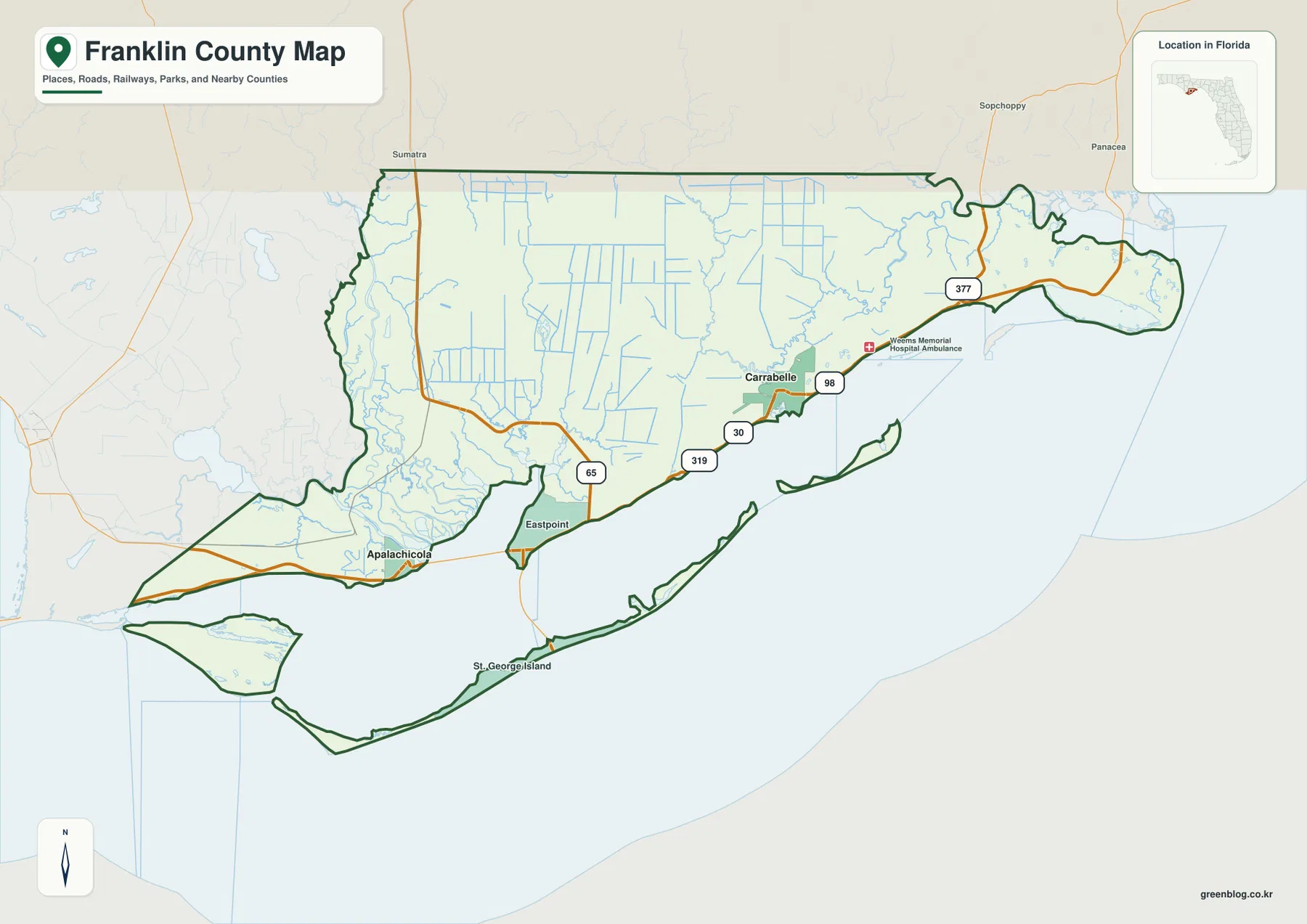
The Franklin County Florida Map is easiest to understand by following the coastal sequence from Apalachicola to Eastpoint and then east to Carrabelle. US 98 links those mainland reference points, but broad bays and river mouths make water crossings just as important as road distance. Eastpoint is especially useful because SR 65 turns north into the forest-and-wetland interior while the St. George Island bridge leaves the mainland to the south. The three supplied maps focus on county roads and places, the two incorporated cities, and the county’s river-and-bay system. Download the high-resolution A3 JPG map ZIP from the file box below when you need the full-size county, city, and water maps.
Table of Contents
Apalachicola, Eastpoint, and Carrabelle Form the Main Coastal Sequence
Franklin County stretches along the Florida Panhandle coast with Gulf County to the west, Liberty County to the north, and Wakulla County to the east. Apalachicola, the county seat, is located near the mouth of the Apalachicola River. Eastpoint sits across the broad bay-side crossing to the east, and Carrabelle lies farther along US 98 near a separate river mouth formed by the New and Crooked river system.
These three places serve different map functions. Apalachicola is the western administrative center. Eastpoint is an unincorporated community, yet it is a major directional reference because US 98, SR 65, and the St. George Island approach meet in the same area. Carrabelle is the other incorporated city and anchors the eastern side of the county near the Carrabelle River crossing. Marking the three in west-to-east order makes many smaller coastal labels easier to place.
The existing county package cites 12,451 residents in the 2020 Census, 544.98 square miles of land, and a 2025 population estimate of 13,029. Those figures fit the map’s low-density appearance. Settlement is concentrated along the coast, at river mouths, and near the island access corridor, while the northern interior is dominated by forest and wetlands rather than a dense network of towns.
Water Crossings Matter More Than Straight-Line Distance
Travel between Apalachicola and Eastpoint depends on the US 98 John Gorrie Memorial Bridge. The two places can look close across open water, but road travel is concentrated at the bridge rather than spread across the shoreline. A trip from Apalachicola to St. George Island adds a second crossing: after reaching Eastpoint, drivers turn south and use the SR 300 bridge to reach the barrier island.
SR 65 creates a completely different branch from Eastpoint. Instead of heading toward the coast, it runs north into the broad Tate’s Hell forest-and-wetland interior. Carrabelle has its own northbound connection through CR 67. Reading US 98 as the coastal baseline and then separating the two northbound forest roads from the island road makes the road pattern much easier to remember.
Alligator Point requires another change in thinking. It lies on a narrow peninsula near the Ochlockonee Bay entrance rather than on a simple continuation of the Carrabelle waterfront. Lanark Village and the St. James Island area provide eastern coastal references, but the peninsula approach should still be traced separately. On this coast, a nearby label does not always mean a direct shoreline drive.
The City Map Highlights Carrabelle and Apalachicola
The city map removes much of the secondary coastal detail and emphasizes Carrabelle and Apalachicola as the county’s two incorporated cities. Its CITY INDEX ranks Carrabelle first and Apalachicola second. Those printed map values are most useful for comparing the two city markers within the supplied graphic rather than as a substitute for the latest official population release.
Eastpoint, St. George Island, Lanark Village, and Alligator Point remain important geographic references without appearing as equivalent incorporated-city entries. Eastpoint is a road junction, St. George Island is a major barrier-island community and recreation area, and the eastern coastal communities help explain the shape of the county. The city map answers an administrative question, while the general county map does a better job showing how people actually move among these places.
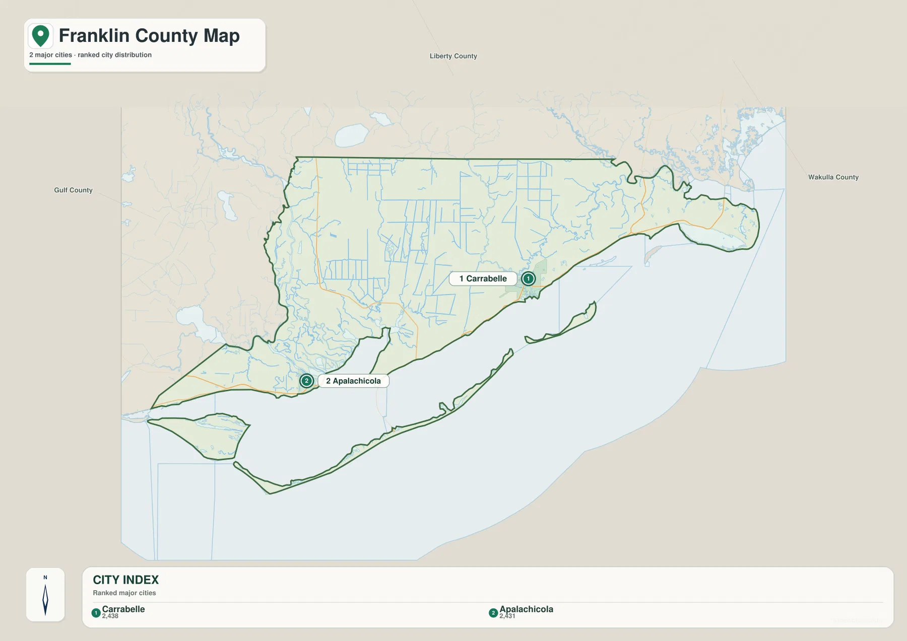
Gulf, Liberty, and Wakulla counties are labeled around the outside, giving the two cities a regional frame. Apalachicola is closer to the Gulf County side, while Carrabelle is positioned toward Wakulla County. Eastpoint and the bay occupy much of the space between them, reinforcing the idea that Franklin County is a chain of separate coastal centers rather than one continuous urban strip.
Apalachicola Bay and the Barrier Islands Define the Western Water Landscape
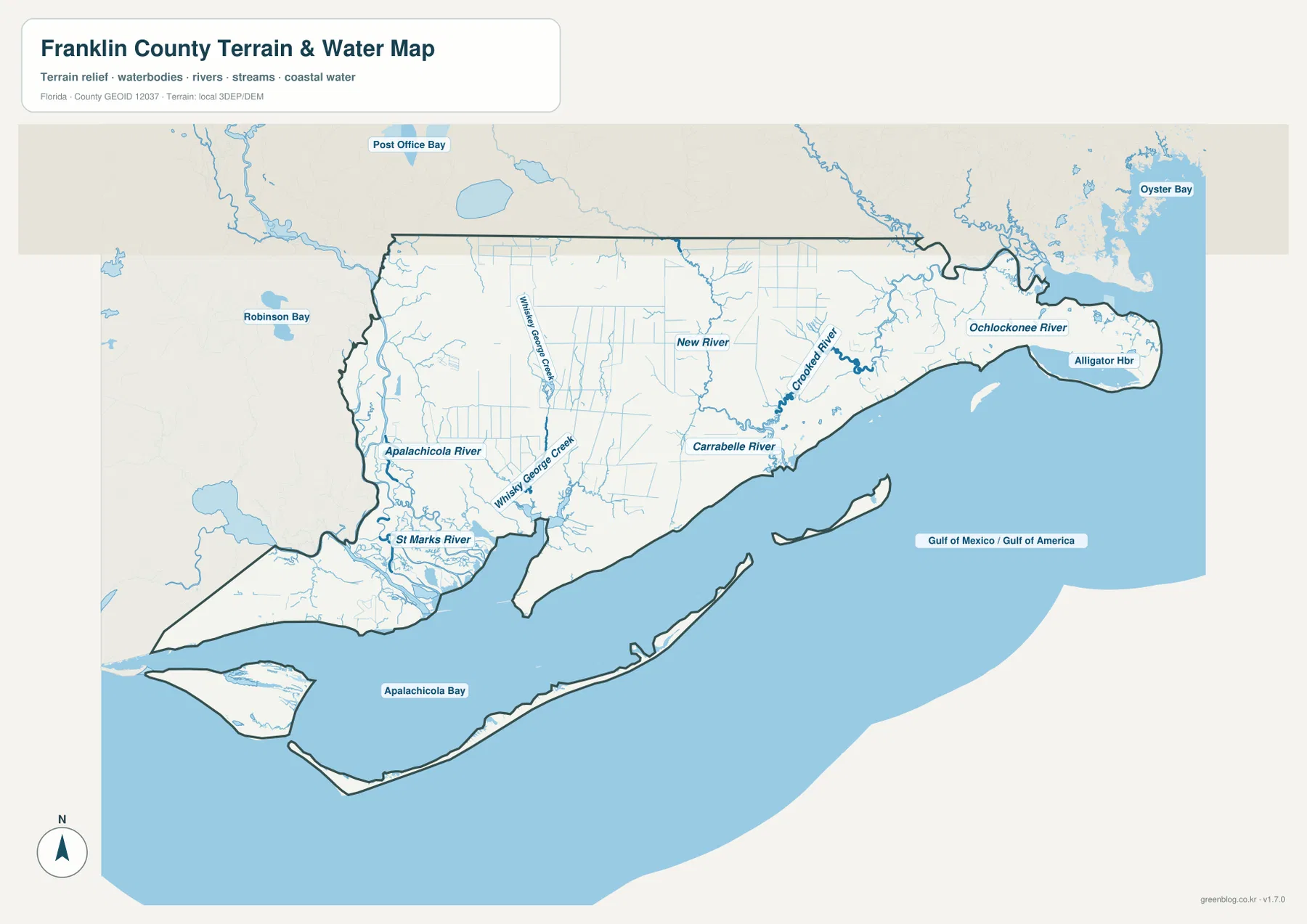
The water map gives the Apalachicola River and Apalachicola Bay the strongest visual role on the western side. Freshwater reaches the coast through the lower river and floodplain before entering the bay. St. George Island forms a long barrier between the protected bay waters and the open Gulf, creating a layered coast of river, estuary, island, and offshore water rather than a simple mainland beach.
St. George Island is road-accessible from Eastpoint, but St. Vincent Island is not. The U.S. Fish and Wildlife Service material supplied with the package describes St. Vincent National Wildlife Refuge as an island reached by boat rather than by a public road bridge. The two islands can look similar on a small map, yet their access patterns are fundamentally different.
The Florida DEP source for the Apalachicola National Estuarine Research Reserve describes a protected system that includes the lower river, floodplain, much of the bay, wetlands, and surrounding uplands. The existing package gives the reserve area as 234,715 acres. That scale explains why water and low wetland areas occupy such a large share of the map compared with the relatively compact settlements.
New River, Crooked River, and the Ochlockonee System Shape the Eastern Side
Moving east, the terrain-and-water map labels New River and Crooked River before the system reaches the Carrabelle River and coast. This gives Carrabelle a distinct estuary separate from the Apalachicola River system. The city is therefore not simply another point on the same bay; it belongs to its own river-mouth setting.
Farther east, the map labels the Ochlockonee River and Alligator Harbor. Oyster Bay also appears beyond the county edge as a regional water reference. These features show the transition toward the Wakulla County side and the complex coastal setting around Alligator Point. The peninsula sits among different bays and river outlets, so tracing the named water bodies is more reliable than assuming every eastern community faces the same bay.
Tate’s Hell Explains the Sparse Road Pattern North of the Coast
The coast receives most of the settlement attention, but a large part of Franklin County’s land area lies in the northern forest-and-wetland interior. The Florida Forest Service material included with the package describes Tate’s Hell State Forest as a 212,645-acre public forest extending through central Franklin County and into southeastern Liberty County. Wet natural communities cover a large part of the forest, and waterways such as New River and Crooked River drain the interior toward the coast.
This helps explain why the county map shows relatively few major paved roads north of US 98. SR 65 from Eastpoint and CR 67 from Carrabelle provide recognizable access lines, but the spaces between them are not missing development. They are broad forest, wetland, and drainage landscapes where road conditions and access can differ substantially from the coastal highway.
Choose the Map by Whether You Need Roads, Cities, or Water
The county map is the strongest single choice for the Apalachicola-Eastpoint-Carrabelle road sequence, St. George Island access, and the northbound SR 65 and CR 67 branches. The city map is cleaner when the goal is simply to compare the two incorporated cities. The water map is better for Apalachicola Bay, barrier islands, the New and Crooked river system, and the Ochlockonee side of the county.
No elevation map is included in this package, so exact elevations or contour lines should not be inferred from these files. The water map is not a flood-zone, parcel-boundary, or marine-navigation chart, and the road map does not provide live bridge closures, evacuation orders, wildfire restrictions, or traffic conditions. For travel and safety decisions, current county, transportation, park, and refuge information should take priority.
For printing or larger documents, use the ZIP below rather than relying only on the smaller web previews. The archive contains three A3 high-resolution JPG files corresponding to the county, city, and water maps shown on this page. Each JPG can be used separately, so you can choose the map that best fits a classroom handout, trip-planning note, presentation, or local-reference document.
Frequently Asked Questions
Why does a drive from Apalachicola to St. George Island pass through Eastpoint?
Drivers first cross from Apalachicola to Eastpoint on US 98 and then turn south to use the SR 300 bridge to St. George Island. The route uses two separate water crossings, so a straight line across the bay does not represent the actual road path.
Are St. George Island and St. Vincent Island reached the same way?
No. St. George Island has a road bridge from Eastpoint, while St. Vincent Island is a national wildlife refuge without a public road bridge and requires boat access. Their similar offshore positions do not imply the same transportation link.
Why does the city map highlight only Carrabelle and Apalachicola?
The existing Franklin County material identifies Carrabelle and Apalachicola as the county’s incorporated municipalities. Eastpoint, St. George Island, Lanark Village, and Alligator Point are still useful geographic references, but they are not equivalent incorporated-city entries on the supplied city map.
Map File Information
Download one ZIP containing the three A3 high-resolution JPG files that match the county map, city map, and water map shown on this page.
- Included Files: County map, city map, and water map JPGs
- File Type: ZIP containing 3 JPG files
Related Maps
- Arcadia Roads and Peace River | DeSoto County Florida Map
- Baker County Florida Map
- Blountstown, SR 20, and the Apalachicola River | Calhoun County Florida Map
Sources
- Franklin County official website — county seat, administrative facilities, and incorporated municipalities
- U.S. Census Bureau QuickFacts — Franklin County — population and land-area reference
- Florida Department of Transportation — Franklin County — US 98, US 319, SR 65, SR 300, and road-system reference
- Florida DEP — Apalachicola National Estuarine Research Reserve — lower river, bay, floodplain, and wetland reference
- Florida Forest Service — Tate’s Hell State Forest — inland forest, wetlands, and drainage reference
- Florida State Parks — St. George Island State Park — eastern St. George Island reference
- U.S. Fish & Wildlife Service — St. Vincent National Wildlife Refuge — boat-access island reference
Green Map creates custom-edited map images using open geographic data sources such as geoBoundaries, Natural Earth, OpenStreetMap, and government open data. These maps are edited visual materials, not raw data files, and are provided for education, documents, presentations, and graphic reference.