Coweta County sits southwest of Atlanta where fast-growing suburbs meet the rolling countryside of Georgia’s Piedmont. Newnan is the county seat and the strongest geographic reference point, while Senoia lies to the east, Grantville to the southwest, Moreland to the south, and Turin and Sharpsburg to the southeast. This page separates roads and boundaries, major-city distribution, waterways, and elevation into different map views. For printing or larger documents, you can also download one ZIP containing four high-resolution A3 JPG maps.
The county is easier to understand when roads and terrain are considered together. Interstate 85 crosses the Grantville–Newnan side and continues toward metropolitan Atlanta, while U.S. 29 and Georgia routes 34 and 16 connect older towns and east–west destinations. Numerous creeks divide the rolling uplands, and the elevation map shows higher ridges across much of the north and center with lower stream valleys toward the west and southwest. Those differences explain why one general map cannot show every useful feature clearly.
Table of Contents
Newnan, I-85, and the county road pattern
The county map makes Newnan the natural starting point. Grantville sits to the southwest, Moreland to the south, Sharpsburg and Turin to the southeast, and Senoia farther east. Haralson appears near the southeastern edge, while Chattahoochee Hills and Palmetto are labeled along the northern side. The pattern is not a single uninterrupted urban corridor; it is a central city surrounded by several smaller communities, suburban development, farms, and wooded land.
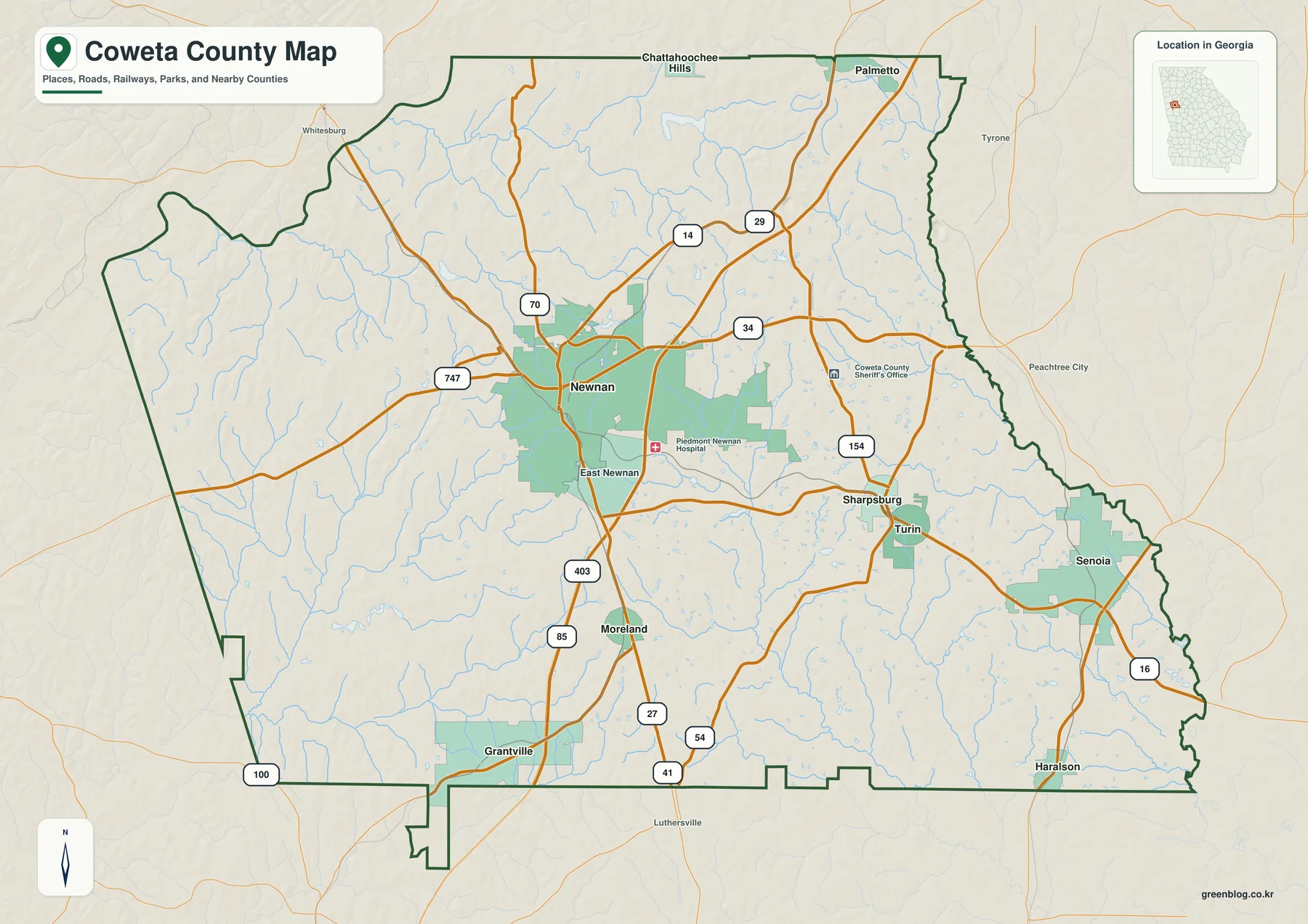
Interstate 85 is the clearest modern transportation feature. It enters from the Grantville side, passes Newnan, and continues northeast toward the Atlanta region. U.S. 29 follows a long-established town and rail corridor, Georgia 34 connects Newnan toward the Peachtree City side, and Georgia 16 crosses the county on an east–west path that links Newnan with Senoia. The map also shows several additional state routes, but the four main corridors are enough to explain why growth differs so much by direction.
Coweta County’s neighbors reinforce that transitional location. Fulton is to the northeast, Fayette to the east, Spalding to the southeast, Meriwether to the south, Troup to the southwest, Heard to the west, and Carroll to the northwest. The northeastern side therefore faces the expanding Atlanta metropolitan area, while the west and south retain more rural road patterns and larger stretches of undeveloped or agricultural land.
The verified material in the package gives a July 1, 2025 population estimate of 160,240. The county had 127,317 residents in 2010 and 146,158 in 2020, and the 2025 estimate is 9.6 percent above the 2020 estimates base. Countywide figures are useful for scale, but the map shows why one average cannot describe every part of Coweta: Newnan and the I-85 interchanges look very different from the more sparsely settled western and southern countryside.
Newnan, Senoia, Grantville, and the ranked city map
The city map highlights six major places and ranks them with the population values used for the map layer. Newnan is first at 44,235, followed by Senoia at 5,589 and Grantville at 3,251. Turin is listed at 742, Moreland at 685, and Sharpsburg at 309. These figures help show the large gap between the county seat and the smaller towns, although readers should use current Census tables when they need the newest population estimate.
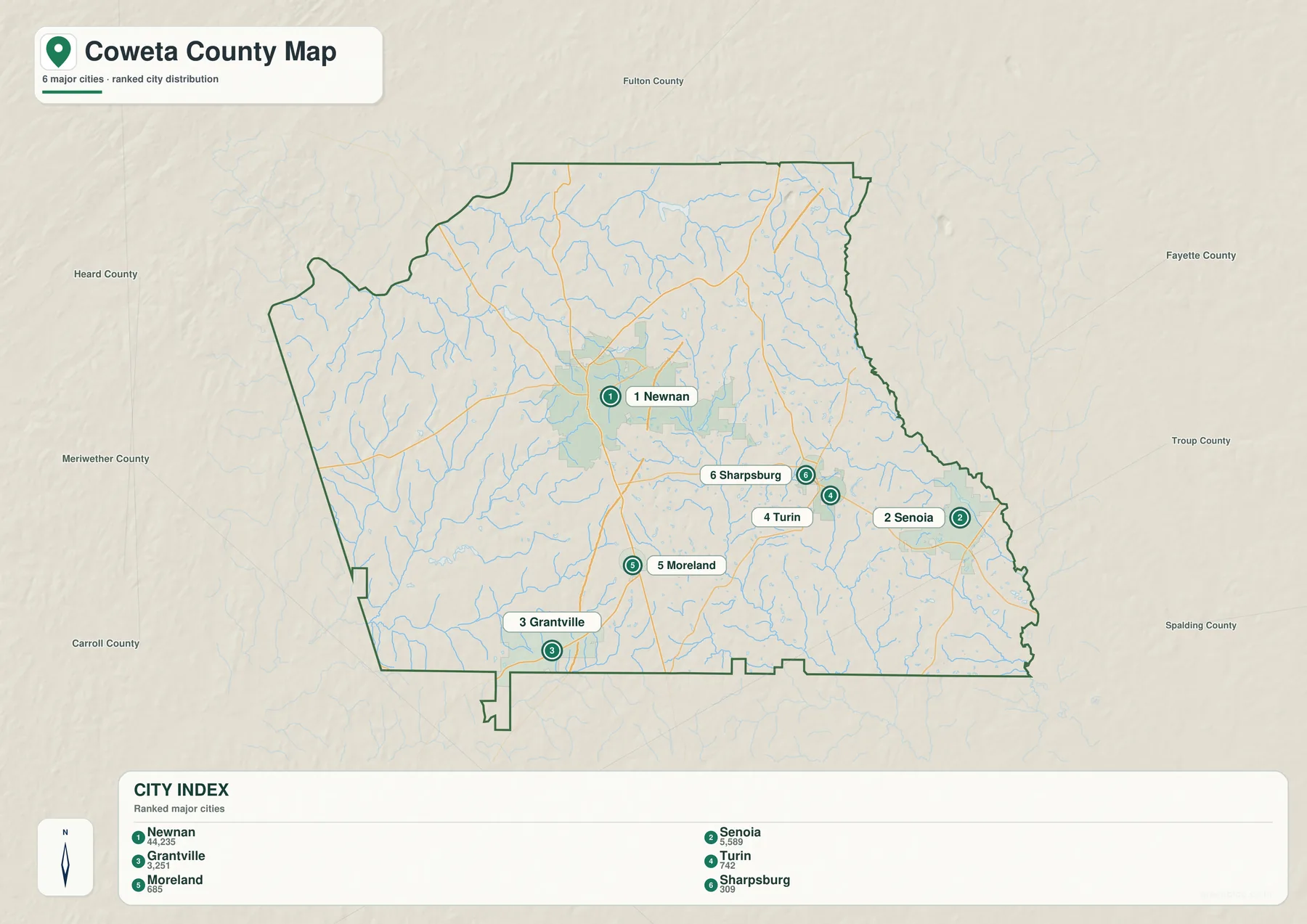
Newnan is both the county seat and the main local service center. Senoia is east of Newnan, while Grantville is southwest; Moreland lies south, and Turin and Sharpsburg are southeast. The communities branch away from Newnan in several directions instead of lining up on one road, which is why the road map is useful alongside the ranked city view.
The county’s settlement pattern has deep roots. The verified background in the package notes that Coweta County was created in 1826 and Newnan became the seat in 1828. The arrival of the Atlanta and West Point Railroad in the 1850s strengthened Newnan’s role in cotton trade and manufacturing. Modern I-85 follows a different transportation technology, but it continues the same broad tendency for accessible corridors to attract business and housing.
Senoia has a different economic identity, with its preserved townscape supporting film and television production. Newnan, meanwhile, combines health care, retail, manufacturing, and other regional services. The package’s existing Census material reports 3,020 employer establishments and 41,689 jobs in 2023, while the average commute was 29.8 minutes in 2020–2024. Those figures fit a county that has a substantial local economy but is also tied closely to jobs elsewhere in the Atlanta region.
Agriculture remains visible outside the main growth areas. The 2022 Census of Agriculture counted 324 farms and 53,189 farm acres, with $15.141 million in products sold. Crops accounted for 82 percent of sales, and nursery, greenhouse, floriculture, and sod products alone generated $8.757 million. The city map does not show farmland, but comparing it with the county map helps explain how small towns and suburban corridors coexist with a large rural land base.
New River, creek valleys, and small lakes across the county
The water map is defined less by one huge interior river than by a dense network of creeks, branches, and small lakes. New River is prominent in the southwest, Mountain Creek crosses the western side, and White Oak Creek and Little White Oak Creek run through the central and southeastern area. Shoal Creek appears in the northeast. The map also labels small water bodies including East Newnan Lake, Sullivan Lake, Lake Raymond, Clearwater Lake, and Hutchins Lake.
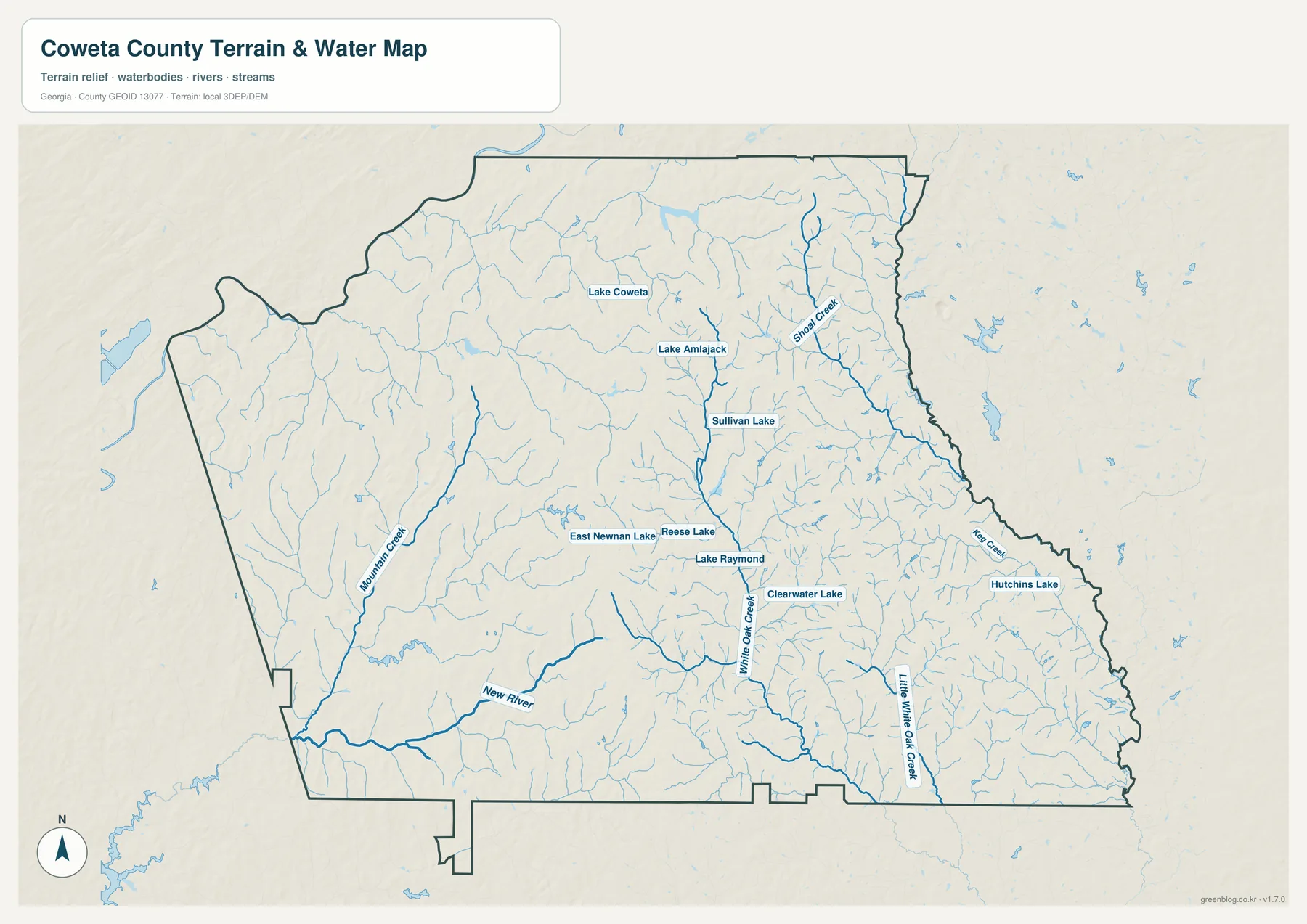
Not all of Coweta County drains in the same direction. The verified material describes a divide between the Upper Flint system on the east and the Middle Chattahoochee–Lake Harding system on the west. Western streams ultimately work toward the Chattahoochee side, while systems such as Line Creek and Whitewater Creek connect with the upper Flint drainage. That split is a useful reminder that county boundaries do not control the direction of natural drainage.
The Chattahoochee River forms an important western geographic reference even though the interior water map emphasizes creeks. Chattahoochee Bend State Park occupies 2,910 acres on a broad river bend, according to the Georgia DNR material preserved in the package. The river and low stream corridors can respond quickly to heavy rain, but this map is not a flood-hazard product. FEMA maps and current county records should be used for parcel-specific flood or development decisions.
Small lakes and tributaries matter in developed areas as well. Around Newnan, the water map shows that suburban and commercial land is still crossed by minor valleys and drainage lines. Those features help explain where water gathers after rainfall and why stormwater planning matters as roads and rooftops expand. The map, however, does not show pipe capacity, culvert condition, stream discharge, parcel ownership, or legal access.
Piedmont ridges, lower valleys, and the elevation map
The elevation layer shows that Coweta County is a rolling Piedmont landscape rather than a flat plain. Brown and orange higher ground is widespread across the north, northeast, and parts of the central county. Green lower terrain follows many western and southwestern stream valleys, with additional low corridors cutting through the southeast. The result is a repeating pattern of short ridges and creek bottoms that is difficult to see from the road map alone.
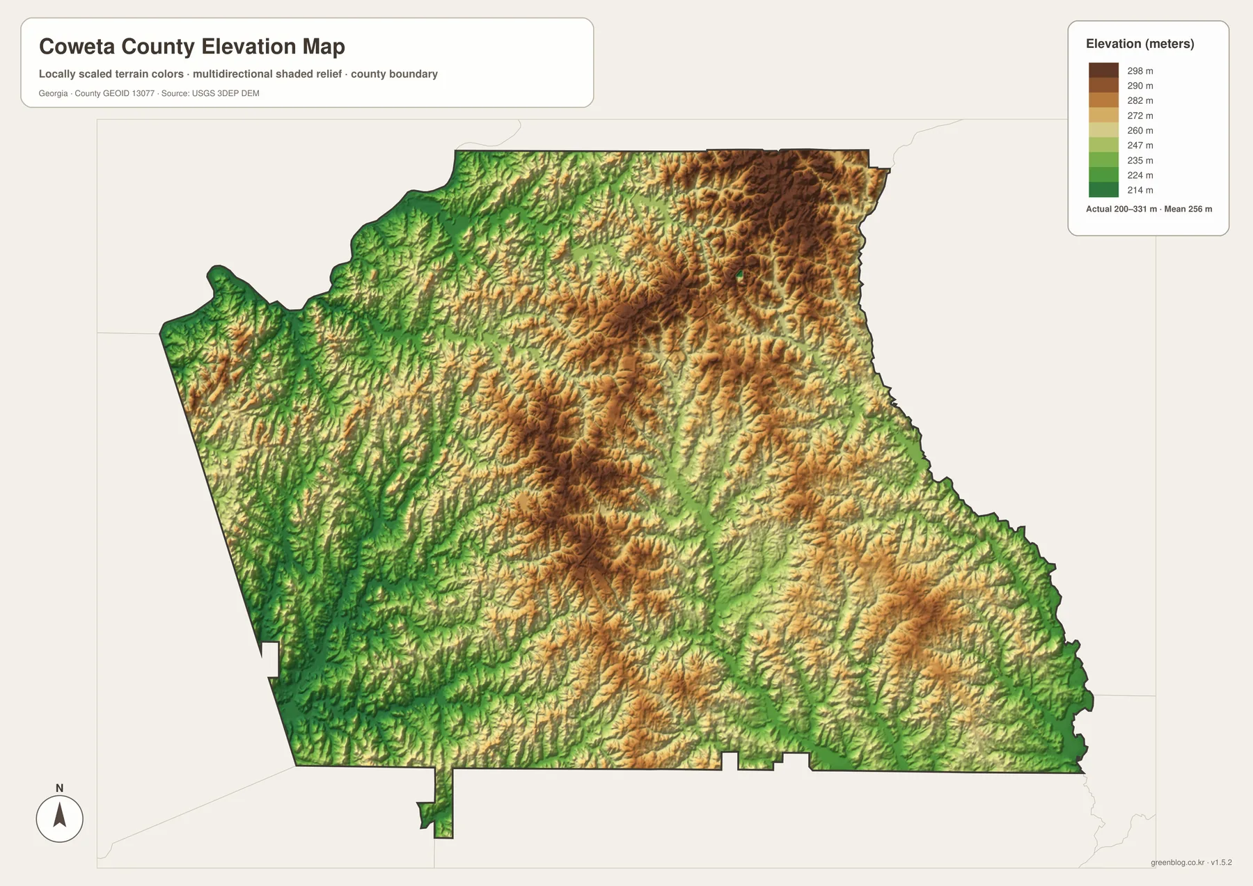
The supplied legend reports an actual range of about 200 to 331 meters and a mean of about 256 meters. Those values come from the countywide elevation surface used for this reference map. They are appropriate for comparing relative high and low areas, but they should not be treated as survey-grade elevations for an individual property. Engineering, drainage design, construction, or precise site work requires source elevation data or a professional survey.
Comparing the elevation and water maps makes the relationship between terrain and drainage clearer. New River, Mountain Creek, and the White Oak Creek system occupy lower corridors, while higher ridges separate neighboring drainage areas. The map cannot calculate flood probability or road grade, but it does show why water moves through a branching network instead of across a broad flat surface.
The Piedmont setting also appears in local natural areas. Existing Georgia DNR material describes granite outcrops along the Flat Rock Trail at Chattahoochee Bend State Park, together with pine-oak forest. That landscape is a useful contrast to the suburban image of eastern Coweta: within the same county, I-85 growth areas, wooded uplands, farms, rock outcrops, and river valleys all occur within a relatively short distance.
How to combine the four map views
For general orientation, begin with the county map and locate Newnan relative to I-85 and the surrounding towns. Then use the city map to compare the directions and relative size of Senoia, Grantville, Moreland, Turin, and Sharpsburg. The water map is the better choice for New River, creek valleys, and local lakes, while the elevation layer helps explain which parts of those drainage corridors are lower than the surrounding ridges.
A southwest trip from Newnan is a simple example. The county map highlights I-85 and Grantville; the water map adds New River and smaller tributaries; the elevation map shows lower stream corridors cutting through rolling uplands. Looking east instead brings Senoia, Georgia 16, and the upper Flint side of the drainage divide into the picture. The different layers answer related questions without forcing every feature into one crowded image.
- Orientation: Use the county map for Newnan, neighboring counties, and major roads.
- City comparison: Use the ranked map for Newnan, Senoia, Grantville, Turin, Moreland, and Sharpsburg.
- Water geography: Trace New River, Mountain Creek, White Oak Creek, smaller tributaries, and local lakes.
- Terrain comparison: Use the elevation layer to distinguish higher northern and central ridges from lower stream valleys.
- Large-format use: Download the ZIP when you need the four high-resolution A3 JPG originals.
These files are suitable for general reference, lessons, presentations, local orientation, and printed handouts. They are not replacements for parcel surveys, zoning decisions, school-zone maps, election boundaries, flood studies, engineering elevations, or current turn-by-turn navigation. For those uses, consult the responsible county, state, or federal agency.
Frequently Asked Questions
Where are Senoia and Grantville relative to Newnan?
Senoia is east of Newnan, while Grantville is southwest. Moreland lies south, and Turin and Sharpsburg are southeast, so the main communities branch away from Newnan in several directions.
Does all of Coweta County drain to the Chattahoochee River?
No. The western part generally belongs to the Chattahoochee side, while part of the east drains toward the upper Flint system. The water map helps show why two large drainage systems can cross the same county.
Can the elevation map be used for surveying or construction?
No. It is a countywide reference for relative highs and lows, not a survey-grade surface. Precise site elevations require the underlying elevation data or a professional survey.
What is included in the download ZIP?
The ZIP contains four original high-resolution A3 JPG files: a county map, a ranked city map, a water map, and an elevation map. The WebP images in the article are smaller previews for on-page viewing.
Map File Information
Coweta County Map Files
- Included Files: 4 original high-resolution A3 JPG map files shown in this article
- File Type: JPG files in a ZIP archive
- Intended Use: Printing, education, presentations, and map-based projects
Related Maps
- A Clinch County Map
- A Columbia County Georgia Map
- Adel and Little River on the Cook County Georgia Map
Sources and References
Population, history, agriculture, and park details follow the verified material included in the rewrite package. Map descriptions are based on the supplied four-map previews and their legends. Statistics and administrative records can change, so consult the current agency source when an up-to-date figure is required.
- U.S. Census Bureau QuickFacts: Coweta County, Georgia
- New Georgia Encyclopedia: Coweta County profile and history
- USDA 2022 Census of Agriculture: Coweta County profile
- Georgia DNR: Chattahoochee Bend State Park history
- USGS 3D Elevation Program
Green Map creates custom-edited map images using open geographic data sources such as geoBoundaries, Natural Earth, OpenStreetMap, and government open data. These maps are edited visual materials, not raw data files, and are provided for education, documents, presentations, and graphic reference.