You can download the Weakley County map set on this page as a ZIP containing four high-resolution A3 JPG files. Martin is the largest mapped city center in the northwest, while Dresden occupies the middle of the county as the county seat. Greenfield, Gleason, and Sharon form separate southern and western anchors, with Dukedom in the north and Palmersville toward the northeast. The pattern is dispersed rather than centered on one compact urban core.
The water and elevation maps explain another part of that layout. North Fork Obion River crosses the northern section, while Middle Fork Obion River and several creeks occupy lower corridors farther south. The mapped elevation range is about 88 to 182 meters, with a mean near 120 meters. Weakley County is not mountainous, but broad stream valleys and closely spaced low hills still shape drainage, road alignment, and the spacing between communities.
Table of Contents
Martin and Dresden anchor two different parts of the road network
Martin is the most prominent developed area on the general county map. Routes 22, 372, 216, and 45E are visible around the city, giving the northwest a strong transportation focus. Dresden is farther southeast and much closer to the center of the county. Several routes converge there or continue through it, which fits its role as county seat even though Martin has the larger city label.
South of those two centers, Sharon and Greenfield line up with routes 45, 43, and 54, while Gleason sits in the southeast near the 190 and 124 corridors. Dukedom lies close to route 118 in the northern projection, and Palmersville provides an eastern-northern reference near route 89. Together these labels show that major settlements are distributed across several separate road corridors instead of forming one continuous strip.
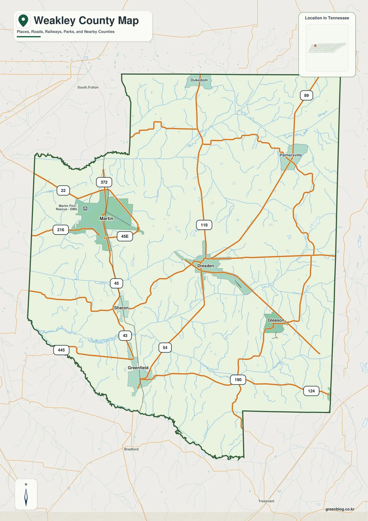
The county edges also provide useful orientation. Gibson and Obion counties lie to the west, Henry County is to the east, and Carroll County is to the south. The northern border meets the Kentucky side toward Hickman and Graves counties. South Fulton appears outside the western-northern edge on the supplied map, so it is helpful as a directional reference but should not be mistaken for a place inside Weakley County.
The city map uses Martin as the hub for four other centers
The supplied city-connections map ranks five places and uses Martin as the hub. Martin is labeled at 10,915, Dresden at 2,943, Greenfield at 2,264, Gleason at 1,159, and Sharon at 1,036. Direct-distance lines show Dresden about 9 miles from Martin, Greenfield about 12 miles, Gleason about 16 miles, and Sharon about 7 miles. These are map comparison values, not driving distances or a replacement for current official population tables.
The directions are equally useful. Dresden lies southeast of Martin, Sharon is to the south, Greenfield extends farther south, and Gleason is well to the southeast. This creates a wide fan of settlement directions from the Martin area. The county-seat role belongs to Dresden, however, so city size and administrative status should be read as two separate facts.
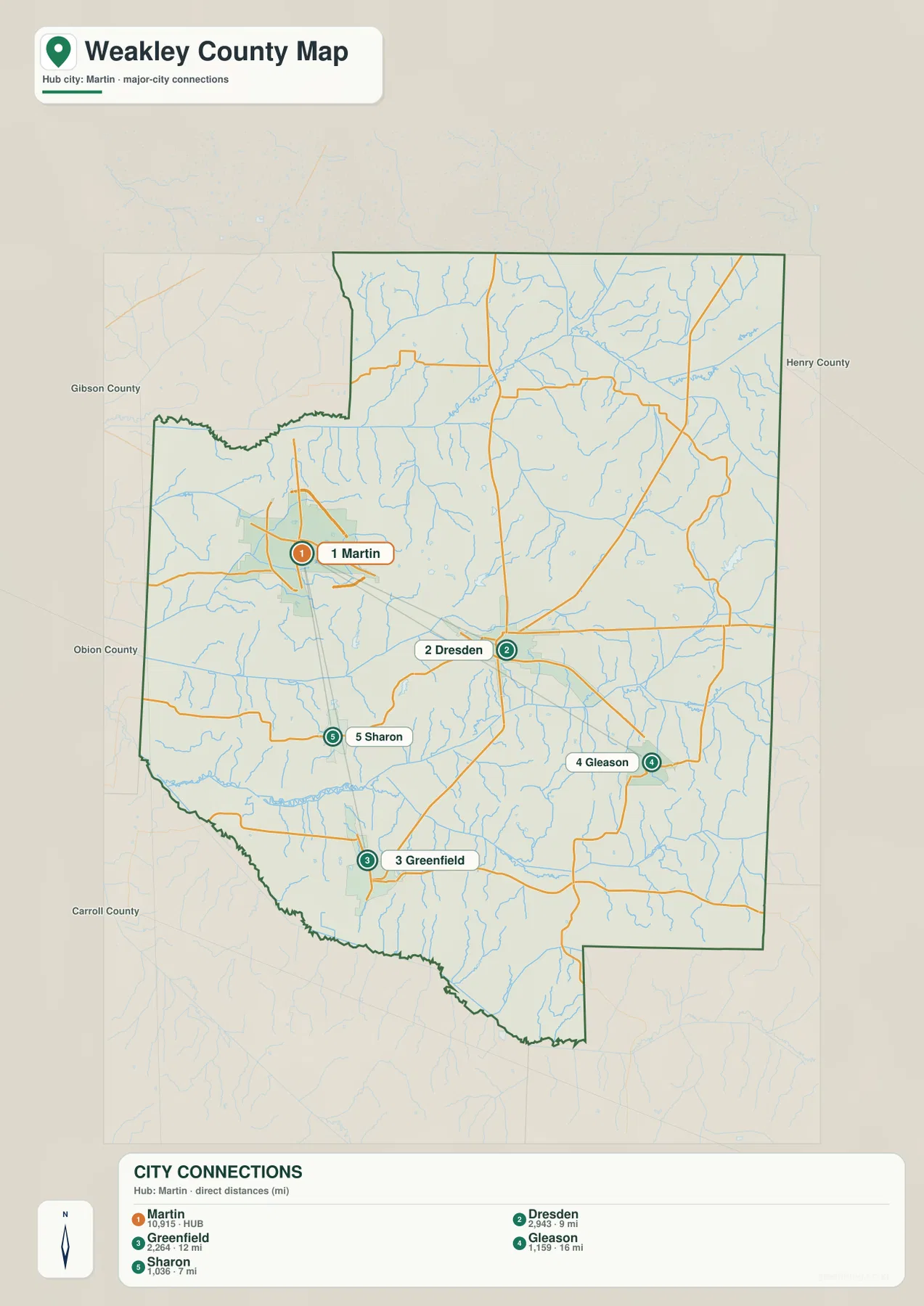
The countywide figures provide a broader scale. Existing reference data gives a 2020 census population of 32,902 and a July 2025 estimate of 33,261. Weakley County contains about 580.4 square miles of land and 1.4 square miles of water. Dividing the 2020 count by land area gives roughly 56.7 residents per square mile, but the map clearly shows that the Martin area and the broad rural interior are not equally settled.
North Fork and Middle Fork Obion River define the main drainage corridors
The strongest water label in the north is North Fork Obion River. It follows a broad lower corridor across the upper part of the county and receives many smaller branches. Middle Fork Obion River occupies another long east-west drainage farther south. Between those two systems, dozens of smaller streams create a dense pattern that explains why even a relatively low-relief county does not behave like a perfectly flat surface.
Cane Creek crosses the western interior, with Mud Creek farther south. Cypress Creek descends through the north-central area, Thompson Creek is labeled on the east, and Spring Creek appears in the southeast. Harris Pond, Gant Pond, Peelers Pond, Garrett Lake, Hodges Pond, and Muzzalls Pond add small but useful water reference points to the map.
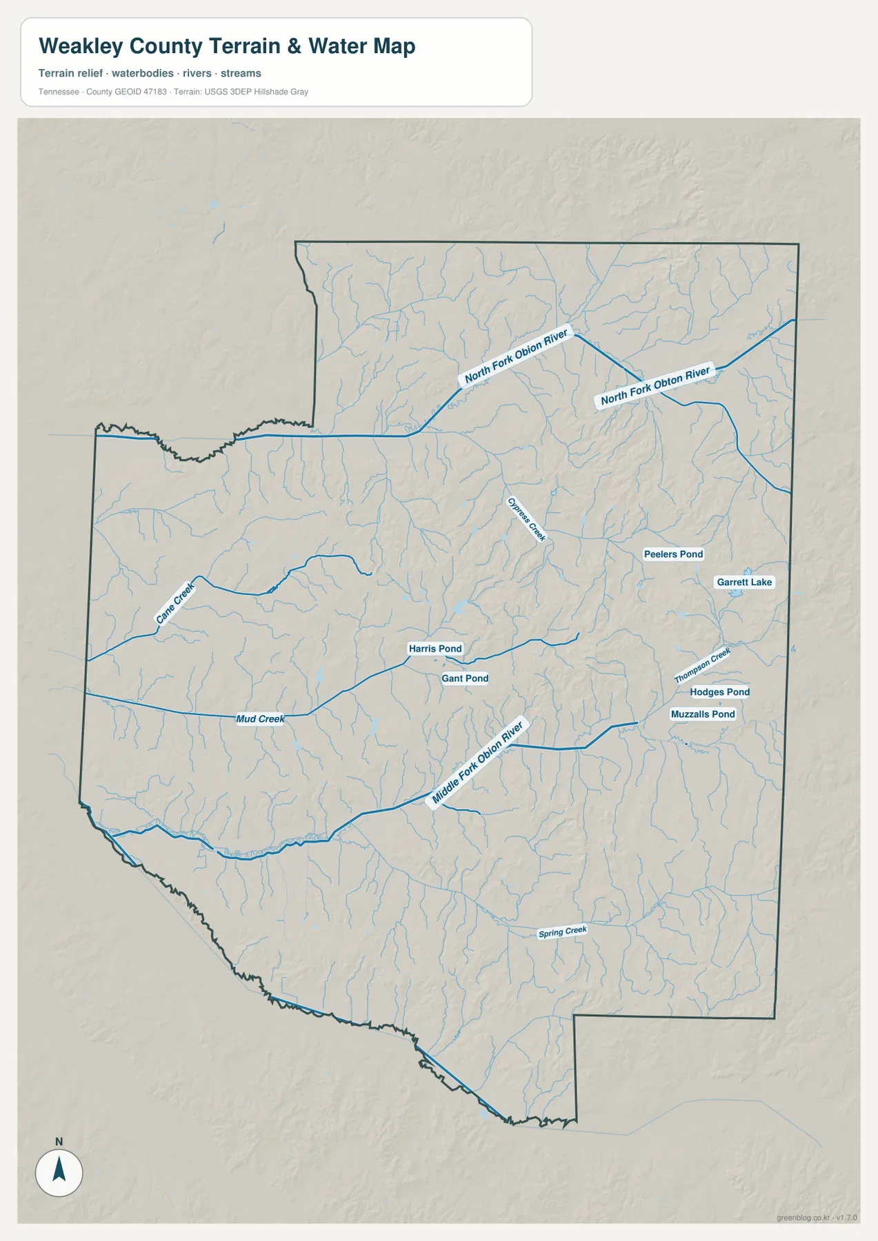
The supplied preview is most useful for the Obion River forks and individual creeks. Treating the Mississippi River as if it were a major water feature inside the county would not match what this map actually shows. This is a static geographic reference and does not provide live stream stage, flood boundaries, drainage capacity, or legal parcel information.
Elevation varies from 88-meter valleys to rolling ground near 182 meters
The elevation map gives Weakley County an actual mapped range of about 88 to 182 meters and a mean near 120 meters. The lowest dark-green terrain follows the broad western and southwestern valleys and the corridors associated with the Obion River forks. The northeast and east-central interior contain more tan and brown hilltops, creating a stronger textured pattern.
The relief is modest compared with East Tennessee mountain counties, but it still matters at local scale. Small ridges repeat across the central and eastern landscape, with creeks occupying lower green gaps between them. Farther south, several low valleys run for longer distances, while the north rises away from the North Fork Obion corridor into more rolling terrain.
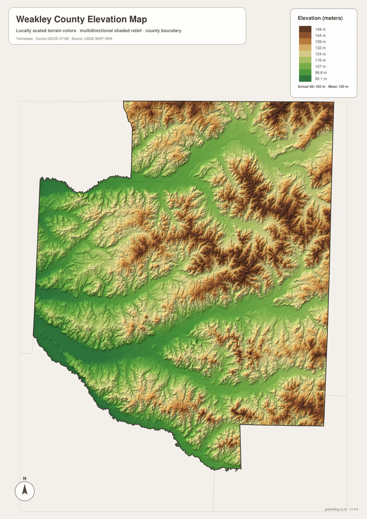
This map is intended for county-scale terrain comparison. It cannot provide an exact parcel elevation, building grade, road slope, or drainage design value. Those questions require finer elevation data or field surveying rather than the generalized colors shown here.
Roads connect the towns through a landscape divided by broad drainage valleys
The routes between Martin, Dresden, Greenfield, Gleason, and Sharon make more sense when the water layer is kept in view. North Fork and Middle Fork Obion River cross large parts of the county, so roads must use practical bridge locations and connect through lower corridors between smaller streams. The result is a network that often bends rather than following the shortest geometric line.
Dresden sits in the central portion of this network and remains the county seat, while Martin is the larger urban center in the northwest. Greenfield and Sharon anchor the southwest and south, and Gleason provides a southeastern reference. Reading those roles separately avoids the common mistake of assuming that the largest city must also be the county government’s location.
Weakley County was established in 1823, and Dresden is the county seat in the supplied reference material. The modern maps add a different layer of information: Martin has the strongest urban footprint, while several smaller towns occupy separate road and drainage corridors. The county therefore works best as a set of connected local centers rather than a single-city diagram.
Choosing the Weakley County map that fits the question
Use the general county map when you need Martin, Dresden, Greenfield, Gleason, Sharon, major roads, and the boundary in one view. The city map is quicker for comparing the five ranked settlement labels and their direct distances from Martin. The water map is the better choice for the two Obion River forks and named creeks, while the elevation map shows how the lowest drainage corridors relate to the rolling eastern terrain.
For printed notes, one copy can emphasize Martin, Dresden, the southern towns, and the main numbered roads. A second copy can mark North Fork and Middle Fork Obion River, Cane Creek, Mud Creek, and the lowest valleys. Keeping transportation and drainage partly separate makes the relationship between roads and terrain easier to see without crowding the map.
When comparing Weakley County with neighboring areas, begin with the boundary and then place the internal city labels before tracing roads and streams toward Kentucky, Obion, Gibson, Henry, and Carroll counties. This order makes outside references such as South Fulton easier to identify correctly and keeps the county map focused on features actually shown within the supplied outline.
Frequently Asked Questions
How are Martin and Dresden different on the map?
Martin is the largest mapped urban center in the northwest, while Dresden is the centrally located county seat. The supplied city graphic labels Martin at 10,915 and Dresden at 2,943, with a direct distance of about 9 miles. City size and administrative role should therefore be treated as separate map facts.
Which waterways are most important on the Weakley County water map?
North Fork Obion River in the north and Middle Fork Obion River farther south are the main drainage references. Cane Creek, Mud Creek, Cypress Creek, Thompson Creek, and Spring Creek also occupy prominent valleys. The map does not provide live flood or stream-stage information.
Where is the lowest terrain on the elevation map?
The lowest terrain is concentrated in the broad western, southwestern, and central drainage corridors associated with the Obion River system and larger creeks. The supplied map ranges from about 88 to 182 meters, with a mean near 120 meters, while the northeast and east-central interior contain more higher rolling ground.
Map File Information
The ZIP contains the high-resolution JPG originals for the Weakley County map, city map, water map, and elevation map shown on this page. The four A3-format images are better suited to printing, enlarged viewing, and annotation than the WebP previews in the article.
- Included Files: County map, city map, water map, and elevation map
- File Type: ZIP containing 4 JPG images
Related Maps
- Alamo to Gadsden: A Crockett County Tennessee Map
- Altamont, Monteagle, and Plateau Valleys — Grundy County Tennessee Map
- Around Chattanooga: Hamilton County Tennessee Map
Sources and References
- Tennessee State Library and Archives Weakley County fact sheet
- Tennessee Department of Transportation Weakley County map
- U.S. Census Bureau Weakley County QuickFacts
- USGS National Hydrography
- USGS 3D Elevation Program
Green Map creates custom-edited map images using open geographic data sources such as geoBoundaries, Natural Earth, OpenStreetMap, and government open data. These maps are edited visual materials, not raw data files, and are provided for education, documents, presentations, and graphic reference.