You can download the White County map set on this page as a ZIP containing four high-resolution A3 JPG files. Sparta occupies the central road and settlement core, while Doyle appears farther south as the second ranked city on the supplied city map. Calfkiller River runs through the central lowlands, Caney Fork River and Rocky River shape the western side, and the terrain rises sharply toward the eastern plateau. Those differences make the county much easier to understand when roads, water, and elevation are viewed together.
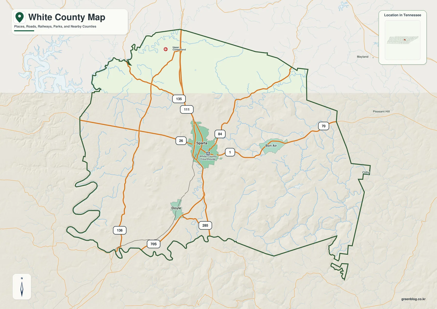
The general map shows routes 111, 135, 84, 1, 70, and 26 converging around Sparta, with 285 and 70S farther south and 136 in the west. The water map adds Calfkiller River, Cherry Creek, Taylor Creek, Clifty Creek, Caney Fork River, and several small lakes and ponds. Elevation ranges from about 193 to 614 meters, with a mean near 364 meters, creating a strong contrast between lower central-western terrain and the much higher eastern side.
Table of Contents
Sparta forms the main road center while Doyle anchors the south
Sparta is the easiest place to find on the county map. It sits near the middle of White County, the courthouse is marked nearby, and several major roads converge around the developed area. Bon Air appears to the east and Doyle farther south, giving the map useful secondary reference points without competing with Sparta as the principal county center.
Route 111 runs through the Sparta corridor in a strong north-south direction. Route 135 continues north, while 84 and 1 head east and 70 reaches toward the eastern boundary. Route 26 provides a western connection near the city. Farther south, 285 and 70S are visible, and 136 provides an important reference in the western part of the county. The roads do not create a rigid grid because rivers, valleys, and the rising eastern terrain affect their alignment.
Putnam County lies to the north, Cumberland County to the east, Van Buren County to the south, Warren County to the southwest, and DeKalb County to the west in the supplied county references. The western and southwestern boundary bends around river valleys and irregular terrain, while the eastern side reaches into higher ground. Checking the county outline directly is therefore more reliable than assigning an edge label to White County simply because it appears close to the border.
The city map reduces White County to Sparta and Doyle
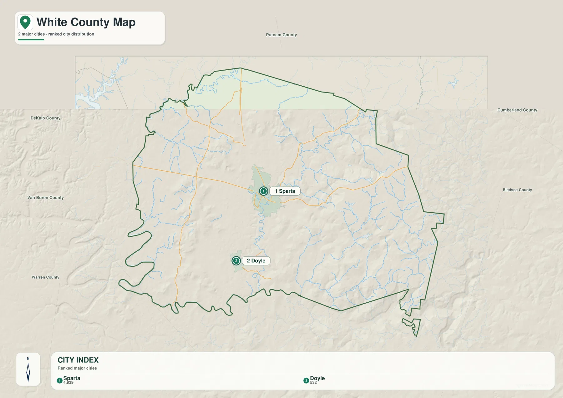
The supplied city map ranks only two places. Sparta is labeled at 4,993 and Doyle at 532, a large difference that immediately identifies Sparta as the stronger urban reference. These values belong to the provided city graphic and are most useful for comparing the two mapped centers. They are not the countywide population and should not be treated as a replacement for current official municipal estimates.
Sparta lies near the center, while Doyle is separated to the south. The road network around Sparta branches in more directions, whereas Doyle functions as a useful marker for the southern part of the county and the routes approaching the lower boundary. Reading the two together gives a simple settlement framework before the more detailed water and terrain patterns are added.
The countywide numbers tell a different story of scale. The existing reference material lists a 2020 census population of 27,351 and a July 2025 estimate of 29,612. White County contains about 376.7 square miles of land and 2.7 square miles of water. Dividing the 2020 count by the land area gives roughly 72.6 residents per square mile, but the maps make clear that population is not spread evenly between Sparta, rural valleys, and the eastern uplands.
Calfkiller River links the central valleys while Caney Fork shapes the west
Calfkiller River is the most prominent internal watercourse on the supplied terrain-and-water map. It descends from the north, passes through the central part of the county, and continues south in a series of bends. Cherry Creek joins the broader central drainage from the north, while Taylor Creek occupies a separate northwestern valley. These waterways help explain why the central corridor around Sparta is lower and more open than much of the eastern county.
The western and southwestern side is organized by larger river bends associated with Caney Fork River and Rocky River. To the east, Clifty Creek follows a long valley through higher terrain, and Doe Creek with Doe Creek Lake provides another local reference. Wonder Lake, Spain Lake, Duck Pond, and Boiling Pond are among the smaller named water bodies that make the map useful beyond the major rivers alone.
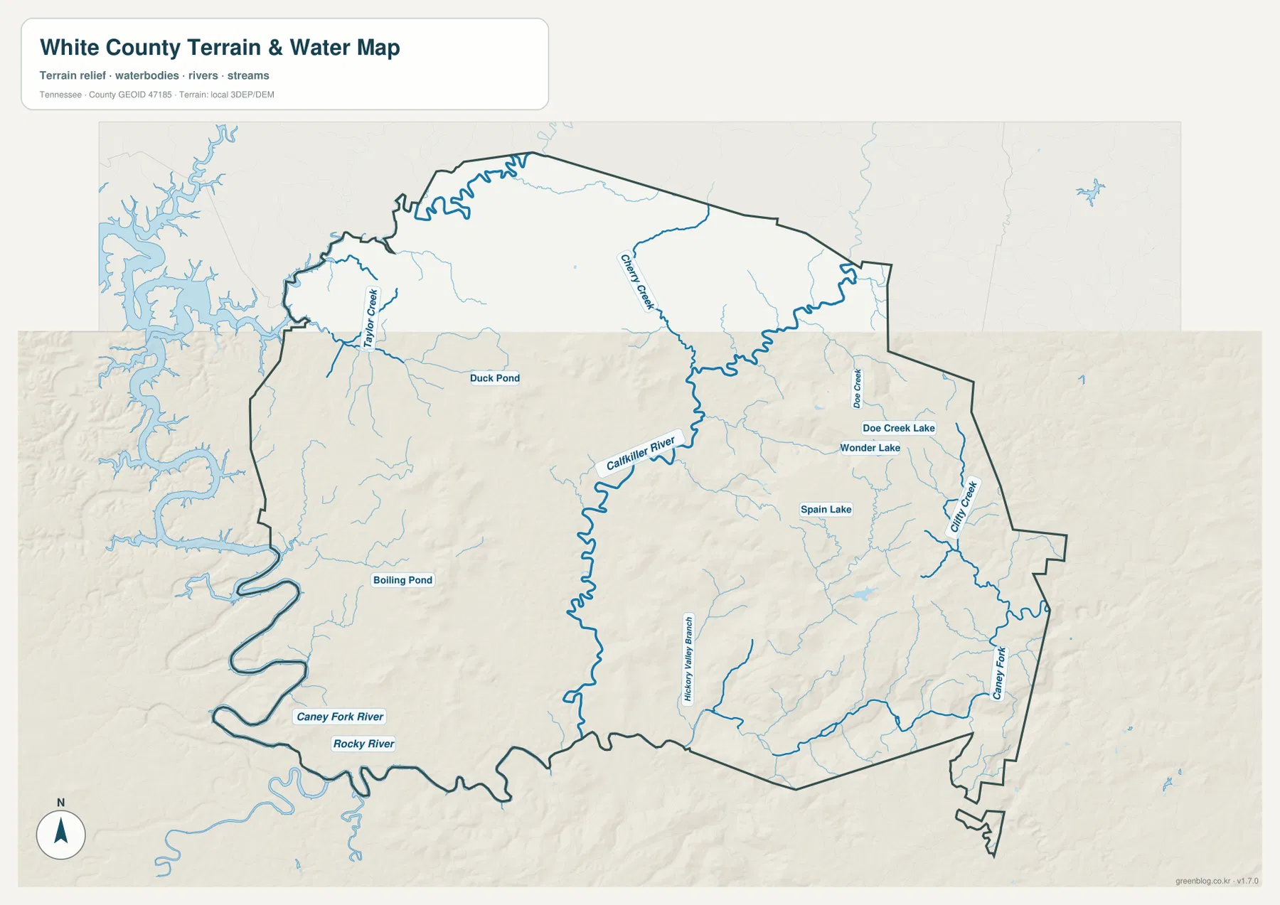
In the southeast, additional small channels occupy narrow valleys cut into the high terrain. Comparing the stream lines with the shaded relief shows water moving through lower passages rather than across the plateau at random. This is a static reference map, not a live hydrology product, and it does not show current river stage, flood boundaries, navigation depth, boating access, or legal property lines.
Elevation rises from roughly 193 meters to more than 600 meters in the east
The elevation map gives White County an actual mapped range of about 193 to 614 meters and a mean near 364 meters. Most of the west and center appears in green tones, indicating lower rolling terrain and river valleys. Moving east, yellow and brown become much more common as the surface rises into a broad highland area.
The strongest high terrain occupies the east and southeast, with additional elevated ridges in the northeast. Narrow green valleys cut into these higher surfaces wherever streams such as Clifty Creek descend through the plateau. Around Sparta and the Calfkiller corridor, the terrain is lower and more open, which helps explain why the largest settlement and the densest road network are concentrated there.
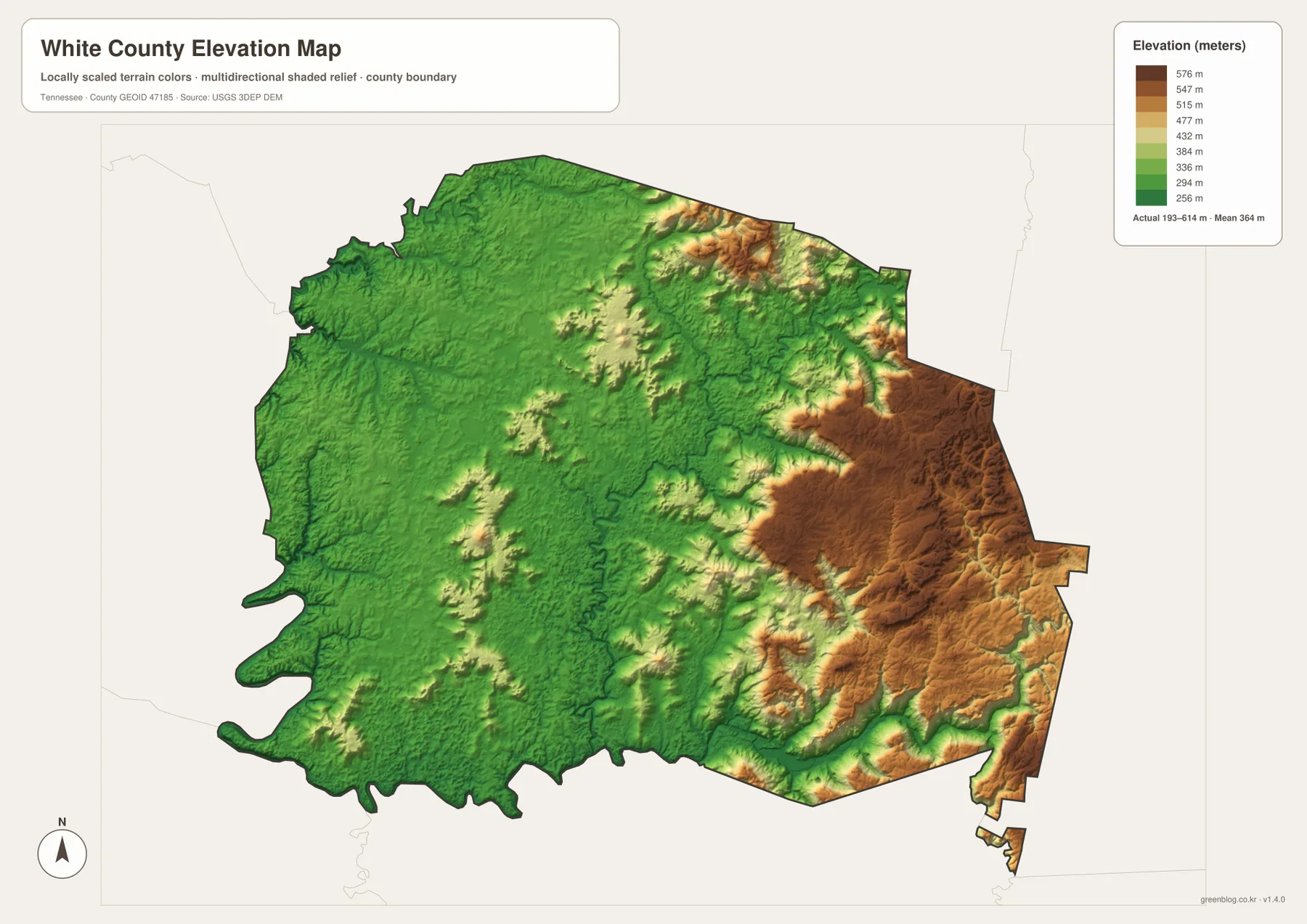
The supplied reference material identifies the Cumberland Plateau and Highland Rim as important regional terrain settings. The county-scale elevation map makes their local contrast easier to see by showing a distinct eastern rise next to lower central and western ground. The colored surface is useful for broad comparison, not for parcel surveying, construction grades, slope engineering, or an exact property elevation.
Why the main roads cluster around the lower Sparta corridor
The road concentration around Sparta becomes more logical once elevation and drainage are considered. The city sits in lower terrain connected with the Calfkiller River valley, leaving more practical space for routes to converge from several directions. Roads leaving the center can then follow lower passages before climbing toward the eastern plateau or crossing waterways farther west.
The eastern side imposes a different set of constraints. High terrain and deeply cut valleys cause roads to bend and seek gaps rather than cross every ridge directly. In the west, elevation is lower, but Caney Fork River and Rocky River can still limit where direct crossings are practical. The shortest straight line between two places therefore does not always resemble the actual road route.
White County was established in 1806, and Sparta is the county seat in the supplied reference material. The modern map reinforces that administrative role because Sparta is also the clearest road and settlement center. Large areas of eastern highland contain fewer major city labels, which is why the city map should be read together with the water and elevation layers rather than by itself.
Choosing a White County map for roads, water, or relief
Use the general county map when you need Sparta, Doyle, Bon Air, major roads, and the county boundary in one view. The city map is the quickest option for comparing the two ranked settlement centers. The water map is better for Calfkiller River, Caney Fork River, Rocky River, Clifty Creek, and the smaller lakes, while the elevation map provides the clearest explanation of the low central corridor and high eastern plateau.
For printed notes, separate transportation and physical geography instead of crowding every feature onto one sheet. One copy can emphasize Sparta and routes 111, 70, 84, and 135. Another can mark Calfkiller River, Caney Fork River, the western lowlands, and the eastern high terrain. This keeps the relationships readable without repeating the same labels in every section.
For regional comparison, first locate Putnam, Cumberland, Van Buren, Warren, and DeKalb counties around the White County outline. Then add Sparta and Doyle before tracing roads and streams toward the boundary. This sequence helps keep outside labels from drifting into the county and makes the internal road-water-terrain relationships easier to follow.
Frequently Asked Questions
How do Sparta and Doyle differ on the White County map?
Sparta is the central county seat and the strongest road and settlement hub. Doyle is the second ranked city on the supplied city map and lies farther south. Together they provide a simple framework for comparing the central administrative core with the southern part of the county.
Where does Calfkiller River run through White County?
Calfkiller River descends from the north through the central part of the county and continues south through lower terrain near the Sparta corridor. Cherry Creek and smaller tributaries connect with the same drainage system. Current flood or river conditions require live official data rather than this static map.
Why is the eastern side so much higher on the elevation map?
The eastern and southeastern parts of White County rise into a broad highland area associated with the Cumberland Plateau setting. The supplied elevation map ranges from about 193 to 614 meters, with a mean near 364 meters, while Sparta and the western river valleys occupy lower ground.
Map File Information
The ZIP contains the high-resolution JPG originals for the White County map, city map, water map, and elevation map shown on this page. The four A3-format images are better suited to printing, enlarged viewing, and annotation than the WebP previews in the article.
- Included Files: County map, city map, water map, and elevation map
- File Type: ZIP containing 4 JPG images
Related Maps
- Alamo to Gadsden: A Crockett County Tennessee Map
- Altamont, Monteagle, and Plateau Valleys — Grundy County Tennessee Map
- Around Chattanooga: Hamilton County Tennessee Map
Sources and References
- Tennessee State Library and Archives White County fact sheet
- Tennessee Department of Transportation White County map
- U.S. Census Bureau White County QuickFacts
- USGS National Hydrography
- USGS 3D Elevation Program
Green Map creates custom-edited map images using open geographic data sources such as geoBoundaries, Natural Earth, OpenStreetMap, and government open data. These maps are edited visual materials, not raw data files, and are provided for education, documents, presentations, and graphic reference.