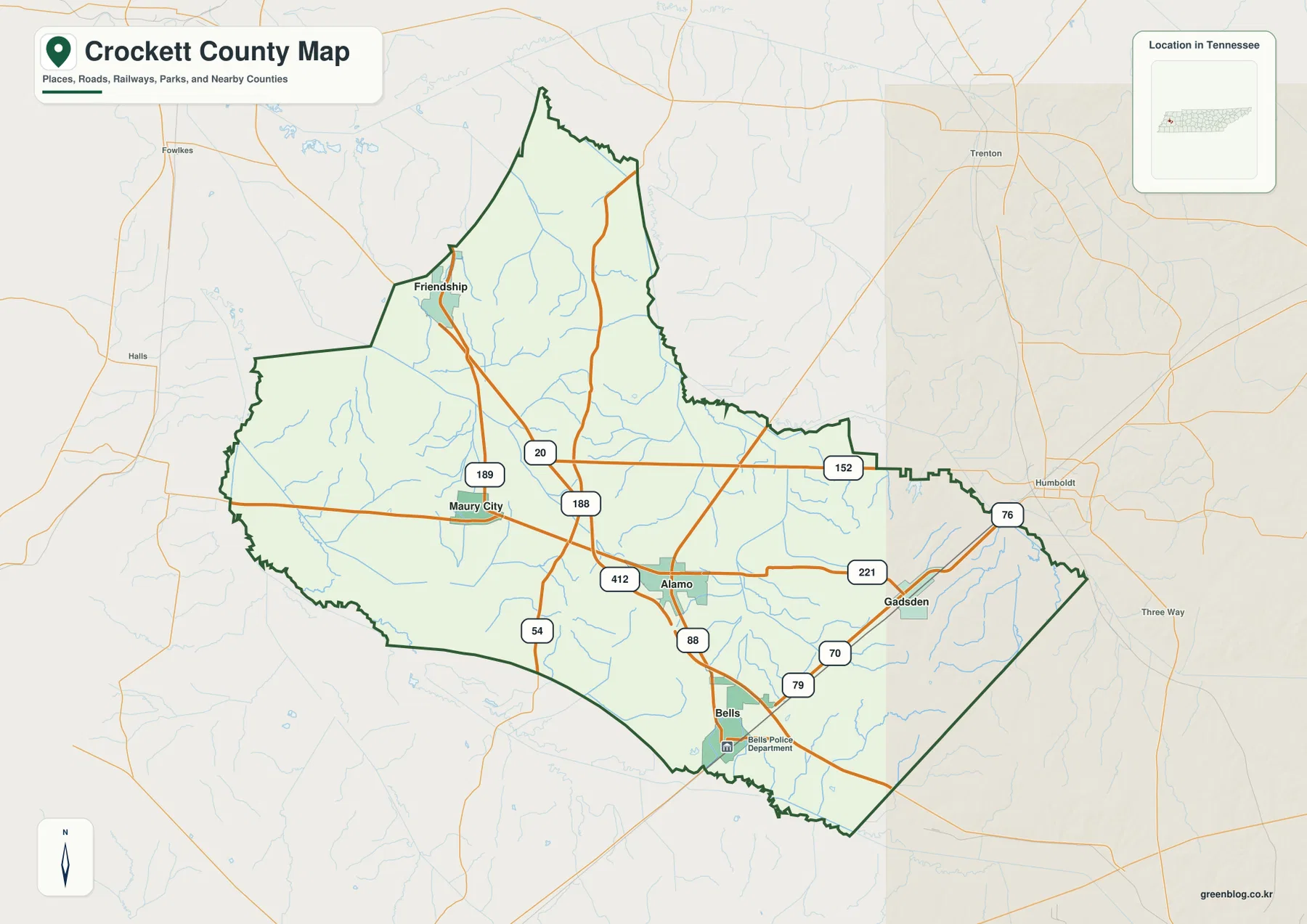
This Crockett County Tennessee Map set places Alamo, Bells, Friendship, Maury City, and Gadsden in the same county view while separating roads, waterways, and elevation into clearer companion maps. High-resolution A3 JPG files for the county, city, water, and elevation maps are available together in the ZIP download, so readers can use the on-page WebP previews for reference and keep the larger files for printing or annotation.
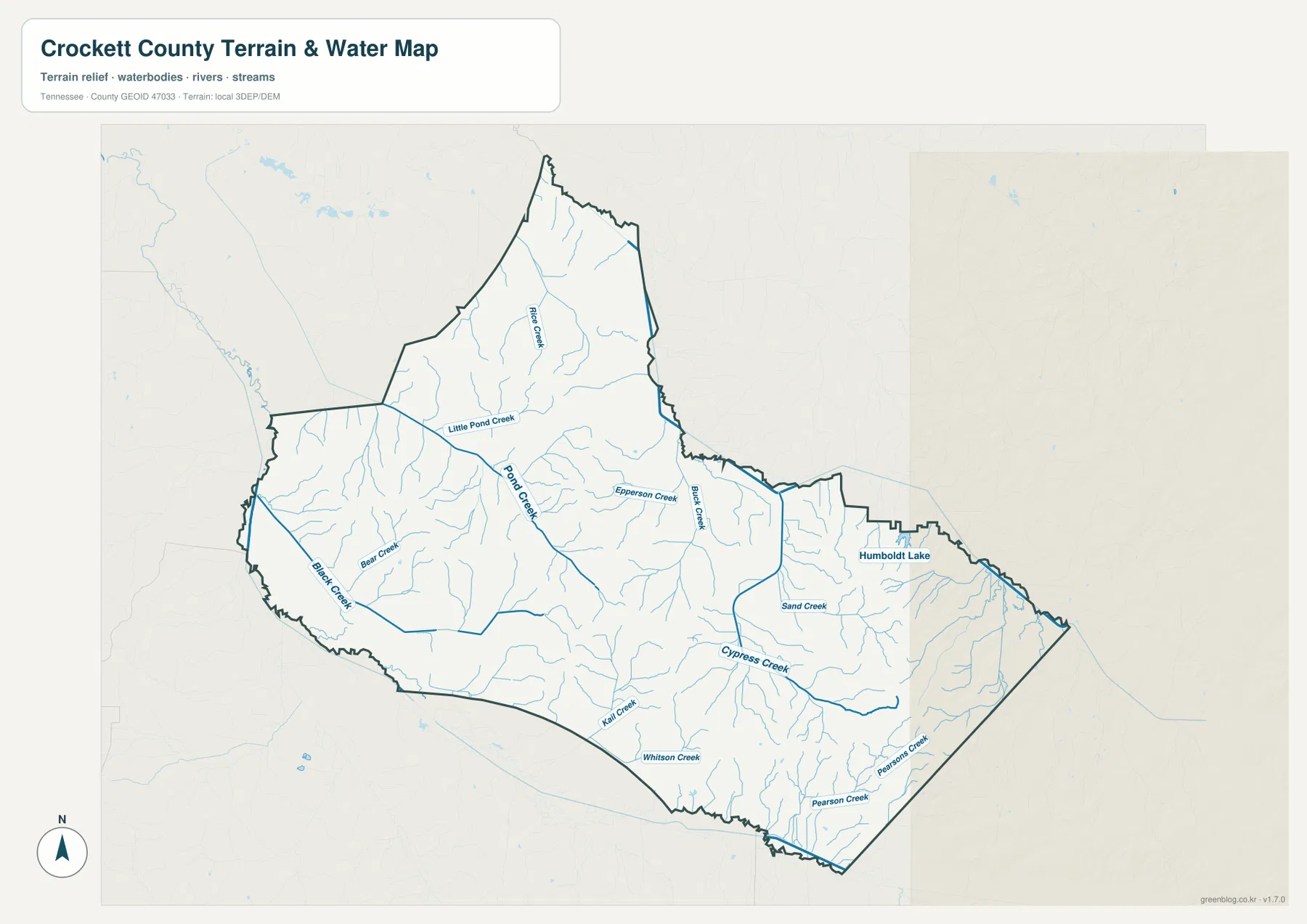
Crockett County is in West Tennessee, with Alamo serving as the county seat. The supplied county data lists 13,911 residents in the 2020 census and a July 2025 estimate of 14,006. The Gazetteer figures in the package give 265.5 square miles of land and 0.2 square miles of water. That small water-area total should not be mistaken for an absence of drainage: the water map names Pond Creek, Cypress Creek, and many smaller streams across the county.
Table of Contents
Alamo and Bells organize the central road picture
Alamo sits a little south of the county’s middle and provides the clearest administrative reference. Bells is farther south, close to the lower boundary. Route 88 runs between the two on the map, while US 412 crosses through Alamo from west to east. West of Alamo, US 412 points toward the Maury City side of the county; eastward, the same corridor reaches the vicinity of Route 221 and the approach to Gadsden.
The northwestern corner has a different road arrangement. Friendship appears near Routes 189 and 20, and Maury City lies south of it near Route 188. Gadsden occupies the eastern part of the county, where Routes 70 and 79 are also visible in the southeast. The result is not a simple spoke pattern centered on one town. Instead, the map shows several small communities tied to different crossings and county edges, which makes the shape of Crockett County easier to understand than a list of place names alone.
Bells provides a useful distance reference for the other communities
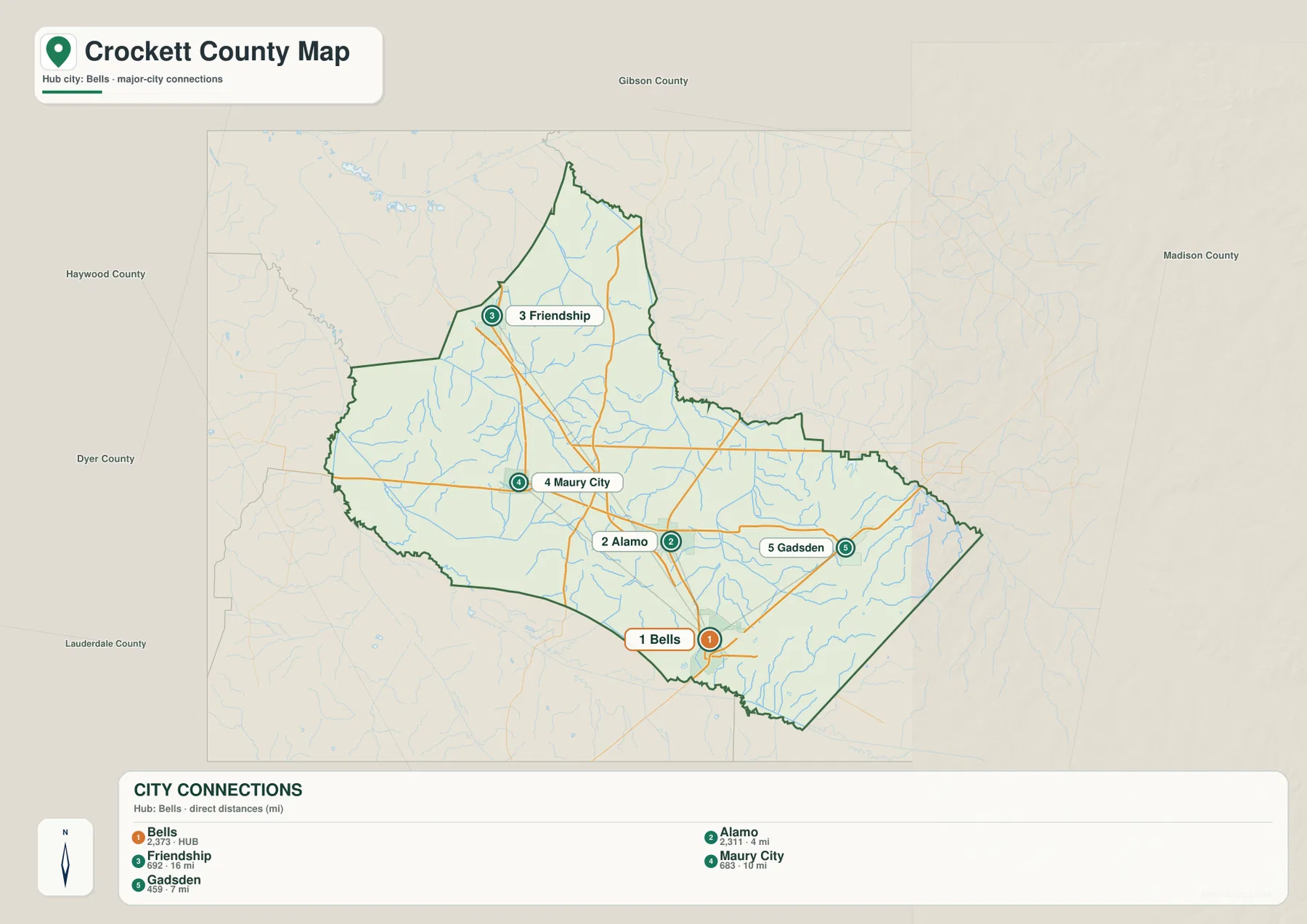
The city-connections map uses Bells as its hub and gives straight-line distances to four other labeled communities. Alamo is shown at about 4 miles from Bells, Friendship at about 6 miles, Gadsden at about 7 miles, and Maury City at about 8 miles. These are direct map distances rather than driving mileage, so they work best for comparing relative position instead of estimating a trip.
That comparison also makes the county’s internal geography easier to see. Alamo and Bells form the closest north-south pair in the set, while Friendship lies northwest, Maury City lies west, and Gadsden lies east. The map labels Gibson County to the north, Madison County to the east, Haywood and Dyer counties to the west, and Lauderdale County to the southwest. Because several Crockett County communities sit closer to one side of the boundary than to another, the neighboring county names are useful orientation marks rather than background decoration.
Pond Creek and Cypress Creek reveal the county’s drainage detail
The water map is defined more by a web of creeks than by a single large lake. Pond Creek runs through the northern and central part of the county, with Little Pond Creek joining from the northwest. Rice Creek, Bear Creek, Black Creek, Epperson Creek, and Buck Creek add named references around it. This denser stream layer changes the impression created by the road map: areas that look open at first are divided by many small channels.
Farther south and east, Cypress Creek is one of the longest clearly labeled water features. Sand Creek appears to its northeast, while Kall Creek and Whitson Creek are farther south. Pearson Creek and Parsons Creek are marked in the southeastern portion, and Humboldt Lake sits close to the eastern county edge. These labels are especially helpful when matching a road or community to a nearby drainage, because they provide local reference points between the larger towns.
A modest 81–146 meter range still creates visible relief
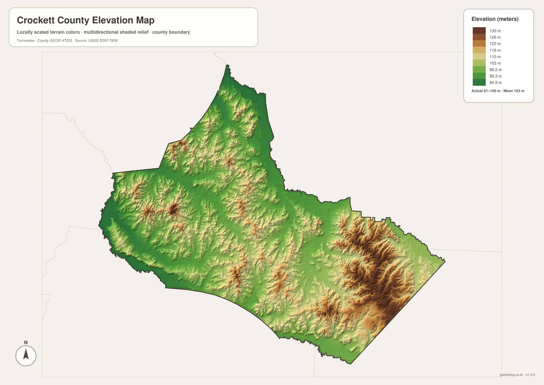
The elevation map gives an actual county range of about 81 to 146 meters, with a mean elevation of 103 meters. Crockett County therefore does not have the extreme vertical differences seen in the mountain counties of eastern Tennessee, yet the shaded relief makes clear that the land is not uniformly flat. Broad green areas cover much of the center and west, while warmer colors mark somewhat higher ridges in the southeast and smaller hills in the north.
The southeastern corner is the strongest relief feature in the image. Closely spaced ridges there stand out against the lower central ground, and a few higher patches also appear north of the county’s middle. When the elevation and water maps are compared, the contrast between lower creek country and the more pronounced southeastern hills becomes easier to see. The value of this map is not just the minimum and maximum numbers; it is the way those heights are distributed within the county outline.
Crockett County facts that help place the maps in context
| Item | Value |
|---|---|
| County seat | Alamo |
| FIPS code | 47033 |
| 2020 census population | 13,911 |
| July 2025 population estimate | 14,006 |
| Land area | 265.5 sq mi |
| Water area | 0.2 sq mi |
| Elevation shown | about 81–146 m; mean 103 m |
| Mapped communities | Alamo, Bells, Friendship, Maury City, Gadsden |
The 2025 population estimate is about 0.7 percent above the 2020 census count in the supplied material. Because one figure is a decennial census and the other is a later estimate, they should be labeled separately rather than treated as interchangeable. The package also notes that Crockett County was established in 1871. That historical fact explains the county jurisdiction, while the current maps show the modern positions of communities, roads, streams, and relief.
Choose the map by the question you need to answer
For a quick location check, the county map is the most direct because it keeps towns, numbered routes, and the boundary together. The city map is better when the main question is how Bells relates to Alamo, Friendship, Maury City, and Gadsden. The water map becomes useful when a road or place needs to be matched with Pond Creek, Cypress Creek, or one of the smaller named streams. The elevation map is the clearest choice for comparing the broad lower center with the hillier southeastern corner.
For printed work, one approach is to keep a clean A3 copy and mark a duplicate with only the features needed for the task. A classroom worksheet might highlight Alamo, Bells, Pond Creek, and the county boundary, while a local geography handout could place the county and elevation maps side by side. Keeping the four themes separate prevents the labels from competing for space on a single crowded image.
Frequently Asked Questions
Why does the city map use Bells as the hub instead of Alamo?
Alamo is the county seat, but the supplied city-connections map uses Bells as the measurement hub. That design makes the relative positions easy to compare: Alamo is shown about 4 miles away, Friendship about 6 miles, Gadsden about 7 miles, and Maury City about 8 miles by straight-line distance. The hub label is a map-design choice and does not change Alamo’s role as the county seat.
Why is the water map useful when the county has only 0.2 square miles of water?
The area total is small, but the water map shows many narrow creeks distributed across the county. Pond Creek and Cypress Creek are the most prominent named examples, joined by Little Pond Creek, Bear Creek, Sand Creek, Pearson Creek, and others. Those streams provide local reference points even though they occupy only a small share of the county’s total area.
What stands out most on the Crockett County elevation map?
The strongest contrast is between the broad lower ground through much of the center and west and the more closely ridged terrain in the southeast. The full range shown is about 81 to 146 meters, with a mean of 103 meters, so the differences are moderate in absolute height but still clear in the shaded-relief image.
Map File Information
The ZIP includes high-resolution A3 JPG files for the Crockett County county, city, water, and elevation maps. Use the larger files when you need a print-ready copy or room for your own labels and notes.
- File Type: JPG
Related Maps
Sources
County history and basic background can be checked with the Tennessee State Library and Archives Crockett County fact sheet. For roads and regional placement, see the State of Tennessee Crockett County map and U.S. Census Bureau TIGER/Line.
Population and area figures in the supplied material can be cross-checked with U.S. Census Bureau QuickFacts, the county population estimates tables, and the Census Gazetteer Files.
Green Map creates custom-edited map images using open geographic data sources such as geoBoundaries, Natural Earth, OpenStreetMap, and government open data. These maps are edited visual materials, not raw data files, and are provided for education, documents, presentations, and graphic reference.