Kane County is easiest to understand as a long north-south county with two very different sides. Along the east, the Fox River passes a nearly continuous chain of communities from Elgin and South Elgin through St. Charles, Geneva, Batavia, North Aurora, and Aurora. Farther west, places such as Hampshire, Burlington, Campton Hills, and Sugar Grove sit in a more open interior crossed by fewer major roads and many small creeks. The four maps on this page show that contrast through roads and county context, major-city distribution, waterways, and elevation. You can also download the same four maps directly from this page as high-resolution JPG files in one ZIP archive.
The Fox River is the most useful reference line for orienting yourself. It runs along the eastern side of the county and is closely matched by the main urban corridor. Major north-south and east-west roads feed that corridor from the interior. Route 47 provides a strong north-south reference in the western half, while numbered routes 64, 38, and 30 cross toward the river. I-90 marks the northern part of the county near Elgin, and I-88 crosses the south near Aurora. Reading those roads together with the river gives a quick picture of how the county is organized before looking at smaller places and tributaries.
These are not four decorative versions of one map. The county map is best for seeing roads, boundaries, and named places together. The city-distribution map strips away much of that detail so the eastern concentration of Aurora, Elgin, Carpentersville, St. Charles, Batavia, and South Elgin stands out. The terrain-and-water map follows the Fox River and tributaries such as Tyler Creek, Ferson Creek, Mill Creek, and Blackberry Creek. The elevation map then explains the larger landform pattern: higher ground occupies much of the west and northwest, while the Fox River valley forms a lower corridor on the east.
Table of Contents
A county split between the Fox River corridor and the western interior
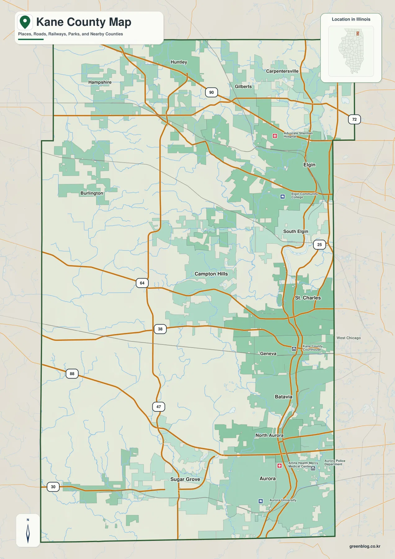
The county map makes the eastern concentration of development obvious. Elgin sits in the northeast, South Elgin follows directly to the south, and St. Charles, Geneva, and Batavia continue down the Fox River corridor. North Aurora and Aurora form the southern end of that sequence. The communities are not arranged randomly across the county. They cluster close to the river and to the denser road network on the east, while the western half has longer spaces between named places and fewer major urban blocks.
In the north, Hampshire and Huntley are separated from the denser Elgin-Carpentersville area. I-90 crosses this part of the county and becomes one of the clearest long-distance routes on the map. Route 72 provides another east-west reference near the northeast. As the roads approach Elgin and Carpentersville, they intersect a much denser set of local streets and developed areas. The pattern is better described as a gradual increase in settlement and road density from west to east than as a simple line dividing rural and urban territory.
The middle of the county is anchored by Campton Hills on the interior side and by St. Charles and Geneva at the river. Routes 64 and 38 connect those areas east to west. Geneva is also marked with the Kane County Courthouse on the map, making it an easy administrative reference point. The official Kane County Government site places the county government complex in Geneva as well. This means the county seat is not detached from the main urban corridor; it sits directly within the Fox River chain and is tied to the western interior by one of the county’s major east-west roads.
Farther south, Sugar Grove lies west of the larger Aurora area. Route 47 remains a useful north-south guide through the interior, while Route 30 and other east-west roads lead toward Aurora. I-88 crosses the southern part of Kane County and reinforces the east-west connection between the river cities and areas farther west. Looking at the whole map at once prevents Aurora from dominating the picture: the county extends well beyond the city into a broad western landscape with its own communities, roads, and drainage network.
This map is meant for county-scale orientation rather than turn-by-turn navigation. It works best when you need to answer basic questions such as which towns are close to the river, which roads cross the county, or how far the western communities sit from the urban corridor. For that purpose, the contrast between the Fox River side and the interior is more informative than a long list of individual streets.
Elgin to Aurora: where the largest mapped cities cluster
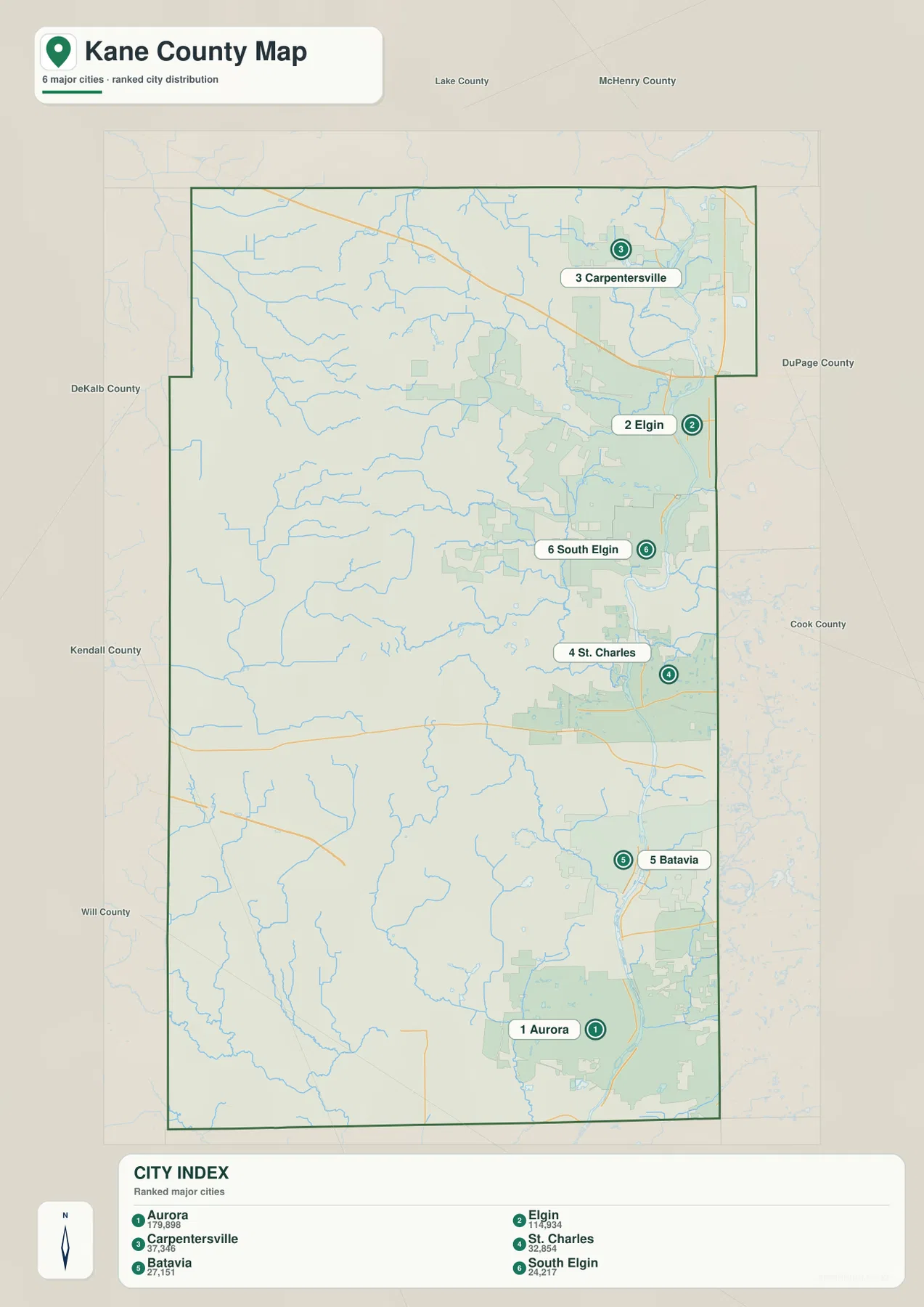
The city-distribution map removes most of the road clutter and makes one point especially clear: the six ranked cities are concentrated on the eastern side of Kane County. Aurora is shown at the south, Elgin at the northeast, and Carpentersville near the northern edge. South Elgin, St. Charles, and Batavia fill in the river corridor between them. There is no comparable string of large mapped cities across the western half, which helps explain why the county feels much more urban along the Fox River than near its western boundary.
The index printed on the map lists Aurora at 179,898, Elgin at 114,934, Carpentersville at 37,346, St. Charles at 32,854, Batavia at 27,151, and South Elgin at 24,217. Those figures are useful here as relative size cues rather than as a substitute for current official population statistics. Municipal boundaries can cross county lines, and population counts change with the source year. If you need a current figure for a city or the portion of a municipality inside Kane County, consult the U.S. Census Bureau or the relevant local government.
Aurora and Elgin work as opposite anchors for the map. Around Aurora, I-88, Route 25, Route 30, and several connecting roads form a dense transportation pattern. Around Elgin, I-90 and the northern east-west routes provide a similar organizing role. Between them, the county map adds communities that are not part of the six-city ranking, including Geneva and North Aurora. When both maps are used together, the result is a much fuller picture of a long urban corridor rather than six isolated dots.
Carpentersville sits near the northeastern projection of the county, while St. Charles and Batavia provide useful reference points farther south. South Elgin occupies the gap between Elgin and St. Charles. The surrounding county labels—McHenry, Lake, DuPage, Cook, Kendall, Will, and DeKalb—also show why Kane County interacts with several parts of the Chicago metropolitan fringe rather than facing only one neighboring region.
The city-distribution map should not be treated as a municipal boundary map. Its purpose is to compare where major named population centers are positioned. If you need to determine whether a specific parcel or street lies inside a city limit, use current local boundary data. For classroom, regional, or general reference use, the main takeaway is the strong eastern concentration of larger communities along and near the Fox River.
The Fox River and a network of creeks and small lakes
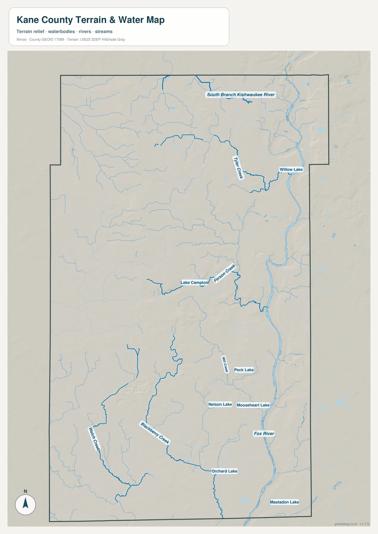
The Fox River dominates the water map as a long north-south feature near the eastern side of the county. Its position lines up closely with the same corridor that contains Elgin, St. Charles, Geneva, Batavia, and Aurora on the road map. Comparing the two maps is useful because it shows that the county’s major urban concentration is also a river-valley corridor. The map is designed to show the regional relationship among water features, not to provide navigation depth, flood-zone boundaries, or parcel-level shoreline information.
At the north, the South Branch Kishwaukee River appears near the county’s upper edge. Tyler Creek curves through the northeastern interior toward the Fox River, and Willow Lake is marked nearby. Numerous smaller blue lines branch across this part of the map. They reveal a more finely divided drainage landscape than the road map suggests, especially west of Elgin where the built environment becomes less continuous.
Near the middle of the county, Ferson Creek runs past the Lake Campton area toward the eastern river corridor. Mill Creek appears farther south, with Peck Lake nearby. Nelson Lake and Mooseheart Lake provide additional reference points between the Geneva-Batavia area and northern Aurora. These water features are small compared with the Fox River, but they help explain how the western and central parts of the county are broken into shallow valleys that lead toward lower ground on the east.
Blackberry Creek is one of the most noticeable waterways in the southern interior, and Welch Creek is labeled farther west. Orchard Lake appears to the east of Blackberry Creek, while Mastadon Lake is marked near the southeastern edge of the map. The result is a county where the Fox River provides the main trunk but many tributaries and small water bodies shape the interior. That distinction matters when reading the elevation map, because several of the lower corridors in the high western terrain line up with these creek valleys.
This water map is not a flood-risk, wetland-jurisdiction, engineering, or boating product. Stream width and water extent can change by season and scale. For current flood information, water quality, or legal shoreline questions, use the responsible agency’s current data. Here, the useful task is simpler: identify the Fox River, see which tributaries approach it, and understand how the county’s drainage network extends far into the western interior.
From 184 to 325 meters: the western rise above the river valley
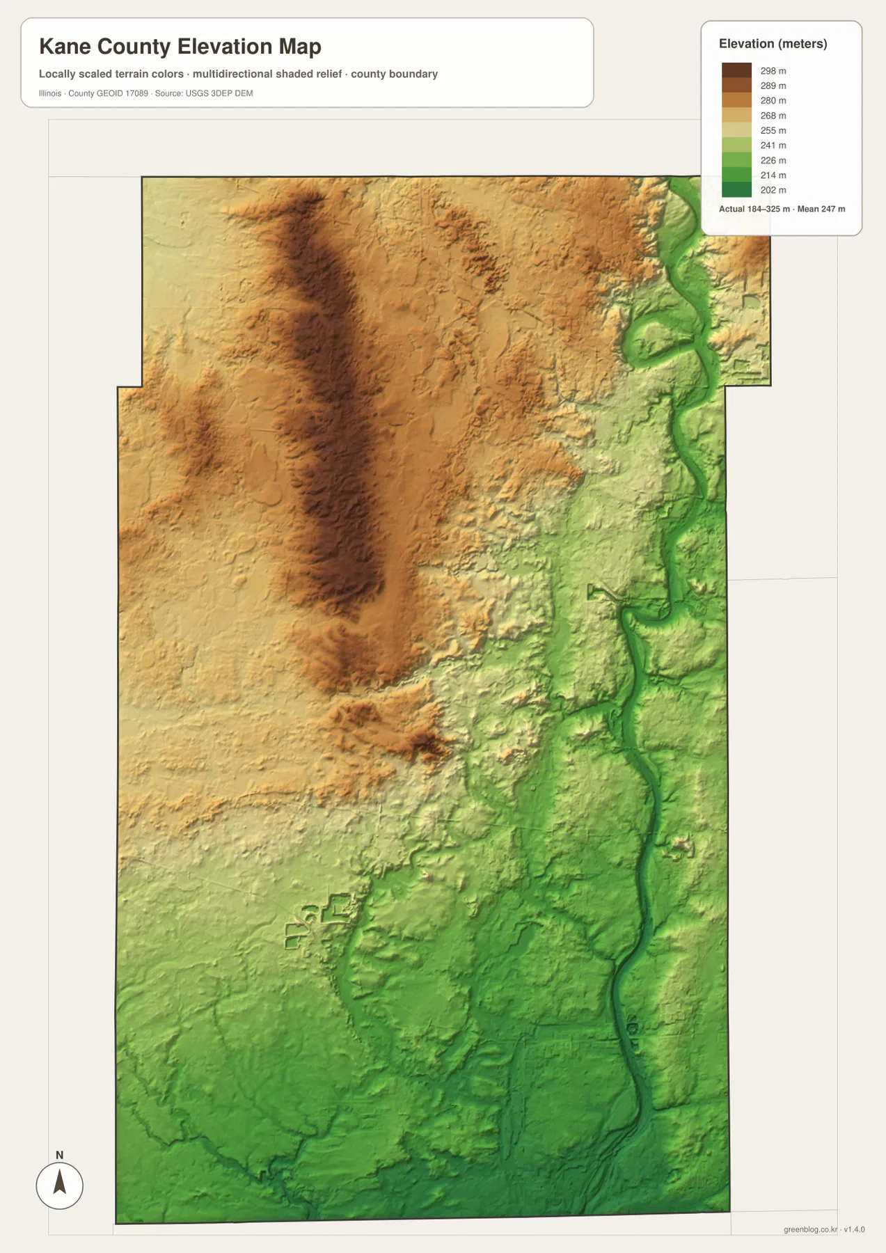
The elevation map gives the county a different visual structure from the road map. Its legend shows an actual elevation range of about 184 to 325 meters and a mean near 247 meters. Browns and tans cover much of the west and northwest, while greens form a long lower corridor beside the Fox River. That broad contrast matches the settlement pattern on the other maps: the major eastern cities occupy the river side of the county, while the western interior sits on generally higher ground.
The higher western area is not a single mountain or ridge. It is a broad upland surface cut by many shallow valleys, which is why the elevation colors vary across it rather than forming one uniform block. Locations such as Hampshire, Burlington, and Campton Hills are useful reference points when comparing the elevation map with the road map. Roads crossing from the west toward St. Charles, Geneva, Batavia, and Aurora gradually move from this higher interior toward the lower river corridor.
The Fox River valley stands out as a green band from north to south. If you mentally place Elgin, St. Charles, Geneva, Batavia, and Aurora on that band, the connection between relief and the urban corridor becomes easy to see. The river itself is not at one fixed elevation throughout the county, and the surrounding land is not perfectly flat. Still, at county scale the eastern valley is noticeably lower than the broad western upland.
Between those two zones lies a complicated transition. Tributaries such as Ferson Creek, Mill Creek, and Blackberry Creek cut lower paths back into the higher ground. On the elevation map, those valleys appear as green or yellow-green channels extending westward from the Fox River side. This is why a simple statement that “west is high and east is low” is only the beginning. The larger pattern is east-west, but the interior is repeatedly dissected by creek valleys and smaller ridges.
This generalized elevation surface is appropriate for comparing high and low areas across Kane County, not for survey-grade measurement. The 184-to-325-meter range should not be used to establish the exact elevation of a building, road project, drainage structure, or property corner. Engineering and legal work requires the original USGS elevation data or professional surveying. For ordinary map readers, the main value is seeing how the Fox River valley sits below the higher western interior.
Choosing the right map for roads, water, and relief
Start with the county map if you need an overall sense of direction. It is the clearest place to compare Elgin and Aurora, find Geneva in the middle of the Fox River corridor, and see how far places such as Hampshire, Burlington, Campton Hills, and Sugar Grove lie from the east side. I-90, I-88, Route 47, and the major east-west roads provide a framework that makes the other maps easier to read.
Use the city-distribution map when the question is about concentration rather than transportation. It shows immediately that the six ranked cities are on the eastern side, with Aurora and Elgin acting as the largest anchors. This is useful in a presentation or report where a full road network would distract from the settlement pattern. Remember, however, that the printed population figures are reference values on the supplied map and should not replace current Census data.
For river and drainage questions, open the terrain-and-water map and then compare it with the county map. Find the Fox River first, then trace Tyler Creek, Ferson Creek, Mill Creek, and Blackberry Creek back into the interior. The named lakes give extra landmarks where the road map has fewer obvious features. This combination makes it easier to explain why the county’s eastern cities occupy a river corridor while the western side is divided by smaller creek valleys.
Finish with the elevation map when you want to connect those features to landform. The higher western and northwestern ground, lower eastern river valley, and branching tributary corridors become clear at a glance. Instead of forcing every layer onto one crowded image, the four maps separate roads, city distribution, water, and elevation so each type of information remains readable.
The WebP images on the page are optimized for quick viewing. If you want to zoom into road numbers and creek labels, place a map in a slide, or print it at a larger size, the original JPGs are more convenient. The ZIP below contains four high-resolution JPG files: the county road-and-boundary map, major-city distribution map, terrain-and-water map, and elevation map. You can download the archive once and choose the map that fits your task. County boundary lines are for general reference and do not establish parcel ownership or legal property boundaries.
Frequently Asked Questions
Which map best shows the Fox River city corridor from Elgin to Aurora?
The county road-and-boundary map is the best starting point because it shows Elgin, South Elgin, St. Charles, Geneva, Batavia, North Aurora, and Aurora together with the main roads. If you only need to emphasize the concentration of larger communities, the city-distribution map is simpler. For a fuller explanation of why that corridor is distinctive, compare both with the water and elevation maps.
Can I use the population numbers on the city map as current official statistics?
They are better treated as reference values printed on the supplied map. City populations change over time, and municipal boundaries can cross county lines. If your project requires a current official population or the population specifically within Kane County, check the U.S. Census Bureau or the relevant city government rather than relying only on the map index.
Is the 184-to-325-meter elevation range accurate enough for surveying or drainage design?
No. That range is useful for comparing the county’s broad relief, especially the higher western interior and the lower Fox River valley. It is not a parcel survey or engineering surface. For exact site elevation, construction, or drainage calculations, use the original USGS data or a professional survey.
Map File Information
This ZIP contains the original high-resolution JPG versions of the Kane County road-and-boundary map, major-city distribution map, terrain-and-water map, and elevation map. Use the larger files to inspect the Fox River city corridor, western roads, tributaries and lakes, and the county’s east-west elevation contrast in more detail or for printing.
- Included Files: 4 high-resolution JPG images
- File Type: ZIP archive containing JPG images
Related Maps
Sources and references
These official and public sources are useful for checking Kane County government information and for finding more detailed boundary, hydrography, and elevation data. The maps on this page are designed for clear county-scale reference; use the original agency data when you need current administrative information or technical geographic detail.
- Kane County Government – official county government and administrative information in Geneva
- Forest Preserve District of Kane County – county natural areas and preserves, including sites along the Fox River
- U.S. Census Bureau TIGER/Line Shapefiles – county boundaries, roads, and geographic data
- USGS National Hydrography – authoritative river and stream data
- USGS 3D Elevation Program – source elevation data
Green Map creates custom-edited map images using open geographic data sources such as geoBoundaries, Natural Earth, OpenStreetMap, and government open data.
These maps are edited visual materials, not raw data files, and are provided for education, documents, presentations, and graphic reference.