Early County sits in the southwestern corner of Georgia, where Blakely serves as the county seat and the western side reaches the Chattahoochee River and the Alabama line. The map set on this page separates four subjects that are easier to understand when they are not crowded into one graphic: the county boundary and main roads, the relative positions of selected cities, named lakes and creeks, and local elevation. You can inspect the WebP previews in the article first and then download a ZIP with four high-resolution A3-size JPG maps for printing, classroom work, local research, presentations, or offline reference.
Blakely is the best starting point for reading the county. The general map places Arlington to the east, Damascus farther southeast within the broad eastern extension, Cedar Springs in the southwest, and Jakin near the narrow southern end. Routes 62 and 200 leave the Blakely area toward the east, while the corridor marked with 27 and 1 runs south through the county. The water and elevation maps then explain a different part of the same landscape: a low western river edge, a network of creeks and small lakes, and higher ground across much of the northwestern and north-central interior.
Table of Contents
Read the county boundary from Blakely and the numbered roads
The reference map draws Early County with a dark green outline and keeps selected roads, streams, places, and surrounding towns visible. Its shape is noticeably irregular. The western edge bends for a long distance, the eastern half extends outward in a broad rectangular section, and a narrow southern portion reaches toward Jakin. Blakely sits near the point where those larger pieces connect, which makes it a practical orientation point rather than simply another label. A small Georgia locator in the upper-right corner places the county close to the state’s southwestern corner.
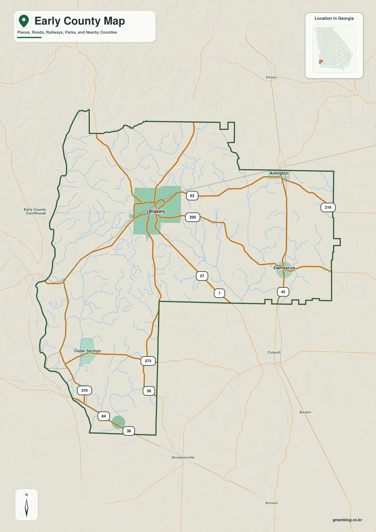
Several route numbers help organize the map. Route 62 runs east from Blakely toward Arlington, while 200 leaves the same area on a more southeasterly line. The north-south corridor marked 27 and 1 passes through the central part of the county and continues toward the south. Route 45 is shown through the Damascus area, 216 appears near the northeastern edge, and the southwest contains 273 and 370. Farther south, 39 is labeled above the lowest part of the county, and 84 and 38 appear close to the southern boundary. The map does not identify every local street, but these larger routes provide enough structure to compare where the communities sit.
The place labels show that Early County is not organized around one compact urban cluster. Arlington is near the top of the eastern extension, with Damascus farther south. Cedar Springs occupies the southwestern river side, while Jakin is near the county’s southern tip. Outside the boundary, names such as Edison, Colquitt, Donalsonville, and Boykin help establish direction beyond the county line. Those outside labels are especially useful when the county outline is unfamiliar because they show how the long southern section and the eastern extension fit into the wider southwest Georgia map.
The western boundary is tied to the Chattahoochee River corridor and the Alabama side of the regional setting, a relationship retained in the source page and visible when the boundary, water, and elevation views are compared. The western line is much more sinuous than the straighter sections in the east. That difference is useful for understanding how a natural feature can help define a county edge. The map is not a legal survey of the state line or river channel, however, so exact boundary questions should be checked against official boundary data rather than measured from this illustration.
Blakely, Damascus, and Jakin on the simplified city view
The city map strips away many of the smaller place labels and emphasizes three locations: Blakely as number 1, Damascus as number 2, and Jakin as number 3. The City Connections panel uses Blakely as the hub and displays direct-distance references of about 13 miles to Damascus and 20 miles to Jakin. That makes the map useful for comparing the county seat with the eastern and southern parts of the county without asking readers to sort through every local name. The numeric values attached to city names belong to the map’s source layer and should not be treated as a live population count; current demographics belong in the latest Census data.
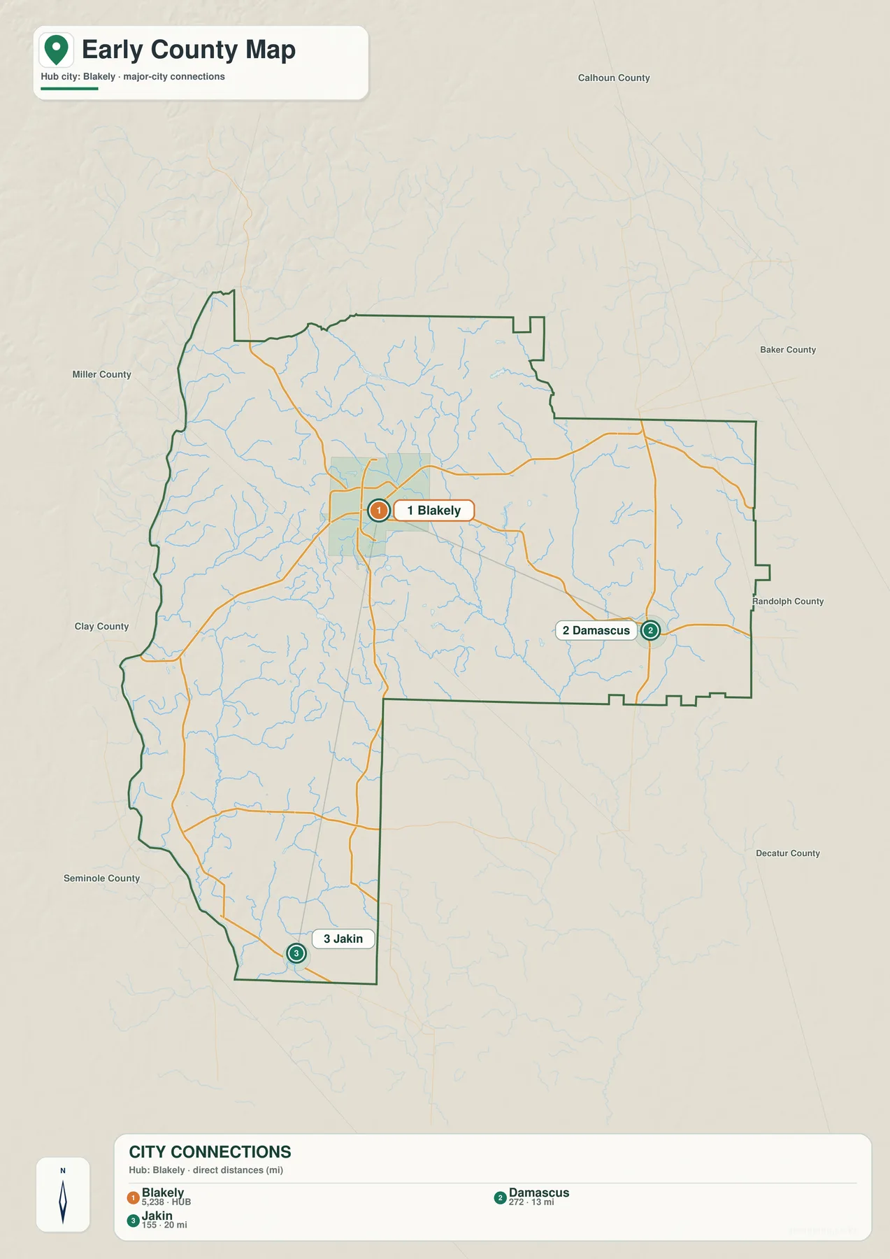
Blakely is slightly northwest of the county’s visual center, not halfway between every boundary. Damascus lies in the southern half of the eastern extension, and Jakin is close to the end of the narrow southern section. The three positions therefore describe the county’s shape as much as its settlement pattern. A trip from Blakely toward Damascus crosses the wide eastern portion, while the route toward Jakin follows the county south through a much narrower corridor. That contrast is easy to miss on a list of town names but immediately visible on the map.
Neighboring county names around the frame include Calhoun, Baker, Randolph, Decatur, Seminole, Clay, and Miller. They are background orientation labels rather than the subject of the map, yet they help explain which side of Early County is being viewed. The reference map also labels Arlington and Cedar Springs, even though those names are not part of the three-city ranking panel. The difference matters: the city view is a simplified selection, not a complete inventory of every municipality, unincorporated community, neighborhood, or service center.
Because Blakely is the county seat and the hub used in the city panel, it works well as the anchor for a classroom explanation or local overview. A reader can locate Blakely first, identify Damascus to the east and Jakin to the south, and then return to the road map to see which numbered corridors connect those directions. This is more informative than treating the city map as a population chart. Its main value is positional: it reduces visual clutter and makes the separation between the administrative center and the smaller outlying communities easy to see.
Lake Kolomoki and a dense network of creeks and small lakes
The water map changes the emphasis completely. Roads and city names recede, while named lakes, ponds, creeks, branches, and many thinner tributaries become the main content. Lake Kolomoki is labeled in the northern interior. Lake Louise and Lake Myrtle sit close together farther south, Jones Lake appears to the west, and Lake Clara is shown in the central-western area. On the eastern side, Sheffield Millpond and Big Pond are named within the broad rectangular extension. These labels show that the county’s water geography is not limited to one large river on the border.
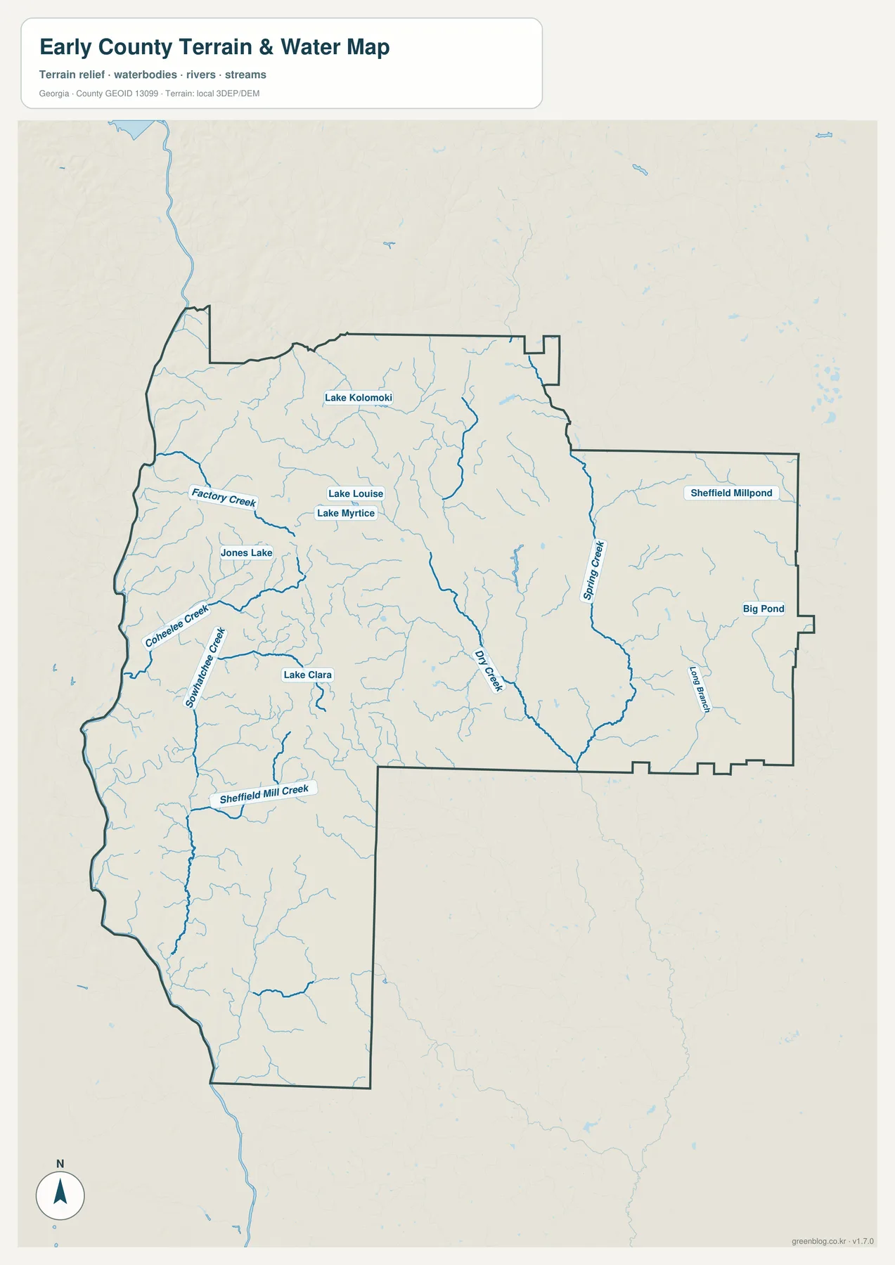
The western and central parts of the map carry many named streams. Factory Creek reaches toward the western side in the northwestern half. Coheelee Creek and Sowhatchee Creek run through the west-central area, and Sheffield Mill Creek crosses the southwest. Dry Creek is one of the longest named interior channels, descending through the center toward the southeast. Spring Creek forms a prominent blue line in the eastern extension, with smaller tributaries feeding it from both sides. Long Branch is labeled farther east, where the terrain is comparatively subdued but still cut by many drainage lines.
The Chattahoochee side becomes easier to understand when this water view is compared with the county outline. The source page identifies the river as an important part of Early County’s setting, and the western boundary follows the broad river corridor. Several western creeks run from the interior toward that lower edge. Coheelee Creek, Sowhatchee Creek, and Sheffield Mill Creek are good examples of small waterways that help connect the county’s higher interior to the river-side lowlands. The map does not provide streamflow, flood zones, water depth, or access rules, so it should be used for location rather than hazard or recreation decisions.
Lake Kolomoki also provides a link to the county’s historical context without requiring the map itself to carry a history lesson. The supplied source catalog includes a New Georgia Encyclopedia article about Kolomoki Mounds, and the water map places Lake Kolomoki in the northern part of the county. Readers interested in how that place name relates to the archaeological and historical site can use the source link below after locating the area on the map. This article stays with what the package supports: the lake’s mapped position and the existence of a vetted external reference for the broader Kolomoki context.
From 26 to 107 meters: higher northern ground and lower river-side terrain
The elevation map gives Early County an actual mapped range of about 26 to 107 meters, with a mean near 65 meters. Dark green represents the lower end of the local scale, lighter green and yellow mark intermediate terrain, and brown indicates the relatively higher ground. The strongest contrast is along the west, where low green terrain follows the Chattahoochee side, and the northwestern to north-central interior, where broad brown and orange areas rise above the river edge. The county is not mountainous, but the relief is strong enough to make valleys and uplands visible.
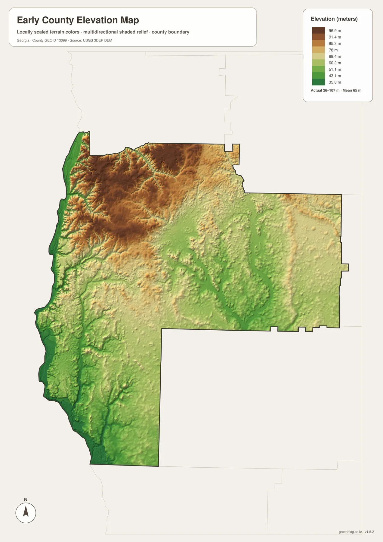
Across the northwest and north-central portion, the shaded surface contains broad higher areas cut by short green valleys. Moving east into the rectangular extension, the colors become more mixed and generally lighter, although narrow ridges and creek valleys remain visible. A long lower corridor follows Dry Creek through the central part of the county, and the Spring Creek area in the east is also associated with lower green terrain. The southern section contains more green than the high northern interior and connects visually with the low western side.
The relationship between terrain and water becomes particularly clear when the elevation and hydrography maps are placed side by side. Dry Creek and Spring Creek follow low corridors, while the western tributaries descend from higher interior ground toward the Chattahoochee side. The same pattern appears around smaller branches: the blue lines tend to occupy the green grooves between lighter or brown ridges. This is a useful physical-geography comparison, but it does not turn the illustration into a survey. Exact elevations, grades, drainage design, and construction decisions require the underlying USGS elevation data or a professional field survey.
The 65-meter mean is best read as a countywide summary, not the height of a typical house or road. Places along the western river-side lowlands are much closer to the lower end of the legend, while parts of the northwestern and north-central interior approach the higher colors. The southeastern and southern portions occupy more of the middle and lower bands. Describing Early County only as flat southwest Georgia would therefore miss what this map actually shows: modest but repeated relief, with a clear difference between the low river corridor, creek valleys, and higher interior surfaces.
A useful sequence for comparing roads, towns, water, and terrain
For a first pass, begin with the reference map and locate Blakely inside the irregular county boundary. Follow 62 and 200 toward the east and the 27/1 corridor toward the south, then note where Arlington, Damascus, Cedar Springs, and Jakin sit. Move next to the city map, where the Blakely–Damascus and Blakely–Jakin relationships are simplified into three large labels. Once those directions are familiar, the water map is much easier to read because Lake Kolomoki, Dry Creek, Spring Creek, and the western tributaries can be placed relative to the settlements rather than viewed as isolated names.
The elevation map works best at the end of that sequence. It shows why the western edge and creek corridors look different from the northern interior and helps connect the blue water network to lower valleys. In a classroom lesson, the reference and city maps can support administrative geography and transportation, while the water and elevation pair can support a physical-geography discussion. A presentation does not need all four views on the same slide; choosing the one or two maps that match the subject usually keeps labels and boundaries more legible.
The source page retains two useful pieces of local context: Early County was established in 1818, and Blakely is its county seat. It also points readers toward the Chattahoochee River setting and Kolomoki Mounds. Those facts can be combined with the modern map without turning this page into a general history article. Population change, archaeological interpretation, land ownership, or changing road conditions are separate questions and should be checked against current or specialized sources. The Census and New Georgia Encyclopedia links below provide a starting point for two of those follow-up topics.
The WebP images in the article are lighter previews designed for browser viewing. The downloadable archive contains four original JPG files at 2572 by 3638 pixels, a portrait layout prepared for high-resolution A3 use. The extra detail is helpful when a map needs to be printed, enlarged, inserted into a report, displayed in class, or stored for offline reference. Printing one subject per page is usually clearer than shrinking all four maps together, especially for the small creek labels and the elevation legend.
What these maps can show—and what requires another source
These are county-scale reference maps rather than legal, cadastral, navigation, or emergency products. The general map selects major roads and place names, so it does not contain every local street, address, parcel, school, public facility, or unincorporated community. The city layer is intentionally simplified around Blakely, Damascus, and Jakin, which is why a place such as Arlington or Cedar Springs can appear on the reference map without appearing in the three-city panel. For current routing, closures, addresses, or municipal services, use a current local or navigation source.
The water map locates named lakes and creeks but does not supply flood-risk zones, depth, water quality, streamflow, fishing regulations, or public-access information. The elevation layer is suitable for broad comparison across the 26–107 meter range, not for determining the exact grade or height of a property. When a project depends on a legally precise boundary, authoritative hydrography, or measured elevation, the Census TIGER/Line, USGS National Hydrography, and USGS 3D Elevation Program links below are better starting points than reading values from the rendered map.
Frequently Asked Questions
Where is the Early County seat on the maps?
Blakely is the county seat and the main orientation point on both the reference and city maps. Routes 62 and 200 extend east from the Blakely area, while the corridor marked 27 and 1 runs south. The city map also uses Blakely as the hub when comparing the positions of Damascus and Jakin.
Which named lakes and creeks can I find on the water map?
Named waters include Lake Kolomoki, Lake Louise, Lake Myrtle, Jones Lake, Lake Clara, Sheffield Millpond, and Big Pond. The map also labels Factory Creek, Coheelee Creek, Sowhatchee Creek, Sheffield Mill Creek, Dry Creek, Spring Creek, and Long Branch. These labels are for geographic reference and do not provide flood, depth, water-quality, or access information.
What does the 26–107 meter elevation range mean?
It is the actual elevation range represented by the county layer in the supplied map, with a mean near 65 meters. Lower green terrain is especially visible along the western river corridor and in several creek valleys, while higher brown terrain is concentrated across much of the northwest and north-central interior. Exact point elevations should come from source elevation data or a survey.
What is included in the downloadable map ZIP?
The archive contains four JPG originals: a county reference map, a city map, a water map, and an elevation map. Each file measures 2572 × 3638 pixels and is intended for higher-resolution A3 printing, enlargement, classroom use, presentations, and offline reference. The WebP images embedded in the article are lighter browser previews.
Map File Information
Early County high-resolution A3 map files
- Included Files: 4 high-resolution A3 JPG map files shown in this article
- File Type: JPG files in a ZIP archive
- Intended Use: Printing, education, presentations, and map-based projects
Related Maps
Sources and references
- U.S. Census Bureau QuickFacts for Early County
- New Georgia Encyclopedia article on Kolomoki Mounds
- U.S. Census Bureau TIGER/Line Shapefiles
- USGS National Hydrography
- USGS 3D Elevation Program
These links provide follow-up sources for current county statistics, the Kolomoki Mounds context, official boundary data, hydrography, and elevation. The article itself stays grounded in the supplied Early County map package: the visible road numbers and place labels, the named lakes and creeks, the county shape, and the 26–107 meter elevation range shown in the four previews.
Green Map creates custom-edited map images using open geographic data sources such as geoBoundaries, Natural Earth, OpenStreetMap, and government open data. These maps are edited visual materials, not raw data files, and are provided for education, documents, presentations, and graphic reference.