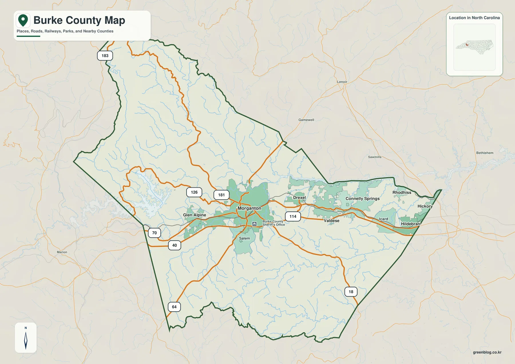
Burke County becomes much easier to understand when the map is read as a mountain county with a narrow, connected settlement corridor rather than as a single dot around Morganton. You can download the high-resolution JPG versions of the county reference map, city-distribution map, and terrain-and-water map directly from this page in one ZIP. The central part of the county carries I-40, US 70, Morganton, Valdese, Drexel, Connelly Springs, and Hildebran, while the northwest opens toward Lake James and a dense network of mountain streams. Farther south, ridges and tributaries return and break the landscape into smaller valleys, so the three previews make it easier to compare roads, towns, water, and relief without crowding everything into one image.
The county reference map is best for boundaries and routes, the city map simplifies the positions of six major settlements, and the terrain-and-water map shows why the outer parts of Burke County look and function differently from the I-40 corridor. High-resolution JPG versions of all three maps can be downloaded together from the file box below, making it possible to use a clean web preview for reading and a larger file for printing or presentation work.
Table of Contents
Morganton sits where the county’s routes converge
Morganton is useful as the first reference point because several important routes meet or pass close to it. I-40 crosses the south-central part of Burke County from west to east, while US 70 follows a similar general direction through the connected town corridor. NC 181 approaches from the north, NC 126 reaches toward the Lake James side, NC 64 runs into the southwest, and NC 18 leaves the central area toward the southeast. Seen together, these roads explain why Morganton works as more than the county seat on the map: it is also a practical hinge between the eastern town belt, the western lake country, and the mountain roads that lead north and south.
The road pattern also prevents the county from being reduced to Morganton alone. Glen Alpine lies just to the west, where the urban pattern begins to thin before the terrain rises toward Lake James. East of Morganton, Valdese and Drexel sit close to the same east-west movement corridor, followed by Connelly Springs and Hildebran nearer the Catawba County side. The result is a recognizable chain of settlements across the middle of a county whose northern and southern margins are much more rugged.
The I-40 corridor strings together Burke’s eastern towns
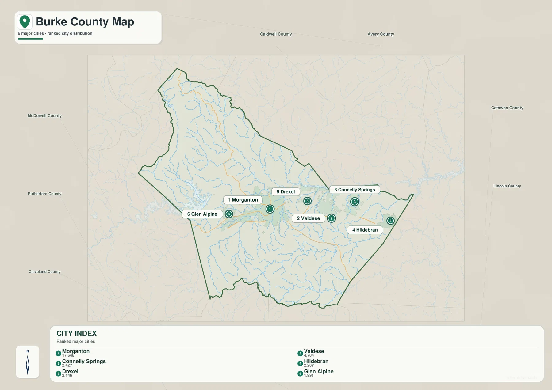
The city map strips away much of the road detail and makes the settlement pattern especially clear. Morganton is the largest of the six ranked places shown, but the other labels are not scattered evenly around it. Valdese, Drexel, Connelly Springs, and Hildebran all fall to the east, creating a sequence that points toward the Catawba County and Hickory side of the region. Glen Alpine is the only one of the six placed west of Morganton, so it provides a useful contrast to the more continuous eastern chain.
This arrangement matters when using the map for orientation. Someone looking only at county boundaries might assume that the interior is equally connected in every direction, yet the city distribution shows otherwise. The central and eastern settlements occupy a relatively narrow band, while large areas to the north and south contain few major town labels. Surrounding county names reinforce that directional pattern: McDowell County lies to the west, Caldwell and Avery are northward, Catawba is to the east, and Rutherford, Cleveland, and Lincoln frame parts of the southern side. The map therefore places Burke County between mountain country and the more connected settlement network extending eastward.
Lake James opens into a larger mountain-water network
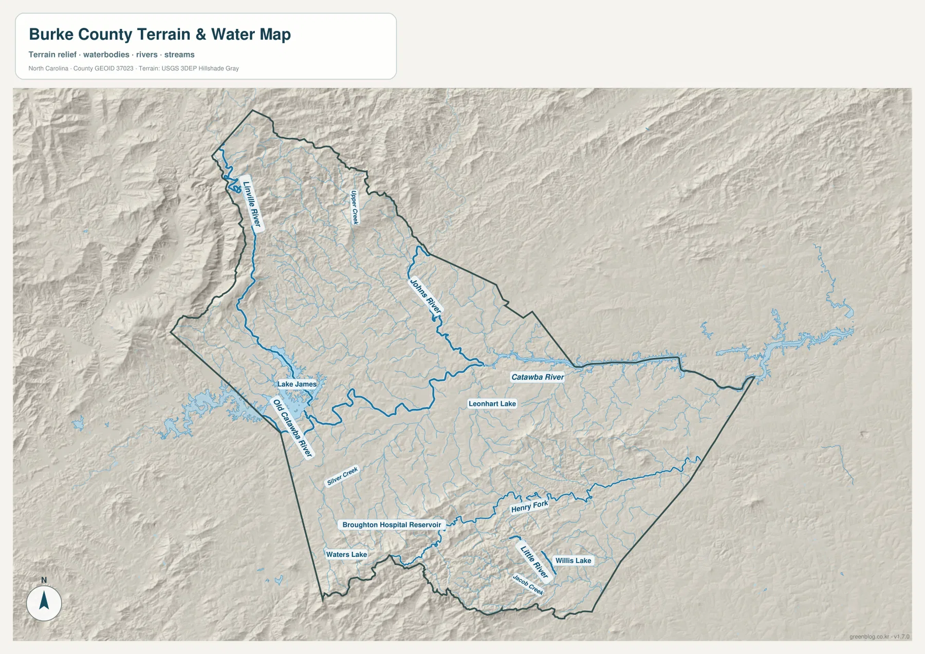
Lake James is the easiest large water feature to recognize on the terrain map, but it is only one part of the county’s drainage system. The lake sits along the western to northwestern side of Burke County, close to steep relief, and connects visually with waterways that descend from the mountains. Linville River enters from the northwest, while Upper Creek and Johns River occupy the northern interior. Eastward, the Catawba River forms the most prominent long river line across the county’s middle, providing a water reference that runs much closer to the town corridor than the rugged headwater streams.
South and southeast of Lake James, the map labels Old Catawba River and Silver Creek. Leonhart Lake appears nearer the center, and the southern half contains another group of waters including Henry Fork, Little River, Jacob Creek, Willis Lake, Waters Lake, and Broughton Hospital Reservoir. These features are useful because they show that Burke County is not divided into a simple “lake side” and “town side.” Instead, many smaller watersheds occupy the ridges and valleys around the central transportation corridor, and the direction of each stream follows local terrain rather than a neat countywide grid.
Relief changes sharply away from the central corridor
The shaded terrain makes the difference between Burke County’s center and its outer sections immediate. Northwest of the town belt, closely spaced ridges surround the Linville River, Upper Creek, and the Lake James basin. The shoreline itself is irregular because water reaches into narrow valleys between higher ground. That relief is much stronger than the terrain around Morganton and the communities east of it, where the map appears broader and less sharply folded. The contrast helps explain why the principal road and settlement corridor occupies a limited zone instead of spreading uniformly toward the northern county line.
The southern half is also mountainous enough to affect the county pattern. Henry Fork and Little River wind through a series of ridges, and the southern boundary follows a noticeably irregular edge rather than a simple straight line. This matters because a description focused only on Lake James and the northwest would miss a second rugged area on the opposite side of the county. Morganton and the I-40 corridor sit between these more complex landscapes, creating a geographic middle ground where through travel and larger settlements are easier to connect.
Roads, towns, and rivers form one county pattern
Using all three maps together turns separate symbols into a coherent picture. The general county map shows the route framework, the city map confirms where the larger settlements cluster, and the terrain map shows what lies immediately beyond that cluster. I-40 and US 70 align with the most continuous group of town labels, while the larger mountain watersheds and steeper relief occupy much of the space north and south. The maps do not prove a single cause for every settlement location, but they clearly show the geographic relationship between the easier central corridor and the more broken outer terrain.
Different questions are easier on different versions. To locate Lake James relative to Morganton, the terrain-and-water map gives the clearest physical reference, while the county map adds the roads needed to understand the direction of travel. To compare Valdese, Drexel, Connelly Springs, and Hildebran without being distracted by smaller route lines, the city map is cleaner. To see how close Hildebran is to the eastern county edge or how NC 181 approaches Morganton from the north, the full county reference map is the better choice. Switching between them keeps a single busy image from trying to do every job.
Choosing the map that fits the task
Use the county reference map when the main need is orientation: county limits, major routes, neighboring places, and the location of the principal towns can all be read together. The city map is better for a classroom slide, report, or quick comparison where the six ranked settlements need to stand out without a dense road background. The terrain-and-water version is the strongest choice for topics centered on Lake James, the Catawba River, mountain valleys, drainage, or the contrast between the flatter central corridor and the higher outer sections.
The web images are intentionally convenient previews. For printing or larger presentation work, the downloadable archive contains the matching high-resolution JPG files for the county map, city map, and terrain-and-water map. Keeping the three versions together also makes it easier to compare the same county from a transportation, settlement, and physical-geography perspective without searching for separate files. These are static reference maps, so detailed turn-by-turn navigation, parcel boundaries, or live road conditions should be checked with a source designed for those specific tasks.
Frequently Asked Questions
Which side of Burke County is Lake James on?
Lake James is shown on the western to northwestern side of the county, west of Morganton. The terrain map places it beside steep mountain relief and connects it visually with the Linville River and other headwater streams, making the lake a useful reference for the county’s rugged northwest.
Why do Valdese, Drexel, and Connelly Springs appear in the same east-west band?
The city map shows those communities east of Morganton in a relatively narrow corridor. When the county map is added, I-40 and US 70 can be seen running through or near the same general band, so the cluster reads as a connected central-to-eastern settlement pattern rather than as isolated town labels.
What files are included in the Burke County download?
The ZIP contains three high-resolution JPG files: a county boundary and roads map, a simplified major-city map, and a terrain-and-water map showing shaded relief, rivers, streams, lakes, and reservoirs. The web previews let you identify the version you need before using the larger files.
Map File Information
Download three high-resolution JPG maps of Burke County in one ZIP archive. The files match the county, city-distribution, and terrain-and-water previews shown on this page.
- Included Files: Use only the versions confirmed in the article and supplied images
- File Type: Use the confirmed download contents
- Intended Use: Printing, education, presentations, and map-based projects
Related Maps
Sources and References
Official county information and the boundary, hydrography, and elevation resources associated with this map workflow are available from the following sources.
- Burke County Government – About Burke County
- U.S. Census Bureau TIGER/Line Shapefiles
- USGS National Hydrography
- USGS 3D Elevation Program
Green Map creates custom-edited map images using open geographic data sources such as geoBoundaries, Natural Earth, OpenStreetMap, and government open data.
These maps are edited visual materials, not raw data files, and are provided for education, documents, presentations, and graphic reference.