Cabarrus County is easiest to understand when its northwest urban cluster and its more widely spaced eastern and southern communities are viewed together. Concord sits near the middle-west of the county, Kannapolis is just to the north, Harrisburg lies toward the southwest, Mount Pleasant is farther east, and Midland is near the southern side. The maps on this page show those places along with the county boundary, major roads, streams, lakes, and terrain. A ZIP containing the three A3 high-resolution JPG map files is also available for download on this page.
The general county map is best for seeing roads and named places in one view, while the city map strips away much of the extra detail so the relationship between the main communities is easier to compare. The water and terrain map adds another layer entirely: Rocky River, Irish Buffalo Creek, Cold Water Creek, Dutch Buffalo Creek, several smaller streams, and a group of lakes become the main reference points. Looking across the three versions makes it possible to connect settlement, transportation, and drainage without forcing all of that information into a single crowded image.
Table of Contents
Concord, Kannapolis, and the county’s spread of communities
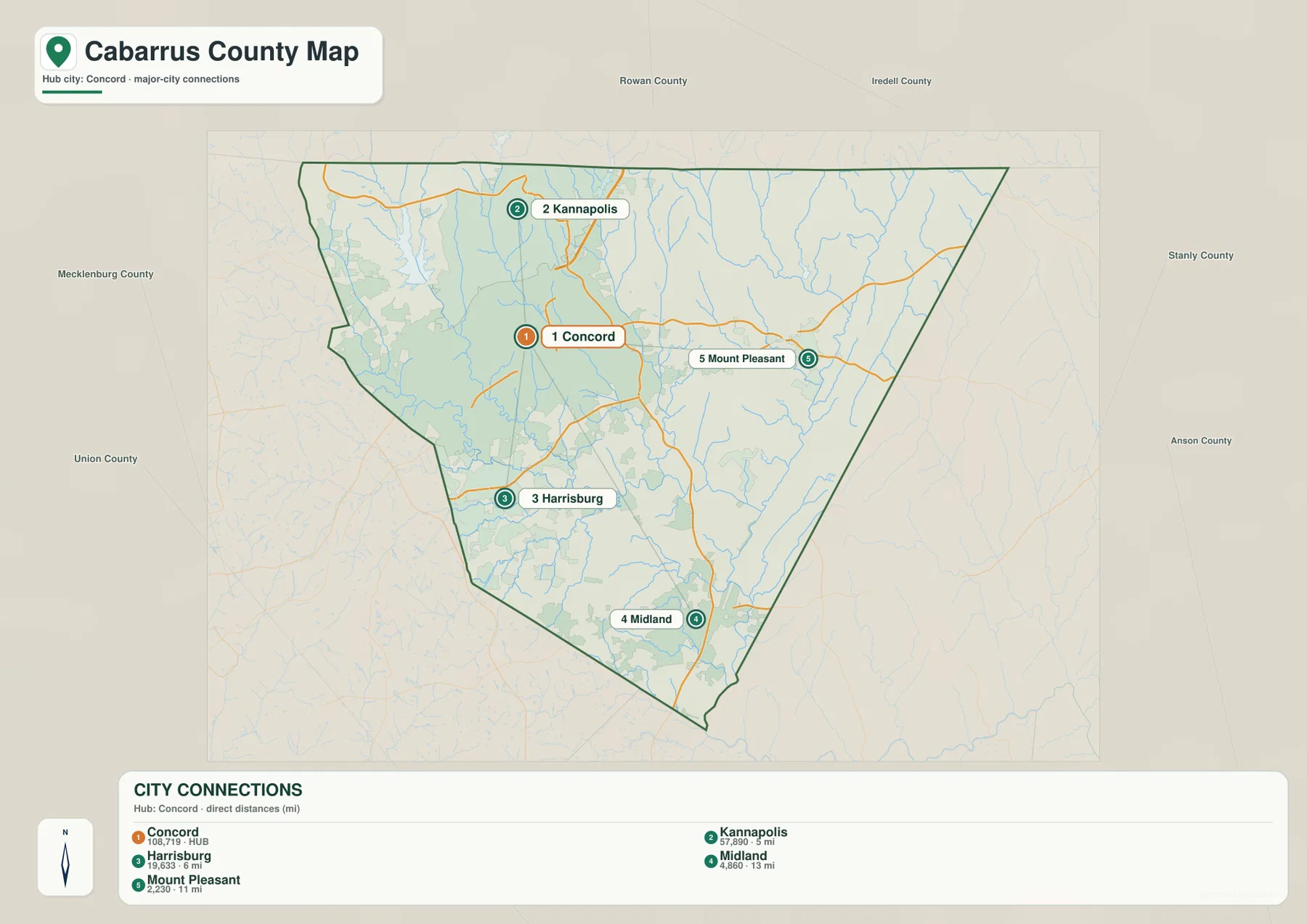
Concord is the strongest visual anchor on the city map. Kannapolis appears immediately to the north, making the northwest part of Cabarrus County look much more concentrated than the eastern or southern sections. Harrisburg is southwest of Concord near the Mecklenburg side of the county, while Mount Pleasant is well to the east. Midland sits near the southern edge. These five labels create a useful framework because they show that Cabarrus County is not arranged around one perfectly centered town; the main places are distributed unevenly across the county.
The city-connections panel gives direct-distance references from Concord. Kannapolis is shown at roughly 5 miles, Harrisburg at about 6 miles, Mount Pleasant at about 11 miles, and Midland at about 13 miles. Those numbers should not be read as driving distances or travel times. Their value is comparative: they make the close Concord–Kannapolis relationship obvious and show how much farther Mount Pleasant and Midland sit from the hub. For a quick county-wide orientation, that simple comparison is often easier to use than a denser road map.
Roads that connect the northwest cluster with the east and south
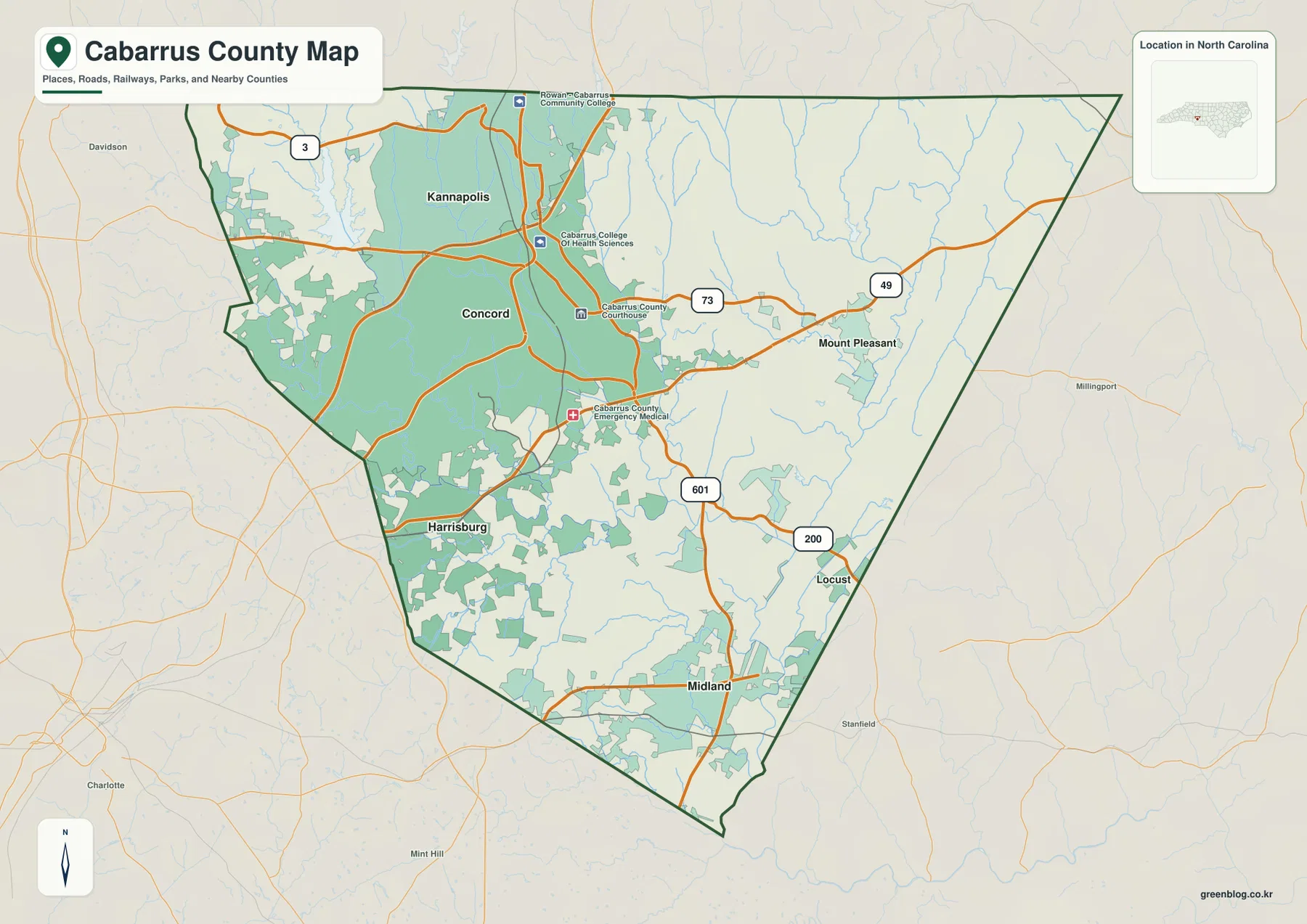
The general map adds the road network to that settlement pattern. NC 3 reaches the Kannapolis area in the northwest. Route 73 crosses the central part of the county and continues toward Mount Pleasant, while Route 49 is another important reference in the east. Route 601 runs through the central-southern section, and Route 200 provides a useful marker in the southeast. The map therefore shows a county where several labeled roads approach or pass near Concord before spreading toward communities that are farther apart.
This road pattern helps explain why the west and northwest appear busier on the map. Concord, Kannapolis, and Harrisburg are relatively close to one another, with more mapped development around them, while Mount Pleasant and the southeastern side have wider spaces between named places. The county boundary also gives context beyond Cabarrus itself: Rowan County is labeled to the north, Mecklenburg County and the Charlotte side are visible to the west, Stanly County is to the east, and Union County is shown toward the south. These surrounding labels are useful for orientation without requiring a separate regional map.
Rocky River and the creek network across Cabarrus County
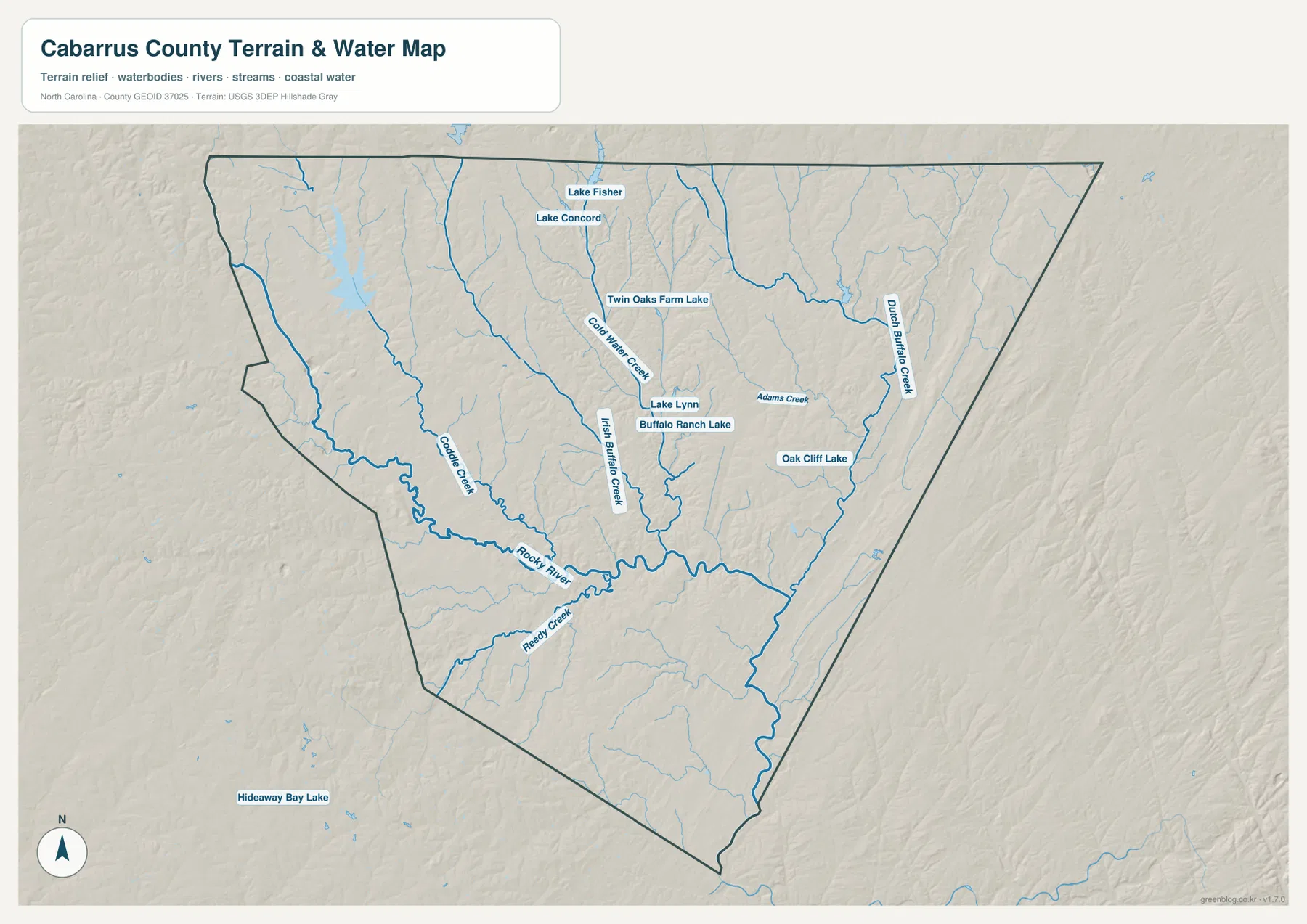
Water features change the way the county reads. Rocky River is the most prominent named river on the supplied water map, running across the southern half before continuing eastward. Several creeks feed into the broader drainage network. Coddle Creek is shown on the western side, Irish Buffalo Creek and Cold Water Creek pass through the central area, and Dutch Buffalo Creek is a major eastern reference. Adams Creek and Reedy Creek add smaller branches. Together they show that the county is crossed by many narrow valleys rather than one isolated river channel.
The map also identifies several lakes. Lake Fisher and Lake Concord appear in the north, Twin Oaks Farm Lake sits closer to the center, and Lake Lynn and Buffalo Ranch Lake are nearby. Oak Cliff Lake is farther east. These named water bodies differ in size and purpose, so the map should be used to locate them rather than to infer ownership, access, or recreational rules. What the map does show clearly is how many water references lie close to the same areas that look heavily settled on the road map.
Gentle relief, stream valleys, and what the terrain shading adds
The shaded-relief background does not show a county dominated by high mountains or a single dramatic ridge. Instead, the surface rises and falls gradually, with stream valleys cutting through the terrain. Rocky River and the larger creeks occupy the lower lines in that landscape. When the relief and water features are viewed together, the drainage network becomes easier to follow because the channels are connected to visible changes in elevation rather than appearing as blue lines floating on a flat background.
This is especially helpful around the more developed northwest. The road map naturally draws attention to Concord and Kannapolis, but the water map shows Lake Fisher, Lake Concord, Cold Water Creek, and other nearby water features in the same part of the county. East and southeast of the main urban cluster, fewer large place labels appear, while Dutch Buffalo Creek and the Rocky River system become more prominent. The contrast is not a strict urban-versus-rural dividing line; it is a difference in how settlement labels, roads, and drainage features are distributed across the same county.
Choosing the right Cabarrus County map for the task
Use the general county map when you need the broadest reference. It keeps the county boundary, major communities, labeled highways, nearby county names, and selected local landmarks together. It is the most useful version for answering questions such as whether Mount Pleasant is east or west of Concord, where Harrisburg sits in relation to the western boundary, or which labeled routes continue through the central and southern portions of Cabarrus County.
The city map is more effective when the goal is to compare the main communities without the distraction of every stream or landmark. Its direct-distance panel also gives a quick sense of scale around Concord. The water and terrain map is the better choice for Rocky River, the major creeks, lakes, and the shape of the shallow valleys. Switching among the maps is useful because the same location can look very different depending on what is emphasized. Concord is an urban hub on the city map, a road junction on the general map, and a place surrounded by multiple drainage features on the water map.
Using the maps for printing, reference, and local comparison
The web images are designed for convenient on-page viewing, but the downloadable files are larger A3 JPG versions. They can be useful when a full-page county reference is needed for a class handout, a presentation, a printed planning sheet, or a personal map collection. The three files are not duplicates: one emphasizes the full county reference, one simplifies the major community connections, and one concentrates on terrain and water. Choosing the version that matches the question keeps labels easier to read and avoids adding information that is not needed.
Frequently Asked Questions
How close are Concord and Kannapolis on the city map?
The city-connections panel places Kannapolis about 5 miles from Concord by direct-distance reference. That helps explain why the two cities form such a strong northwest cluster on the map, even though they remain separate named communities.
Which river is the main water reference on the supplied map?
Rocky River is the most prominent named river on the water map. Irish Buffalo Creek, Cold Water Creek, Dutch Buffalo Creek, Coddle Creek, and smaller streams connect to the broader drainage system and help show how water crosses different parts of the county.
What files are included in the Cabarrus County download?
The ZIP contains three A3 high-resolution JPG files: the general county reference map, the city-connections map, and the water-and-terrain map. They match the map types previewed on this page and are intended for larger viewing, printing, or offline use.
Sources and Reference Data
- Cabarrus County GIS, Maps, and Data
- U.S. Census Bureau TIGER/Line Shapefiles
- USGS National Hydrography
- USGS 3D Elevation Program
Map File Information
The download ZIP contains the three A3 high-resolution JPG maps shown on this page in larger original dimensions for printing and offline reference.
- Included Files: Use only the versions confirmed in the article and supplied images
- File Type: Use the confirmed download contents
- Intended Use: Printing, education, presentations, and map-based projects
Related Maps
Green Map creates custom-edited map images using open geographic data sources such as geoBoundaries, Natural Earth, OpenStreetMap, and government open data.
These maps are edited visual materials, not raw data files, and are provided for education, documents, presentations, and graphic reference.