You can download four high-resolution A3 JPG maps of Lampasas County in one ZIP directly from this page. The set includes a general county map, a city-connections map, a terrain-and-water map, and an elevation map. Together they show Lampasas, Lometa, Kempner, roads marked 281, 183, and 190, the Lampasas River and named creeks, plus an actual elevation range of about 244 to 512 meters.
Lampasas is the easiest reference point because it sits near the southern part of the county where several major roads meet. Route 281 runs north from the city, Route 183 heads toward Lometa in the west-northwest, and Route 190 extends toward Kempner on the eastern side. Once those three directions are clear, the water and elevation maps make it much easier to see how river valleys cut through the county’s higher western terrain.
Table of Contents
Lampasas sits where the county’s main road directions come together
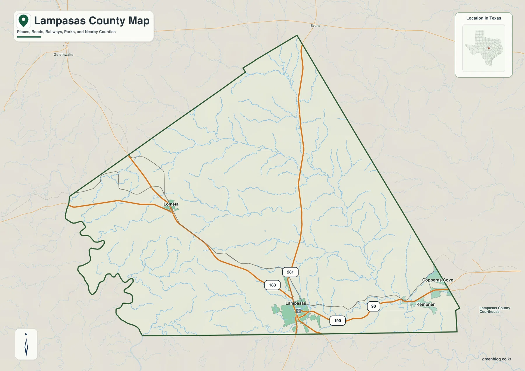
The general map places Lampasas close to the southern edge of the county. Route 281 runs north from the city through the middle of the map, making it the strongest north-south road reference. Route 183 approaches from the northwest and connects the Lampasas area with Lometa. Route 190 leaves Lampasas toward the east and continues toward Kempner near the eastern side.
Lometa is positioned in the western half of the county, while Kempner lies much closer to the eastern boundary. Using Lampasas as the center makes the contrast easy to see: Lometa is northwest of the hub, and Kempner is east. The northern part of the county contains fewer large settlement labels and more visible creek lines, so the map becomes less road-dense away from the southern communities.
The general map also includes many thin blue water lines, but they compete visually with roads and place names. It works best for locating towns and highway directions. When a stream name or drainage path is the main question, the terrain-and-water map later on the page provides a cleaner view of the same county boundary.
The city-connections map uses Lampasas as the hub
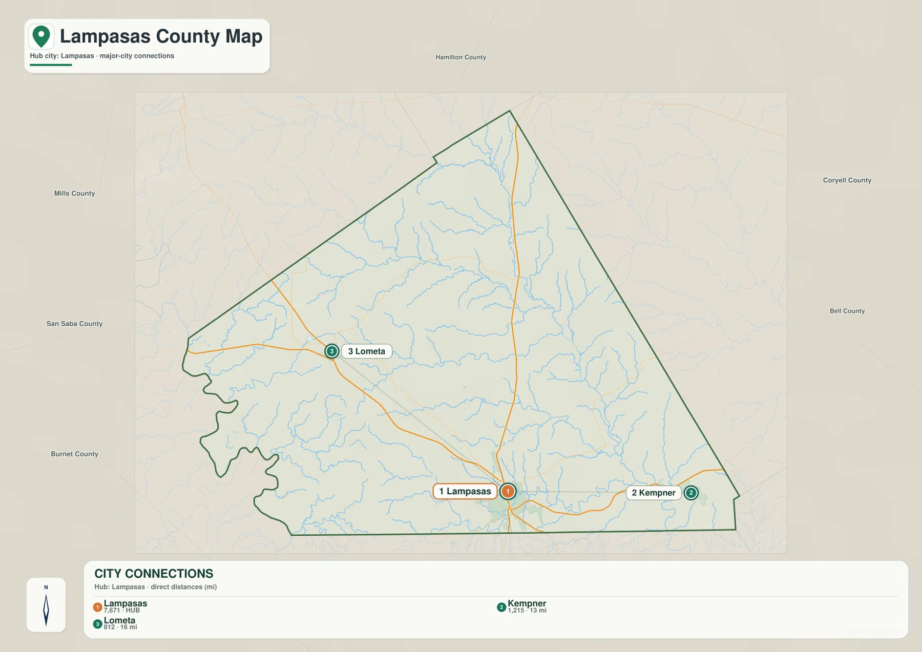
The city-connections view labels Lampasas as the hub and highlights Kempner and Lometa as the major connected places. The legend reports a direct distance of about 13 miles from Lampasas to Kempner and about 16 miles from Lampasas to Lometa. These values are straight-line distances shown by the map, not driving distances along the road network.
Kempner appears east of Lampasas, while Lometa sits to the northwest. That arrangement is clearer on this simplified map because most smaller road labels have been removed. The surrounding county names—Hamilton, Coryell, Bell, Burnet, San Saba, and Mills—also help place Lampasas County within its regional setting.
For a quick statement about relative location, this map is more efficient than the full county map. For actual travel direction, however, the general map should be used alongside it. The 13- and 16-mile figures should not be interpreted as road mileage, and the visible road corridors provide the better reference for how the places are connected on the ground.
Lampasas River and named creeks form a branching water network
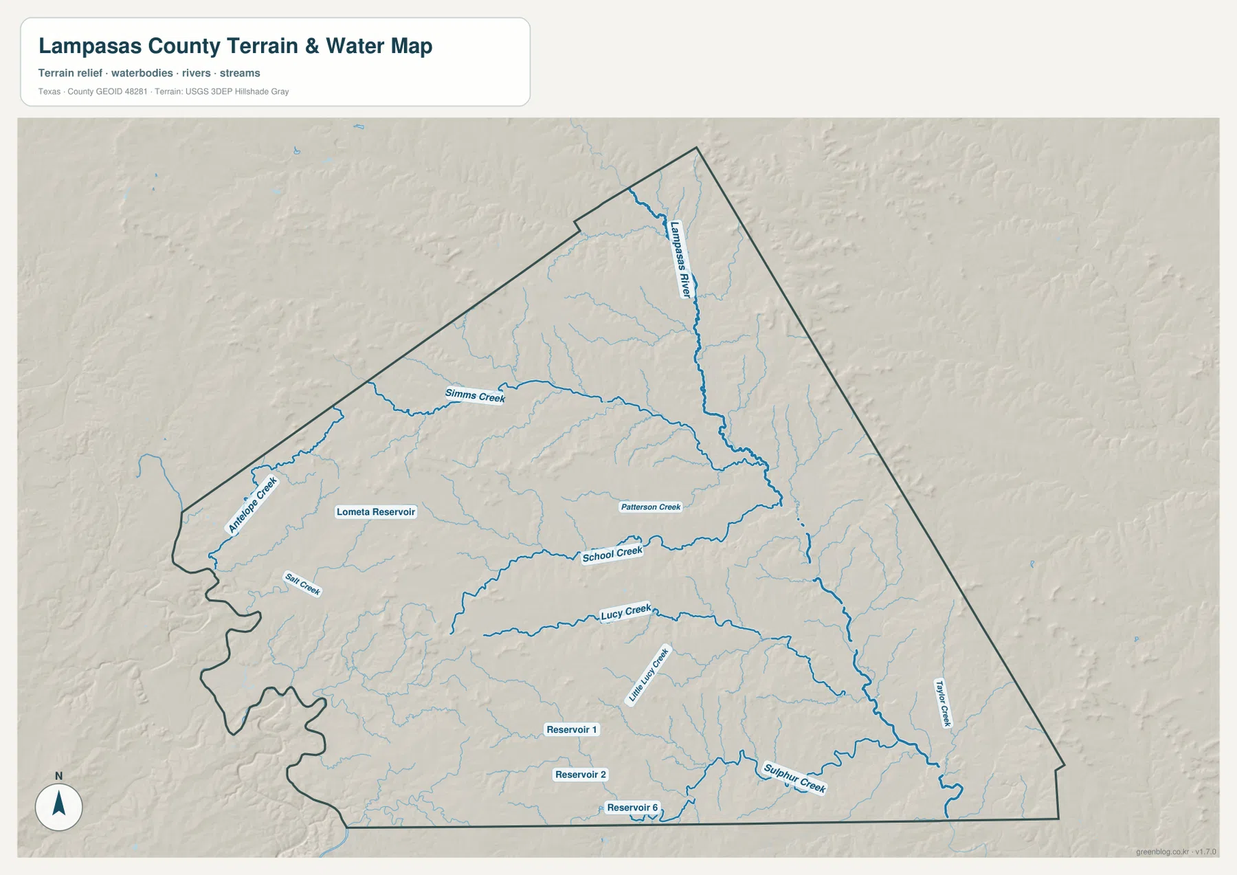
The terrain-and-water map makes the Lampasas River the strongest hydrologic feature. It enters from the north, runs through the central and eastern parts of the county, and continues toward the southeast. Simms Creek approaches from the west, while Antelope Creek is labeled in the northwestern portion. Many smaller tributaries join the larger channels, giving the county a dense branching pattern.
Patterson Creek and School Creek are labeled in the middle of the map. Farther south, Lucy Creek and Little Lucy Creek cross the interior, and Sulphur Creek is shown near the southeastern edge. Taylor Creek appears on the eastern side, while Salt Creek is labeled farther west. These names make it possible to use specific waterways as location references instead of treating every blue line as an unnamed stream.
Lometa Reservoir is marked in the western part of the county near the Lometa area. The southern portion of the water map also labels Reservoir 1, Reservoir 2, and Reservoir 6. The supplied image is useful for comparing the positions of streams and reservoirs, but it is not a flood-hazard, legal-boundary, parcel, or navigation map.
Higher western ground falls toward river valleys in the east
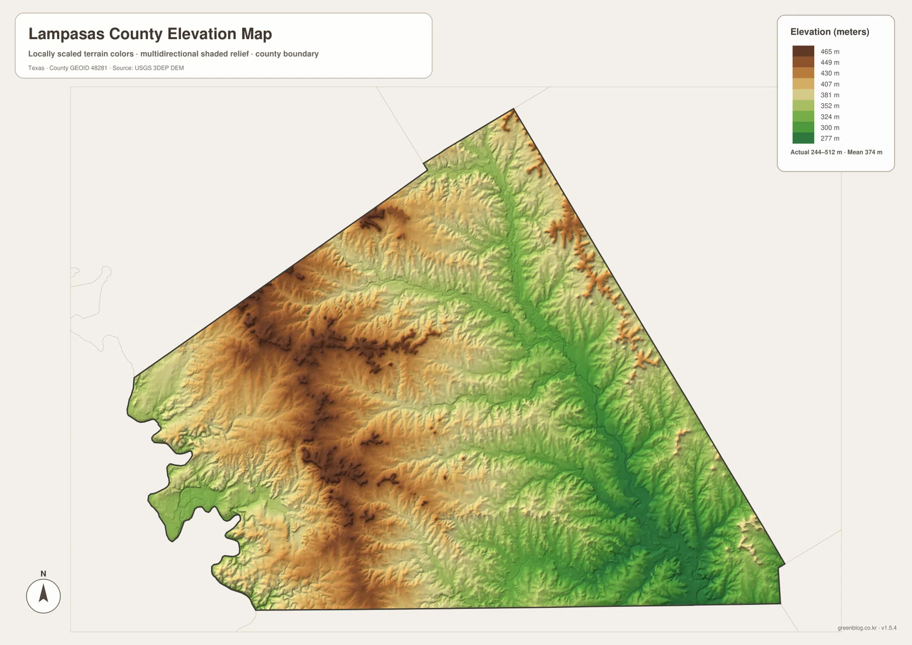
The elevation map reports an actual range of about 244 to 512 meters and a mean elevation of about 374 meters. Brown and tan colors dominate much of the west and northwest, where the higher ground is concentrated. Greens become more extensive toward the center, east, and southeast, especially along the lower valleys.
Comparing this view with the water map explains much of the pattern. The Lampasas River follows a broad lower corridor through the central-eastern portion of the county, and smaller tributaries occupy narrow green valleys branching into the surrounding hills. The western side is not a flat plateau; shaded relief shows repeated ridges and incised creek valleys.
The difference between the minimum and maximum displayed elevation is about 268 meters, enough to produce visible relief across the county. Even so, the map should be treated as a generalized regional elevation surface rather than survey-grade or engineering-grade measurement. Its main value is comparing relative height from one part of Lampasas County to another.
Matching the same place across road, water, and elevation views
A useful comparison begins with the road between Lampasas and Lometa. The general map shows Route 183 heading northwest, while the water map places Simms Creek and Lometa Reservoir in the same western part of the county. Moving to the elevation view then shows that much of this western area is higher than the broad lower terrain farther east.
The Lampasas-to-Kempner side tells a different story. Route 190 extends east from Lampasas toward Kempner, and the surrounding terrain becomes greener on the elevation map. The water view also contains more pronounced drainage corridors in the central and eastern portions. Looking at all three layers at the same orientation makes the relationship between roads, streams, and relief easier to understand.
The city-connections map is best used for relative position and straight-line distance. The general map is better for road direction, the water map for named streams and reservoirs, and the elevation map for comparing high and low ground. Since every image uses the same county outline, readers can switch between them without having to reorient the county shape.
Some of the smaller creek names and road numbers can be difficult to read in the web previews. The ZIP below contains the same four map views as high-resolution A3 JPG files, making them easier to enlarge or print for classroom, reference, or local-comparison use.
Frequently Asked Questions
What distances are shown from Lampasas to Kempner and Lometa?
The city-connections map lists about 13 miles from Lampasas to Kempner and about 16 miles from Lampasas to Lometa. Those are direct straight-line distances, not road-driving distances.
Which named waterways are easiest to identify?
The Lampasas River is the main reference. Simms Creek, Patterson Creek, School Creek, Lucy Creek, Sulphur Creek, and several other named creeks are also shown, along with Lometa Reservoir in the western part of the county.
What elevation range is shown for Lampasas County?
The supplied elevation map reports an actual range of about 244 to 512 meters and a mean of about 374 meters. The west and northwest are generally higher, while lower valleys are more extensive toward the central and eastern drainage network.
Sources and Reference Data
- U.S. Census Bureau TIGER/Line Shapefiles — official boundary and road geometry for geographic reference.
- USGS National Hydrography — official resources for rivers, creeks, reservoirs, and other water features.
- USGS 3D Elevation Program — official elevation resources used for terrain information.
- USGS The National Map Viewer — an official viewer for comparing multiple geographic layers.
Map File Information
Download four high-resolution A3 JPG maps of Lampasas County in one ZIP file.
- Included Files: county map, city-connections map, terrain and water map, elevation map
- File Type: JPG
Related Maps
- San Saba County Texas map
- Williamson County Texas map
- Travis County Texas map
- Robertson County Texas map
- Somervell County
Green Map creates custom-edited map images using open geographic data sources such as geoBoundaries, Natural Earth, OpenStreetMap, and government open data.
These maps are edited visual materials, not raw data files, and are provided for education, documents, presentations, and graphic reference.