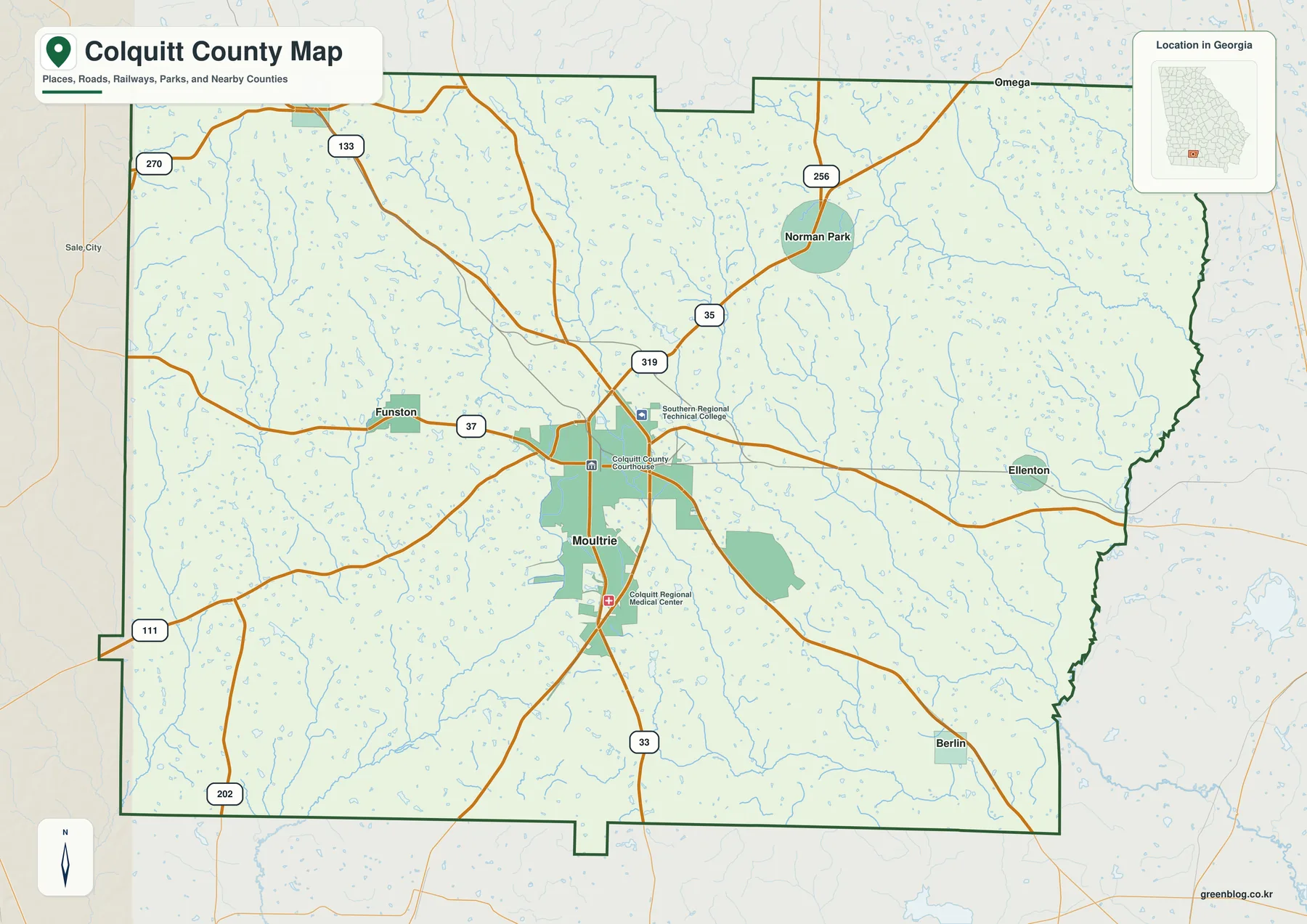
Download the Colquitt County Map package on this page as a ZIP containing four high-resolution A3 JPG files: county, city, water, and elevation maps. Colquitt County sits in southwest Georgia, where Moultrie functions as the clear county center and smaller towns are separated by broad stretches of farmland. The WEBP images below provide quick previews, while the ZIP keeps all four full-size map files together for printing and reference.
The maps are most useful when read together. Moultrie anchors the road network and local services, but Norman Park, Doerun, Funston, Berlin, and Ellenton show how settlement extends in several directions. Streams do not all drain toward one river, and the elevation image reveals a modest but visible contrast between higher rolling ground in the west and northwest and lower valleys toward the east and southeast.
The discussion below uses the supplied maps and the county-specific facts already verified in the source package. It is intended for orientation, education, printing, and general reference. Parcel boundaries, flood hazards, real-time road conditions, and survey-grade elevations require the appropriate official data rather than these generalized county maps.
Table of Contents
Start with Moultrie and the county road pattern
The general county map makes Moultrie the easiest starting point. The county courthouse, regional medical center, and a technical college are labeled close to the city, reinforcing its role as the administrative and service hub. Major routes spread away from this central area toward the smaller communities and the county line, so the map works well for understanding direction before looking at more specialized details.
The previously verified article identifies US 319 as the main north–south route through Moultrie, with Georgia 37 providing a strong east–west connection. Georgia 133 is another important regional route linking the Moultrie area with directions beyond the county. The map also shows numbered routes such as 35, 33, 111, 202, 256, and 270, which makes clear that rural access is not limited to a single highway corridor.
Around the county edge, Worth County lies to the northwest, Tift to the northeast, Cook to the east, Brooks to the southeast, Thomas to the southwest, and Mitchell to the west. Those neighboring counties help explain where the main roads continue after leaving Colquitt County. The line on this map is a county-scale boundary reference, not a property survey or a substitute for a detailed legal-boundary dataset.
Six communities show how settlement spreads across the county
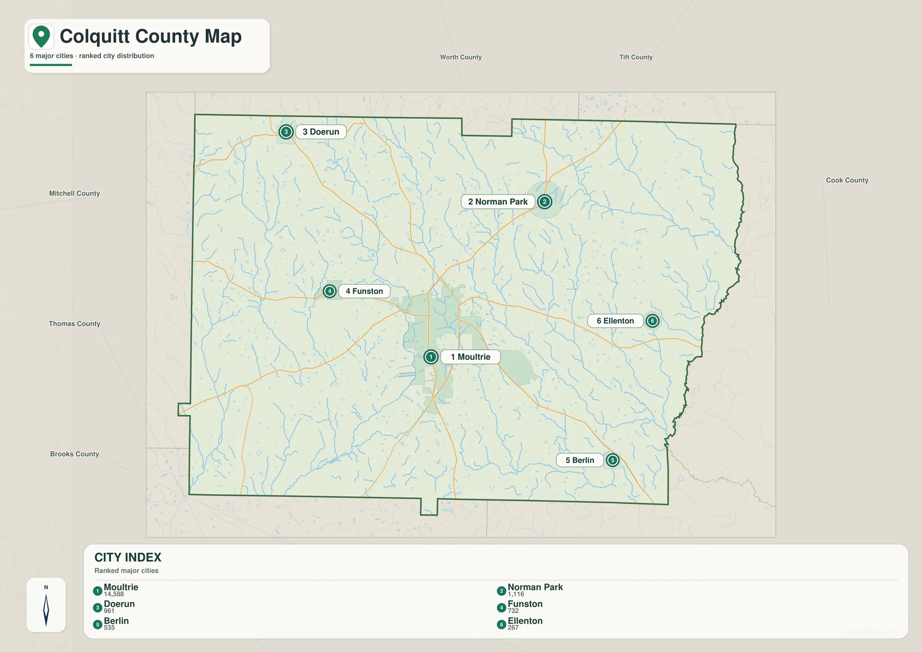
The city map ranks six incorporated places and gives each one a clear numbered marker. Moultrie is near the center of the county; Doerun is northwest, Norman Park northeast, Funston west, Ellenton east, and Berlin southeast. This arrangement is especially useful when a place name is familiar but its direction from Moultrie is not.
The index printed on the supplied map lists Moultrie at 14,588, Norman Park at 1,116, Doerun at 961, Funston at 732, Berlin at 535, and Ellenton at 267. The map itself does not state the year for those city figures, so they are best treated as the values used to rank the displayed communities rather than as a replacement for a current Census table. For the county as a whole, the existing source package cites a 2020 Census population of 45,898 and a July 1, 2025 Census Bureau estimate of 47,438.
The contrast between one larger center and several much smaller towns helps explain the open appearance of the county. Moultrie concentrates county government, shopping, health care, and other services, while farmland and rural residences fill much of the space between incorporated places. The city map therefore gives a better sense of settlement hierarchy than a road map alone.
Okapilco Creek is only one part of a divided drainage system
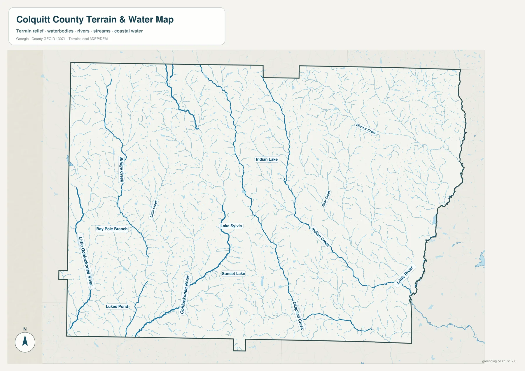
The water map adds a layer of detail that is easy to miss on the general county map. Okapilco Creek runs through the south-central part of the county, while the Ochlockonee River and Little Ochlockonee River appear in the west and southwest. The Little River marks a major drainage feature toward the eastern side, and smaller streams such as Indian Creek, Warrior Creek, Bridge Creek, and Little Creek branch through the interior.
These watercourses show why Colquitt County should not be described as belonging to a single river system. The verified material in the package explains that western areas drain toward the Ochlockonee system, much of the central and eastern county connects with Withlacoochee- and Little River-related subbasins of the Suwannee system, and a small northwestern area reaches the Flint drainage. County boundaries and watershed boundaries simply serve different purposes.
Okapilco Creek is particularly useful for connecting the map to an official monitoring record. USGS maintains a monitoring location for the creek in the county, and the older article notes several additional sites around Moultrie and farther downstream. Those records are the right place to look for measured water conditions; the map here is designed to show where streams and water bodies are located, not to provide flood forecasts or navigation information.
The supplied water map also labels smaller water bodies including Indian Lake, Lake Sylvia, Sunset Lake, and Lukes Pond. Seen together with the dense network of minor tributaries, they show that water is distributed through many small features rather than only a few large rivers. That matters in an agricultural county, where irrigation and water planning are part of the practical landscape even when a stream is not prominent on a basic road map.
A low county still has visible ridges and stream valleys
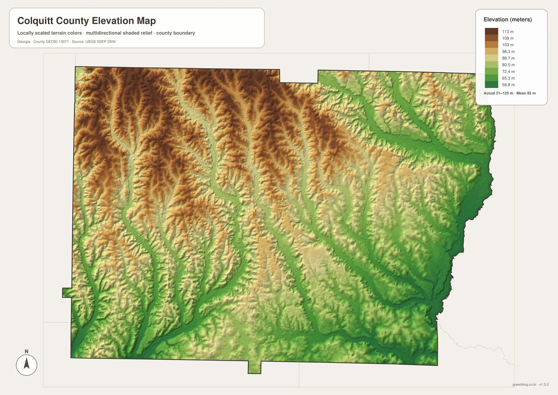
The elevation map reports an actual range of roughly 51 to 125 meters, with a mean near 85 meters. That is a modest range compared with mountain counties, but it is enough to create a recognizable pattern. Higher rolling ground is more common in the northwest and western interior, while lower terrain follows broad stream valleys toward the east, southeast, and parts of the southern edge.
The shaded relief makes the west look more deeply cut by narrow valleys, while the eastern side contains broader low corridors associated with the Little River and its tributaries. Moultrie sits between these stronger contrasts on moderately elevated ground. Comparing the elevation and water maps makes it easier to see why many stream lines follow the lower green corridors in the terrain image.
This surface is useful for comparing relative elevation across the county, but it is not a survey product. A landowner, engineer, or builder who needs an exact site elevation, grade, drainage calculation, or construction measurement should use the underlying elevation data and professional survey information. For a general map reader, however, the image explains the county’s rolling relief far better than a flat boundary map can.
Agriculture explains much of the open space between towns
The wide spaces between the six labeled communities are not empty areas. The source package cites the 2022 Census of Agriculture, which counted 429 farms and 184,400 acres of farmland in Colquitt County. Agricultural products sold for about $385.752 million, with crops accounting for 49 percent and livestock, poultry, and related products for 51 percent.
The same county profile lists 50,510 acres of cotton, 30,728 acres of peanuts, and 14,459 acres of vegetables, along with 50,821 acres of irrigated land. Those numbers help explain why the county’s water network and road system matter beyond simple geography: farm production depends on access to fields, markets, processing, and water resources spread well outside the incorporated towns.
Spence Field near Moultrie is another county-specific example. The existing verified material describes the Sunbelt Agricultural Exposition as having a roughly 100-acre exhibit area and a 530-acre working research farm used for irrigation, precision-agriculture, and crop demonstrations. It connects Moultrie’s central location with a larger agricultural economy that extends across the county and the surrounding region.
Choose the map that matches the question
For a first look, the county map is the quickest way to orient yourself because it combines roads, places, and the county outline. The city map is better when the question is about where the six incorporated communities sit relative to Moultrie or how their displayed population ranks compare. Water and elevation are more useful for natural features, especially when used side by side.
- County map: best for Moultrie, major road directions, the county boundary, and nearby counties.
- City map: best for comparing the position and displayed ranking of Moultrie, Norman Park, Doerun, Funston, Berlin, and Ellenton.
- Water map: best for Okapilco Creek, the Ochlockonee and Little River systems, tributaries, lakes, and ponds.
- Elevation map: best for comparing the higher rolling ground in the west and northwest with lower valleys toward the east and southeast.
For a classroom, report, or printed handout, start with the county map and add one of the thematic maps when the subject requires it. For parcel research, flood risk, engineering, exact routing, or current closures, use the appropriate official GIS, FEMA, survey, or transportation source in addition to these county-scale reference images.
Frequently Asked Questions
What is the main city in Colquitt County?
Moultrie is the county seat and the largest of the six communities ranked on the supplied city map. It is also the clearest road and service center on the general county map, so it works well as the reference point for locating Norman Park, Doerun, Funston, Berlin, and Ellenton.
Does all of Colquitt County drain to the same river?
No. The verified county material describes drainage toward the Ochlockonee system in the west, Suwannee-related subbasins including the Little River in much of the central and eastern county, and a small Flint drainage area in the northwest. The water map makes those different directions easier to understand.
Can the elevation map be used for surveying or construction?
No. The map is a generalized county-scale visualization with an actual displayed range of about 51 to 125 meters. It is useful for seeing relative highs, lows, ridges, and valleys, but exact site elevations and design measurements require the original elevation data and professional survey information.
Map File Information
Colquitt County map files
- Included Files: Map files described on this page
- File Type: ZIP archive
- Intended Use: Printing, education, presentations, and map-based projects
Related Maps
Sources and reference data
The county facts and explanatory context above come from the verified material supplied in the ZIP and from the following official or county-specific sources. For current demographic, agricultural, water, or elevation measurements, use the original agency pages rather than treating the map graphics as a live database.
- U.S. Census Bureau QuickFacts – Colquitt County
- USDA 2022 Census of Agriculture – Colquitt County profile
- USGS Okapilco Creek monitoring location
- USGS 3D Elevation Program
- Sunbelt Agricultural Exposition overview
Green Map creates custom-edited map images using open geographic data sources such as geoBoundaries, Natural Earth, OpenStreetMap, and government open data. These maps are edited visual materials, not raw data files, and are provided for education, documents, presentations, and graphic reference.