Coffee County is a broad South Georgia county organized around Douglas, with Nicholls to the east and Broxton and Ambrose to the north and northwest. The maps on this page separate that geography into four useful views: county boundaries and roads, city connections, waterways, and elevation. A download box near the top provides four high-resolution A3 JPG maps in one ZIP for printing, presentations, classroom use, and general regional reference.
Douglas is the best starting point because it sits near the center, slightly toward the southern half, and several major routes converge there. Yet the county is more than a hub-and-spoke road pattern. The water map shows drainage toward both the Ocmulgee and Satilla systems, while the elevation map places the county between about 34 and 103 meters above sea level. Reading those layers together makes the arrangement of farms, forests, towns, creeks, and low valleys much easier to understand.
Table of Contents
Douglas, the road network, and the county outline
The county map immediately shows why Douglas functions as the main reference point. US 441 runs north–south through the city, US 221 approaches the same central area, and Georgia 32 crosses east–west toward Nicholls. Georgia 268 helps connect the Broxton and Ambrose side, while other numbered routes such as 135, 206, 90, 64, and 158 spread into the outer parts of the county. The road pattern is not a dense urban grid; it is a set of long regional connections separated by large rural tracts.
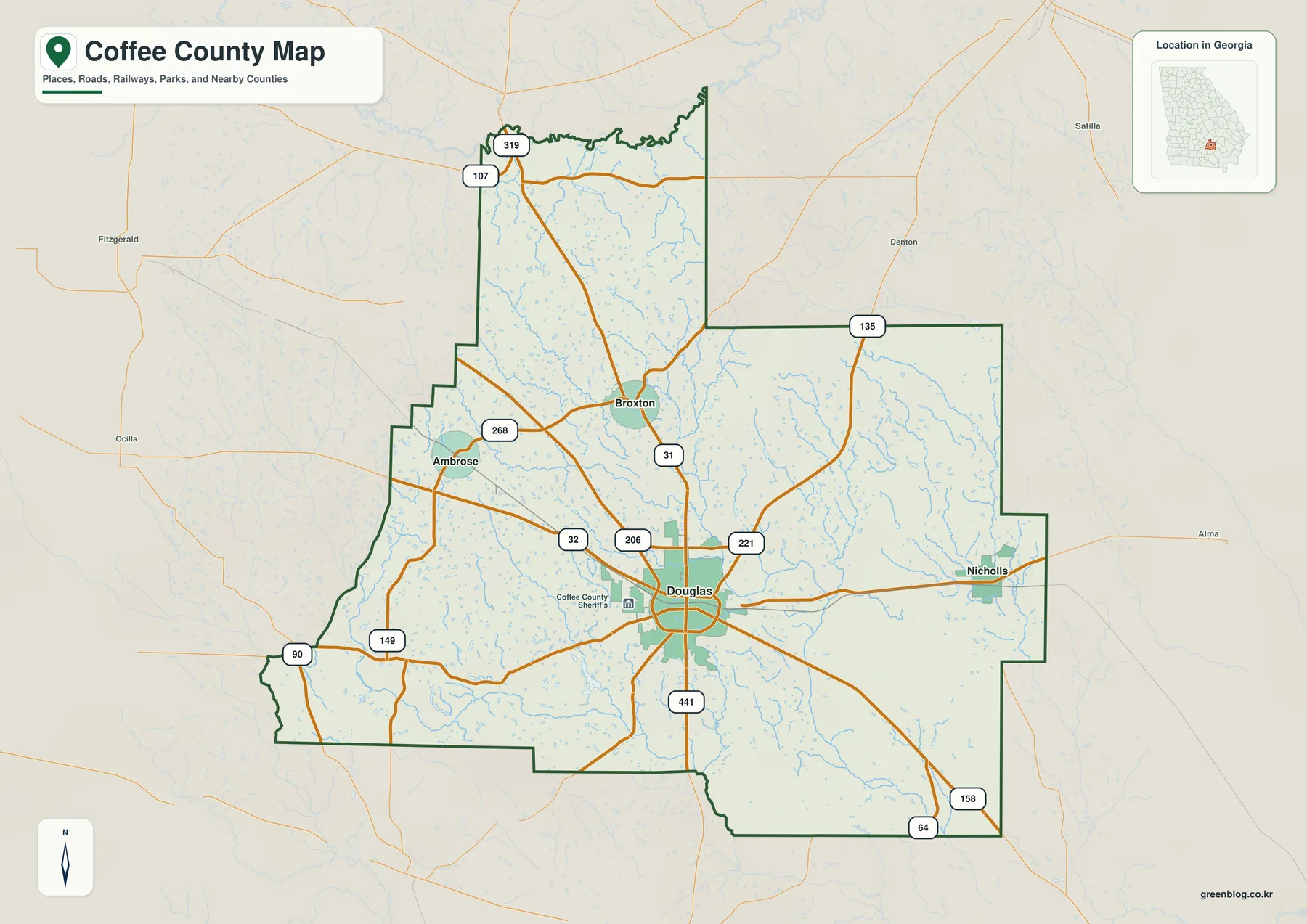
The outline also helps place Coffee County among a large set of neighbors. The verified material in the package lists Telfair, Jeff Davis, Bacon, Ware, Atkinson, Berrien, Irwin, and Ben Hill counties around it. With eight neighboring counties, Douglas works less like a suburb of one nearby metropolitan area and more like a service center for several rural corridors. That regional setting explains why the road network radiates in several directions instead of focusing on a single commuter route.
The map is suitable for orientation, not for legal boundary decisions. City symbols do not show municipal limits, and the county outline is not a parcel survey. A Douglas mailing address can lie outside the incorporated city, while school attendance areas, voting precincts, fire districts, utilities, and property lines all use separate boundaries. Use the map to locate the general area first, then check the current county, city, or state GIS when a specific jurisdiction matters.
Douglas also has a historical reason for appearing so dominant. The preserved local sources describe major growth after rail service arrived in the late nineteenth century, followed by a stronger role in the collection and distribution of agricultural products. That history still fits the modern map: the city remains the point where multiple roads meet, while the smaller incorporated places are spread across the northwestern and eastern parts of the county.
City connections from Douglas to Nicholls, Broxton, and Ambrose
The city-connections map reduces the road detail and focuses on relative position. Douglas is the hub. Broxton is shown about 8 miles to the north, Ambrose about 11 miles to the northwest, and Nicholls about 12 miles to the east. These are straight-line distances between city centers, not driving mileage, so a route planner may show a longer trip depending on the roads used.
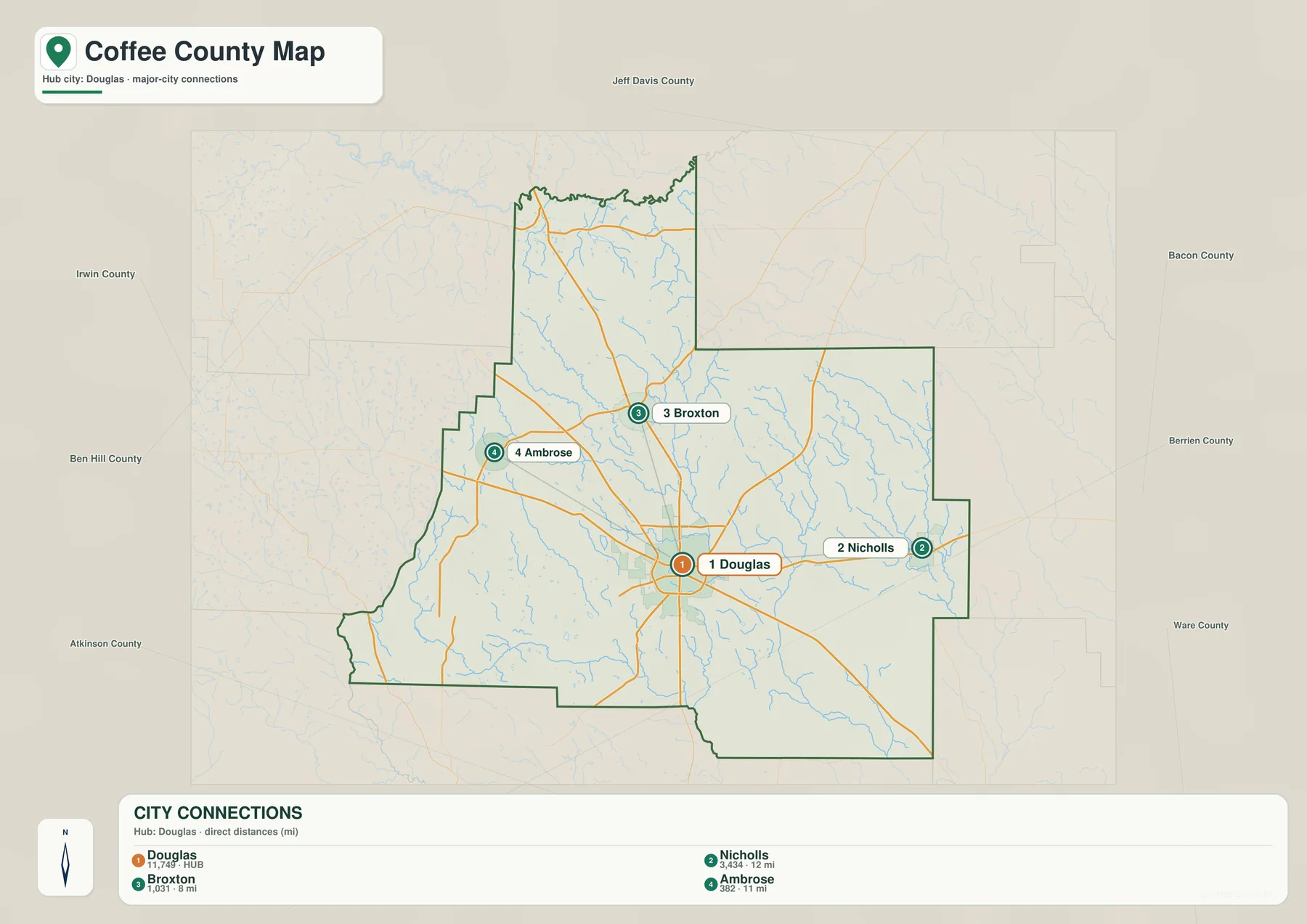
Broxton and Ambrose form a northwestern group, while Nicholls stands apart on the eastern side. When the city view is compared with the county map, that separation becomes more informative. Georgia 268 and northern routes serve the Broxton–Ambrose side, whereas Georgia 32 forms an important east–west connection toward Nicholls. Douglas sits between them, which is one reason it is a practical reference point for describing the county.
The four labels should not be treated as a complete inventory of every named community. Rural settlements, postal names, schools, parks, and small crossroads may not appear. Nor do the circular city symbols indicate legal municipal area. The purpose of the map is simpler: it lets a reader understand which direction each incorporated place lies from Douglas and how widely the settlements are spaced across a large rural county.
The panel on the map also reinforces Douglas as the largest hub among the four labeled places. That does not mean all county activity is concentrated inside the city limits, but it matches the existing description of Douglas as the administrative, education, health-service, and commercial center. For a classroom or presentation, the city map works well as a first illustration before adding road, land-use, or natural-resource detail.
Ocmulgee and Satilla drainage within one county
The water map reveals one of the most distinctive facts about Coffee County: water does not leave the county through a single river system. The Ocmulgee River is labeled along the northern side of the map, the Satilla River appears to the southwest, and the Seventeen Mile River runs through the southeastern part of the county. Between them is a dense network of smaller streams, including Twentymile Creek, Bear Creek, Indian Creek, Otter Creek, Hurricane Creek, and Hog Creek.
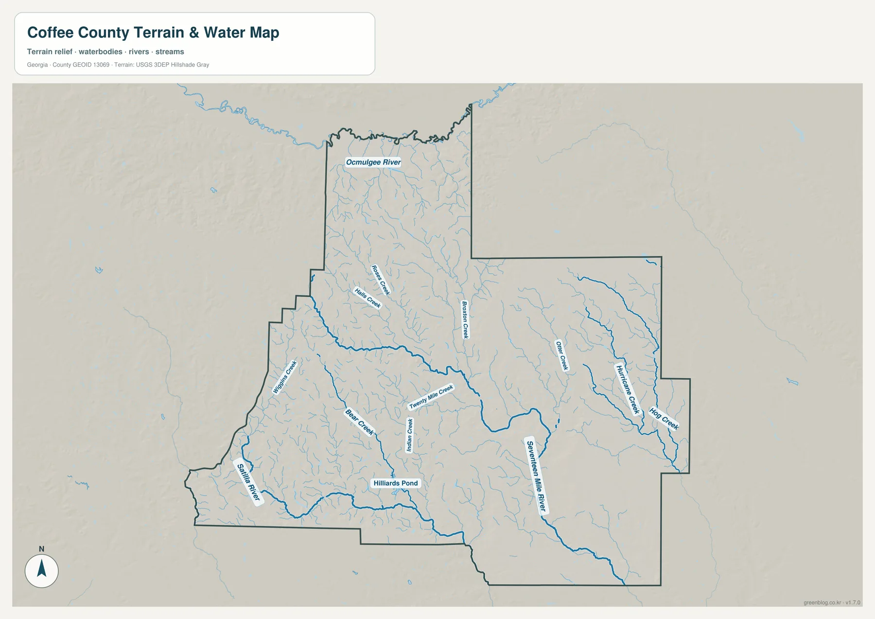
The existing verified article explains that streams around Douglas, including Twenty Mile Creek and the Seventeen Mile River, drain toward the Satilla system, while Rocky Creek near Broxton Rocks ultimately heads toward the Ocmulgee. In other words, a drainage divide crosses the county. Rain falling in different parts of Coffee County can follow entirely different river routes before reaching the Atlantic.
Smaller water features matter as well. Hilliards Pond is labeled in the south-central area, and numerous short tributaries branch through the farm-and-forest landscape. These channels often follow subtle low ground that is easy to overlook on a road map. The water layer is therefore useful for understanding general hydrology, but it is not a flood-risk map, wetland jurisdiction map, navigation chart, or water-depth product. Those questions require current specialized data from the responsible agency.
Two protected natural areas add useful local context. Near Nicholls, General Coffee State Park is described in the preserved sources as protecting cypress swamp, sandhills, and longleaf pine–wiregrass habitat around the Seventeen Mile River. East of Broxton, Broxton Rocks is associated with Rocky Creek and an unusual sandstone outcrop with cliffs, fissures, and a small waterfall. Those places show that the county’s natural landscape includes both wet blackwater bottoms and locally rugged rock features, not just flat agricultural land.
A 34–103 m elevation range across the Coastal Plain
The elevation map reports an actual county range of about 34 to 103 meters, with a mean near 70 meters. Coffee County is not mountainous, but the shaded relief makes small ridges and stream valleys visible. Higher brown and tan terrain is common across the west and central-west, while greener low ground extends through much of the east and southeast. A lower strip also appears near the northern edge where drainage approaches the Ocmulgee side.
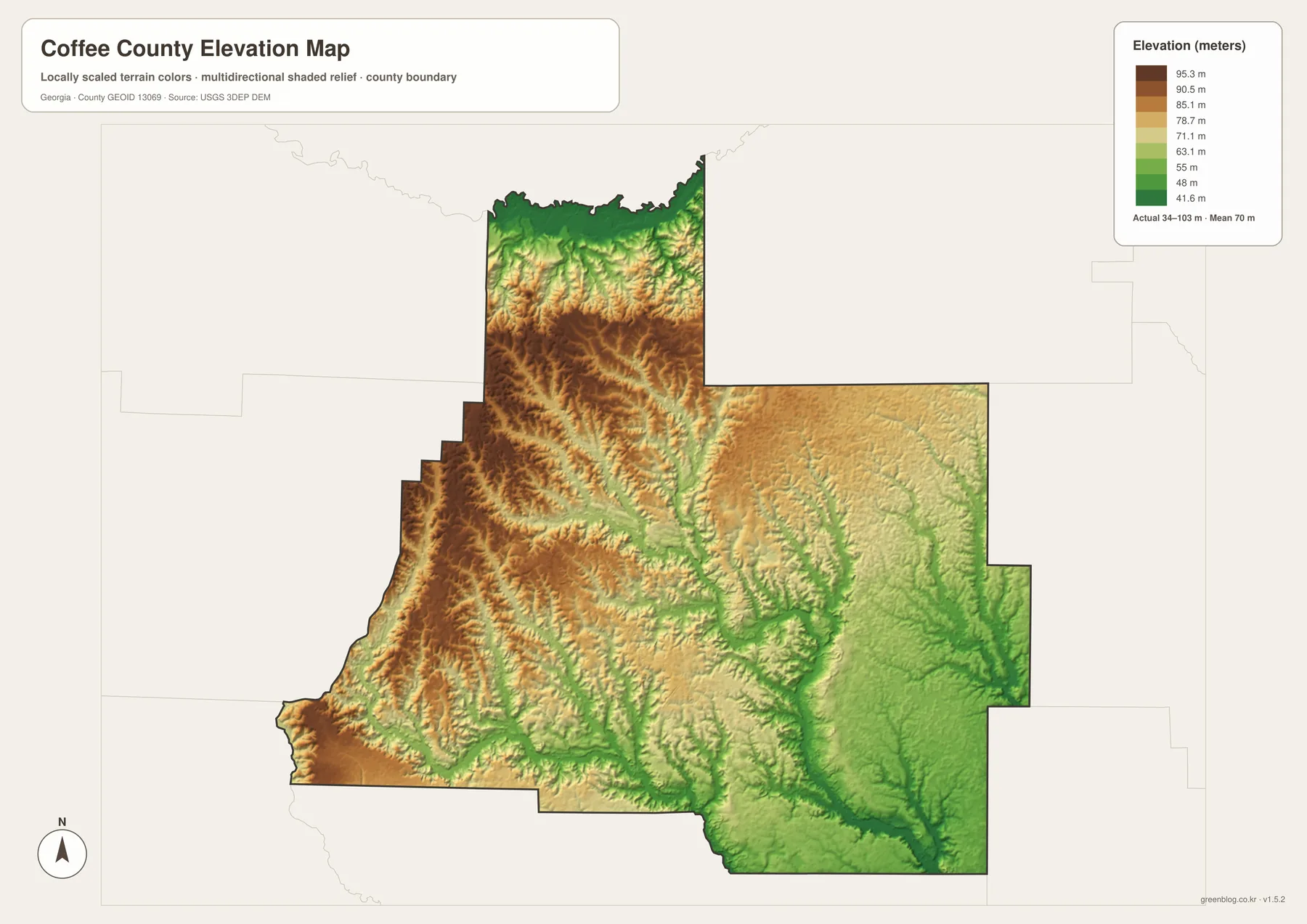
Comparing the elevation and water layers explains many of the curving stream paths. The Seventeen Mile River corridor is associated with lower green terrain in the southeast, and eastern creeks such as Hurricane and Hog follow low valleys cut between slightly higher surfaces. In the west and central part of the county, modest ridges divide tributaries and help separate drainage moving toward different river systems.
The total relief is modest compared with mountain counties, yet small differences matter on the Atlantic Coastal Plain. A few dozen meters of elevation can influence where water collects, where swampy bottoms occur, and how sandy uplands sit above nearby creeks. Broxton Rocks is a local exception where exposed sandstone and stream erosion create a much more dramatic landform than the countywide elevation range might suggest.
This map is a generalized county-scale surface. It is appropriate for comparing relative highs and lows, not for construction, drainage design, engineering, or parcel-level elevation. When an exact height is required, use the underlying USGS 3D Elevation Program data or a professional survey. The values printed on the map should be read as regional terrain context rather than survey-grade measurements.
Agriculture, forests, and the rise of Douglas
The broad spaces between the four incorporated places are a major part of Coffee County’s character. They are not empty land; they include row-crop fields, poultry operations, managed forest, rural housing, wetlands, and small communities. The preserved 2022 Census of Agriculture figures list 541 farms covering 161,594 acres and about $293.1 million in agricultural products sold. Livestock, poultry, and related products accounted for 65 percent of sales, while cotton and peanuts occupied substantial acreage.
Those numbers help explain the visual pattern on the county map. Roads stretch long distances between towns because the surrounding landscape is heavily rural. Douglas has the strongest concentration of services, but Nicholls, Broxton, and Ambrose provide smaller local centers for different parts of the county. Agriculture and forestry therefore remain useful context even though this particular four-map set does not include a dedicated land-cover layer.
Coffee County was created in 1854 from portions of neighboring counties, according to the existing historical material. Douglas became the county seat and grew much more rapidly after rail service arrived in the late nineteenth century. The City of Douglas source preserved in the package links the railroad, tobacco and agricultural markets, and later regional services to the city’s development. The modern road map still reflects that history in a different form: several routes converge at the same central place.
World War II aviation is another part of the local story. The preserved city source states that roughly 10,000 pilot cadets trained at the 63rd Army Air Forces Contract Pilot School in Douglas. The map set does not mark every surviving aviation site, museum, college, or historic building, so it should not be treated as a cultural-attractions map. It does, however, provide the geographic frame needed to place those subjects within the county.
How to compare the four maps for practical use
For a first look, start with the county map. Find Douglas, follow US 441 and US 221 north and south, and use Georgia 32 to orient the east–west direction. Then move to the city-connections map to see how Broxton, Ambrose, and Nicholls are spaced around the hub. That two-step approach separates road complexity from the simpler question of where the incorporated places lie.
Next, compare the water and elevation layers. East of Douglas toward Nicholls, the water map shows a denser network of named creeks and the Seventeen Mile River system, while the elevation map shows broader low green terrain in the same general direction. Northwest toward Broxton and Ambrose, the surface is often somewhat higher, and the northern drainage approaches the Ocmulgee side. Matching the same area across both maps is more informative than memorizing stream names in isolation.
A simple Douglas-to-Nicholls example shows the benefit. The county map first highlights the Georgia 32 corridor. The city map then places Nicholls roughly 12 straight-line miles east of Douglas. The water map adds Otter Creek, Hurricane Creek, Hog Creek, and the Seventeen Mile River system, and the elevation map shows that much of the eastern side is lower than the western uplands. Together, the layers describe both the human connection and the physical setting.
- Orientation: Use Douglas and the numbered highways to establish the county’s main directions.
- Settlement spacing: Compare the 8–12 mile straight-line city distances shown from Douglas.
- Water context: Follow the Ocmulgee, Satilla, Seventeen Mile, and named creek systems without treating the map as a flood product.
- Terrain context: Use the 34–103 m elevation surface to compare modest uplands with low stream corridors.
- Print use: Use the four A3 JPG originals in the ZIP when a larger image is needed.
For legal or operational decisions, use a more specialized source. Driving directions should come from a current navigation service or road agency, property and municipal limits from official GIS, flood risk from the applicable flood map, and precise elevation from USGS source data or a survey. The four maps are designed as clear regional references, and they work best when their scope and omissions are understood.
Frequently Asked Questions
Which cities are shown on the Coffee County city map?
The city-connections map shows Douglas as the hub with Nicholls, Broxton, and Ambrose around it. Broxton is labeled about 8 miles away, Ambrose about 11 miles, and Nicholls about 12 miles. Those are straight-line distances between city centers, not road mileage.
Do all Coffee County streams drain to the Satilla River?
No. The supplied water map and preserved source material show drainage toward more than one major river system. Much of the south and east connects with the Seventeen Mile and Satilla system, while part of the north drains toward the Ocmulgee. A watershed divide therefore crosses the county.
What elevation range is shown for Coffee County?
The elevation map reports an actual range of about 34 to 103 meters and a mean near 70 meters. Western and central-western areas are generally higher, while many eastern and southeastern stream corridors are lower. The surface is for county-scale comparison, not parcel surveying.
What is included in the Coffee County download ZIP?
The ZIP contains four original high-resolution A3 JPG files: the county map, city-connections map, water map, and elevation map. They are larger than the article’s WebP previews and are intended for printing, documents, presentations, and general geographic reference.
Map File Information
Coffee County Map Files
- Included Files: Four high-resolution A3 JPG maps: county map, city-connections map, water map, and elevation map
- File Type: High-resolution A3 JPG files in one ZIP archive
- Intended Use: Printing, education, presentations, and map-based projects
Related Maps
Sources and References
County-specific statistics and history follow the verified material preserved in the package, while the water and elevation discussion is tied to the supplied map previews and official reference links. For current legal boundaries or updated statistics, check the publication date of the source before using a value in a formal document.
- U.S. Census Bureau QuickFacts: Coffee County, Georgia
- USDA NASS: 2022 Census of Agriculture profile for Coffee County
- City of Douglas: county, railroad, and agricultural history
- Georgia Department of Natural Resources: General Coffee State Park
- The Nature Conservancy: Broxton Rocks and Rocky Creek
- USGS 3D Elevation Program
Green Map creates custom-edited map images using open geographic data sources such as geoBoundaries, Natural Earth, OpenStreetMap, and government open data. These maps are edited visual materials, not raw data files, and are provided for education, documents, presentations, and graphic reference.