The Clarke County Georgia Map set brings together four views of one of Georgia’s smallest and most urban counties: the county boundary and roads, the major city pattern, rivers and streams, and local elevation. Athens dominates the center of the county, Winterville sits near the eastern side, and the North and Middle Oconee river systems cut through a detailed Piedmont landscape. After reviewing the maps below, you can download a ZIP containing four high-resolution A3 JPG files for printing, reference work, classroom use, or insertion into documents.
The maps are most useful when read together rather than as four versions of the same picture. The general county map provides orientation and important roads and landmarks. The city map reduces the view to the principal incorporated places. The water map gives the river network much more emphasis, while the elevation map reveals ridges and creek valleys that are easy to miss beneath the urban road pattern.
Table of Contents
Clarke County at a Glance
Clarke County lies in northeastern Georgia’s Piedmont. Jackson County is to the northwest, Madison County to the northeast, Oglethorpe County to the east, and Oconee County along much of the south and west. The existing county material places Athens roughly 70 miles northeast of Atlanta. At statewide scale, the simplest way to locate Clarke County is to find Athens and then look for the unusually compact county boundary surrounding the city.
| State | Georgia |
|---|---|
| County and FIPS | Clarke County · 13059 |
| County seat | Athens |
| Established | 1801 |
| 2020 Census population | 128,671 |
| July 1, 2025 population estimate | 129,921 |
| 2020 land area | 119.22 square miles |
| Principal waters | North Oconee River, Middle Oconee River, Sandy Creek |
| Download | ZIP with four high-resolution A3 JPG maps |
The Census Bureau reported 1,079.2 residents per square mile in 2020. That density is easy to understand on the maps: Athens fills much of the county, and the distance from the urban center to a county line is short in several directions. Winterville remains a separate incorporated city to the east, while Bogart straddles the western county line and serves as a useful edge reference even though only part of it lies inside Clarke County.
County Map: Athens, Roads, and Nearby Places
The general county map is the best starting point for orientation. Athens-Clarke County occupies the central part of the frame, with Winterville on the east and Bogart near the west edge. Nearby labels such as Hull, Watkinsville, and Arnoldsville establish direction beyond the county line. Because Clarke County is compact, these surrounding places appear close to the boundary and make the county’s position within northeastern Georgia easier to understand.
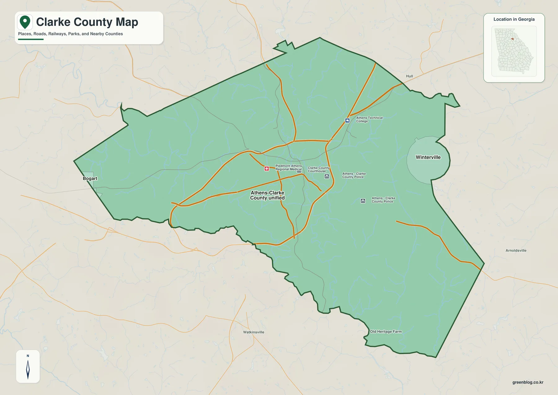
Athens is also the point where several important road corridors come together. The existing county material identifies SR 10 Loop, commonly known as the Athens Perimeter, as the ring around the central city and University of Georgia area. US 29 approaches from the north, US 78 provides an east-west route, US 441 runs generally north-south, and SR 316 connects the western side of Athens toward metropolitan Atlanta. On the preview, the larger roads converge around central Athens before branching toward the county edges.
The map also labels practical landmarks around the urban core, including Piedmont Athens Regional Medical Center, the Clarke County Courthouse, Athens-Clarke County Police, and Athens Technical College. These are not substitutes for a street-level navigation map, but they show how governmental, educational, and medical functions are concentrated around Athens. That concentration helps explain why a small county boundary can contain such a busy road network.
City Map: Athens-Clarke County and Winterville
The city map reduces the page to the principal urban labels and surrounding county context. Athens-Clarke County Unified Government (balance) is the dominant entry, while Winterville appears as a separate city on the eastern side. The map also names Jackson, Madison, Oglethorpe, Oconee, Barrow, and Walton counties around the frame, making it clear how quickly the Clarke County boundary gives way to neighboring jurisdictions.
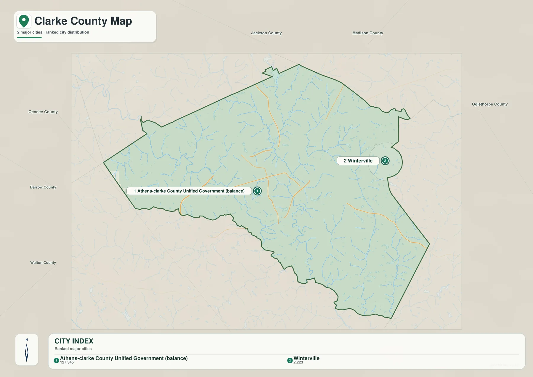
The relationship between Athens and Clarke County needs a little explanation. The former City of Athens and Clarke County governments unified in 1991, which is why the name Athens-Clarke County appears so often in local government material. The boundaries are still not interchangeable in every context: Winterville remains separately incorporated, and Bogart crosses the western county line with only part of the municipality in Clarke County. The city map is useful because it simplifies that unusual arrangement without suggesting that every label represents the same kind of boundary.
The University of Georgia is another reason Athens carries so much weight on the county map. The existing material notes that the Georgia General Assembly chartered the university in 1785 and that its main campus is in Athens. Downtown, the campus, government offices, and major roads occupy adjacent parts of the urban core, so the university is not just a landmark; it is part of the geographic pattern that makes central Athens the county’s clear focal point.
Water Map: The Oconee Rivers and Creek Network
The water map changes the emphasis from roads and city labels to drainage. North Oconee River descends from the northern part of the county toward central Athens, while Middle Oconee River follows a separate western and southwestern course before the system continues south as the Oconee River. Sandy Creek, Cedar Creek, Shoals Creek, Big Creek, East Fork, and other tributaries fill the spaces between the two main river corridors.
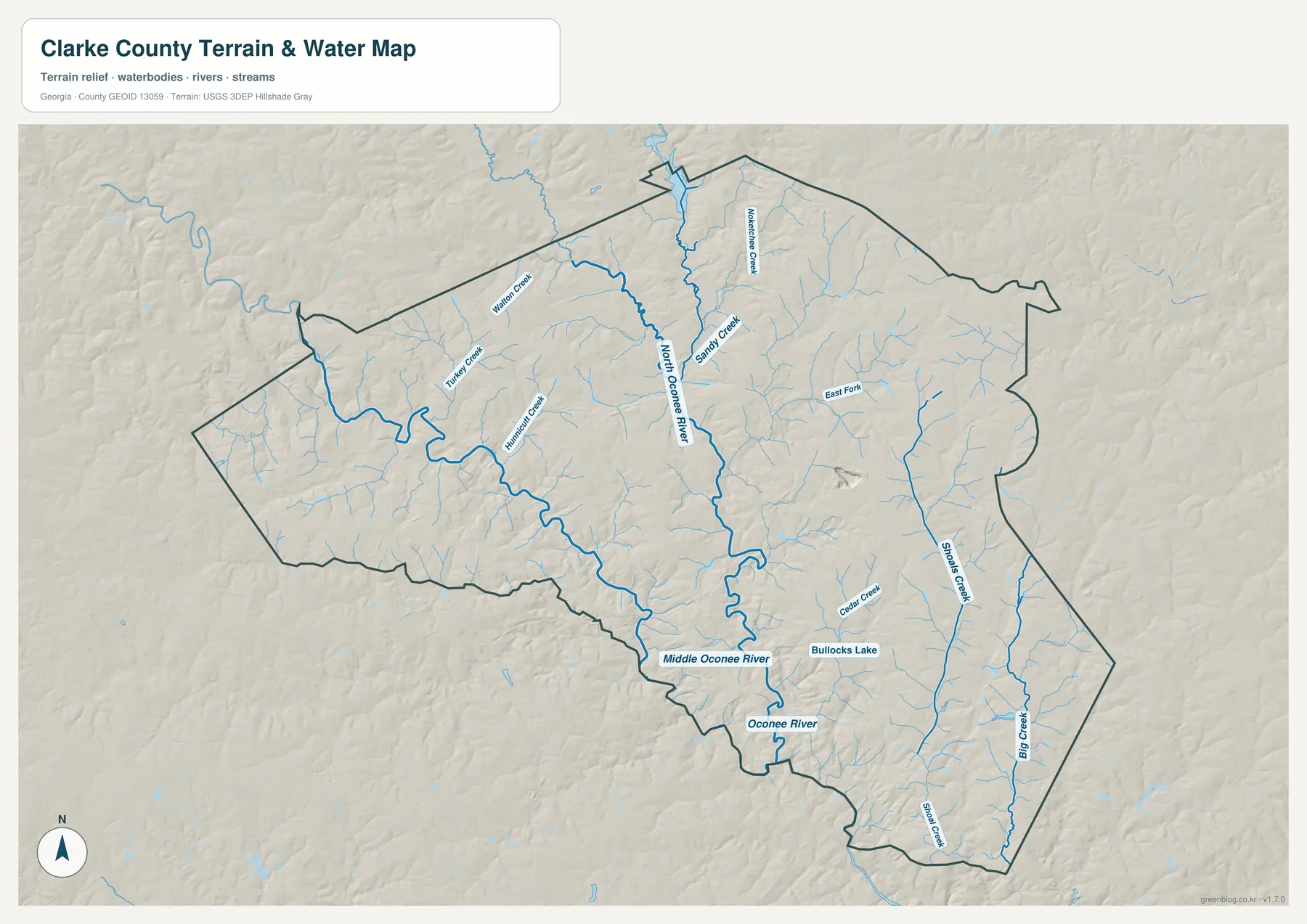
North Oconee River runs close to downtown Athens and the University of Georgia area, while Middle Oconee River creates a second valley system farther west and south. The existing county information records more than 425 miles of streams and rivers, a notable amount of waterway for a jurisdiction this small. Athens-Clarke County also plans around both Oconee rivers, their tributaries, and floodplains as part of a connected greenway system, so the water map is useful for understanding parks and open-space corridors as well as physical geography.
Bullocks Lake is labeled near the south-central part of the water map. The earlier county material also identifies Lake Chapman at Sandy Creek Park in the northern part of the county. These water features make useful reference points, but the map should not be treated as a flood-hazard or property-boundary product. Anyone making a legal, engineering, or flood-risk decision should consult the current county GIS and the appropriate state or federal agency data.
Elevation Map: Piedmont Ridges and Stream Valleys
The elevation map makes Clarke County’s rolling Piedmont setting much easier to see. The map reports an actual elevation range of about 117 to 261 meters, with a mean of 213 meters. Greens mark the lower valley floors, while tan and brown tones pick out higher ground. Instead of one broad flat surface, the county is broken into many short ridges separated by narrow creek and river valleys.
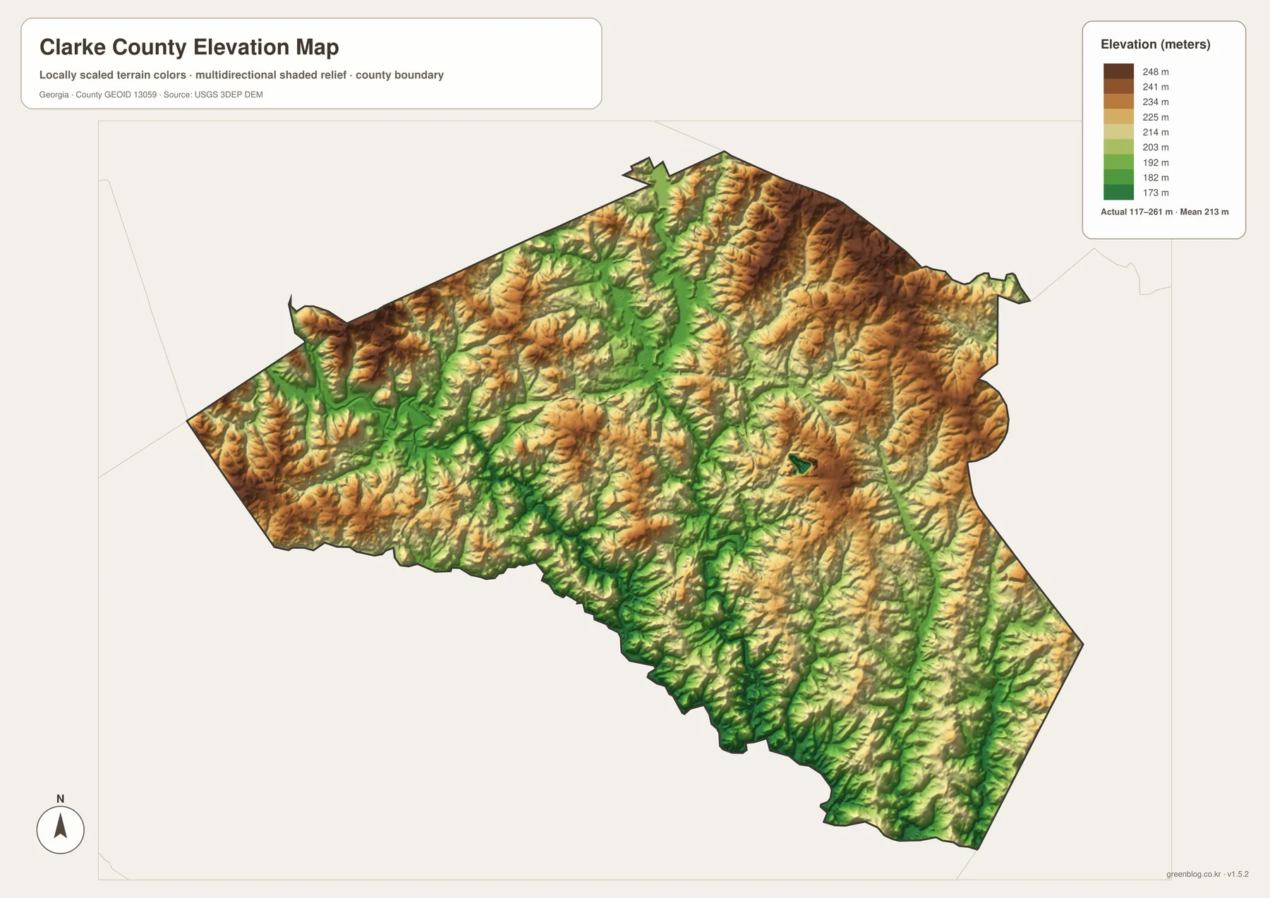
The lower green corridors align closely with the drainage network shown on the water map. Looking at the two maps side by side helps explain why the North and Middle Oconee systems form distinct low corridors and why smaller tributaries leave so many narrow valleys across the county. The higher ridges are often only a short distance from those channels, which means local relief can matter even when two places appear close together on the road map.
The elevation colors are locally scaled to show differences within Clarke County, so the same shade should not be compared directly with a different county map as though the color represented a universal elevation. Use the legend values for actual height. For precise point elevations or terrain analysis, the USGS 3D Elevation Program is the more appropriate source.
Choosing the Right Map for the Task
Use the general county map when you need the fastest overview of the boundary, major roads, Athens, and nearby places. The city map is better for comparing the dominant Athens-Clarke County urban area with Winterville. The water map should be your first choice for tracing the Oconee rivers and tributaries, while the elevation map adds the ridges and low valleys that explain much of the stream pattern.
- County orientation: Compare Athens with the compact county boundary and neighboring counties.
- City pattern: See Athens-Clarke County in relation to Winterville and the western edge near Bogart.
- Road context: Follow the directions of SR 10 Loop, US 29, US 78, US 441, and SR 316.
- Water geography: Trace North Oconee River, Middle Oconee River, Sandy Creek, and smaller tributaries.
- Terrain: Use the elevation legend and shaded relief to distinguish valley floors from higher ridges.
Frequently Asked Questions
Are Athens and Clarke County the same jurisdiction?
The former City of Athens and Clarke County governments unified in 1991 and now operate as Athens-Clarke County Unified Government. The boundaries are not identical in every legal or mapping context, however, because Winterville remains separately incorporated and part of Bogart lies within Clarke County at the western edge.
Why does Clarke County look so densely developed on the map?
Clarke County had 128,671 residents in the 2020 Census within 119.22 square miles of land, producing a reported density of 1,079.2 residents per square mile. Athens and the University of Georgia occupy the central part of that compact area, so roads, institutions, neighborhoods, and the county boundary appear unusually close together.
Can these JPG maps be used for parcel, flood, or navigation decisions?
No. The files are general reference maps designed to show county location, major places, water features, and terrain. Parcel boundaries, legal jurisdiction lines, current road conditions, and flood risk require the latest county GIS or the relevant official agency source.
Map File Information
Download the Clarke County map files
- Included Files: General county map, city map, water map, and elevation map
- File Type: Four high-resolution A3 JPG files in one ZIP archive
- Intended Use: Printing, education, presentations, and map-based projects
Related Maps
Sources and Reference Material
- U.S. Census Bureau QuickFacts: Clarke County, Georgia – population and area
- Athens-Clarke County Unified Government: By the Numbers – local government and county context
- Athens-Clarke County: Oconee Rivers Greenway Commission – river and greenway context
- Athens-Clarke County: Sandy Creek Park and Lake Chapman – northern water feature and park context
- University of Georgia: History and Traditions – Athens university context
- USGS 3D Elevation Program – elevation data reference
Green Map creates custom-edited map images using open geographic data sources such as geoBoundaries, Natural Earth, OpenStreetMap, and government open data. These maps are edited visual materials, not raw data files, and are provided for education, documents, presentations, and graphic reference.