Hinds County combines Mississippi’s capital city with a much larger county that stretches west and south into smaller towns, farms, wooded hills, and creek valleys. The maps on this page make that contrast easy to see: Jackson, Clinton, and Byram are concentrated in the east, while Raymond, Edwards, Utica, and other communities spread across a broader rural area. You can also follow major roads, compare the Pearl River with smaller waterways, and see an elevation range of about 28 to 147 meters. High-resolution JPG versions of all four provided maps are available in one ZIP download for printing or reuse.
Table of Contents
Jackson, Raymond, and the shape of Hinds County
The county map immediately shows that Hinds County is not centered on one compact urban area. Jackson occupies the eastern side, with Clinton just to the west and Byram and Terry extending southward. Raymond sits farther west of the Jackson area, while Bolton and Edwards mark the western I-20 and US 80 corridor and Utica anchors the southwest. This arrangement is useful because it shows how quickly the landscape changes once you leave the capital and its nearby suburbs.
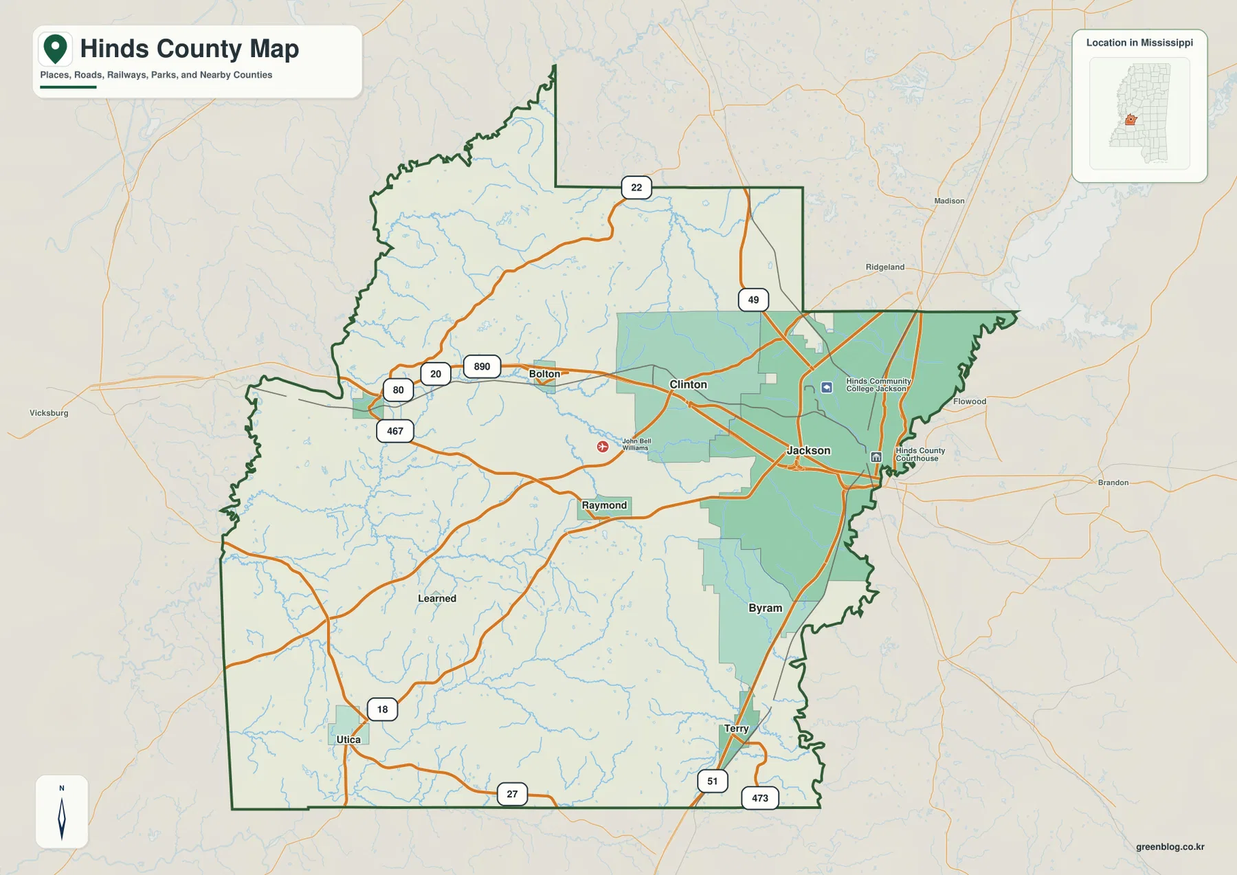
I-20 is the clearest east-west route on the map, crossing Jackson and Clinton before continuing toward Bolton and Edwards. US 80 follows a similar general direction through the northern half of the county. US 49 heads north from Jackson, while US 51 runs south through Byram and Terry. State routes including 18 and 22 help connect the urban side of the county with the much less densely settled west and southwest. For a visitor who only knows Jackson, the road pattern makes the size of Hinds County much easier to understand.
The ranked city map shows a strong eastern concentration
The city map ranks six places and prints a population value beside each name. Jackson is shown first at 146,631, followed by Clinton at 27,195 and Byram at 12,799. Raymond is fourth at 1,663, Terry fifth at 1,620, and Edwards sixth at 930. These labels are most useful as a map-based comparison of the places shown here rather than as a substitute for a separate current population table.
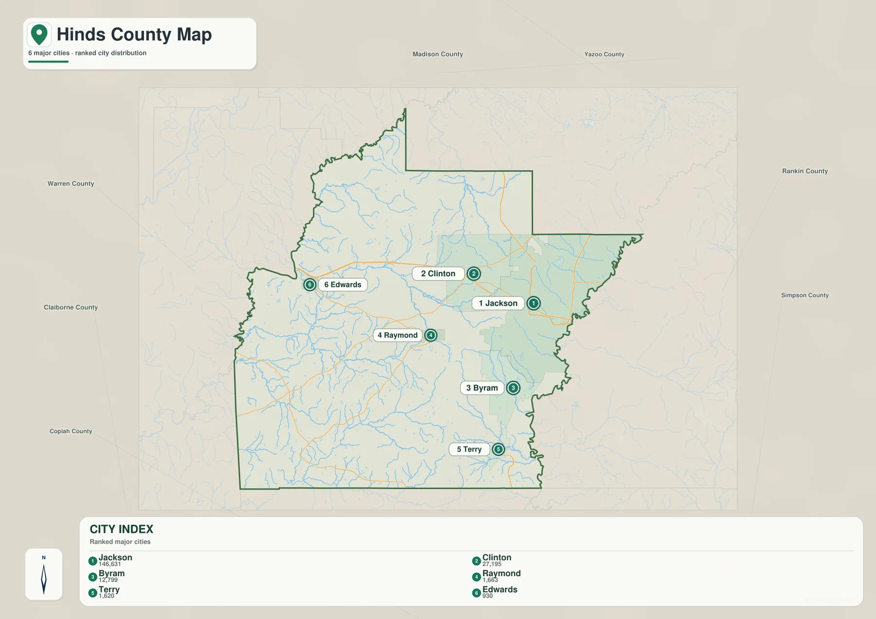
Location matters as much as rank. The three largest places on this map—Jackson, Clinton, and Byram—are all in the eastern half of the county. Raymond is positioned farther west, Terry is near the southern edge, and Edwards is close to the western side. Hinds County also has an unusual administrative feature that helps explain why Raymond remains prominent on a county map: Jackson and Raymond both serve as county seats. Looking at those two places together gives a better picture of the county than treating Jackson as the only center.
Pearl River, creeks, and small lakes across the county
The terrain and water map shifts attention away from highways and city limits. Pearl River is labeled along the southeastern side, while a dense network of smaller waterways crosses the interior. Bakers Creek, Snake Creek, Fourteenmile Creek, Five Mile Creek, and Tallahala Creek are among the named streams visible on the map. Their winding paths help explain why rural Hinds County is broken into many shallow valleys and ridges rather than forming one flat surface.
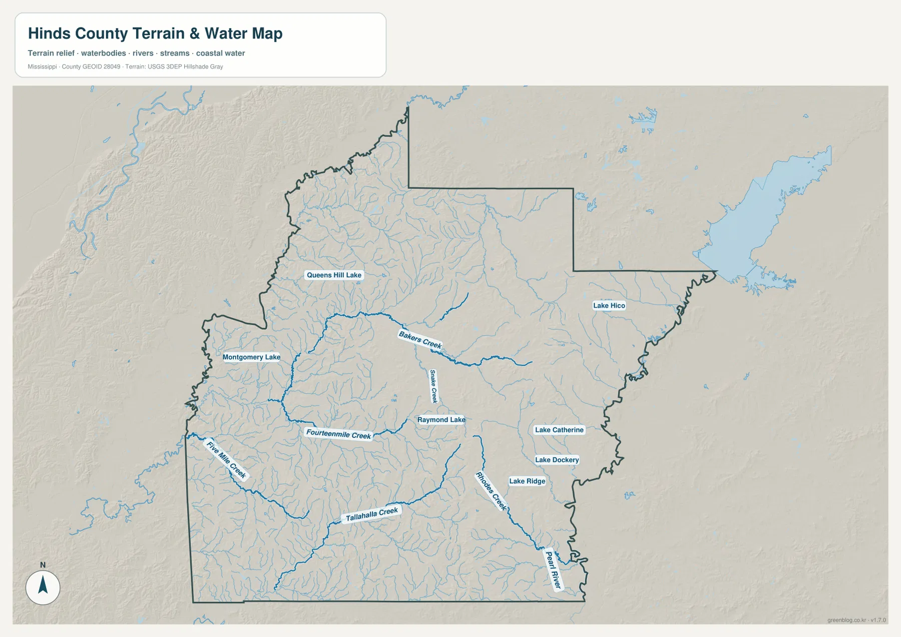
Several named lakes add useful local reference points. Queens Hill Lake and Montgomery Lake appear in the west, Raymond Lake lies near the middle of the county, Lake Hico is toward the northeast, and Lake Catherine, Lake Dockery, and Lake Ridge are grouped on the southeastern side. These labels are valuable when matching communities and roads with nearby water features. The map is a general geographic reference, however, not a flood-hazard, property-boundary, or navigation chart.
A 28–147 m elevation range separates low western ground from eastern hills
The elevation map reports an actual range of roughly 28 to 147 meters and a mean of 80 meters. Lower green tones cover much of the west and southwest, while higher tan and brown terrain is more common in the east and southeast. The difference is not a mountain-versus-plain contrast; it is a pattern of rolling hills, narrow creek valleys, and higher ridges that becomes much more visible when the road labels are removed.
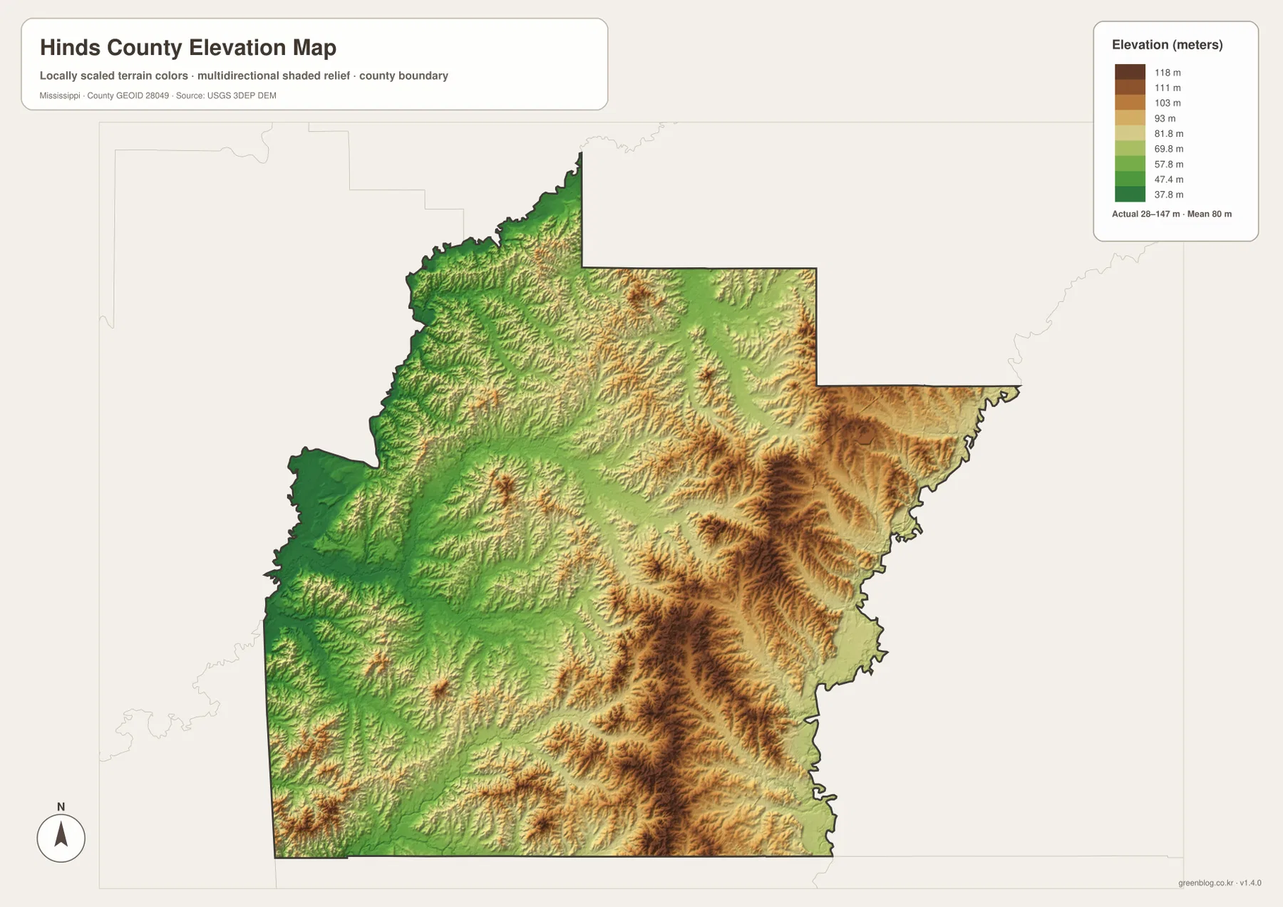
This generalized elevation surface is best used to compare broad parts of the county. It is not survey-grade information for a house lot, road project, drainage design, or construction decision. For classroom work, regional orientation, travel planning, or a presentation about Hinds County, it is useful because it clearly shows where the terrain rises and where lower valleys spread across the map.
Population and area make more sense when paired with the maps
- 2020 Census population: 227,742
- July 2025 population estimate: 211,888
- 2025 Gazetteer land area: 869.845 square miles
- 2025 Gazetteer water area: 7.436 square miles
- 2020 population divided by listed land area: about 261.8 residents per square mile
A countywide density number can hide the distribution shown on the city map. A large share of the visible urban concentration is around Jackson, Clinton, and Byram, while western and southwestern Hinds County cover a much larger rural area with smaller towns and long stretches between communities. The 2020 Census count and the July 2025 estimate also represent different dates, so they should not be treated as measurements from the same point in time. The land and water figures are listed separately to make the county’s physical size clearer.
Choosing the map file that fits your task
Use the county reference map when you need roads, community locations, and the overall boundary in one view. The ranked city map is better for comparing the relative prominence and placement of Jackson, Clinton, Byram, Raymond, Terry, and Edwards. Choose the water map when Pearl River, creeks, or lakes matter to the explanation, and use the elevation map when the main point is the contrast between lower western terrain and the hillier east. The downloadable JPG originals are useful for print layouts, presentations, personal editing, and other projects that need more resolution than the WEBP previews shown in the article.
Frequently Asked Questions
Why are both Jackson and Raymond important on a Hinds County map?
Hinds County has county-seat functions in both Jackson and Raymond. Jackson is the state capital and the largest city shown, while Raymond is an important administrative reference for the central and southwestern part of the county. Seeing both locations helps explain why the county cannot be understood only as the Jackson urban area.
Which part of Hinds County appears higher on the elevation map?
The map shows more of the higher tan and brown terrain in the east and southeast, while broad green areas in the west and southwest are lower. The displayed countywide range is about 28 to 147 meters with a mean of 80 meters.
What is included in the downloadable Hinds County map ZIP?
The archive contains high-resolution JPG originals for the county reference map, ranked city map, terrain and water map, and elevation map. The WEBP images in the article are lighter previews intended for on-page viewing.
Sources and Reference Data
- U.S. Census Bureau Hinds County QuickFacts
- U.S. Census Bureau Gazetteer Files
- Mississippi Department of Transportation official highway map
- USGS National Hydrography
- USGS 3D Elevation Program
- Hinds County official website
Map File Information
The ZIP contains the four high-resolution A3 JPG originals used for the county, city, water, and elevation references on this page.
- Included Files: county map, ranked city map, terrain and water map, elevation map
Related Maps
Green Map creates custom-edited map images using open geographic data sources such as geoBoundaries, Natural Earth, OpenStreetMap, and government open data. These maps are edited visual materials, not raw data files, and are provided for education, documents, presentations, and graphic reference.