Benton County sits along Mississippi’s northern edge, directly below Tennessee, and its geography makes more sense when roads, small communities, streams, and relief are viewed together. Ashland is the county seat and the main reference point near the middle of the county, but it is not the only place that matters for orientation. US 72 crosses the northern part of the county, Hickory Flat anchors the south, Lamar lies toward the northwest, and Snow Lake Shores sits west of Ashland near a cluster of small lakes. This page brings those relationships together with a county reference map, a city-connections map, a terrain-and-water map, and an elevation map. The on-page images are WebP previews, while the download box provides the matching high-resolution A3 JPG files in one ZIP archive.
The maps are most useful when treated as complementary views of the same county rather than as four versions of one picture. The road map explains how Ashland connects with US 72 in the north and the US 78 area near Hickory Flat in the south. The water map reveals a dense network of headwater streams and small lakes, including the Wolf River system in the north and the Tippah River farther south. The elevation layer then shows why those streams branch so often: Benton County is a landscape of ridges and narrow lower valleys, with mapped elevations ranging from about 95 to 235 meters.
Table of Contents
Ashland, the Tennessee Line, and Benton County’s Road Pattern
Benton County occupies a long north-to-south area in northern Mississippi. Tennessee forms its northern boundary, while Marshall County is shown to the west, Tippah County to the east, and Union County toward the southwest on the supplied maps. The outline is not a simple rectangle; several steps and indentations along the southern and eastern sides make a county map especially helpful when comparing Benton with its neighbors. Ashland lies away from the outer boundary and works as a practical center point for reading the rest of the map.
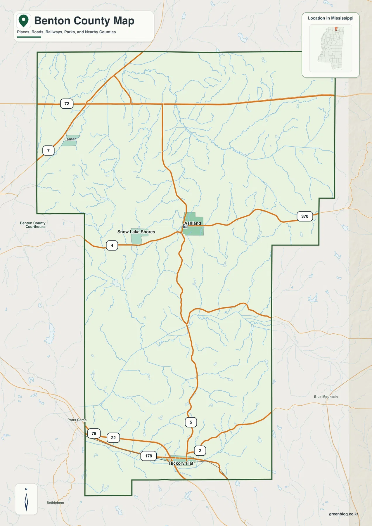
The northern road pattern is dominated by US 72, which runs east-west across the upper part of the county. MS 7 approaches from the northwest near Lamar and meets that corridor. In the central area, MS 5 passes through Ashland and continues south, while MS 4 extends west from the Ashland area and MS 370 heads east. Farther south, the road network changes character around Hickory Flat, where US 78 and routes including MS 178 and MS 2 create another important set of connections. This means a trip across Benton County can involve very different corridors depending on whether the destination is in the northern, central, or southern part of the county.
That distinction is easy to miss if Ashland is treated as the only transportation center simply because it is the county seat. Ashland is important for county government and central orientation, but the main east-west highways do not all pass through it. US 72 is well to the north, while the US 78 corridor is near the southern end. The map therefore separates three useful reference areas: the northern highway belt near Lamar, the central Ashland area, and the southern connections around Hickory Flat.
Small Communities Spread Across a Rural County
The source material in the package lists 7,646 residents in the 2020 census and a July 2025 estimate of 7,502. The 2025 Gazetteer figures are 406.616 square miles of land and 2.038 square miles of water. Those numbers provide useful scale: Benton covers a substantial area, but its population is small enough that the map is not filled with continuous urban development. Instead, named communities appear as separate reference points connected by state and federal routes, with large rural spaces between them.
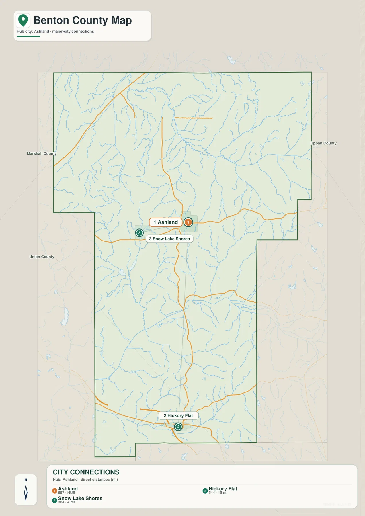
Ashland is the county seat and the map’s principal hub. Snow Lake Shores is close by to the west and is associated with the lake area around Big Snow Lake. Hickory Flat is much farther south and sits near the southern highway network. The city-connections map is useful because it strips away some of the road detail and makes the relative placement of these three communities easier to see. For a classroom handout, county profile, or local-history page, this view can communicate the settlement pattern faster than a more crowded road map.
Lamar, shown on the general county map, adds a fourth point of reference in the northwest near MS 7 and US 72. Together, these places show that Benton County does not have one compact urban cluster that defines the whole county. The northern highway corridor, central county-seat area, lake-oriented settlement west of Ashland, and southern Hickory Flat area each occupy different parts of the map. That spread is one reason the full county boundary and road network are useful when explaining local geography.
Wolf River Headwaters, Tippah River, and the County’s Many Small Streams
The terrain-and-water map makes Benton County look much more intricate than the road map because narrow blue streams cover most parts of the county. In the north, the Wolf River is a major labeled feature, joined by smaller waterways that include Grogg Creek and Indian Creek on the eastern side. Grays Creek appears farther west. These channels branch repeatedly into shorter tributaries, giving the northern half of the map a dense headwater pattern rather than a single broad river valley.
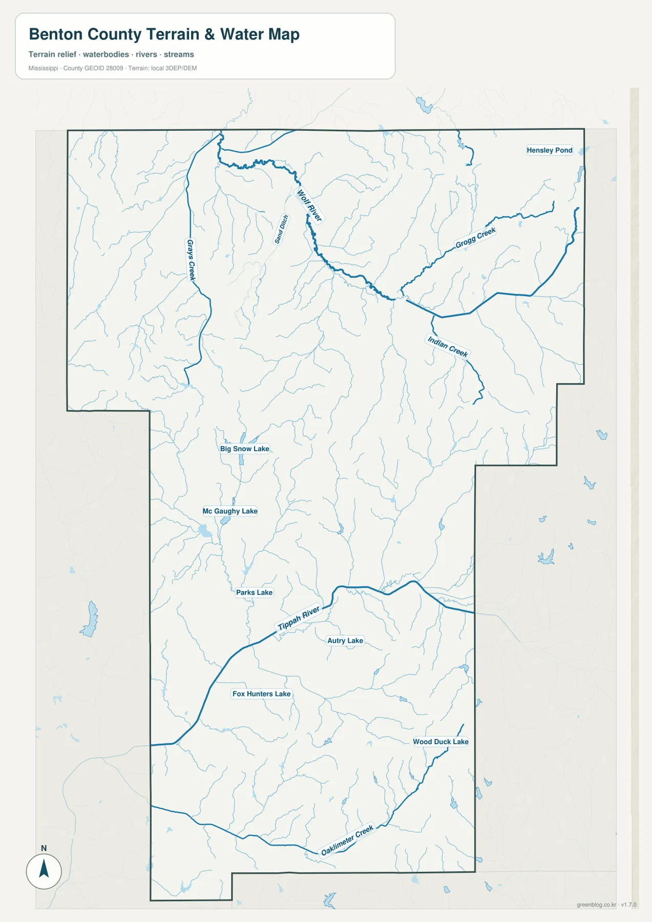
South of the county’s midpoint, the Tippah River becomes the most prominent labeled watercourse. Several lakes are also easy to locate on this map. Big Snow Lake and Mc Gaughy Lake lie west of the central area, Parks Lake and Autry Lake appear farther south, and Fox Hunters Lake and Wood Duck Lake provide additional landmarks in the lower half of the county. The map is valuable not because these water bodies are large, but because it shows how frequently small lakes and streams occur between the ridges.
Comparing this layer with the road map helps explain local orientation. Roads generally appear as a few stronger lines connecting communities, while the drainage network fills the spaces between them with many smaller channels. Around Ashland, for example, roads cross a landscape already divided by tributaries. Near the southern part of the county, the Tippah River and its branches create another broad set of low corridors. This map should be used as a county-scale reference rather than as a navigation chart for boating, fishing access, property boundaries, or public access rights.
A 95–235 Meter Elevation Range Reveals Ridges and Valleys
The elevation map provides the clearest visual explanation for the drainage pattern. Its legend gives an actual mapped range of roughly 95 to 235 meters, with a mean elevation of 152 meters. Browns and tans mark relatively higher ground, while greens identify lower areas. The result is a strongly textured surface in which narrow ridges are separated by branching valleys rather than a broad, level plain.
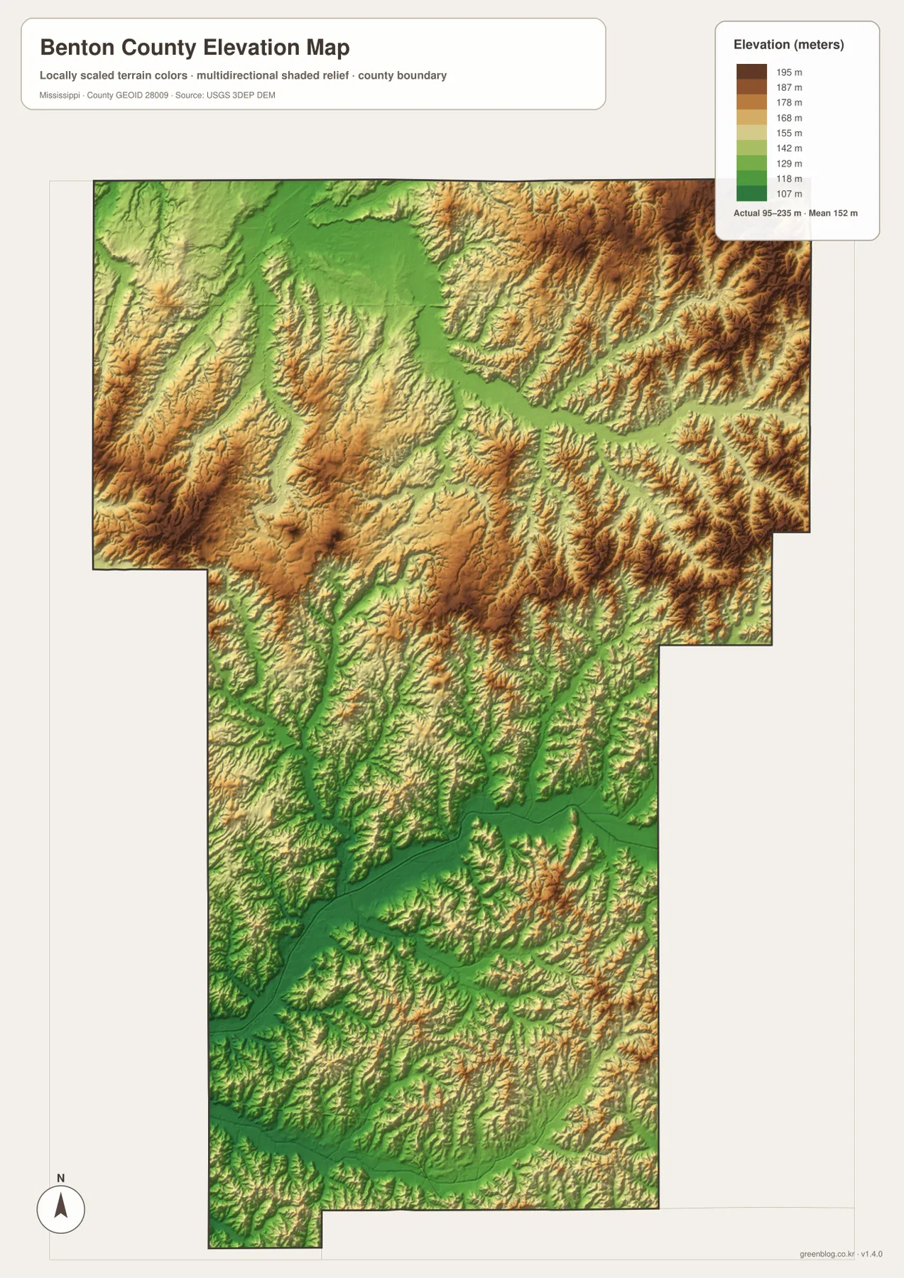
Higher terrain is especially visible across parts of the east and northeast, where tan and brown ridges are closely spaced. Lower green corridors cut through the center and continue into the southern half along drainage lines. The west also contains repeated ridge-and-valley forms, so the county’s relief is not confined to one corner. When the elevation and water maps are viewed side by side, many of the blue tributaries correspond to the lower green channels between higher slopes.
This is a county-wide elevation reference, not a substitute for a surveyed elevation at a specific house, parcel, trail, or bridge. Its strength is comparison. A reader can quickly see which parts of Benton County are relatively high, where lower valleys form, and why a seemingly modest rural county has such a complex pattern of streams. The shaded relief also makes the county’s north-south extent easier to appreciate because the same ridged terrain continues across multiple road corridors and community areas.
Benton County Map Facts at a Glance
- State and county: Mississippi, Benton County
- FIPS code: 28009
- County seat: Ashland
- Selected mapped communities: Ashland, Hickory Flat, Snow Lake Shores, and Lamar
- 2020 census population: 7,646
- July 2025 population estimate in the supplied source material: 7,502
- 2025 Gazetteer area: 406.616 sq mi land and 2.038 sq mi water
- Major road references on the maps: US 72, US 78, MS 5, MS 7, MS 4, MS 370, and MS 178
- Major mapped water references: Wolf River, Tippah River, tributaries, and several small lakes
- Elevation-map range: about 95–235 m, mean 152 m
The population and area figures answer different questions and should not be treated as a single measure of where people live. Census counts and estimates describe residents at specific reference dates, while Gazetteer data describes the county’s land and water area. The maps add the missing geographic context by showing where named communities, transportation routes, streams, lakes, and higher or lower terrain actually occur within that area.
Choosing the Right Map and Downloading the JPG Files
Use the general county map when the main goal is to identify communities, highways, and the county boundary in one view. The city-connections map is better when Ashland, Hickory Flat, and Snow Lake Shores need to stand out without as much road detail. For rivers, creeks, and lakes, the terrain-and-water map is the clearest choice. The elevation map is most useful for explaining the county’s ridges, valleys, and relative height differences.
The WebP images on this page are optimized for online viewing. For printing, slide decks, document design, or image editing, the download archive contains four separate high-resolution A3 JPG files corresponding to the maps shown above. Keeping the files separate makes it possible to use only the layer needed for a project or to place multiple maps side by side when comparing roads, water, and terrain.
Frequently Asked Questions
Does Ashland sit on Benton County’s main east-west highway?
No. Ashland is the county seat and an important central road junction, but US 72 crosses the northern part of the county and US 78 is near the southern Hickory Flat area. The map is useful for distinguishing the administrative center from the two major east-west highway corridors.
Which rivers stand out on the Benton County water map?
The Wolf River system is prominent in the northern half, while the Tippah River is the clearest labeled river farther south. Numerous tributaries and small lakes, including Big Snow Lake and Parks Lake, fill in the drainage pattern between those larger references.
What elevation range is shown for Benton County?
The supplied elevation map shows an actual range of about 95 to 235 meters and a mean of 152 meters. It is designed for county-scale comparison, so it shows relative ridges and valleys rather than surveyed elevations for individual properties.
Sources and Reference Material
The article uses the supplied Benton County map images for labeled roads, communities, waterways, and elevation patterns, together with the public reference sources listed in the package for population, area, boundary, hydrography, and elevation context.
- U.S. Census Bureau QuickFacts – Benton County, Mississippi
- U.S. Census Bureau Gazetteer Files
- U.S. Census Bureau TIGER/Line Shapefiles
- USGS National Hydrography
- USGS 3D Elevation Program
- Mississippi Encyclopedia – Benton County
Map File Information
The ZIP contains high-resolution A3 JPG versions of the Benton County reference, city-connections, terrain-and-water, and elevation maps shown on this page.
- Included Files: County map, city map, water map, elevation map
Related Maps
Green Map creates custom-edited map images using open geographic data sources such as geoBoundaries, Natural Earth, OpenStreetMap, and government open data. These maps are edited visual materials, not raw data files, and are provided for education, documents, presentations, and graphic reference.