Bolivar County stretches along the western side of the Mississippi Delta, where the county line repeatedly follows broad bends of the Mississippi River. Cleveland lies well inland on the eastern side of the county, while Rosedale sits much closer to the river. Shelby, Mound Bayou, Renova, and Shaw form another set of reference points farther east. The maps on this page make those relationships easier to compare, and the matching high-resolution A3 JPG files are available together as a downloadable ZIP.
The county is unusually long from north to south, and its western outline is anything but straight. Several river bends push the boundary east and west, while a dense network of interior streams and drainage channels crosses the Delta plain. Roads such as US 61 and MS 1 run through different parts of the county, so a road-only view does not tell the whole story. Looking at the county, city, water, and elevation maps together gives a much clearer picture of how communities, routes, and waterways fit within the same boundary.
These four supplied maps are not duplicate versions of one graphic. The county map is best for the overall road and place pattern, the city map strips the view down to six ranked communities, the terrain-and-water map names rivers, bayous, and lakes, and the elevation map shows a local range of roughly 33 to 56 meters with a mean near 42 meters. That narrow elevation range is an important clue: Bolivar County is not a place of large mountain relief, but small changes in height still matter when reading a flat Delta landscape.
Table of Contents
A long Delta county framed by Mississippi River bends
On the county map, the western edge forms a sequence of deep curves rather than a simple north–south line. Rosedale and Beulah sit near this river side, while Gunnison and Benoit help mark other parts of the western half. The eastern boundary is much straighter, and several of the county’s better-known communities line up closer to that side. This makes the map easy to read as a contrast between a river-shaped west and a more linear eastern settlement and road corridor.
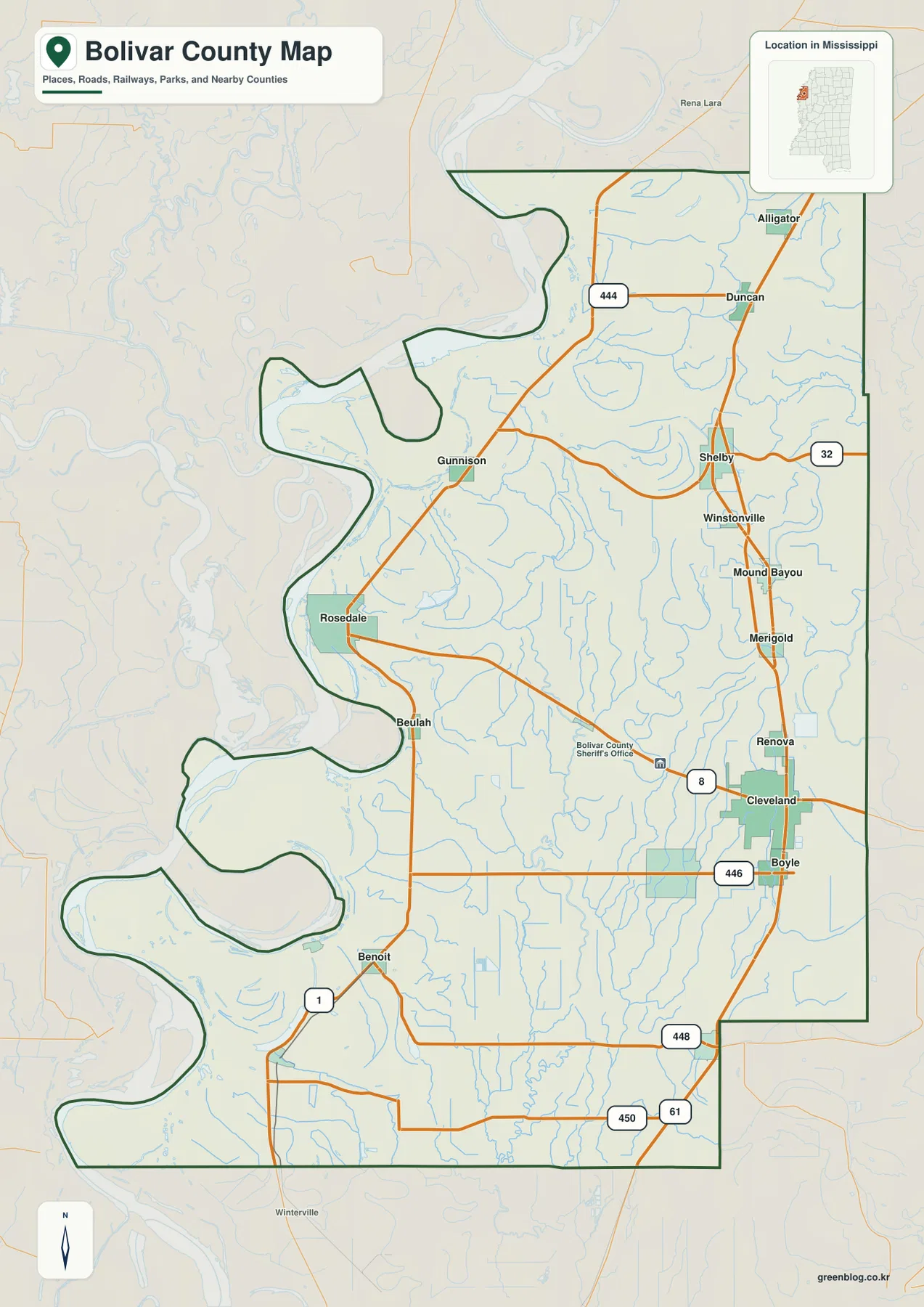
The road labels reinforce the county’s north–south scale. Route 444 appears near Duncan in the north, MS 32 crosses the Shelby area, MS 8 runs through Cleveland, and routes 446, 448, and 450 help orient the central and southern sections. US 61 enters the southeastern part of the county, while MS 1 stays farther west and connects the river-side corridor through places such as Rosedale and Benoit. The two routes run in broadly similar directions but serve noticeably different strips of the county.
That separation is useful when planning a simple reference map for a report or lesson. A marker placed at Cleveland does not represent the river side, and a marker placed at Rosedale does not represent the eastern US 61 corridor. Bolivar County works better as a set of linked local areas than as a county with one obvious visual center.
Cleveland and Rosedale anchor different parts of the county
Bolivar County has two county seats, Cleveland and Rosedale, and the map makes their separation immediately visible. Cleveland sits in the eastern interior, slightly south of the county’s midpoint, while Rosedale is west of it near a large Mississippi River bend. Their locations help explain why the county is often easier to understand through two reference points rather than one.
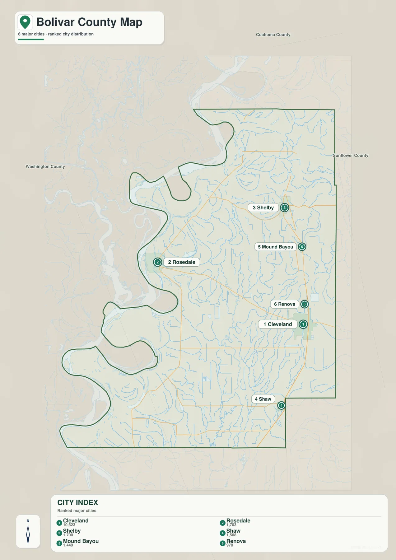
The supplied city index ranks Cleveland first and shows a value of 10,623. Rosedale is labeled 1,703, Shelby 1,700, Shaw 1,508, Mound Bayou 1,449, and Renova 978. Those figures are presented here as values printed on the supplied city map rather than as a newly calculated current population series. The useful geographic point is the distribution: Shelby and Mound Bayou sit to the north of Cleveland on the eastern side, Renova is close to Cleveland, Shaw is farther south, and Rosedale stands apart near the river.
| Community | Position on the supplied map | City-index value |
|---|---|---|
| Cleveland | East-central, slightly south of center | 10,623 |
| Rosedale | Western river side | 1,703 |
| Shelby | Northeast | 1,700 |
| Shaw | Southeast | 1,508 |
| Mound Bayou | Eastern interior, north of Cleveland | 1,449 |
| Renova | Just north of Cleveland | 978 |
This pattern is more informative than a simple ranked list. The city map shows a cluster of labeled communities along the eastern half, while Rosedale occupies a separate river-side position. For someone comparing travel corridors, county services, or historical places, that spacing is the first thing to understand before looking at smaller roads or individual waterways.
Roads reveal how far the county extends from north to south
US 61 is a strong visual reference on the eastern and southeastern side of Bolivar County. It passes near the Cleveland area and continues toward the southern boundary. MS 1, by contrast, follows a western corridor closer to the Mississippi River and connects places such as Rosedale and Benoit. Seeing both routes at once makes it easier to understand that the county contains parallel north–south travel paths separated by a wide expanse of Delta land.
East–west roads help tie those corridors together. MS 8 crosses Cleveland, route 446 runs just to the south toward Boyle, and MS 32 crosses near Shelby farther north. Routes 444, 448, and 450 appear in other sections, giving the map several horizontal reference lines. Because the county boundary bends so strongly on the west, an east–west trip is not always visually comparable from one part of the county to another.
For a printed reference sheet, it can be useful to mark the river-side corridor and the US 61 corridor separately before adding destinations. This avoids the common impression that all major communities sit along one highway. Bolivar County’s map makes more sense when the road network is read together with the river boundary and the location of the two county seats.
The interior water network is as important as the river edge
The terrain-and-water map adds much more detail than the general county map. In the north, Hushpuckena River crosses the eastern side, with Buck Lake and Howden Lake nearby. Farther south, Bogue Phalia runs through the interior, while Porter Lake and Conservation League Lake provide additional reference points. Big Sunflower River appears along the eastern side and continues south through a dense pattern of smaller channels.
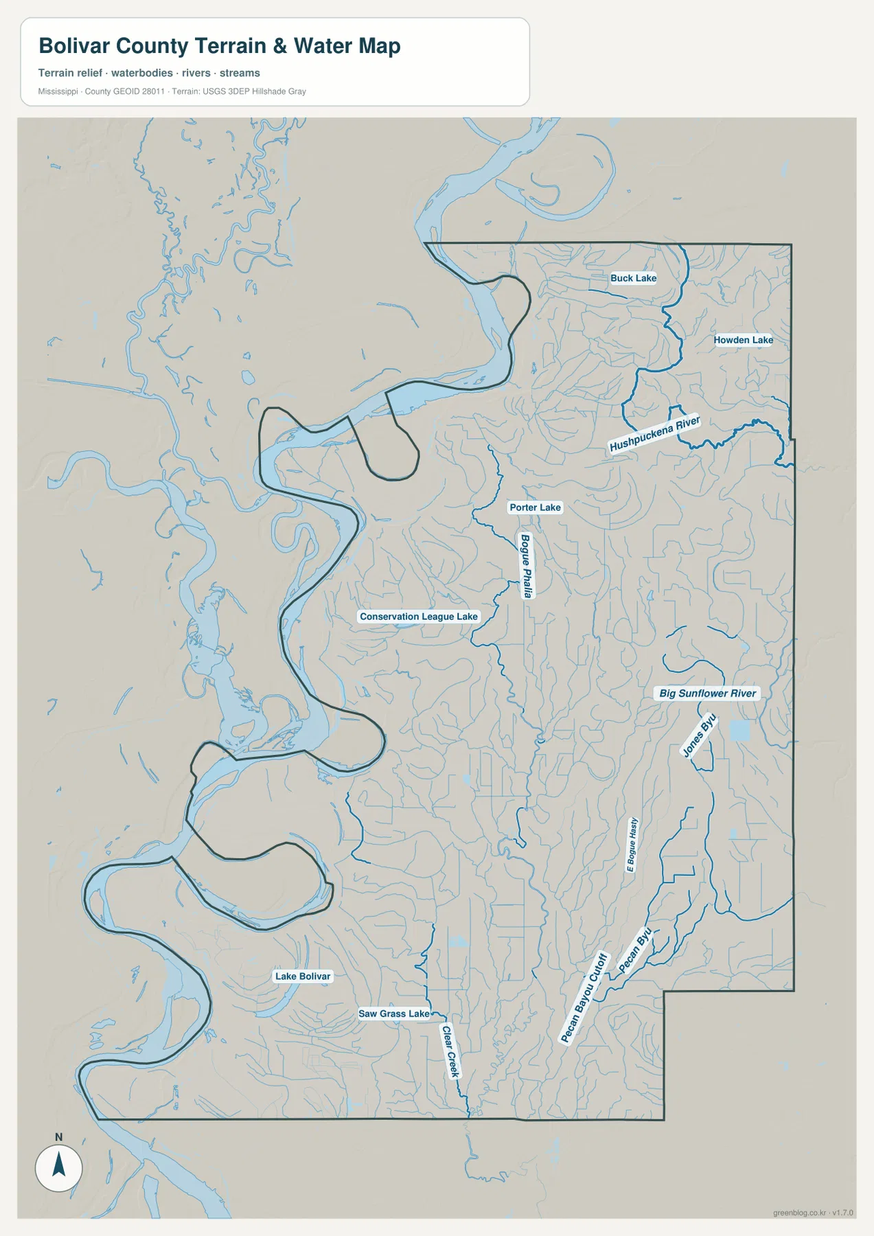
The southern half adds Lake Bolivar and Saw Grass Lake, while Pecan Bayou and related channels appear toward the southeast. Many thinner blue lines fill the space between the named features. On the regular road map these channels can fade into the background, but on the water map they explain why the Delta plain looks so finely divided and why a straight-line view between two towns can miss an important part of the landscape.
Rosedale and Cleveland illustrate that difference well. Rosedale is tied visually to a large western river bend, whereas Cleveland sits amid the interior drainage network. The water map therefore works best when the question is not simply “Where is the Mississippi River?” but “Which rivers, bayous, and lakes lie between the county’s communities and roads?”
A 33–56 meter elevation range still shows local relief
The elevation map reports an actual range of about 33 to 56 meters, with a mean near 42 meters. That is a narrow spread compared with a hill or mountain county, so the map should not be read as evidence of steep terrain. Its value is in showing relative differences across a very low Delta landscape. Brown and tan areas are more common in parts of the north and along some older curved landforms, while greener low areas become more prominent farther south and southeast.
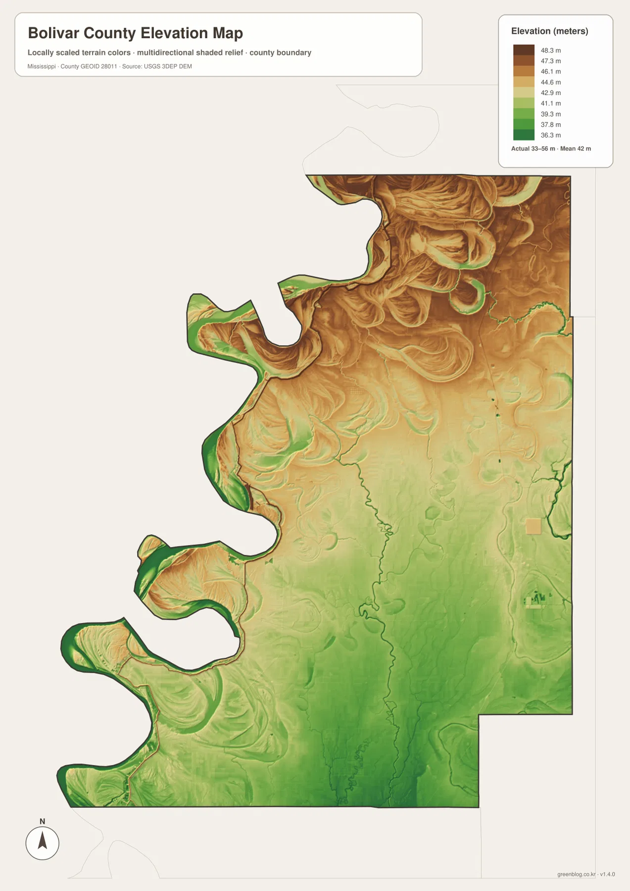
The most interesting shapes are often curved rather than straight. Around river bends and former channel-like features, elevation colors wrap around the same kinds of forms that appear on the water map. Comparing the two maps side by side can make those relationships easier to recognize, even though the total vertical difference across the county remains modest.
The elevation image is a county-scale reference, not a flood-risk or engineering map. It should not be used by itself to judge levee safety, property flood exposure, drainage performance, or development suitability. Those questions require current, purpose-built public data. Here, the elevation map is most useful for understanding why a “flat” Delta county can still contain visible local relief and why water features often follow subtle changes in the land surface.
Choose the map by the question you need to answer
Start with the county map when you need the broad relationship among Cleveland, Rosedale, major roads, and the boundary. Switch to the city map when the goal is to compare the six highlighted communities without as much background detail. The water map is the stronger choice for Hushpuckena River, Bogue Phalia, Big Sunflower River, and the named lakes, while the elevation map is the quickest way to compare relative highs and lows within the 33–56 meter range.
- Overall places, boundaries, and road references: county map
- Relative positions of Cleveland, Rosedale, Shelby, Shaw, Mound Bayou, and Renova: city map
- Named rivers, bayous, lakes, and dense interior channels: terrain-and-water map
- Small elevation differences across the Delta plain: elevation map
The WebP images in the article are intended for fast viewing. The download package contains the matching high-resolution A3 JPG files, so it is better suited to printing, adding notes, placing a map in a presentation, or keeping an offline reference copy. All four JPG maps are bundled in one ZIP rather than requiring separate downloads.
Frequently Asked Questions
Why are both Cleveland and Rosedale important on a Bolivar County map?
Bolivar County has two county seats, and they occupy different parts of the map. Cleveland is in the eastern interior, while Rosedale is near the Mississippi River on the west. Using both as reference points makes the county’s long east–west separation and dual administrative pattern much easier to understand.
Does the Mississippi River tell the whole water story of Bolivar County?
No. The river forms the major western edge, but the supplied water map also labels Hushpuckena River, Bogue Phalia, Big Sunflower River, several lakes, and many smaller channels inside the county. Those interior waterways are essential for understanding the Delta landscape between the main communities.
What does the elevation map show if Bolivar County is mostly flat?
It shows relative height differences within a small local range. The legend gives roughly 33 to 56 meters with a mean near 42 meters. That is not mountainous relief, but the color changes help reveal subtle higher and lower areas that can be compared with river bends and drainage features.
Sources and Reference Data
Population and area references can be checked against U.S. Census Bureau material, road context against the Mississippi Department of Transportation map, and the water and elevation layers against USGS programs. These links are appropriate for verifying the underlying geographic context; for current legal, hazard, or property decisions, consult the most recent agency data created for that specific purpose.
- U.S. Census Bureau QuickFacts – Bolivar County
- U.S. Census Bureau Gazetteer Files
- Mississippi Department of Transportation official highway map
- USGS National Hydrography
- USGS 3D Elevation Program
- Mississippi Encyclopedia – Bolivar County
Map File Information
The download includes the Bolivar County reference, city, terrain-and-water, and elevation maps as high-resolution A3 JPG files in one ZIP archive.
- Included Files: County map, city map, terrain-and-water map, elevation map
Related Maps
Green Map creates custom-edited map images using open geographic data sources such as geoBoundaries, Natural Earth, OpenStreetMap, and government open data. These maps are edited visual materials, not raw data files, and are provided for education, documents, presentations, and graphic reference.