Wilson County lies in southeastern Kansas, where Fredonia serves as the county seat and Neodesha forms the largest city index on the supplied map. Altoona, Buffalo, New Albany, and Coyville are smaller rural references scattered among rolling hills and major drainage valleys. US 400 crosses the central part of the county, US 75 links Altoona and Neodesha, and the Verdigris and Fall rivers create the broadest lowlands. High-resolution map files are available for download in the section below.
This guide follows Fredonia, Neodesha, the road network, major streams, and terrain ranging from about 231 to 346 meters. WebP previews are available for quick viewing, and the matching high-resolution JPG files can be downloaded together in one ZIP for printing, classroom work, or offline reference.
Table of Contents
Fredonia provides the county-seat and central-road reference
Fredonia sits slightly west of the county center, with K-39 running north–south and US 400 passing north of town through the Benedict area. Altoona lies to the east near K-47 and US 75, while Neodesha is farther south on the US 75 corridor.
The Kansas Historical Society identifies Fredonia as the Wilson County seat. The county went through repeated elections and legal disputes over the location of the seat before Fredonia became the final choice. That history is reflected in the present map, where county administrative facilities remain concentrated in Fredonia.
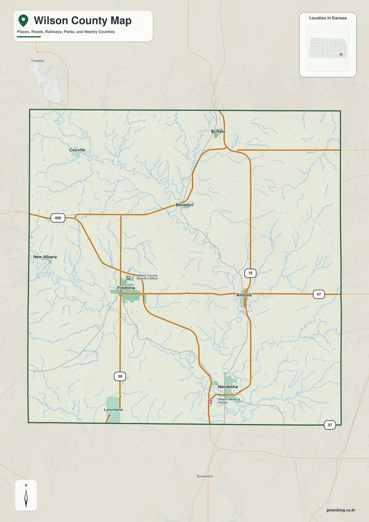
Buffalo provides a northern reference near US 75, while Coyville lies in the northwest. New Albany sits close to the western boundary. Neodesha occupies a lower river setting in the south, giving it a different physical context from Fredonia’s more central upland location.
Neodesha leads the city index, followed by Fredonia
The supplied city panel ranks Neodesha at 2,503, Fredonia at 1,945, Altoona at 467, Buffalo at 282, New Albany at 88, and Coyville at 62. These are map index values rather than current official population estimates.
The ranking creates an interesting contrast with county government: Fredonia is the county seat, but Neodesha has the larger city index. Altoona sits between the two larger centers on the eastern road network, while Buffalo, New Albany, and Coyville provide smaller references across the northern and western countryside.
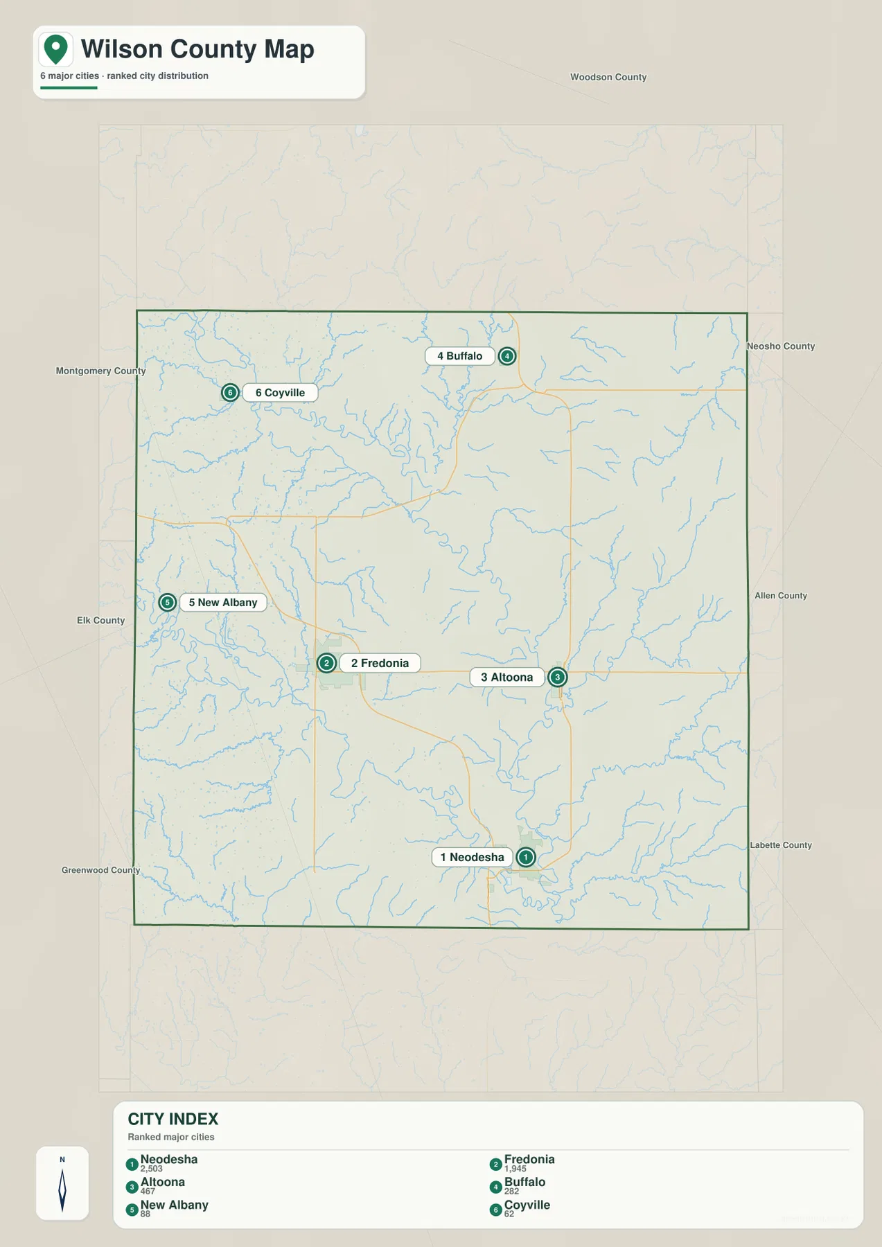
The Kansas Historical Society treats both Fredonia and Neodesha as important Wilson County communities. Official census figures and the supplied map index are different datasets and should not be used interchangeably, but both cities clearly anchor much of the county’s population and services.
The Verdigris and Fall rivers create the county’s broadest lowlands
The Verdigris River is the dominant drainage line. It enters from the northwest, bends across the central county, and continues toward the southeast. Toronto Reservoir appears just beyond the northwestern boundary, providing an upstream reference for the larger Verdigris system.
The Fall River crosses the southwestern side and approaches the Verdigris drainage through the south-central county. West Rainbow Creek, East Rainbow Creek, and Salt Creek divide the surrounding uplands and form long tributary valleys.
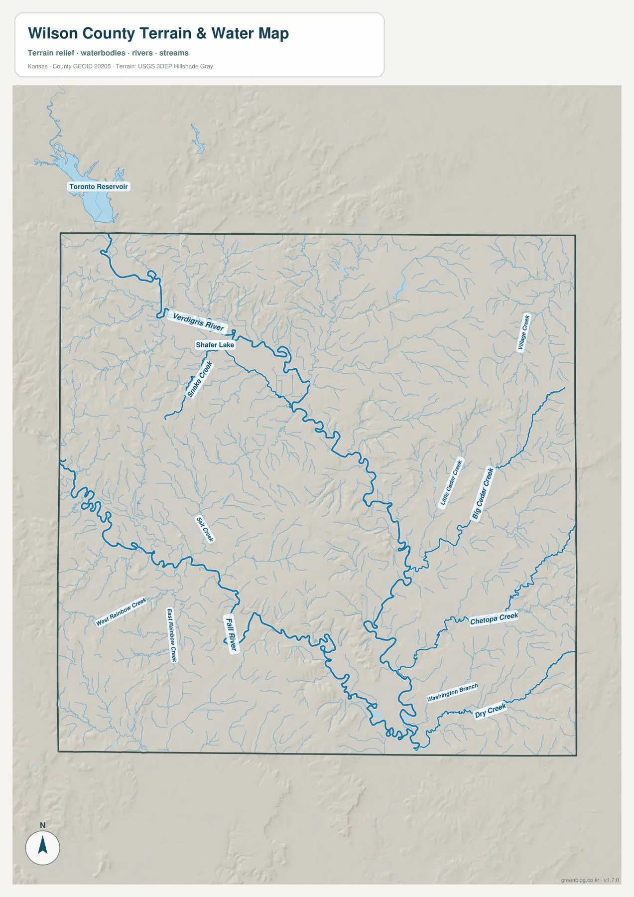
Big Cedar Creek and Little Cedar Creek descend through the eastern half, while Chetopa Creek and Dry Creek form additional southeastern corridors. Shafter Creek and Shafter Lake provide useful northwestern references between the Buffalo and Fredonia sides.
This image is intended for geographic reference rather than floodplain, navigation, water-quality, parcel, or legal-access decisions. River and lake conditions can change, so current agency information should be used whenever access or safety matters.
Elevation from 231 to 346 meters separates river bottoms from the Chautauqua Hills
The elevation surface ranges from about 231 to 346 meters, with a mean near 281 meters. Broad green lowlands follow the Verdigris and Fall rivers, while tan and brown ridges rise across the west, northwest, and parts of the east.
The Kansas Historical Society places Wilson County across the Osage Cuestas and Chautauqua Hills physiographic regions. That combination fits the relief image: steep short ridges sit close to broad stream bottoms, producing much more local variation than a flat road map suggests.
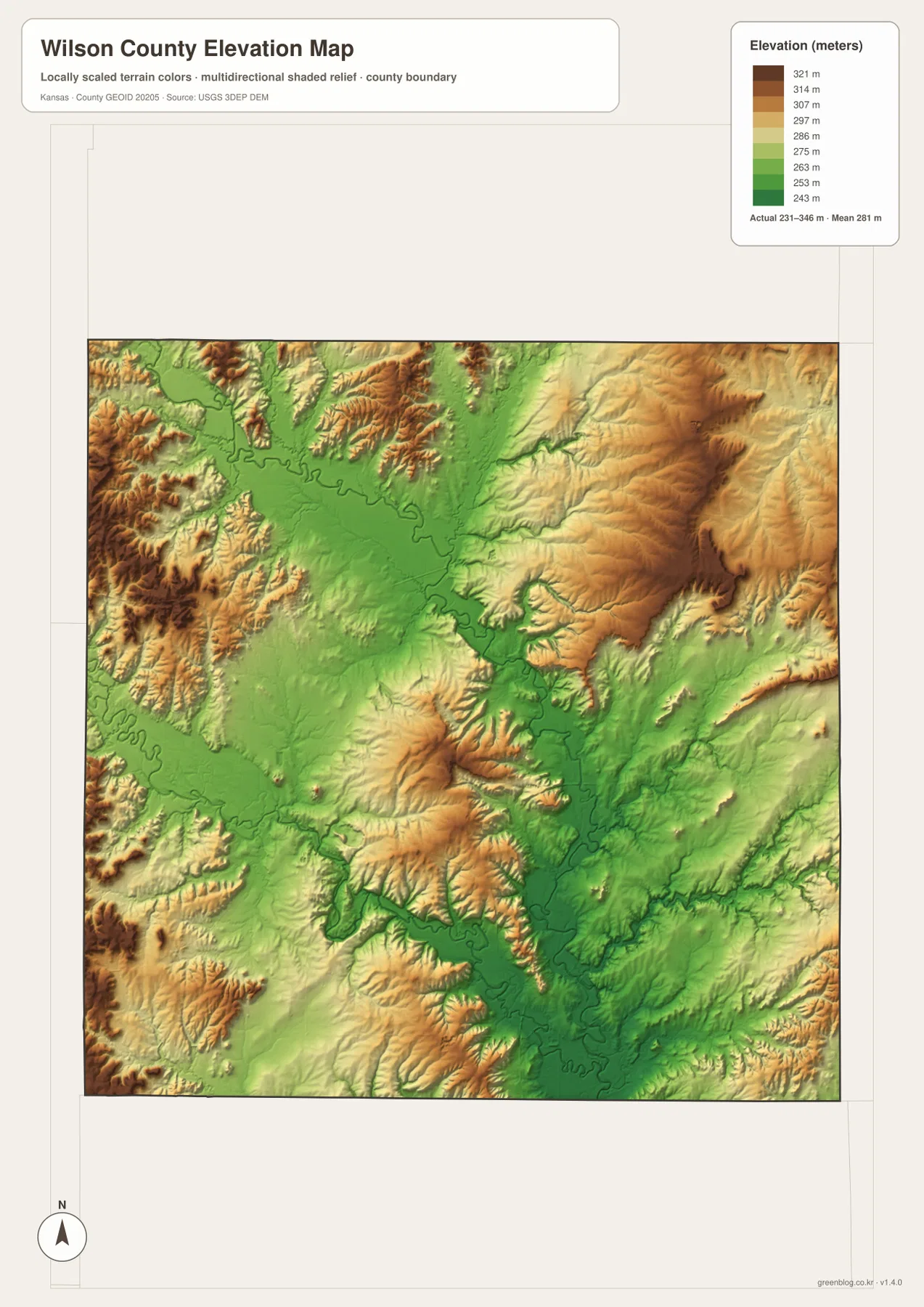
Fredonia occupies intermediate terrain cut by several smaller creeks, while Neodesha lies closer to the broad Verdigris River lowland. Big Cedar Creek in the east creates another set of low channels between more elevated ridges.
The elevation surface is generalized for county-scale comparison. It is not survey-grade or engineering-grade measurement and should not be used for parcel elevations, construction grades, drainage design, or legal boundary work.
Norman No. 1 made Neodesha a landmark in Mid-Continent oil history
The Kansas Historical Society identifies Norman No. 1 in Neodesha as the first commercially successful well in the Mid-Continent Oil Field. Oil was discovered on T. J. Norman’s property on November 28, 1892, and the well became the first west of the Mississippi River to produce oil in commercial quantity.
The discovery helped launch a much larger petroleum industry across Kansas and neighboring states. The Norman No. 1 site is now a National Historic Landmark, giving Neodesha a major industrial-history connection that is unusual for a county of this size.
Wilson State Fishing Lake gives the Buffalo area a distinctive natural reference
Kansas Department of Wildlife and Parks places Wilson State Fishing Lake about one mile south and one mile east of Buffalo. Current KDWP fishing information lists the lake at roughly 110 surface acres, making it a useful real-world landmark for the northern county.
KDWP also notes the thin soils and alternating limestone and shale around the lake. Those characteristics make the area useful for observing local geology as well as wildlife, and they fit the broken upland terrain visible around the northern part of the county.
Fredonia and Neodesha represent different sides of Wilson County
Fredonia is defined by county government and the central road network, while Neodesha is closely tied to the Verdigris River and the county’s petroleum history. The two communities are connected through the US 400 and US 75 corridors, but their physical settings and historical roles are different.
Traveling from Fredonia through Altoona toward Neodesha gradually moves from central rolling terrain into the broader river lowland. Comparing the road, water, and elevation views makes that transition much easier to see.
For posters, classroom prints, or presentation slides, use the original JPG files in the download archive rather than enlarging the web previews. Small highway shields, creek names, town labels, and the elevation legend remain clearer at the higher resolution.
Frequently Asked Questions
Which community is largest on the supplied city index?
Neodesha ranks first at 2,503. Fredonia is 1,945, Altoona 467, Buffalo 282, New Albany 88, and Coyville 62. These are map index values rather than current official population estimates.
Why is Norman No. 1 important?
Norman No. 1 in Neodesha was the first commercially successful well in the Mid-Continent Oil Field. Oil was discovered there in 1892, and the site later became a National Historic Landmark because of its importance to regional petroleum history.
Can the 231–346 meter elevation image be used for surveying?
No. It is a generalized county-scale terrain image for comparing low Verdigris and Fall River valleys with higher ridges. Parcel elevations, engineering grades, drainage design, and legal boundary work require more precise official data and, where needed, professional surveying.
Map File Information
The archive contains the Wilson County, Kansas general county map, city map, terrain-and-water map, and elevation map as original high-resolution JPG files.
- Included Files: Use only the versions confirmed in the article and supplied images
- File Type: Use the confirmed download contents
- Intended Use: Printing, education, presentations, and map-based projects
Related Maps
Sources and references
- Kansas Historical Society: Wilson County, Kansas — county-seat history, physiographic regions, and county background
- Kansas Historical Society: Norman No. 1 — Neodesha oil-well and Mid-Continent Oil Field history
- Kansas Department of Wildlife and Parks: Wilson State Fishing Lake — lake, geology, and wildlife information near Buffalo
- U.S. Census Bureau TIGER/Line Shapefiles — county boundary and geographic reference data
- USGS National Hydrography — river and stream reference data
- USGS 3D Elevation Program — elevation and terrain reference data
Green Map creates custom-edited map images using open geographic data sources such as geoBoundaries, Natural Earth, OpenStreetMap, and government open data. These maps are edited visual materials, not raw data files, and are provided for education, documents, presentations, and graphic reference.