Clay County in north-central Kansas is easiest to understand by starting at Clay Center. U.S. 24 crosses the county east to west while K-15 runs north and south, and several smaller communities sit well away from that central junction. Morganville and Clifton lie to the north, Green is east of Clay Center, Wakefield is in the southeast, and Longford and Oak Hill occupy the southwest. This page connects those places with the Republican River, its tributaries, and the county’s 347–460 meter elevation range. High-resolution JPG versions of the maps shown here are available together in the ZIP download box below.
The Republican River is the strongest natural reference line in the county. It enters from the northwest, bends through a broad low valley near the middle of the county, and continues toward the southeast. On the elevation map, that corridor appears as a wide green band below the surrounding hills. Roads, towns, creeks, and relief make more sense when read against that river valley rather than as separate layers of information.
The supplied maps emphasize different details without changing the geographic subject. The general county map combines boundaries, roads, settlements, and streams. The city map simplifies the background so the spacing of the principal communities stands out. The water and terrain map names the Republican River and many smaller creeks, while the elevation map shows how the broad river lowland sits below higher ground on both sides. The sections below follow the county itself, using Clay Center and the river as recurring reference points.
Table of Contents
Roads radiating from Clay Center
Clay Center is the most useful place to begin on the general map. U.S. 24 crosses the town from west to east, while K-15 runs north and south through the same area. Farther north, K-15 reaches K-9, and K-80 appears near Morganville. K-82 provides an important east-west reference in the southern half near Wakefield, while K-197 is marked close to the southern county line. Together these routes show a rural county in which travel is spread across several corridors rather than concentrated in one continuous urban strip.
The settlement pattern reinforces that impression. Morganville is northwest of Clay Center, Green lies to the east, and Wakefield is well to the southeast. Longford and Oak Hill are separated from the central town in the southwest, while Clifton appears close to the northern edge. Because the communities are widely spaced, the road network is particularly helpful for keeping their relative positions clear.
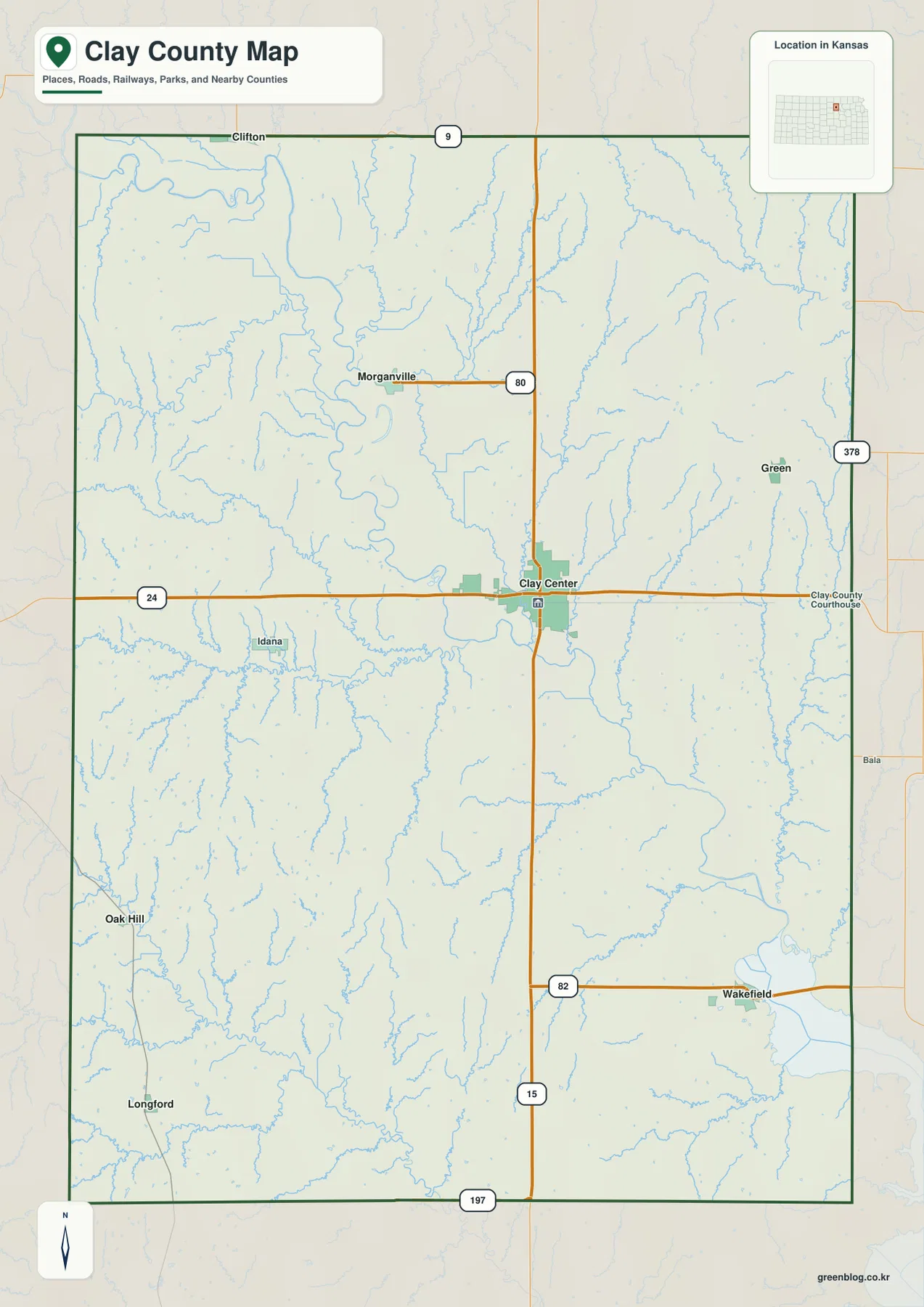
This map is best used for county-wide orientation rather than turn-by-turn navigation. Highway numbers make it easy to see which towns share a travel corridor, and the pale blue stream network provides an early hint of the landforms that become much clearer on the water and elevation maps. Current construction, closures, and road conditions should always be checked with up-to-date transportation sources before travel.
A dispersed set of towns around one central hub
The city map strips away much of the road detail and makes the distribution of the principal communities easier to compare. Clay Center occupies the middle of the county. Wakefield sits far to the southeast, Morganville is to the northwest, and Green is east-northeast of the county seat. Longford and Oak Hill form a separate southwestern group. The result is not a chain of towns along one corridor but a central hub surrounded by smaller settlements in several directions.
Rankings or population figures printed on the city map should be treated as reference information from the map’s production period, not as a substitute for current census statistics. The lasting value of this map is spatial: it shows where each named community sits inside the county. That makes it easier to return to the other maps and understand, for example, why Wakefield is associated with the lower southeastern terrain while Longford and Oak Hill sit among many smaller drainage lines in the southwest.
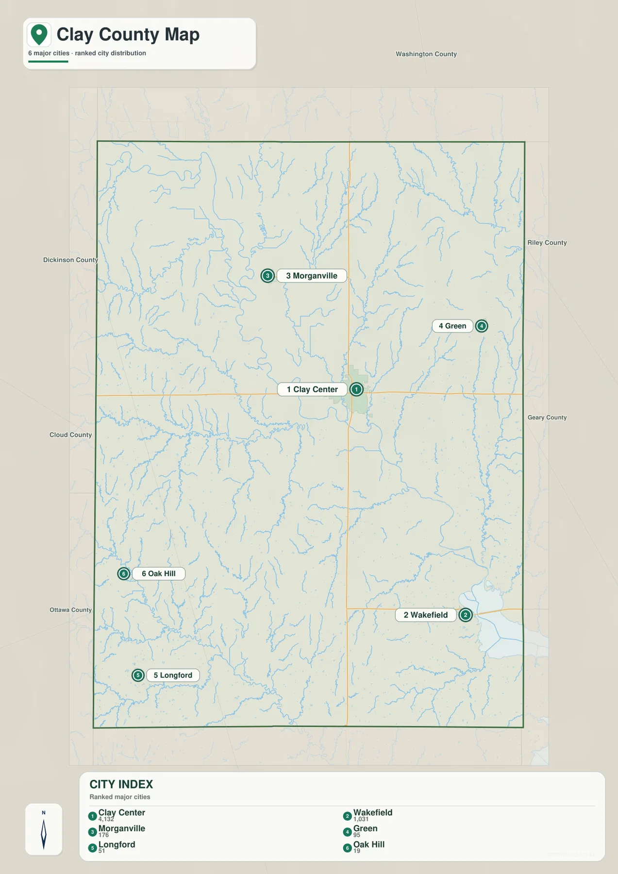
Once the town pattern is familiar, the natural geography becomes easier to follow. From Clay Center, Morganville is found to the northwest, Wakefield to the southeast, and the southwestern communities near a denser set of small creeks. Using real place names as anchors is more useful than trying to memorize the county from abstract colors alone.
The Republican River as Clay County’s central lowland
The Republican River is the dominant feature on the water and terrain map. It enters from the northwest in a series of bends, moves toward the center, and then continues east and southeast through a broad valley. Its channel is visibly larger than the surrounding tributaries, making it the clearest natural divider for organizing the rest of the drainage network.
Dry Creek and Spring Creek stand out north of the river, with West Fancy Creek farther northeast. North Branch Five Creek and Five Creek approach from the west. East of the central valley, Lincoln Creek, West Branch Mill Creek, and Mill Creek form another recognizable group. The southern half includes Otter Creek, Cane Creek, Chapman Creek, Quimby Creek, and Badger Creek. These names show how finely the uplands are divided by small valleys even where there is no large river nearby.
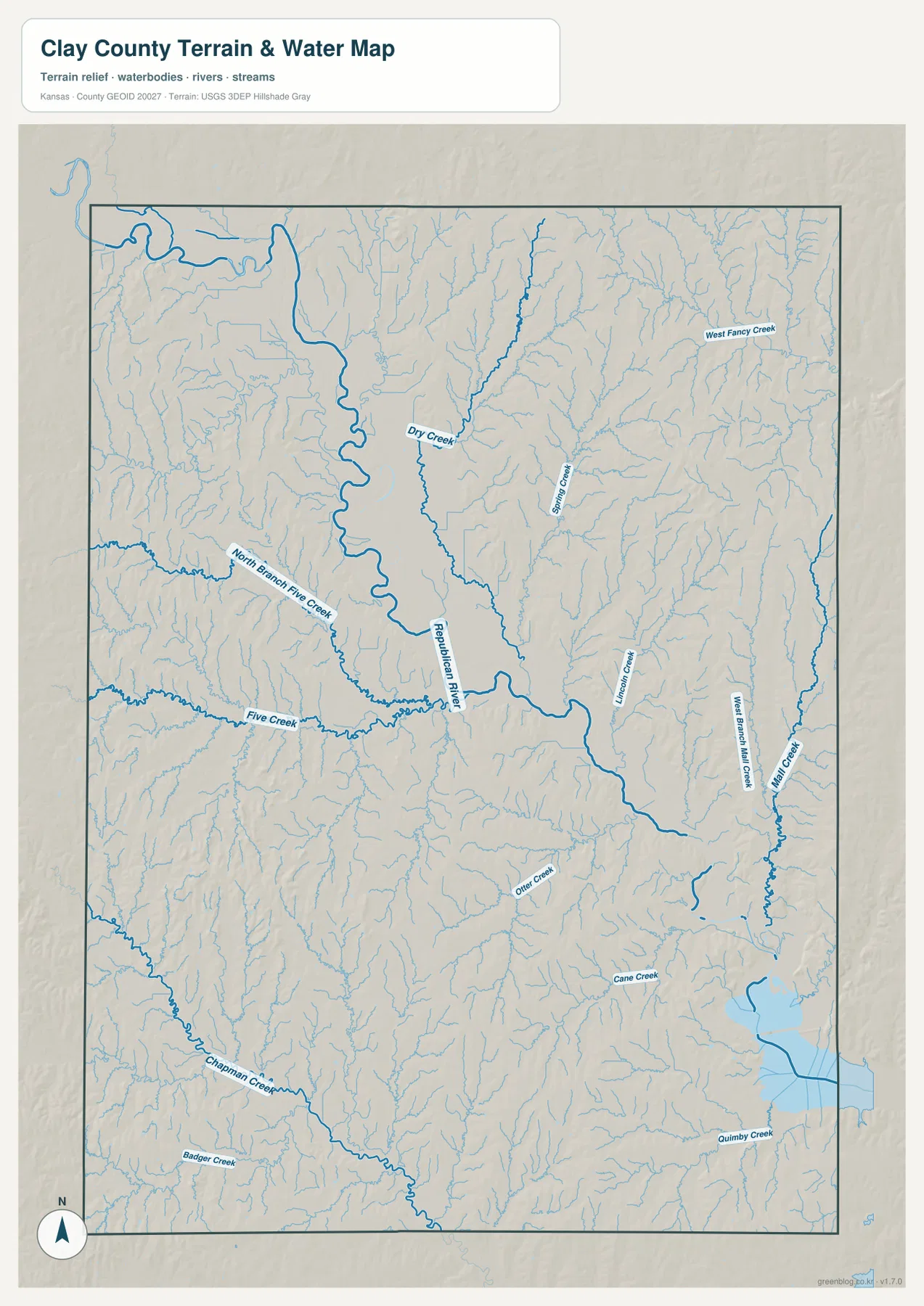
The water map is a geographic reference, not a live flood or navigation product. Flow conditions can change with season and rainfall, and small streams may look very different on the ground from one period to another. Its main value here is showing where the named valleys lie and how they connect to the Republican River or to drainage systems farther south and east.
A 347–460 meter relief pattern centered on the river valley
The elevation map gives an actual county range of about 347 to 460 meters, with a mean near 392 meters. The broad green corridor of the Republican River is the most obvious low area. It sweeps from the northwest toward the center and southeast, widening in places where the river meanders across a broader floor. This low band provides a strong visual contrast with the higher ridges on both sides.
Higher orange and brown ground is widespread to the northeast and southwest. Those areas are not uniform plateaus; shaded relief reveals many short ridges and tributary valleys cutting into them. In the south, Chapman Creek and other drainage lines create narrow lower corridors inside otherwise higher terrain. The pattern closely matches the dense stream network on the water map and makes clear that Clay County is more rolling than a simple flat-plains description would suggest.
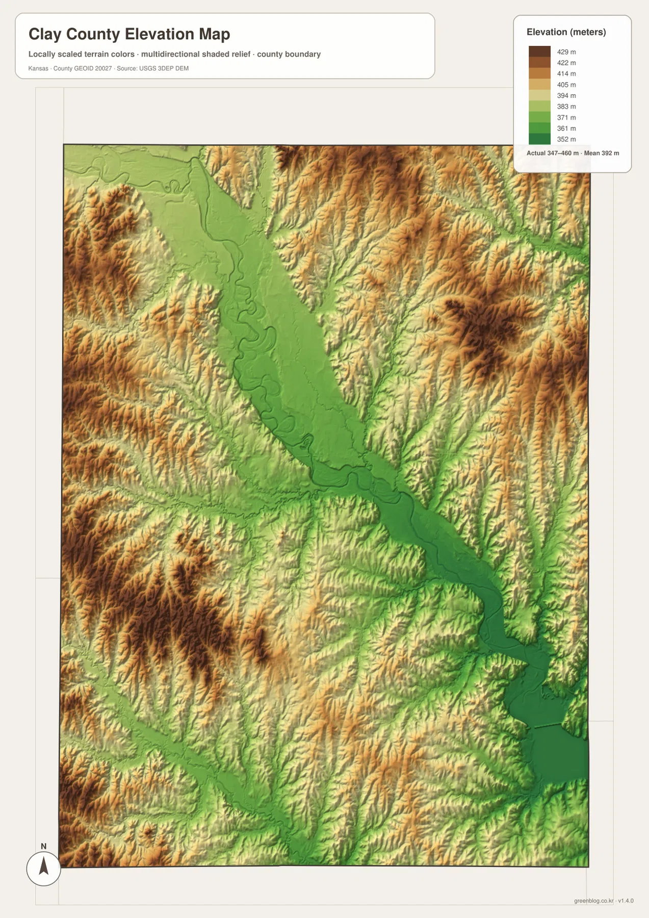
This is a county-scale elevation reference rather than survey-grade measurement for individual parcels. The colors and shaded relief are designed to make broad landform differences easy to see. Engineering, construction, drainage design, or precise point elevations require detailed source data or field surveying. For general map reading, however, the contrast between the central river lowland and the higher outer parts of the county is immediately useful.
Following one place across roads, water, and relief
Clay Center works well as a cross-map anchor. On the general map, find the U.S. 24 and K-15 junction. On the water map, the Republican River valley is close by, and on the elevation map the same area appears in the lower green corridor. This sequence shows how transportation, settlement, and topography occupy the same landscape rather than functioning as unrelated map themes.
Wakefield offers a different comparison. It lies in the southeast near a broader low area where water becomes visually prominent at the county edge. Moving back toward Green or Morganville takes the eye away from that low corridor and into more dissected uplands. Longford and Oak Hill provide another contrast: their southwestern setting is organized less by the main river and more by smaller creek valleys and rolling ridges.
This approach is especially useful when printing the maps. Mark one town, identify the nearest major road, then trace the closest named creek or river and compare the same location on the elevation sheet. A few fixed reference points make a large rural county much easier to understand than reading every label at once.
Choosing the most useful map for the task
Use the general county map when boundaries, highways, communities, and streams need to appear together. The city map is better when the goal is to compare the placement of Clay Center, Wakefield, Morganville, Green, Longford, and Oak Hill without extra road detail. The water and terrain map is the strongest choice for named creeks and drainage relationships, while the elevation map is most useful for comparing the Republican River lowland with higher surrounding ground.
For classroom materials, reports, presentations, or larger-format printing, the downloadable high-resolution JPG files provide more detail than the web previews. They remain reference maps rather than live navigation, flood-warning, legal-boundary, or engineering products. Anyone needing current road status, current stream conditions, parcel boundaries, or precise elevations should pair these maps with the latest authoritative source for that purpose.
Frequently Asked Questions
Why is Clay Center the easiest reference point on these maps?
Clay Center sits near the middle of the county where U.S. 24 and K-15 meet, so it provides a simple anchor for locating the other communities. It is also close to the Republican River valley, which makes the town useful for connecting roads, settlement, drainage, and elevation across the different maps.
Why does the Republican River corridor appear lower on the elevation map?
The river occupies a broad valley that is lower than the surrounding rolling uplands. On the elevation map, this appears as a green corridor, while higher ridges on both sides are shown in warmer colors. The map is appropriate for broad terrain comparison but not for precise parcel-level elevation work.
Are the city-map rankings current population figures?
They should be treated as reference information from the map’s production period. For current population statistics, consult the latest U.S. Census Bureau data. The city map is most useful here for comparing where the principal communities are located within Clay County.
Map File Information
Download the high-resolution source maps corresponding to the Clay County maps shown on this page.
- File Type: High-resolution JPG
Related Maps
Sources and References
- U.S. Census Bureau TIGER/Line Shapefiles – boundary, road, and geographic reference data
- USGS National Hydrography – river and stream reference data
- USGS 3D Elevation Program – elevation and terrain reference data
Green Map creates custom-edited map images using open geographic data sources such as geoBoundaries, Natural Earth, OpenStreetMap, and government open data.
These maps are edited visual materials, not raw data files, and are provided for education, documents, presentations, and graphic reference.