You can download high-resolution JPG maps of Fayette County, Illinois directly from this page. The county covers a broad part of south-central Illinois, with Vandalia near the middle of the main county body and Ramsey, St. Elmo, Farina, and other communities spread in very different directions. The maps below connect the county boundary and major roads with town locations, the Kaskaskia River system, and the change from low river corridors to higher rolling ground.
The county government lists Fayette County at about 716 square miles. Its outline is not a simple rectangle: a narrow section drops toward the southwest, while a much longer extension reaches southeast toward St. Peter and Farina. Vandalia works well as an orientation point because US 51 runs north toward Ramsey and US 40, together with Interstate 70, crosses the central part of the county toward Brownstown and St. Elmo.
The four downloadable JPG files are 2572 × 3638 pixels each and cover the same subjects as the body maps: the general county view, the city distribution, terrain and water, and elevation. The larger files are useful when you need to print a map, enlarge road and stream labels, or place several views side by side. For ordinary browsing, the sections below explain what each map contributes without treating the county as a list of separate layers.
Table of Contents
Vandalia is the clearest anchor for roads and the county outline
The general county map places Vandalia slightly west of the center of the main county body and marks the courthouse there. Ramsey sits well to the north, Brownstown and St. Elmo lie to the east, and St. Peter and Farina occupy the long southeastern extension. Bingham appears toward the northwest. That spread matters because Fayette County cannot be understood as one compact group of towns surrounding the county seat; the map makes the distance and direction between its separate areas much easier to judge.
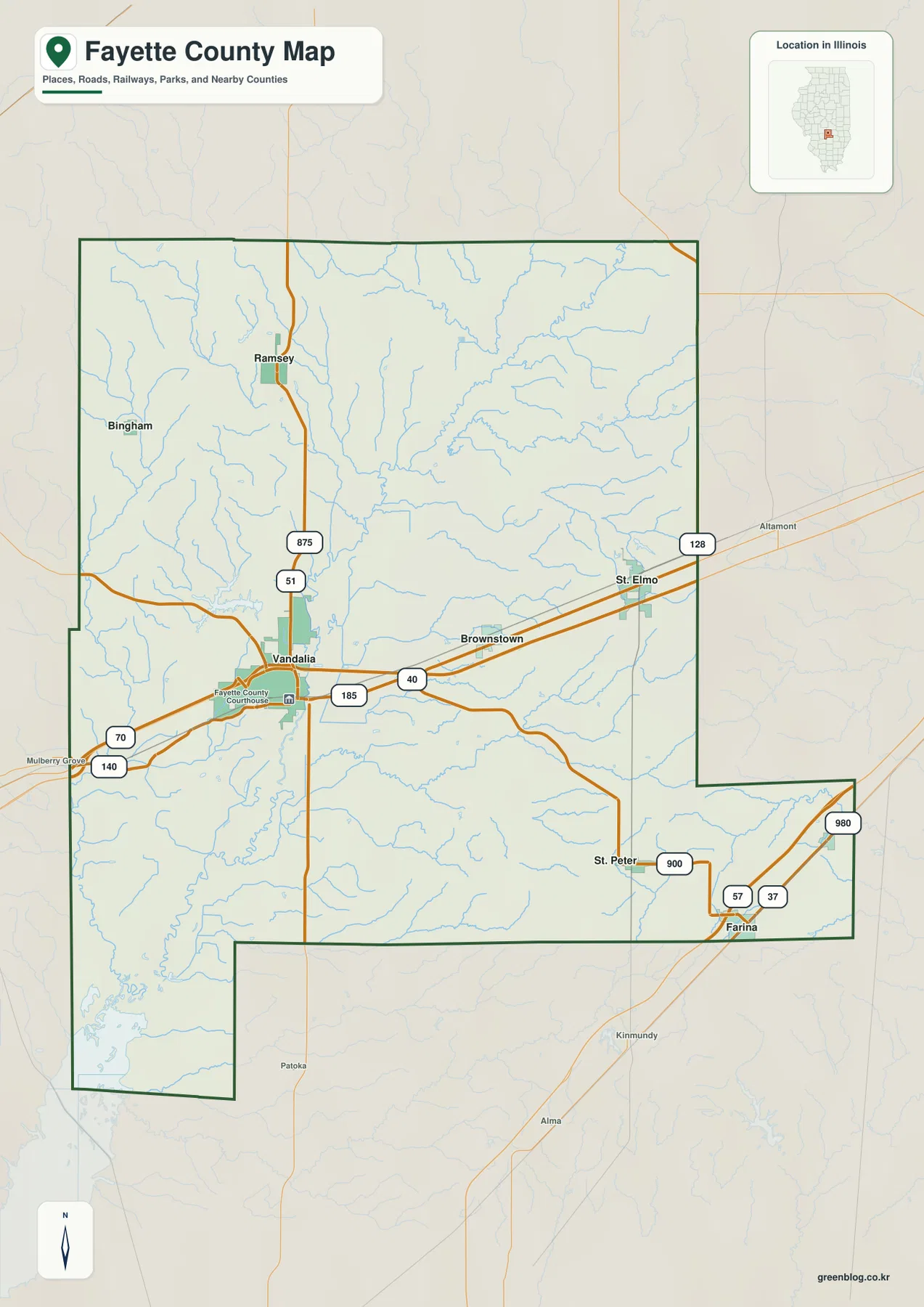
US 51 is the strongest north-south reference between Vandalia and Ramsey. US 40 runs east from Vandalia toward Brownstown and St. Elmo, while Interstate 70 crosses the same central portion of the county as the principal long-distance route. Beyond those corridors, a large local road network serves rural areas; the Fayette County Highway Department reports responsibility for about 167 miles of county highway and 51 bridges. The map therefore works best when the major highways are used as reference lines rather than as the only roads that matter.
The boundary is also worth tracing before moving to the other maps. A narrow southwestern section reaches down toward the Clinton County side, while the southeastern arm extends between neighboring areas toward Farina and St. Peter. Labels for Montgomery, Marion, Clinton, Bond, Shelby, Effingham, and Clay counties provide a regional frame. They show why the county’s eastern and southern communities can look farther apart on a road map than a quick glance at the county name alone might suggest.
Ramsey and Farina show how widely the settlement pattern spreads
The city map removes much of the secondary detail and emphasizes six communities: Vandalia, St. Elmo, Ramsey, Brownstown, Farina, and St. Peter. Vandalia is ranked first on the supplied city index, but the more useful information is the distribution on the page. Vandalia, Brownstown, and St. Elmo form a broad central east-west group, Ramsey stands apart in the north, and Farina with St. Peter identifies the southeastern extension.
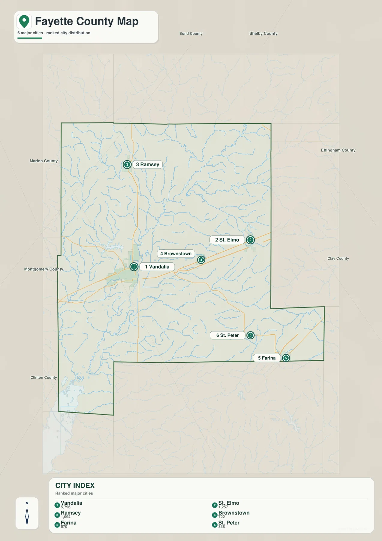
When this view is compared with the road map, the pattern becomes more meaningful. Ramsey lines up with the US 51 corridor north of Vandalia, while Brownstown and St. Elmo follow the broad eastward direction of US 40 and Interstate 70. Farina and St. Peter belong to a different part of the county in the southeastern arm, so they should not be pictured as part of the same compact central cluster. The city map is especially useful for that simple directional comparison before more detailed roads are added back in.
Vandalia also has historical importance beyond its current role as the county seat. Illinois historic-preservation records identify the surviving Vandalia State House as the capitol used from 1836 to 1839, during the period when Vandalia served as Illinois’s state capital before Springfield. That history helps explain why Vandalia remains the most recognizable place in the county even though the modern settlement pattern extends far beyond it.
The Kaskaskia River links lakes, creeks, and the county’s lower ground
The terrain-and-water map shifts attention away from highways and toward the Kaskaskia River. It enters from the north, follows a broad path through the central part of Fayette County, and continues south while receiving many smaller streams. Once the river is located, the elevation map becomes easier to understand because much of the lowest terrain follows the same central corridor rather than forming a simple north-south or east-west slope.
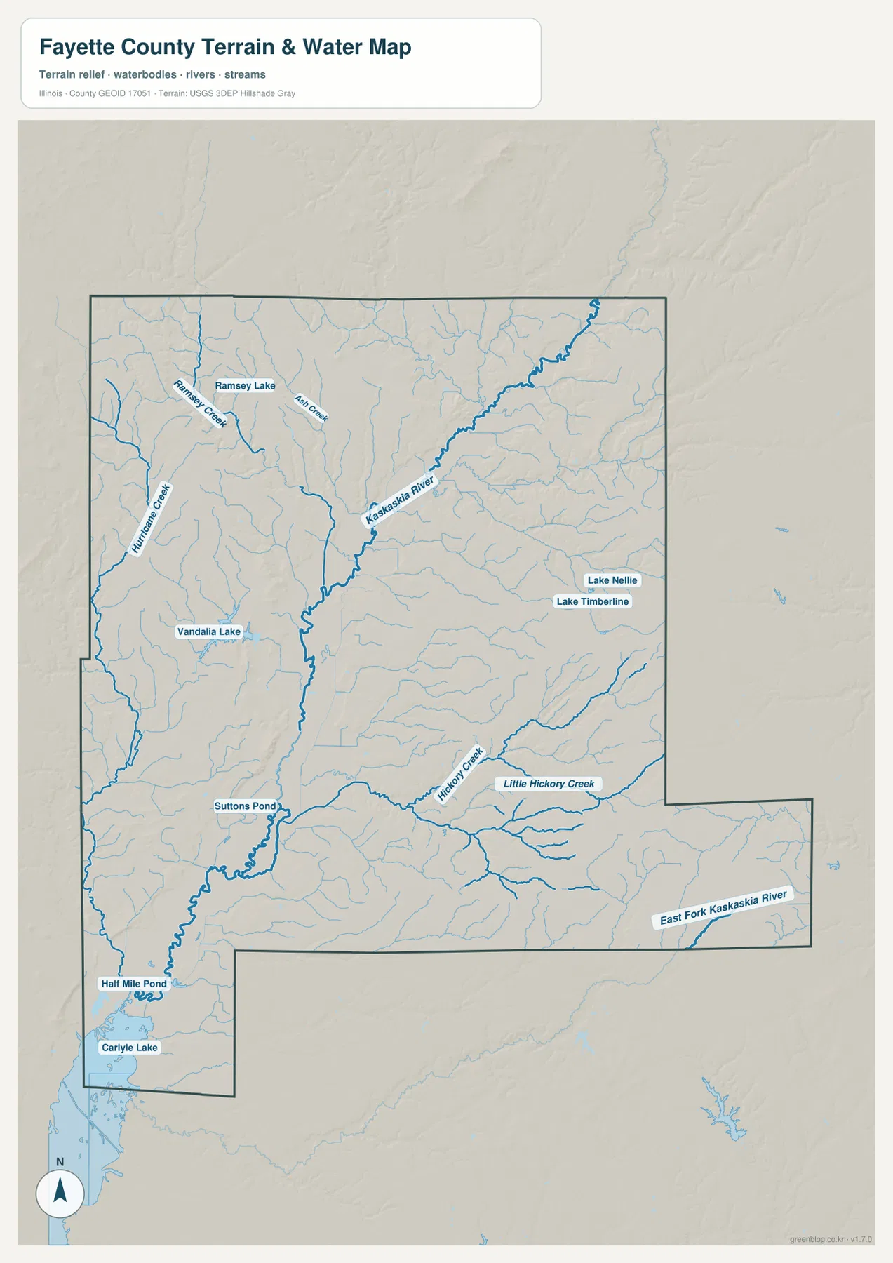
Ramsey Creek and Ramsey Lake appear in the northwest, with Akin Creek farther east. Hurricane Creek runs near the western side, and Vandalia Lake is labeled near Vandalia. Lake Nellie and Lake Timberline appear toward the eastern side, while Suttons Pond lies farther south. In the southeastern arm, Hickory Creek and Little Hickory Creek form a separate branching group, and the East Fork Kaskaskia River appears near the far southeast edge. The number of named tributaries makes it clear that the county’s drainage is spread through many valleys even though the Kaskaskia is the dominant river.
Ramsey Lake also connects the map to a real recreation area. The Illinois Department of Natural Resources describes Ramsey Lake State Recreation Area northwest of Ramsey, in a landscape of rolling ground, woodland, and water. Seeing the town and lake in the same part of the county adds useful local context that is not obvious from a highway-only view. The water map, however, is a location reference rather than a flood, depth, legal-boundary, or navigation product.
A 135–218 meter range reveals rolling relief around the river corridor
The supplied elevation map gives an actual county range of roughly 135 to 218 meters, with a mean near 169 meters. The lowest green tones occupy much of the Kaskaskia River corridor and the southwest, while warmer tan and brown colors appear more often in the northwest and across parts of the east. Fayette County does not have dramatic mountain terrain, but the map shows repeated differences between creek bottoms, river lowlands, and the rolling higher ground between them.
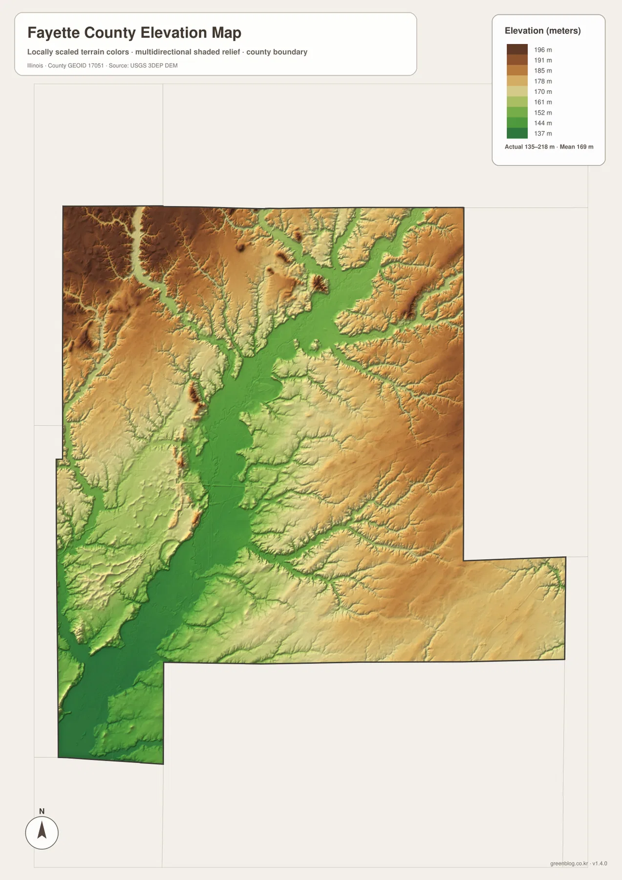
The strongest relationship appears in the middle of the county, where the low green band follows the Kaskaskia River. Smaller low lines branch outward along tributaries, leaving higher ground between neighboring stream valleys. Around Ramsey, short changes between creek bottoms and higher interfluves are visible, and similar patterns appear east and southeast of the central river. This repeated valley-and-upland pattern is more accurate than describing the county as simply higher on one side and lower on the other.
Use this elevation image for broad comparison rather than survey-grade measurement. It is useful for seeing which parts of the county are relatively low or high and for explaining why the major waterways occupy particular valleys. Construction, drainage design, property work, and other technical decisions require more detailed elevation data or a professional survey, so the colors on this map should not be treated as precise site-level measurements.
Choose the map by the feature you need to locate
For first-time orientation, start with the general county map. Find Vandalia, trace US 51 north toward Ramsey, then follow US 40 and Interstate 70 east toward Brownstown and St. Elmo. Once those directions are established, the southeastern extension toward St. Peter and Farina is easier to place, and the neighboring county labels give the full outline a regional context.
The city map is quicker when the main question is simply how the six principal communities are distributed. If you are looking for a river, lake, or creek, use the terrain-and-water map and follow the Kaskaskia through the center before moving to Ramsey Lake in the northwest or the Hickory Creek system in the southeast. Add the elevation map when you want to see how those waterways occupy lower ground between higher rolling areas.
The WebP images are convenient for browsing, but the JPG archive below is better for printing, enlarged labels, and side-by-side comparison. The four files contain the same geographic subjects at 2572 × 3638 pixels each. They are general reference maps, so legal boundary confirmation, flood analysis, surveying, engineering, or other technical work should use the latest specialized data from the responsible agencies.
Frequently Asked Questions
Which roads are the easiest references for Ramsey, Vandalia, and St. Elmo?
Use Vandalia as the starting point. US 51 provides the clearest north-south reference toward Ramsey, while US 40 and Interstate 70 establish the eastward direction toward Brownstown and St. Elmo. Looking at the city map first and then returning to the general road map is a quick way to connect the town positions with the actual travel corridors.
Can Ramsey Lake and the Kaskaskia River be compared on one map?
Yes. The terrain-and-water map shows Ramsey Lake in the northwest and the Kaskaskia River running through the central part of the county. It also labels Vandalia Lake, Hurricane Creek, Lake Nellie, Lake Timberline, Hickory Creek, Little Hickory Creek, and the East Fork Kaskaskia River. The map is intended to compare locations, not to determine flood zones, water depth, or navigation conditions.
Which view shows the unusual southwest and southeast parts of the county most clearly?
The general county map is the best choice because it keeps the full outline in one frame. The narrow southwestern section and the much longer southeastern projection toward St. Peter and Farina are both visible, and the neighboring county labels help explain where those extensions fit within south-central Illinois.
Map File Information
The download archive contains the full-size JPG versions of the Fayette County general map, city map, terrain-and-water map, and elevation map. Use the WebP images for quick online viewing, then download the larger files when you need printing, enlarged labels, or a local reference copy.
- Printable Size: 2572 × 3638 pixels for each JPG
- File Type: ZIP containing four JPG files
Related Maps
Sources and references
- Fayette County, Illinois – Communities & Fast Facts: county seat, area, and community information
- Fayette County Highway Department: county highway and bridge information
- Illinois DNR – Ramsey Lake State Recreation Area: location and landscape around Ramsey Lake
- Illinois DNR Historic Preservation – Vandalia State House: Vandalia’s state-capital history
- USGS National Hydrography: national hydrography reference data
- USGS 3D Elevation Program: elevation data reference
Green Map creates custom-edited map images using open geographic data sources such as geoBoundaries, Natural Earth, OpenStreetMap, and government open data.
These maps are edited visual materials, not raw data files, and are provided for education, documents, presentations, and graphic reference.