Goliad County sits in South Texas with the town of Goliad near the center of a road network crossed by the San Antonio River and many smaller creeks. This page provides a Goliad County Map set for several kinds of reference work: one map emphasizes the county boundary and roads, another isolates the main city, a water map traces the river and tributaries, and an elevation map shows the rise toward the western side of the county. An A3 high-resolution JPG ZIP is also available in the download box later on the page, so the maps can be used beyond the on-screen WebP previews.
The maps are most useful when read together. US 59 passes through Goliad from west to east, while US 77 Alternate runs north-south through the same area. The water layer shows the San Antonio River crossing the middle of the county and receiving creeks from both the north and south. The elevation layer adds another piece of the picture: the west and northwest are higher and more strongly textured, while the eastern and southeastern sections are lower. That combination makes Goliad County a good example of how roads, settlement, drainage, and gentle relief can be compared within one county boundary.
Table of Contents
Start with Goliad and the main road junction
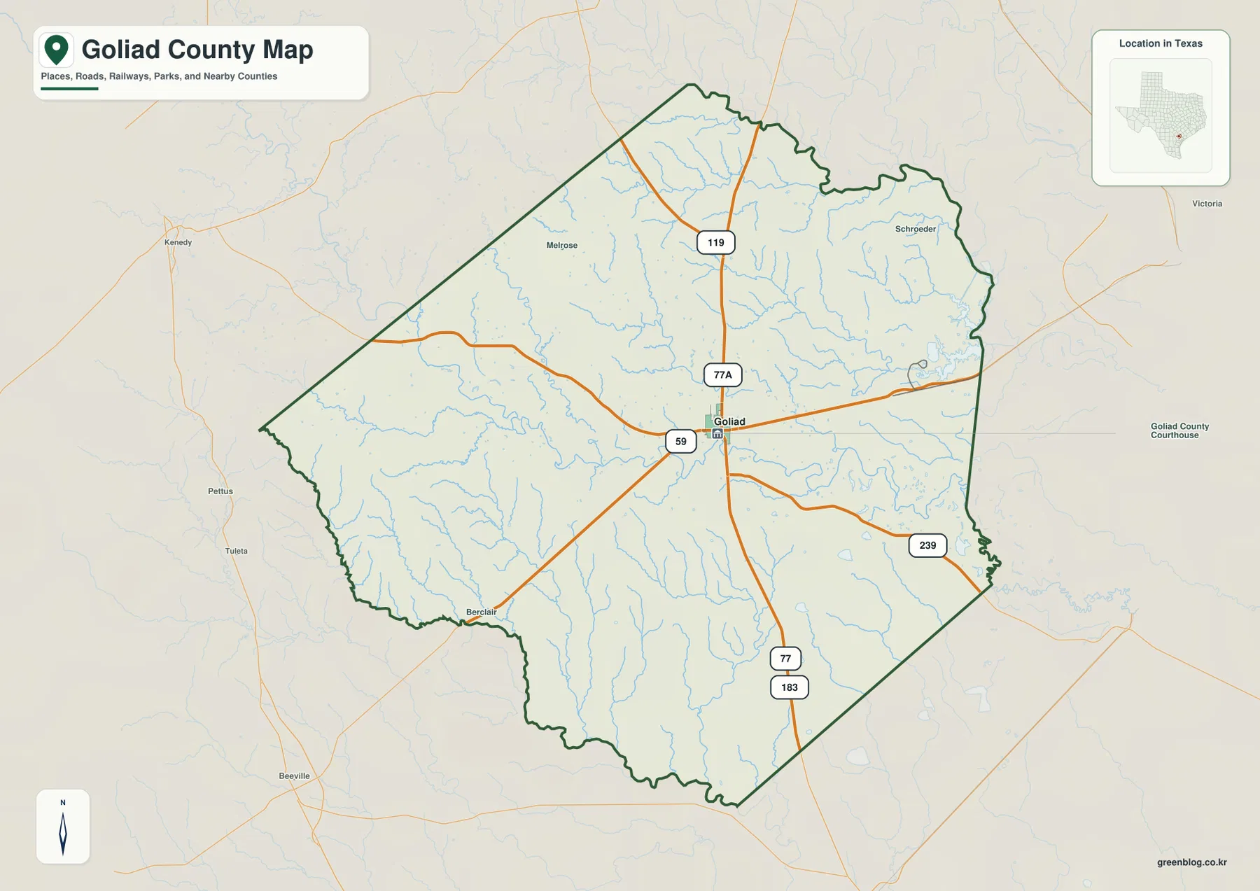
Goliad is the county seat and the clearest place label on the general county map. It lies close to the middle of the mapped area, which makes it a useful starting point for orientation. US 59 enters from the west, passes through Goliad, and continues toward Victoria County. US 77 Alternate approaches from the north and continues through the town, while the map also shows Highway 119 farther north, Highway 239 running southeast, and US 77 and US 183 sharing the principal southbound corridor.
Once those roads are located, the smaller place names become easier to place. Melrose appears northwest of Goliad, Schroeder is in the northeastern part of the county, and Berclair is marked in the southwest. These communities do not carry the same visual weight as the county seat, but they are useful reference points across a largely rural map. The pattern is not one continuous built-up area; instead, a central town and a handful of smaller named places are separated by broad stretches with fewer labels.
The inset on the general map places the county within Texas, while the outer background helps show its relationship to surrounding counties. Goliad County borders Bee, Karnes, DeWitt, Victoria, and Refugio counties. For a quick location explanation, it is usually enough to identify Goliad first, trace US 59 toward Victoria, and then use the north-south highway line to understand how the county connects with the rest of South Texas.
Why the city index looks much simpler than the county map
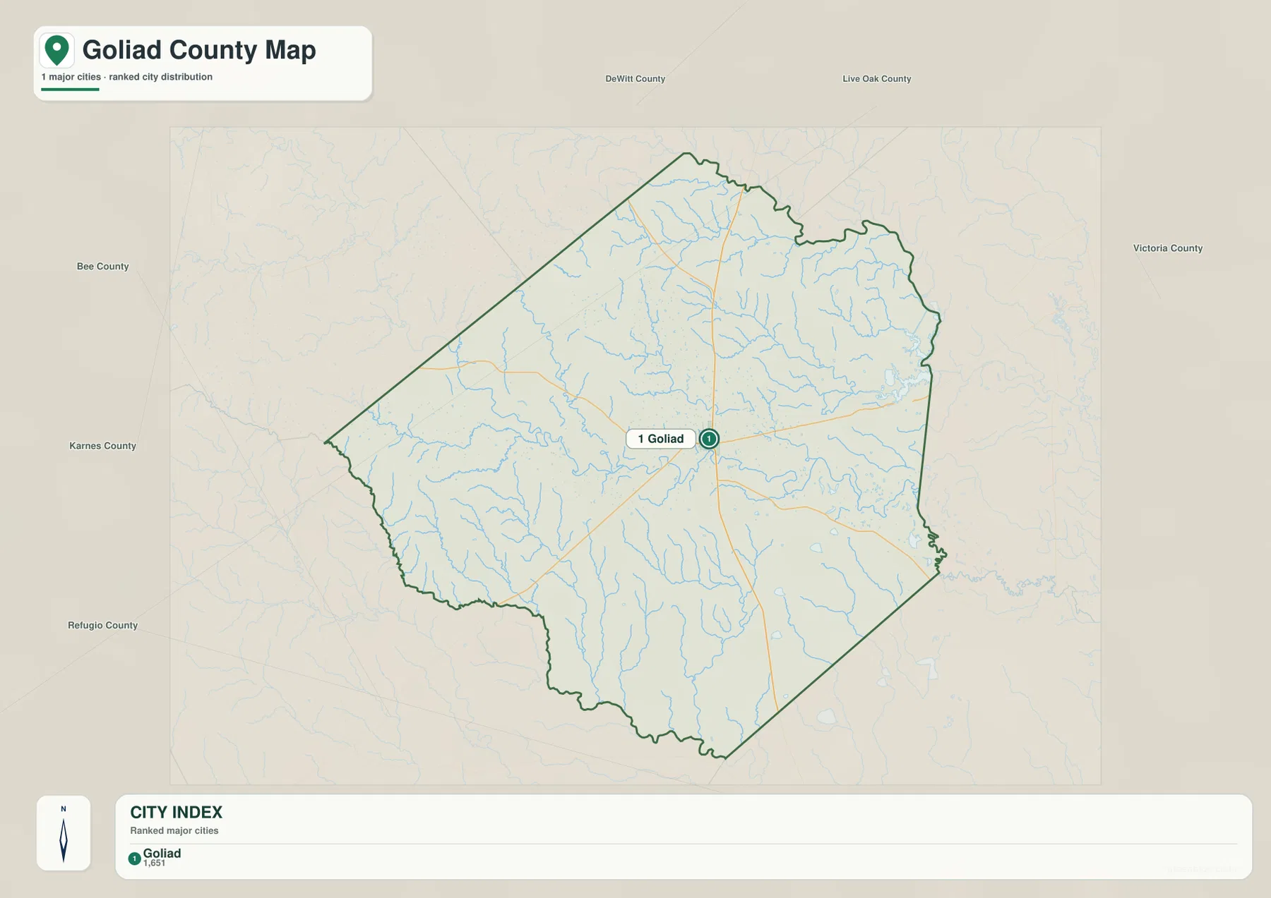
The city map intentionally strips away much of the settlement detail and ranks Goliad as the major city in the county. That is a noticeable contrast with the general map, where several smaller communities are labeled. The simpler city view is useful when a reader only needs to answer a basic question such as where the county’s principal town sits within the boundary. Goliad appears near the center, and the thin road and stream background still gives enough context to connect it to the rest of the county.
This sparse city pattern also reflects the way the county is organized on the map. Goliad holds the administrative role and is the obvious urban reference point, while smaller communities are more dispersed. For a presentation slide, a location diagram, or a quick county profile, the city map avoids the extra labels that can make a small image hard to read. For local navigation or a more detailed geographic description, the general county map remains the better choice because it retains the road numbers and additional place names.
The San Antonio River is the clearest water feature
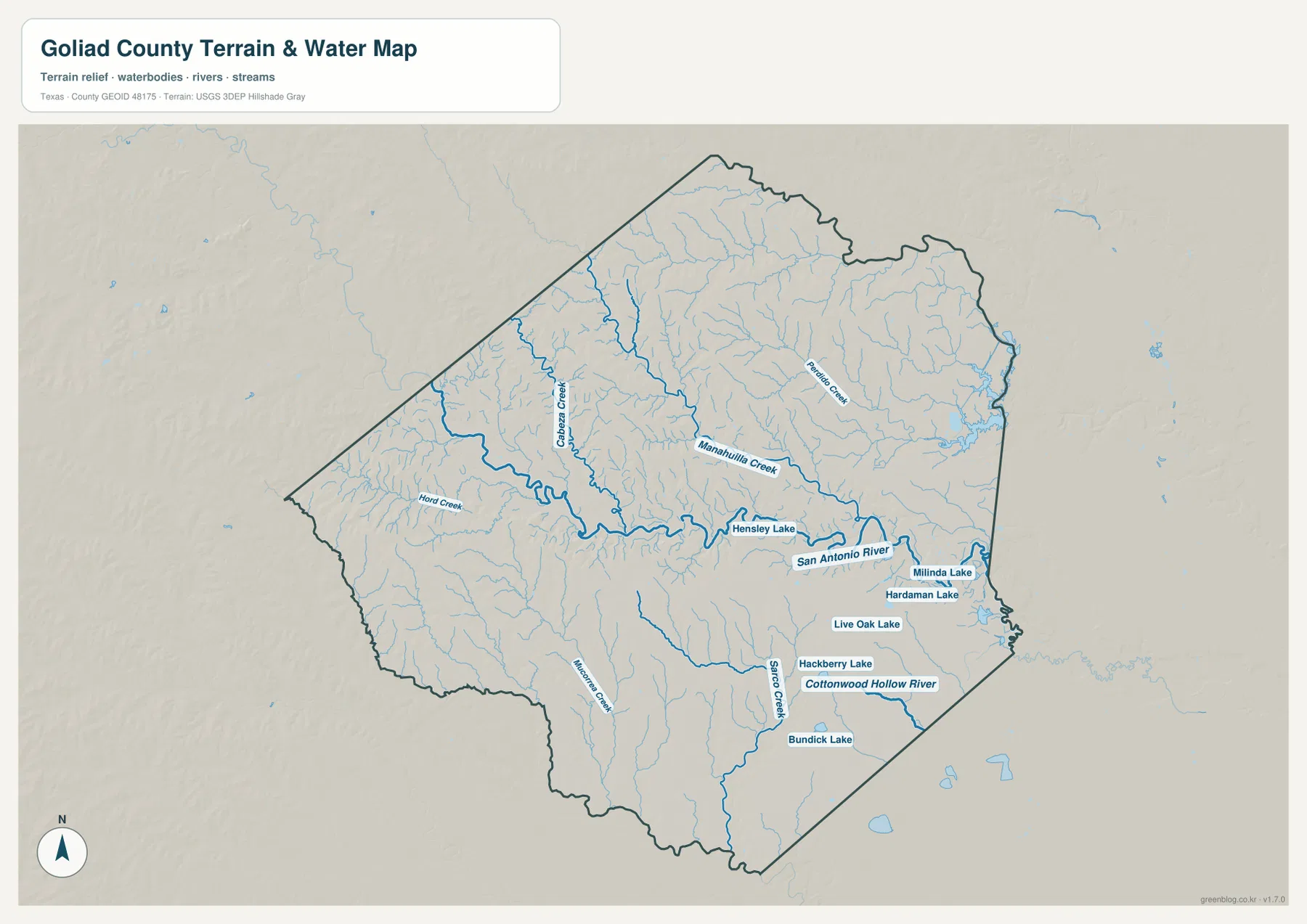
On the terrain and water map, the San Antonio River is the most prominent named waterway. It crosses the central part of the county and continues eastward, with a network of tributaries feeding into it from both sides. Cabeza Creek approaches from the northwestern side, Manahuilla Creek runs through the north-central area, and Perdido Creek is labeled farther northeast. Hord Creek is marked toward the west, while Mocorrera Creek and Sarco Creek help define drainage in the southern half.
The many thin blue lines matter as much as the larger river when the map is viewed at full size. They show that the county is cut by numerous small drainage channels rather than by one isolated river corridor. In the northern half, several branches descend from higher ground toward the central drainage. South of Goliad, smaller streams also trend toward lower areas and eventually connect with larger waterways. This makes the water map useful for explaining the shape of the terrain without turning the page into a technical hydrology report.
Several small named lakes are visible as well, including Hensley Lake near the San Antonio River corridor and Milinda, Hardaman, Live Oak, Hackberry, and Bundick lakes farther east or south. Their presence is useful for local reference, although the map does not indicate public access, recreation rules, ownership, or current water conditions. Anyone planning a visit should treat the map as a location reference and check the relevant land manager or local agency for current access information.
Elevation rises toward the west and northwest
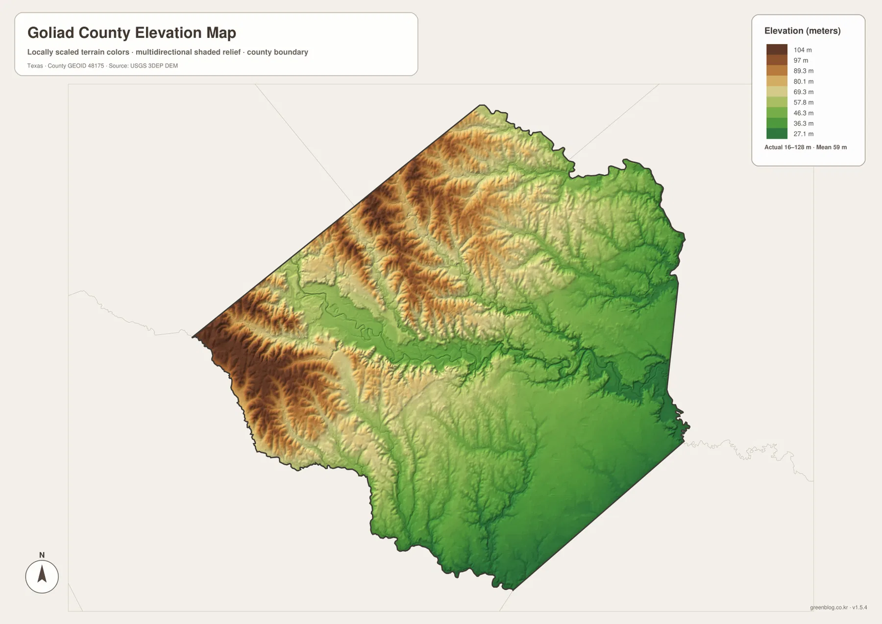
The elevation map gives Goliad County a very different appearance from the road map. Its displayed actual range is about 16 to 128 meters, with a mean of about 59 meters. Browns and tan shades cluster across the western and northwestern portions, while broad green areas dominate the east and southeast. The county is not mountainous, but the shaded relief reveals a large number of low ridges and shallow valleys that are easy to miss on a flat reference map.
A lower corridor is also visible through the central and eastern part of the county. When the elevation and water maps are compared, that lower ground lines up with the San Antonio River and adjoining drainage. Small tributaries cut into the higher western terrain before joining the lower river system. This visual relationship is useful in a classroom or regional geography project because it shows why the blue drainage lines are not randomly distributed across the county.
The strongest relief appears along the western side, where closely spaced shaded ridges create more texture. Moving eastward, the surface becomes lower and smoother overall, even though local creek valleys remain visible. The map should not be used by itself for flood-zone, engineering, or property decisions, but it is a clear reference for comparing relative height across the county and for explaining the broad west-to-east decline in terrain.
Five neighboring counties frame Goliad County
Goliad County shares borders with Bee County, Karnes County, DeWitt County, Victoria County, and Refugio County. Those neighbors help explain the directions of the main highways. The US 59 corridor points toward Victoria to the east, while other roads leave Goliad toward the north, south, and west. A county boundary is useful for administrative reference, but roads and rivers continue beyond it, so a regional map is often the better companion when the goal is travel planning or a broader geographic comparison.
The San Antonio River provides an especially strong regional connection. The river reaches Goliad County after flowing southeast through other parts of Texas and continues beyond the county toward the coastal plain. Historically, the river was also central to the Spanish mission and presidio sites around Goliad. Today, Goliad State Park & Historic Site sits along the river and preserves Mission Espíritu Santo, which gives the waterway a cultural importance that is not obvious from a simple blue line on the map.
For map comparison, Victoria and Refugio are useful neighbors on the eastern and southeastern side, while DeWitt, Karnes, and Bee help place the inland side of the county. Looking at adjacent counties at the same scale can clarify where major roads continue and how the San Antonio River fits into a larger drainage system. The related-map block later on the page provides internal links without changing the fixed county identity or permalink of this post.
Choose the file that matches the question you need to answer
The general county map is the most versatile option for finding Goliad, road numbers, smaller communities, streams, and the outer boundary in one view. The city map is cleaner when the main purpose is to show the location of Goliad without many competing labels. The terrain and water map is the best of the set for tracing the San Antonio River, tributary creeks, and small lakes. The elevation map is the better choice when relative height, ridges, valleys, or the west-to-east terrain change matters more than road names.
The downloadable archive contains four A3 high-resolution JPG files corresponding to those four map types. They can be used for printing, classroom handouts, reference sheets, or image editing where the smaller WebP preview is not sufficient. Because each map emphasizes a different layer, using two maps side by side is often more informative than trying to force every detail into one image.
Useful ways to combine the maps
For a trip centered on Goliad, begin with the county map to find US 59 and US 77 Alternate, then use the water map to see how close the town is to the San Antonio River. That sequence gives a better county-scale picture before switching to current turn-by-turn navigation. For a visit to Goliad State Park & Historic Site or nearby historic locations, the maps help explain the setting, but opening hours, road closures, and site access should always be checked with the current official source.
In a geography lesson, students can mark Goliad and the main highways on the general map, identify tributaries on the water map, and then compare those lines with the lower green areas on the elevation map. The exercise shows how drainage follows terrain without requiring specialized GIS software. It also makes the western ridges and the lower eastern half easier to describe with evidence from the maps rather than with a generic statement about South Texas.
For a report or printed reference sheet, the city map works well as a small locator figure, while the general or water map can carry the detailed explanation. If the project focuses on the physical landscape, pairing the water and elevation maps gives the strongest comparison. The downloadable JPG set makes it possible to select only the relevant map or to keep all four at a consistent size for a multi-page document.
Frequently Asked Questions
Which roads should I locate first on a Goliad County map?
Start with US 59 through Goliad and US 77 Alternate running north-south. After those are clear, add Highway 119 to the north, Highway 239 to the southeast, and the US 77/US 183 corridor south of Goliad to understand the main directions of travel.
Where is the San Antonio River on the county map set?
It is most clearly labeled on the terrain and water map, where it crosses the central part of Goliad County and continues eastward. Several creeks feed into it, and the elevation map shows that much of the river corridor occupies lower ground than the higher western side of the county.
What is included in the downloadable Goliad County map ZIP?
The archive contains four A3 high-resolution JPG files: a general county map, a city map, a terrain and water map, and an elevation map. Choose the county map for roads and boundaries, the water map for rivers and creeks, and the elevation map for relative height and terrain shape.
Sources and reference data
Boundary and base geography can be checked with the U.S. Census Bureau TIGER/Line Shapefiles. Water features and drainage data are available from USGS National Hydrography, while elevation source data can be reviewed through the USGS 3D Elevation Program.
For county-specific background, the Handbook of Texas entry for Goliad County summarizes the county’s setting, drainage, neighboring counties, and history. The Texas Parks & Wildlife Department page for Goliad State Park & Historic Site provides current information about the park, Mission Espíritu Santo, and activities along the San Antonio River. Check current agency notices when the maps are being used for an actual visit.
Map File Information
The ZIP contains A3 high-resolution JPG versions of the county, city, water, and elevation maps for Goliad County.
- File Type: JPG
Related Maps
- Refugio County Texas map
- Victoria County Texas map
- San Patricio County Texas map
- Atascosa County Texas map
- Wilson County Texas map
Green Map creates custom-edited map images using open geographic data sources such as geoBoundaries, Natural Earth, OpenStreetMap, and government open data.
These maps are edited visual materials, not raw data files, and are provided for education, documents, presentations, and graphic reference.