Zavala County Map resources on this page show the county around Crystal City with separate views for roads and places, the main city distribution, waterways, and elevation. You can examine each map in the article and download the complete high-resolution A3 JPG set as one ZIP file when you need files for printing, presentations, classroom use, or your own reference material.
Zavala County lies in Southwest Texas in the Winter Garden region. Crystal City, the county seat, sits in the southern part of the county, while La Pryor is farther north and Batesville is to the northeast. That settlement pattern makes the county easier to understand when roads and rivers are considered together: U.S. 83 provides a clear north-south reference between the Crystal City and La Pryor areas, the eastern road network reaches toward Batesville, and the Nueces River runs through the central part of the county.
Table of Contents
Starting with Crystal City and the county road network
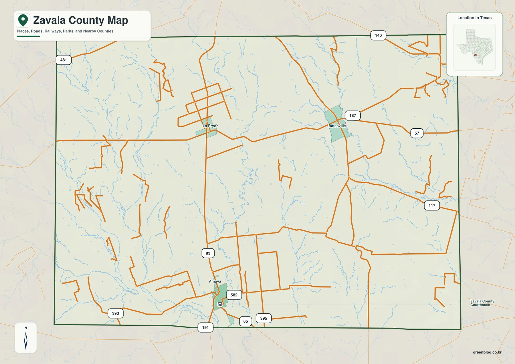
Crystal City is close to the southern county line rather than near the geographic center of Zavala County. On the general county map, La Pryor appears well to the north, Batesville lies to the northeast, and a web of secondary roads fills the space between them. This arrangement matters because a reader looking only at the county outline might expect the main communities to be more evenly distributed. Instead, the mapped settlements form separate southern, northwestern, and northeastern reference points.
U.S. 83 is the clearest north-south route on the map, passing through the La Pryor area and continuing toward Crystal City. Around Batesville, U.S. 57 provides an important east-west reference, while Route 187 is shown between the La Pryor and Batesville areas. Near Crystal City, additional numbered roads including 393, 582, 65, 395, and 191 create a denser local network. The map is useful for orientation, but anyone planning a drive should still check current highway conditions and official navigation information.
Why the city view puts so much emphasis on Crystal City
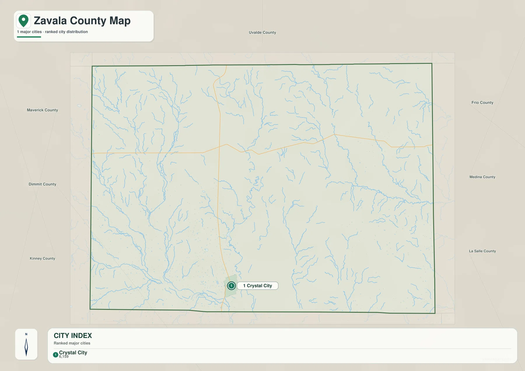
The city-distribution map deliberately simplifies the county and highlights Crystal City as the principal city. That makes it different from the general reference map, where La Pryor and Batesville also receive visible labels. Around the outside of the county, the map identifies neighboring areas including Uvalde, Frio, Dimmit, Maverick, Kinney, Medina, and La Salle counties. This broader frame is helpful when the goal is to understand where Zavala County sits within Southwest Texas rather than to follow every local road.
Crystal City’s southern position is especially clear in this version. The city is close to the Dimmit County side of the boundary, leaving a large amount of county territory to the north. A traveler or student can therefore use the city map to establish a simple mental picture first, then return to the county map for La Pryor, Batesville, and the numbered road connections. Keeping those two tasks separate makes the map set easier to use than trying to put every label into one crowded image.
The Nueces River, Leona River, and smaller water features
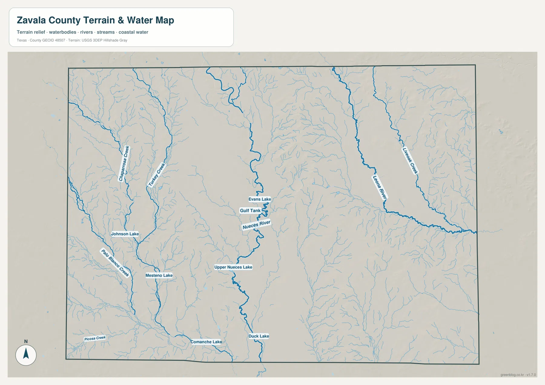
The terrain-and-water map shows that Zavala County is not defined by a single river. The Nueces River is the strongest central feature, running roughly north to south through the middle of the mapped area. Names placed near it include Evans Lake, Gulf Tank, and Upper Nueces Lake. Farther south, Comanche Lake and Duck Lake provide additional reference points. These labels make it possible to follow the river corridor without relying only on the county road network.
Western Zavala County contains a separate group of smaller streams, including Cherrymosa Creek, Turkey Creek, Palo Blanco Creek, and Picosa Creek, along with Johnson Lake and Mesteno Lake. On the eastern side, the Leona River and Liveoak Creek form another recognizable drainage area. The many thin tributaries branching away from these larger channels explain why the water map looks much more detailed than the general county map. It is a reference for visible waterways and terrain, not a flood-risk, parcel, legal-boundary, or boating-navigation product.
How elevation changes from the river corridors to northern Zavala County
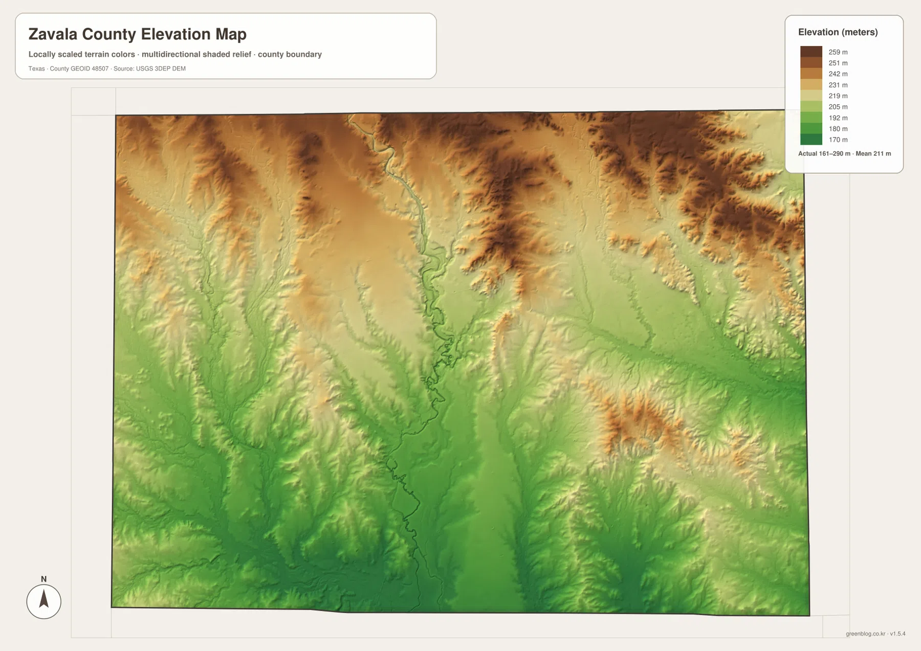
The supplied elevation map gives an actual mapped range of about 161 to 290 meters, with a mean near 211 meters. Green shades cover much of the lower southern terrain and the major river valleys, while yellow and brown tones become more common toward the north and northeast. The change is gradual rather than a single dramatic mountain front, but the shaded relief reveals many small ridges, valleys, and dissected slopes that are easy to miss on the road map.
The Nueces corridor appears as a long lower strip through the center of the county, with higher ground rising on both sides. The eastern drainage around the Leona River is also lower than several nearby ridges, while some of the darkest high-elevation shading occurs along the northern edge. This map is useful for understanding the broad shape of the land and comparing river valleys with surrounding uplands. It should not be treated as survey-grade elevation data or used as a substitute for engineering measurements at a specific property or construction site.
Reading the maps in the context of the Winter Garden region
The Texas State Historical Association places Zavala County in the Winter Garden region and describes a long connection with ranching and irrigated agriculture. That background helps explain why Crystal City and La Pryor developed as important settlement points in this part of Southwest Texas. It also gives useful context for the dense network of roads around the southern communities and for the importance of rivers and groundwater to the county’s agricultural history.
Crystal City is the present county seat and the largest town identified in the historical reference material. Batesville served as the earlier county seat and remains an important northeastern community, while La Pryor is a key northern reference point west of the Nueces River. Those facts match the geographic story visible in the supplied maps: the county has more than one local center, and the roads, river corridors, and settlement locations are spread across a large rectangular area rather than clustered around a single midpoint.
Choosing the map that fits your task
For a first look at Zavala County, start with the general county map because it combines community names, roads, the county boundary, and a light water network in one image. If the only question is where Crystal City sits within the county and how Zavala relates to surrounding counties, the city-distribution version is cleaner and faster to read. The water map becomes the better choice when you need to locate the Nueces River, Leona River, creeks, or named lakes.
The elevation map works best as a companion to the others. After locating Crystal City, the river corridor, or the northern roads, compare those positions with the relief colors to see whether they lie in lower valleys or on higher terrain. For a classroom presentation, travel overview, county profile, or personal project, using one primary map and one supporting map usually communicates the location more clearly than placing all four versions on the same page or slide.
The downloadable archive contains the same four subjects shown in the article: the county reference map, city map, terrain-and-water map, and elevation map. Each is supplied as a high-resolution A3 JPG, so you can keep the original image files instead of relying on a browser screenshot. The ZIP format also keeps the set together when you want to move the maps to another computer or save them with a research or presentation project.
Frequently Asked Questions
Where is Crystal City within Zavala County?
Crystal City is in the southern part of Zavala County, close to the Dimmit County side of the boundary. U.S. 83 runs north from the Crystal City area toward La Pryor, which makes the two communities easy to compare on the general county map.
Which waterways are easiest to identify on the water map?
The Nueces River is the most prominent central waterway, while the Leona River is farther east. The map also labels Cherrymosa Creek, Turkey Creek, Palo Blanco Creek, Liveoak Creek, Comanche Lake, Upper Nueces Lake, and several other smaller water features.
Can the elevation map be used for surveying or engineering?
No. It is a county-scale reference map designed to show broad changes in terrain. The supplied image indicates an approximate range of 161–290 meters and a mean near 211 meters, but precise construction, boundary, or survey work requires appropriate official and site-specific data.
Map File Information
Download the complete Zavala County map set as high-resolution A3 JPG files in one ZIP archive.
- Included Files: county map, city map, terrain and water map, elevation map
- File Type: four JPG files in one ZIP archive
Related Maps
Sources and references
- Texas State Historical Association – Zavala County: county location, Winter Garden background, waterways, and historical context
- Texas State Historical Association – Crystal City: county-seat and community reference
- U.S. Census Bureau TIGER/Line: county boundaries, roads, and place references
- USGS National Hydrography: rivers, streams, lakes, and hydrographic reference data
- USGS 3D Elevation Program: elevation and terrain reference data
Green Map creates custom-edited map images using open geographic data sources such as geoBoundaries, Natural Earth, OpenStreetMap, and government open data.
These maps are edited visual materials, not raw data files, and are provided for education, documents, presentations, and graphic reference.