Cherokee County occupies the far western end of North Carolina, where the state narrows into the southern Appalachian mountains beside Tennessee and Georgia. Murphy, the county seat, sits in the southwestern part of the county near the meeting of major river valleys. Andrews is farther northeast in a long, narrow valley section, with Marble between the two. That shape makes Cherokee County easier to understand when roads, rivers, and elevation are read together rather than as separate facts. This page uses the four maps actually supplied in the package: a general county map, a simplified city map, a terrain-and-water map, and an elevation map. High-resolution A3 JPG versions of all four are also available in the map file box below.
The general map gives the first orientation. U.S. 19 and U.S. 74 run through the Murphy-Marble-Andrews side of the county, while U.S. 129 and several state routes help define movement around Murphy and toward the state lines. The water map explains why those roads bend through particular valleys. Valley River approaches Murphy from the Andrews side and joins the Hiwassee River near town, while the Nottely River enters the Hiwassee system from the southwest. The elevation view adds a third layer: lower valleys carry the towns, roads, and rivers, while higher ridges rise around them. Together, the four maps show a county shaped much more by mountain corridors than by a regular road grid.
Table of Contents
The Murphy-Marble-Andrews corridor is the easiest way to orient the county
Cherokee County has an unusual outline: a broader mountainous western section narrows into an elongated northeastern arm. On the general map, the simplest way to make sense of that outline is to start at Murphy and follow the main road corridor through Marble toward Andrews. Murphy appears where several highways and local routes gather. Marble provides a middle reference, and Andrews anchors the long northeastern valley. Once those three places are located, the rest of the county boundary becomes much easier to follow because the map no longer looks like one undifferentiated mountain area.
U.S. 19 and U.S. 74 are prominent along the route from the Murphy area toward Andrews. U.S. 129 gives Murphy an important north-south reference, while NC 141 runs southward from the central-eastern side toward the Georgia direction. NC 294 and U.S. 64 are shown on the western and southwestern side, where roads have to work around reservoirs, steep ridges, and narrow valleys. The result is a road pattern with long curves and converging corridors instead of a simple grid. For a visitor trying to understand broad direction rather than a street address, these numbered highways are the most useful lines on the map.
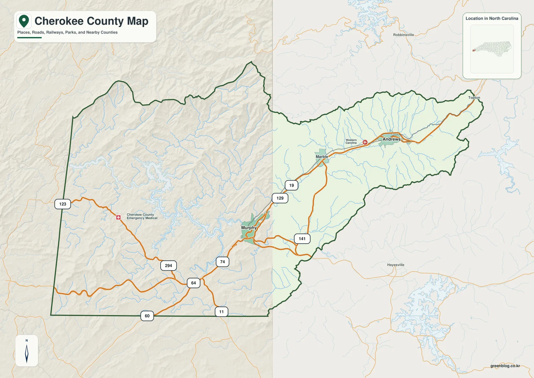
The map also includes a few useful landmarks that help with orientation. Western Carolina Regional Airport appears near Andrews, while Cherokee County Emergency Medical is marked west of Murphy. Topton is shown beyond the northeastern end as an outside reference. These labels should not be treated as a complete inventory of public facilities or communities; their value here is positional. They make it easier to say that a place lies near Andrews, west of Murphy, or toward the northeastern end without needing a dense street map. The state-line setting matters too. Because Cherokee is North Carolina’s westernmost county, Tennessee and Georgia are often more immediate direction references than distant cities farther east in North Carolina.
A simplified city view separates the roles of Murphy and Andrews
The city map strips away most highway detail and emphasizes two towns: Andrews and Murphy. That simplified presentation matches the county government’s description of Cherokee County as having the towns of Andrews and Murphy, with Murphy serving as the county seat. The two places are not shown as parts of one continuous built-up area. Murphy occupies the southwestern portion, while Andrews lies much farther northeast in the Valley River corridor. This separation is useful when explaining local geography because a destination can be in the same county yet belong to a very different mountain valley and road approach.
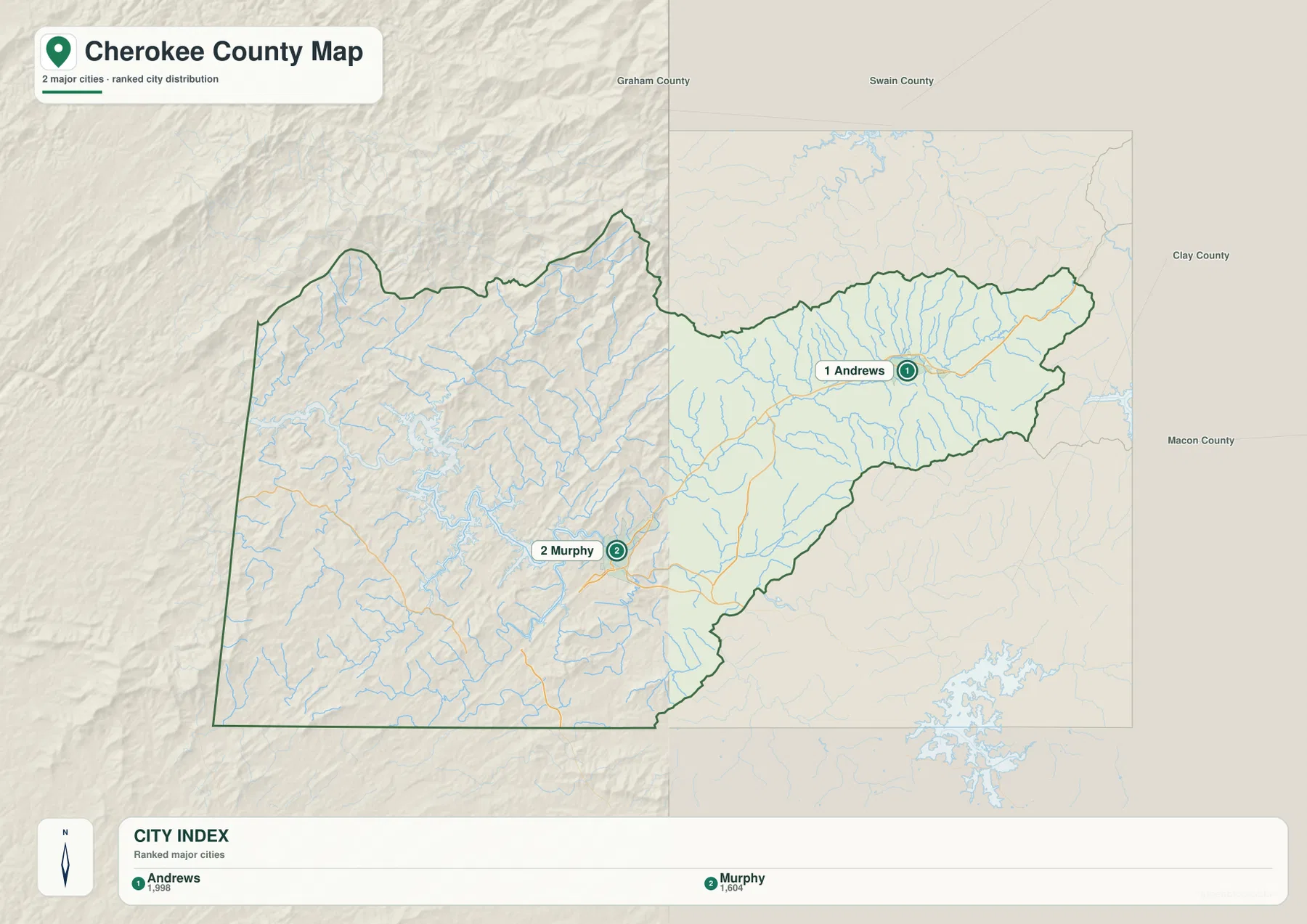
The ranking shown on the city graphic is best read as a display convention, not as a statement about county administration. Murphy remains the county seat. Andrews is important because it anchors the northeastern valley section and gives that long part of the county a clear town reference. Labels for Graham, Swain, Clay, and Macon Counties also appear around the map as regional orientation points. They help a reader understand the direction of neighboring western North Carolina areas, but the graphic should not be used by itself to decide which counties share every segment of the Cherokee boundary.
The two-town view becomes more informative when it is paired with the water map. Andrews lies along the Valley River corridor, and Murphy sits near the point where Valley River reaches the Hiwassee River. That means the towns are separated not only by distance but also by their position along the same broad drainage route. The general map adds the highway connection, while the water map explains the valley beneath that connection. For a presentation or article, the city map works well as the simple first image; the other maps can then add the road, river, and terrain detail that the city view intentionally leaves out.
Three major river routes explain much of Cherokee County’s mountain geography
The terrain-and-water map is especially valuable in Cherokee County because streams are not minor background features. The Hiwassee River is the largest organizing waterway on the western side. Valley River runs southwest from the Andrews area and reaches the Hiwassee near Murphy. North Carolina water-planning material describes the Valley River as originating near the Cherokee-Graham side and flowing generally southwest into the Hiwassee near Murphy, which matches the direction shown on the supplied map. This makes Valley River an excellent guide for understanding why Andrews, Marble, and Murphy line up along a long mountain corridor.
The Nottely River adds another major direction from the south and southwest. Federal and North Carolina records identify the Nottely in Cherokee County and place its lower course near the Hiwassee system west of Murphy. Smaller labeled waterways include Hanging Dog Creek, Peachtree Creek, Martin Creek, Shoal Creek, and Persimmon Creek. None of those tributaries needs to be memorized to use the map, but their number matters. The dense branching network shows how frequently ridges are cut by small valleys, which in turn helps explain the winding road network and the limited amount of broad, flat land.
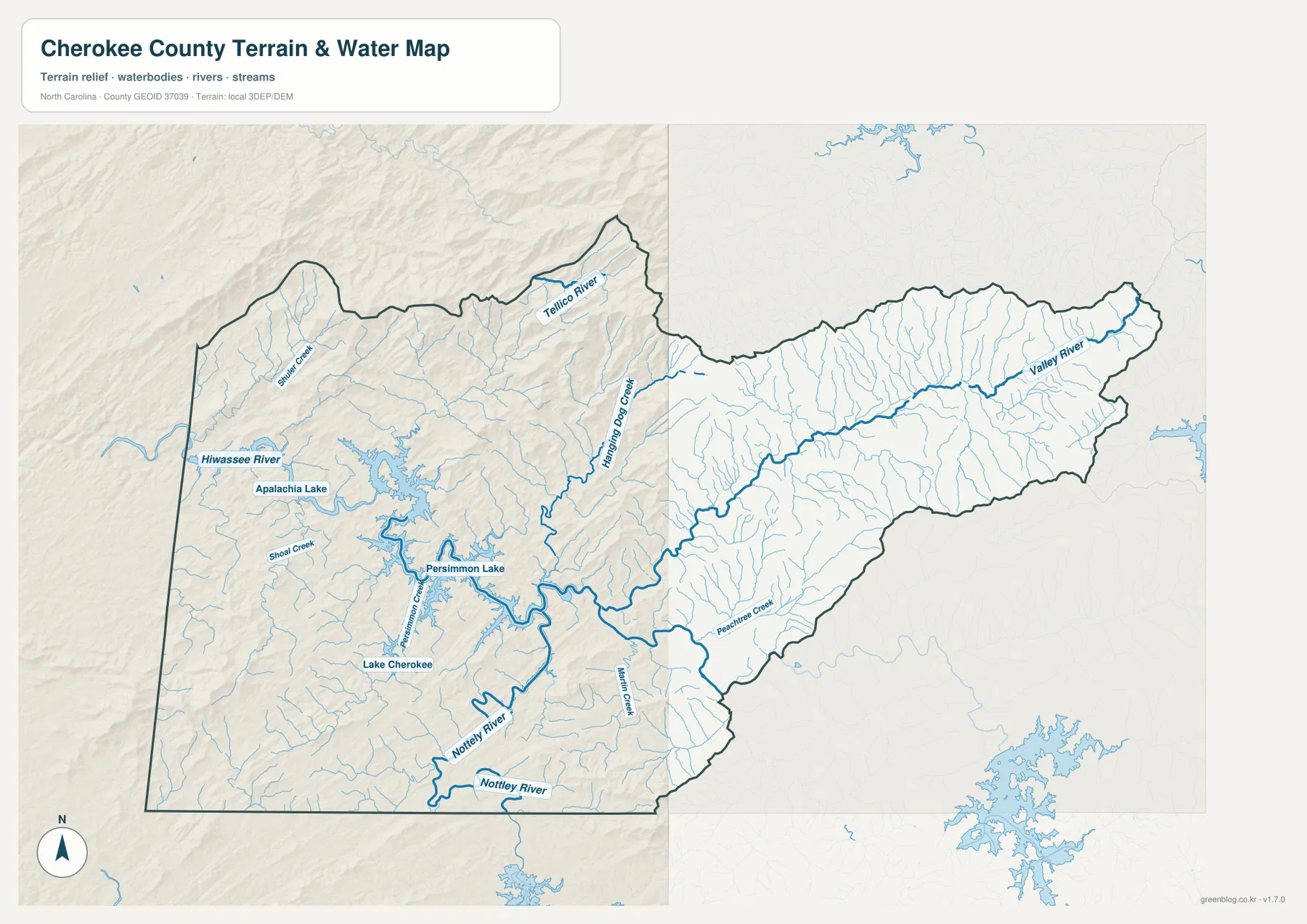
Several broad reservoir surfaces are visible in the western half, along with labels such as Apalachia Lake and other local lake references. The important point for this page is not shoreline access or reservoir operations, which require specialized current information, but the way open water occupies mountain valleys and interrupts otherwise continuous ridges. West and northwest of Murphy, the river-and-reservoir pattern creates a much more irregular landscape than the long Valley River corridor toward Andrews. A general road map can make both areas look like parts of the same county network; the water map shows why traveling through them can feel very different.
Road and water lines often run in similar directions because both follow the available low ground. The U.S. 19/U.S. 74 corridor toward Andrews parallels the Valley River valley for much of its route. Roads west of Murphy bend around reservoir arms and mountain slopes, and southern routes use the lower ground around the Nottely and smaller tributaries. This does not mean every road directly follows a river, but it does explain the overall pattern: the practical movement corridors are constrained by ridges. When two points look close in straight-line distance, the river and terrain maps help explain why the road distance can be noticeably longer.
Elevation separates the high ridges from the lower river valleys
The elevation map makes Cherokee County’s mountain setting explicit. Its legend reports an actual elevation range of roughly 354 to 1,520 meters, with a mean near 607 meters. That is a large vertical range within a single county. Higher terrain is shown in warmer tan and brown colors, while lower valleys appear in green. The strongest high-relief areas stand out along the northern and northwestern ridges, with repeated narrow valleys cutting into them. Lower corridors correspond broadly with the river valleys where the general map places roads and towns.
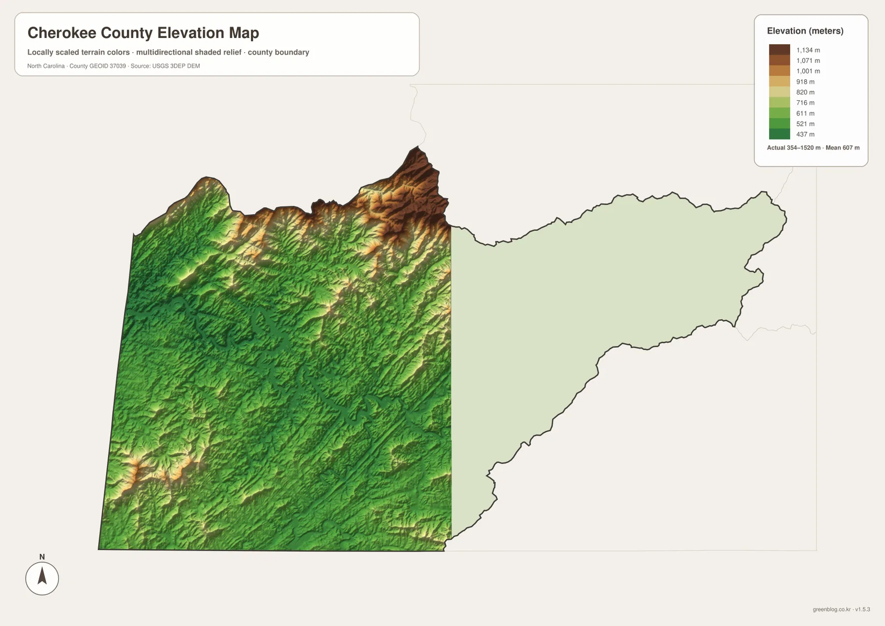
Murphy and Andrews make sense in that elevation context. Murphy occupies a lower valley area where major waterways meet, while Andrews sits in the long Valley River corridor. The high ridges around those valleys limit direct cross-county routes and create the strongly folded appearance visible in shaded relief. This is one reason the elevation map adds information that the water map cannot provide alone. Blue stream lines show where water runs, but the elevation colors show the higher ground that separates one drainage path from another.
Elevation color should not be confused with land ownership, zoning, buildability, or parcel-level slope. The map is a broad terrain reference. It is useful for explaining that one part of the county lies in a high ridge zone while another follows a lower river valley, but it is not a substitute for a survey or engineering-grade terrain model. If a project requires exact elevations, slope calculations, or site-specific measurements, the USGS 3D Elevation Program data referenced in the sources is the more appropriate starting point.
The Tennessee and Georgia borders are part of everyday map orientation here
Cherokee County’s official area information identifies it as North Carolina’s westernmost county and notes that it borders Tennessee and Georgia. On the county map, that setting is not just a statewide fact; it changes how local direction works. The western and southern edges open immediately toward other states, while the northeastern arm points back into western North Carolina. Murphy therefore serves as a useful reference for routes that may continue toward Georgia or Tennessee as easily as for routes heading east across North Carolina.
The county’s history page notes that Cherokee County was formed in 1839 from part of Macon County. That historical fact is secondary to the map itself, but it helps explain why county lines in the far western mountains do not necessarily follow a simple rectangular pattern. Present-day boundaries cross a landscape already divided by mountain ridges and drainage basins. When reading the map, it is often more helpful to connect a border crossing with the river valley or highway that reaches it than to treat the county line as an isolated feature.
Choose the map by the question you need to answer
Use the general county map when you need Murphy, Marble, Andrews, numbered highways, county boundaries, and several reference facilities in one view. Choose the city map when the main goal is simply to compare Murphy and Andrews without the distraction of a dense road network. The terrain-and-water map is better for the Hiwassee, Valley, and Nottely rivers, reservoir surfaces, tributaries, and the relationship between water and mountain valleys. The elevation map is the clearest choice when the point of the illustration is the contrast between high ridges and lower corridors. Keeping all four files together makes it easy to switch from a simple location explanation to a more physical-geography-focused view.
- General Cherokee County JPG: Murphy, Marble, Andrews, major highways, county boundaries, and selected reference locations
- Cherokee County city JPG: a simplified comparison of the positions of Andrews and Murphy
- Cherokee County terrain-and-water JPG: Hiwassee River, Valley River, Nottely River, reservoirs, and smaller creeks
- Cherokee County elevation JPG: mountain ridges, lower valleys, and county-scale elevation differences
Frequently Asked Questions
Should Murphy or Andrews be treated as the main center of Cherokee County?
Murphy is the county seat and the administrative center. Andrews is still essential for map orientation because it anchors the long northeastern Valley River section. A useful way to read the county is to treat Murphy as the southwestern administrative and road reference and Andrews as the principal town reference for the northeastern valley.
Why are the Hiwassee River and Valley River especially useful on this map?
Valley River runs southwest from the Andrews side and reaches the Hiwassee near Murphy, so the two rivers connect the county’s two most visible town references through one mountain corridor. Adding the Nottely River from the southwest shows that Murphy also sits close to another major drainage route, making the town a useful point for understanding the county’s river network.
What should I look for first on the Cherokee County elevation map?
Start by comparing the warmer high-ridge colors with the greener valley corridors. The map legend reports an actual range of about 354 to 1,520 meters and a mean near 607 meters, showing that relief changes substantially across the county. The map is intended for broad terrain interpretation, not parcel-level elevation or engineering measurements.
What files are included in the Cherokee County map download?
The ZIP contains high-resolution A3 JPG versions of the general county map, the simplified city map, the terrain-and-water map, and the elevation map. The WebP images in the article are previews, while the downloadable JPG files are better suited to larger displays, documents, and printing.
Sources and Reference Data
County-seat, town, border, and historical context were checked against Cherokee County government information. Boundary, hydrography, and elevation references were also compared with the federal geographic data sources used by the map package. These maps are intended for county-scale orientation; parcel, flood, survey, and engineering decisions should use the corresponding official source data.
- Cherokee County – Area Information
- Cherokee County – Cherokee County History
- U.S. Census Bureau TIGER/Line Shapefiles
- USGS National Hydrography
- USGS 3D Elevation Program
- North Carolina DEQ – Valley River Watershed
Map File Information
The download ZIP contains four high-resolution A3 JPG maps for Cherokee County. Use these larger files when the WebP previews in the article are not large enough for printing, presentations, or detailed viewing.
- Included Files: Use only the versions confirmed in the article and supplied images
- File Type: Use the confirmed download contents
- Intended Use: Printing, education, presentations, and map-based projects
Related Maps
Green Map creates custom-edited map images using open geographic data sources such as geoBoundaries, Natural Earth, OpenStreetMap, and government open data.
These maps are edited visual materials, not raw data files, and are provided for education, documents, presentations, and graphic reference.