Chowan County sits in northeastern North Carolina where a long, narrow stretch of Coastal Plain meets several large bodies of water. Edenton is near the southern end of the county, the Chowan River forms the dominant water reference along the west, and Albemarle Sound opens across the south. The maps on this page are built around those relationships rather than around a dense list of place names. You can use them to see the county boundary, major numbered roads, the position of Edenton, and the network of rivers, creeks, millponds, and shoreline that gives Chowan County its distinctive outline.
The images in the article are web-sized previews, while the download package contains matching high-resolution A3 JPG files for the county, city, and water views. That makes the page useful both for quick orientation and for readers who need a larger map for printing, a class project, a report, or a local reference sheet. Chowan County does not need a mountain or elevation map to explain its basic geography. NCpedia places the county in North Carolina’s Coastal Plain, and the supplied maps show a low-relief landscape in which water, roads, and the location of Edenton are more useful orientation points than dramatic changes in height.
Table of Contents
A long county shape anchored by Edenton and US 17
The general county map makes Chowan’s shape easier to understand than a road list alone. Edenton is clustered near the southern end, while the county extends far north in a relatively narrow band before widening and bending around waterways. The Chowan County Courthouse is marked in Edenton, reinforcing the town’s role as the county seat. From there, the eye can follow the main road network toward the interior and then compare it with the county boundary. This is especially useful because the administrative center is not positioned in the geometric middle of the county; it is tied much more closely to the southern waterfront.
US 17 is the easiest highway to use as a first reference. It passes through the Edenton area and continues across the county, linking Chowan with neighboring parts of northeastern North Carolina. The map also labels Routes 32, 37, and 94. NCDOT planning material confirms those routes as important parts of the county network, with NC 32 serving Edenton and extending north toward Gates County while NC 37 and NC 94 provide additional connections on the eastern and southern sides. A reader does not need to memorize every route number. Finding US 17 and Edenton first, then adding the other highways, gives a much clearer picture of how the road system fits the county’s unusual shape.
The surrounding county names add another layer of orientation. Gates County is to the north, Perquimans County lies to the east, and Pasquotank appears farther to the southeast on the city view. Hertford and Bertie are on the western side of the broader area, with major water separating parts of those boundaries from Chowan. This setting matters because a straight county line is only part of the story. Along the west and south, the edge of Chowan County is visually tied to the Chowan River and Albemarle Sound, so the boundary is easier to remember when it is connected to water rather than treated as an abstract line.
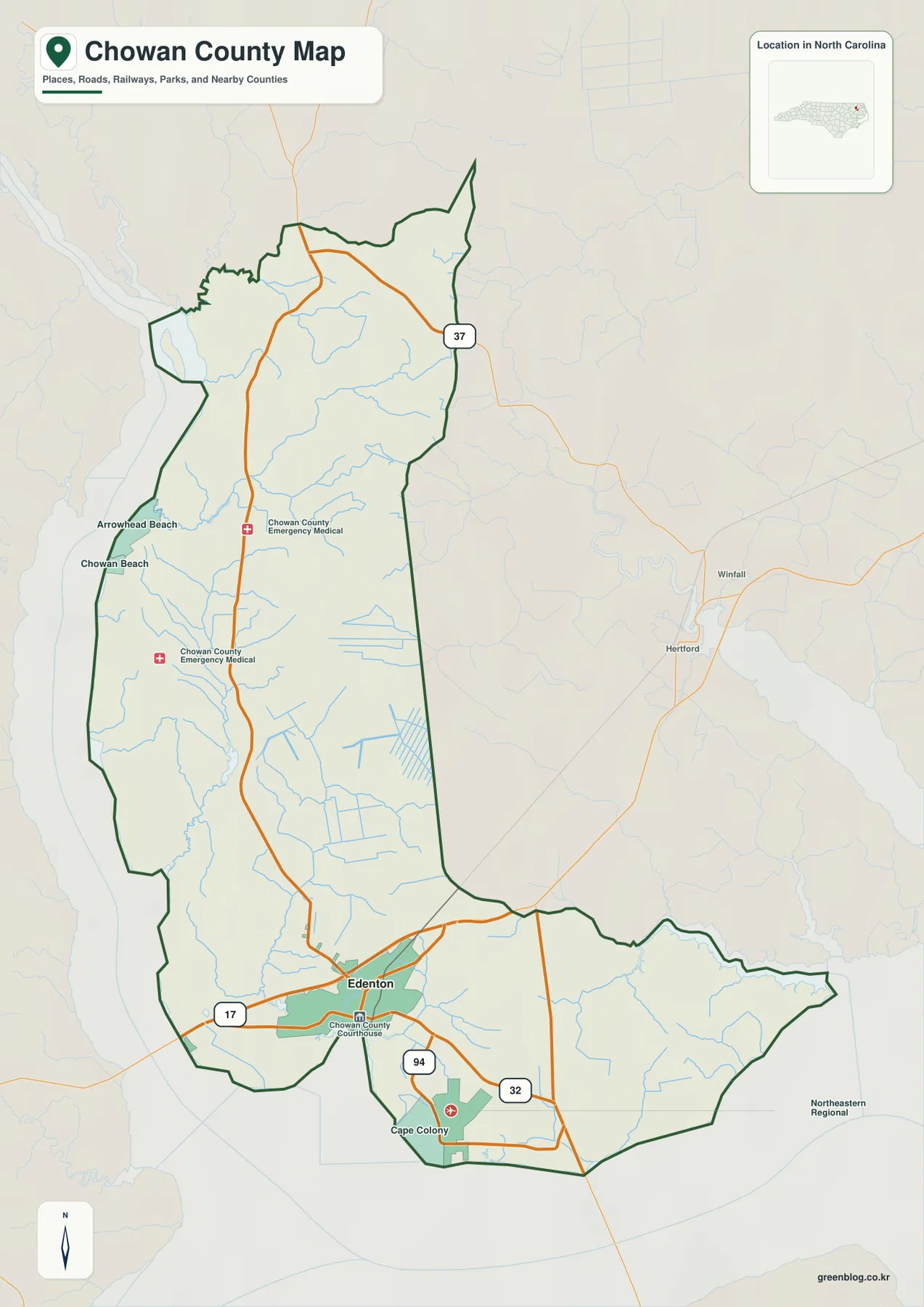
This map is best used for county-scale orientation rather than turn-by-turn navigation. It can answer questions such as whether a place is north or south of Edenton, how the main highways cross the county, and which direction leads toward Perquimans or Gates County. It is not a parcel map, a property survey, or a live traffic product. If the next step is to locate an address, a driveway, or a legal boundary, a detailed street or parcel source should follow this overview instead of being replaced by it.
Why the city index puts nearly all of the emphasis on Edenton
The city map deliberately simplifies the settlement picture. Its ranked city index highlights Edenton as the major city reference, making the southern concentration of population and services immediately visible. That does not mean the rest of Chowan County is empty. Smaller communities, including Tyner, are part of the county, but this particular map is designed to show the major city position rather than label every rural settlement. The result is a cleaner way to see how strongly the county’s urban reference point is concentrated around Edenton instead of being split among several similar-sized towns.
Edenton’s location is also more meaningful when the map is read together with the surrounding counties. Gates County is shown north of Chowan, Perquimans to the east, Pasquotank farther east and southeast, and Hertford and Bertie on the western side. With Edenton marked near the lower part of Chowan County, the reader can quickly see that the county seat is much closer to the Albemarle waterfront than to the northern tip of the county. That distinction is easy to miss on a generic North Carolina map where the county is only a small polygon.
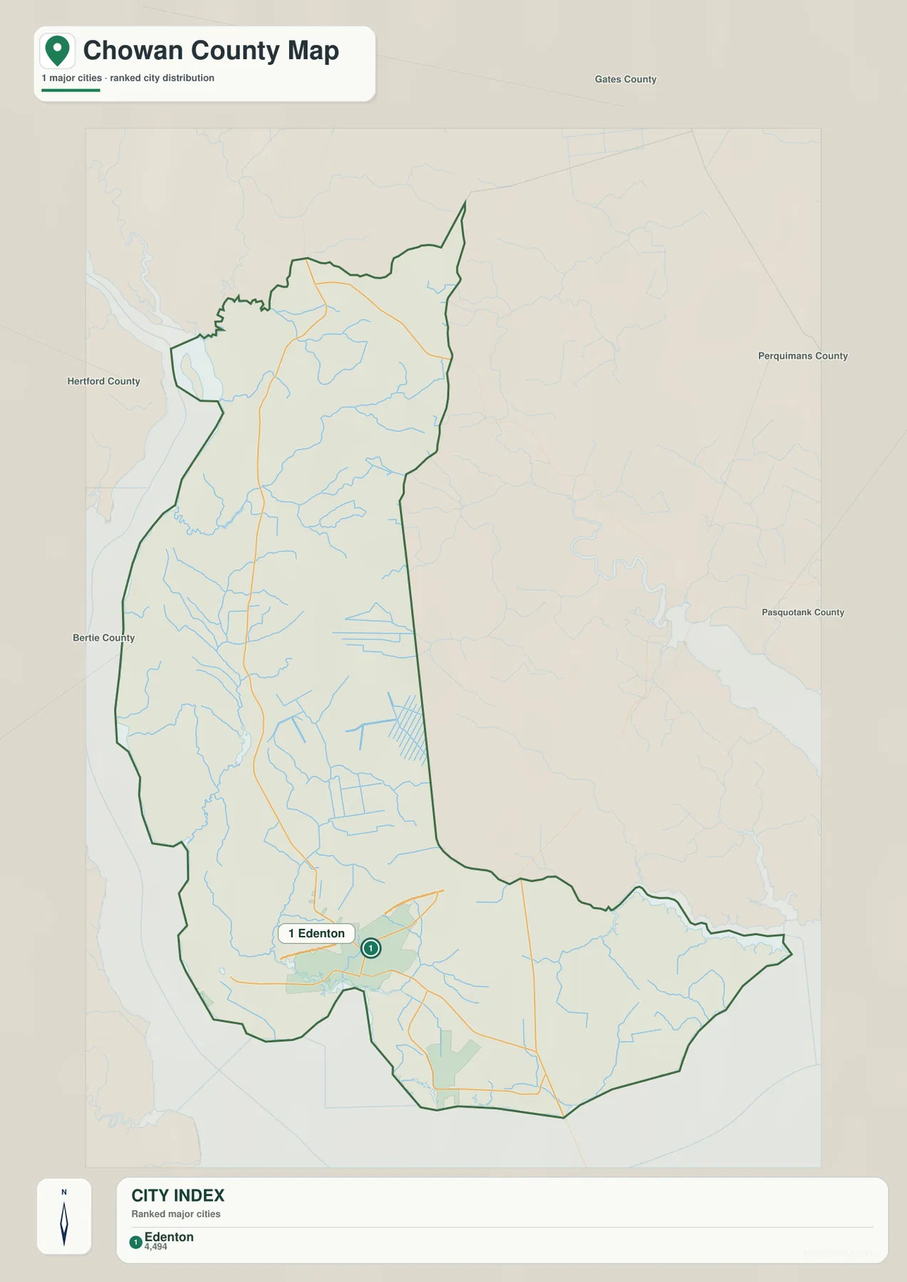
For a classroom map or a short regional profile, this simplified view can be more useful than a crowded settlement map. Edenton provides one clear anchor, and the county outline shows how much territory extends north from it. For local research, however, the city map should be treated as a starting point. Readers looking for Tyner, Rocky Hock, or other smaller communities will need a more detailed road or place-name source after they establish the county-level relationship shown here.
From the Chowan River to Yeopim River, water defines the county edges
The water map reveals why Chowan County is easier to understand from its shoreline inward. The Chowan River is the large blue feature along the western side, while Albemarle Sound spans the southern and southeastern edge. At the eastern end, Yeopim River reaches toward the sound, and Yeopim Creek is labeled just to the north. These three large references create a simple mental frame: Chowan River on the west, Albemarle Sound on the south, and the Yeopim system toward the east. Once that frame is clear, the smaller creeks and ponds fall into place.
Several named waterways show how detailed the drainage network becomes away from the main shoreline. Bennetts Creek and Stumpy Creek appear in the northwestern part of the map, with Indian Creek extending through the northern interior. Dillard Millpond is marked near the Chowan River side, while Rockyhock Creek and Bennett Millpond provide additional references farther south. In the lower half of the county, Pollock Swamp and Pembroke Creek lead toward the Edenton-area waterfront, Queen Anne Creek is labeled nearby, and Middleton Creek appears farther east before the Yeopim system. These names are useful because they show that the county’s water geography is not simply one river plus one sound; it is a branching network of smaller channels and low-lying wet areas.
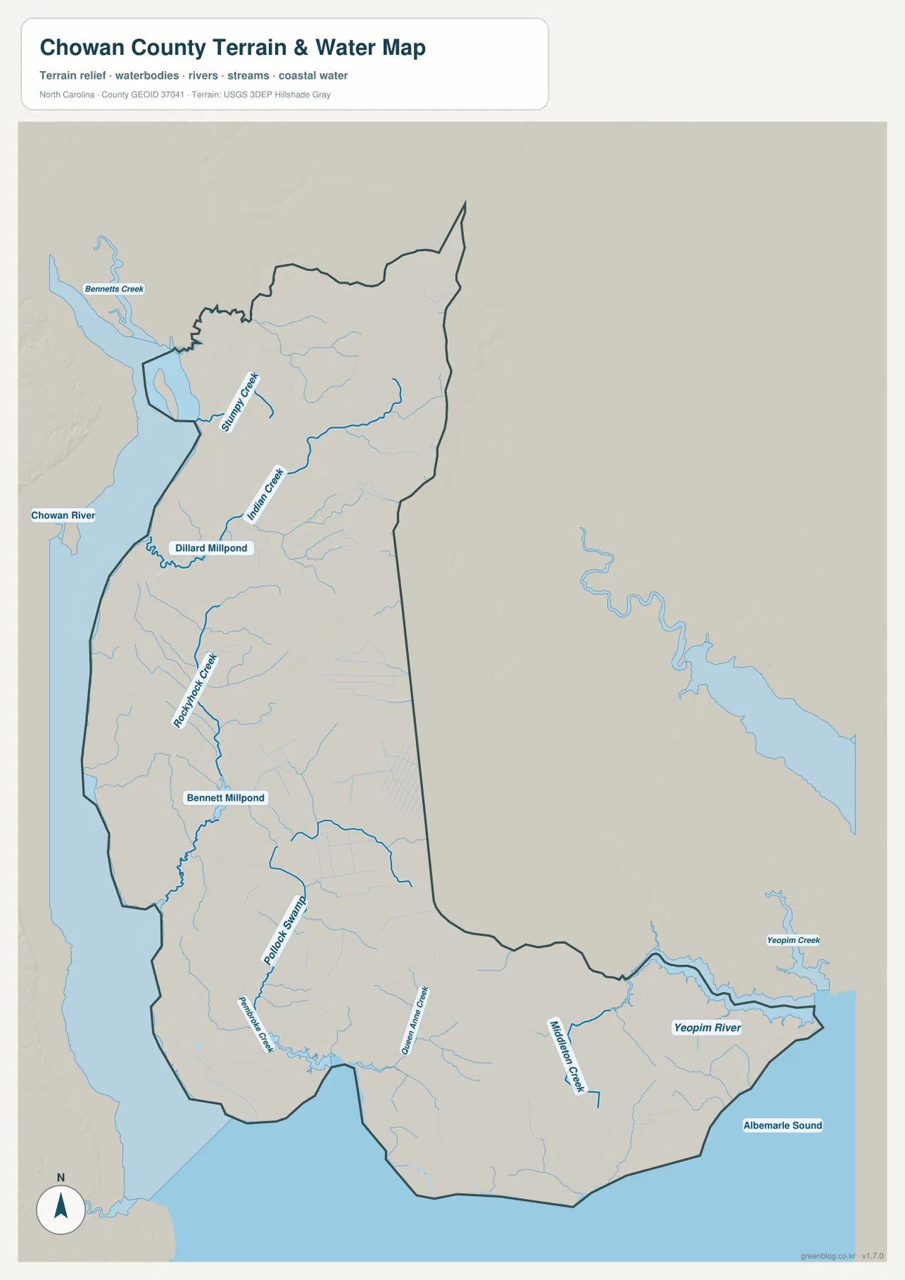
The subdued terrain shading is consistent with Chowan County’s Coastal Plain setting. There are no major mountain chains or sharp relief breaks dominating the view. Instead, the important contrasts are between broad water, low inland surfaces, and the many creeks that work their way toward larger rivers and the sound. That is why a water-first reading is so effective here. In a mountain county, elevation might determine the first orientation step; in Chowan County, the shoreline and drainage network do much more of that work.
This is still a general water-reference map, not a flood map or a navigation chart. It does not show flood probability, expected water depth, channel depth, tidal conditions, or safe boating routes. The map can help a reader locate a creek relative to Edenton or understand which side of the county faces the Chowan River, but decisions involving flooding, emergency planning, construction, or boating should use the appropriate current agency data. Keeping that limitation in mind makes the map more useful because its purpose stays clear.
Edenton’s historic role makes more sense when its waterfront position is visible
Chowan County was formed in 1668, making it one of North Carolina’s oldest county jurisdictions, and Edenton has a long history as an administrative and commercial center. NCpedia describes Edenton at the head of Albemarle Sound and notes its importance during the colonial period. That history is easier to understand when the modern map is in front of you. Edenton is not an inland seat placed near the center of a large county; it is a small waterfront town near the southern edge, with roads converging on it and major water immediately nearby.
The water map also labels Queen Anne Creek in the southern part of the county, a name that connects naturally with Edenton’s early history. The point here is not to turn the map page into a full historical guide, but to show how physical geography and settlement history reinforce each other. A port-oriented community would be expected to sit close to navigable water, and Edenton’s location along the Albemarle system explains why the town remains the easiest geographic anchor for the county today.
Choose the view by the question you are trying to answer
Start with the county map when you need the boundary, Edenton, major roads, and a broad sense of nearby places in one image. It is the strongest choice for general orientation, travel planning at the county scale, or explaining where Chowan sits within northeastern North Carolina. Use the city map when the main question is settlement concentration. Its simplicity makes the southern focus on Edenton obvious without the distraction of a long place-name list. Switch to the water map when the Chowan River, Yeopim River, Albemarle Sound, creeks, millponds, or low-relief terrain are the subject.
Combining the views can be even more useful. A student might use the county map to identify US 17 and the county seat, then add the water map to explain why the western and southern boundaries look the way they do. A local-history project could begin with Edenton on the city map and then use Queen Anne Creek and Albemarle Sound as physical references. A printed handout can use the high-resolution JPG files so labels remain clearer than they would in a screenshot of the web preview.
The download archive is intentionally limited to the three map types that are actually available for this county package. There is no elevation-map placeholder in this set, so the page does not pretend to provide a separate elevation product. That keeps the description aligned with the files a visitor receives and avoids the common problem of promising a map that is not present in the archive.
Frequently Asked Questions
Why is water a better first orientation point than roads on a Chowan County map?
The Chowan River dominates the western side, Albemarle Sound spans the south, and the Yeopim River system marks the eastern end. Those large water features explain much of the county outline. Once they are located, Edenton and US 17 fit into the map much more naturally, so the road network becomes easier to follow instead of being the only reference.
Does the city map mean Edenton is the only community in Chowan County?
No. The supplied city-index map highlights the major city reference and therefore emphasizes Edenton. Smaller communities such as Tyner are part of Chowan County even though they are not given the same visual weight on this simplified view. A detailed road or place-name map is better when the goal is to locate every small community.
Can the water map be used to judge flood risk or boating conditions?
No. It is a geographic reference showing rivers, creeks, millponds, swamps, and Albemarle Sound in relation to the county boundary. It does not contain flood zones, expected water depths, channel depths, tides, or navigation information. Flood planning and boating decisions should use current specialized data from the appropriate federal, state, or local agency.
Map File Information
The ZIP contains the Chowan County reference map, city map, and water map as high-resolution A3 JPG files. Use the archive when you need a larger image for printing, documents, classroom materials, or a local reference sheet.
- Included Files: county map, city map, water map
Related Maps
Sources and References
The county setting, historical context, road network, and water references were checked against the following public and official sources.
Green Map creates custom-edited map images using open geographic data sources such as geoBoundaries, Natural Earth, OpenStreetMap, and government open data.
These maps are edited visual materials, not raw data files, and are provided for education, documents, presentations, and graphic reference.