This Taylor County Texas Map set uses Abilene as the main urban reference, then follows the smaller towns west and south, the Elm Creek and Jim Ned Creek drainage, and a rugged band of higher terrain across the southwest. Download the high-resolution A3 JPG map ZIP from the box below when you need printable or editable files; it contains separate county-reference, ranked-city, terrain-and-water, and elevation maps.
Taylor County has a clear contrast between the Abilene-centered northeast and the more rugged southern and western interior. Merkel and Tye line up west of Abilene, while Tuscola, Buffalo Gap, and Lawn are spread across the southern half. The water map adds Elm Creek, Jim Ned Creek, Lake Abilene, and several smaller lakes, while the elevation surface shows a broad southwestern ridge belt rising well above the lower northeast.
Table of Contents
Abilene anchors the road network while Merkel and Tye extend west
Abilene is the strongest landmark on the county reference map. Tye sits immediately to the west, and Merkel is farther along the same general corridor. Route shields 20 and 84 are visible west of Abilene, while 36 runs southeast from the city and 351 appears to the northeast. Those larger labels create a useful frame before the smaller county roads are considered.
South of Abilene, Buffalo Gap becomes a central reference, with Tuscola farther east and Lawn close to the southeastern boundary. Route 277 is visible near the southwest edge, 153 is nearby, 83 appears across the southern interior, and 142 provides another reference near the Lawn side. Reading the map from Abilene toward those three southern places is an easy way to separate the dense northern urban area from the more lightly settled countryside.
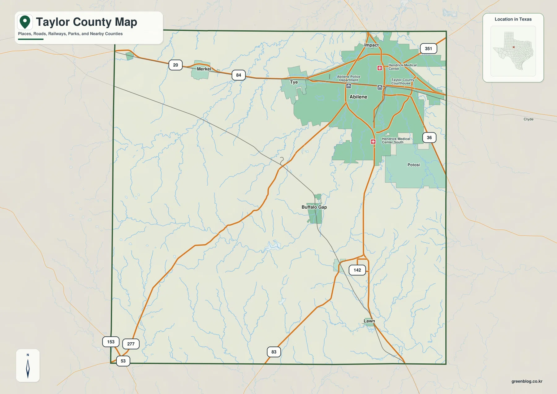
The blue drainage pattern is noticeably denser south and west of the main urban area. Roads cross many small creek valleys around Buffalo Gap and toward the southwestern high ground. That contrast makes the county reference layer more than a road map: it already hints at the relief differences that become much clearer on the water and elevation maps.
Six ranked cities divide the county into a northern urban side and southern small towns
The ranked city map highlights Abilene, Merkel, Tuscola, Tye, Buffalo Gap, and Lawn. Abilene dominates the northeastern part of the county, with Merkel and Tye extending west across the northern side. Tuscola and Buffalo Gap occupy the south-central interior, while Lawn sits near the southeastern edge. Removing most minor place labels makes that north-south difference much easier to recognize.
The CITY INDEX prints map values of 128,053 for Abilene, 2,699 for Merkel, 990 for Tuscola, 936 for Tye, 534 for Buffalo Gap, and 280 for Lawn. These figures explain the ranking used in the supplied graphic and should be treated as map values rather than guaranteed current population estimates. Current demographic work should use an official statistical source.
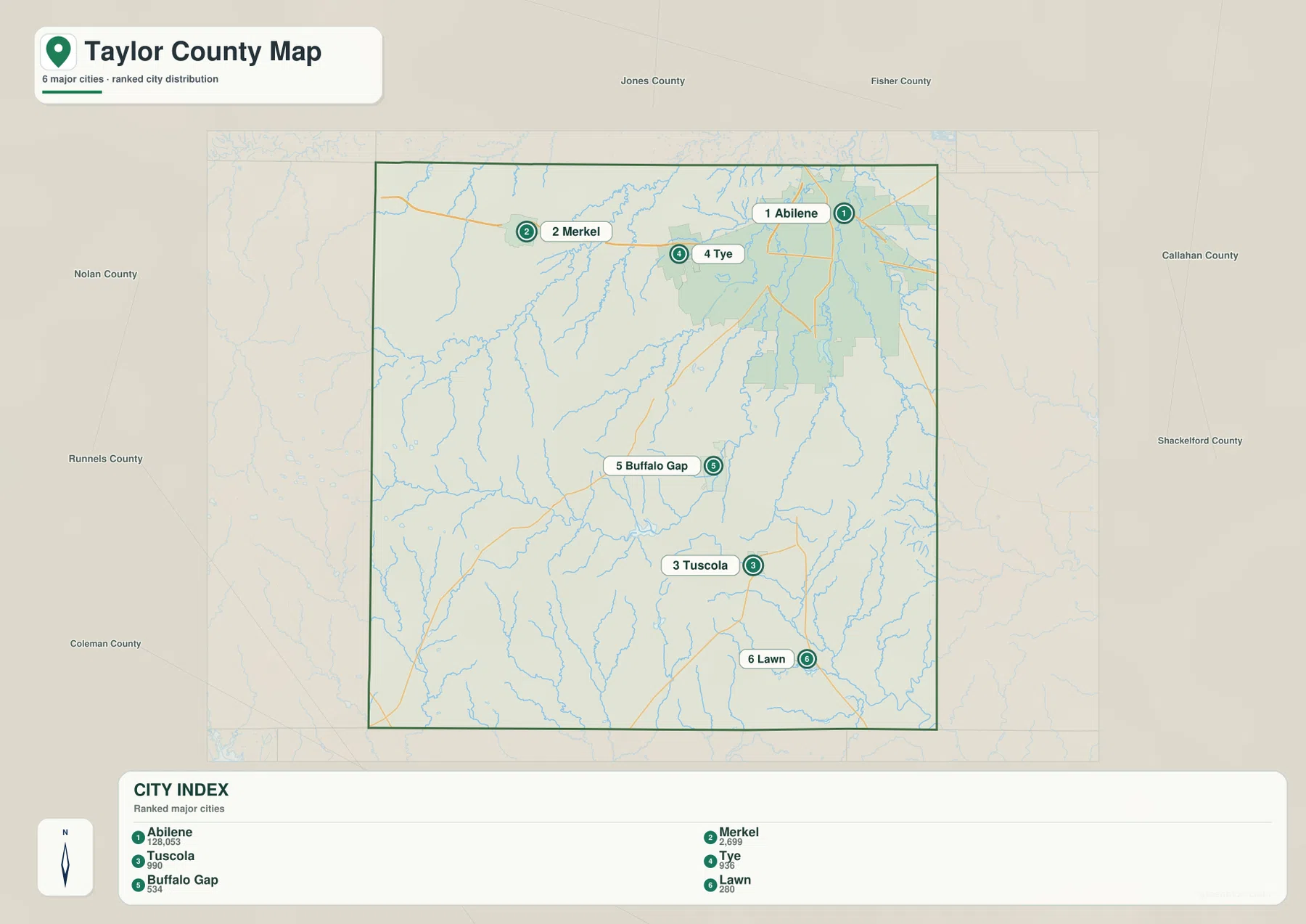
Neighboring county names provide another useful frame. Jones and Fisher counties are shown to the north, Nolan County to the west, Runnels and Coleman counties toward the southwest, and Callahan and Shackelford counties to the east. Abilene sits much closer to the eastern side than Merkel does, which helps explain why the urban footprint appears offset rather than centered inside the county.
Elm Creek and Jim Ned Creek cross the low corridors between higher ridges
The terrain-and-water map shows several strong drainage references. Mulberry Creek and Bull Wagon Creek occupy the northwest, while Little Elm Creek runs through the west-central interior. Elm Creek follows a lower corridor farther south and passes the Lake Abilene area, making it one of the easiest waterways to connect with the county’s relief.
Lake Abilene is one of the clearest named water bodies near the middle-southern part of the map, and Graham Lake is farther south. Bluff Creek follows a separate southwestern valley. In the southeast, Jim Ned Creek runs through a long drainage corridor near Santa Fe Lake. Closer to Abilene, Lytle Creek and Cedar Creek are accompanied by Lytle Lake, Canyonrock Lake, and Kirby Lake, creating a cluster of water references on the eastern side of the county.
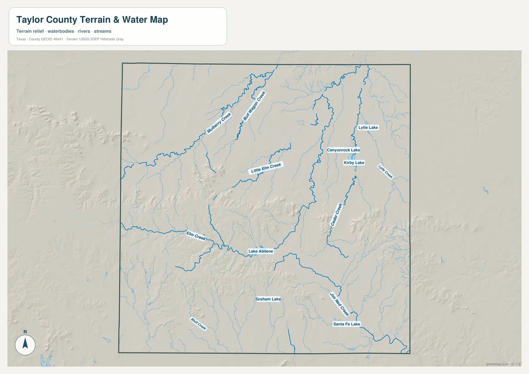
This layer is intended for geographic water reference rather than flood-hazard analysis, parcel boundaries, navigation, or reservoir operations. Its most useful role here is to show how creek valleys cut through the higher western and southern terrain and how the Abilene-side lakes fit into the lower eastern drainage.
Southwestern ridges rise well above the Abilene side of the county
The elevation map reports an actual range of about 498 to 762 meters and a mean elevation of 611 meters. The darkest brown high ground forms a broad belt across the southwest and continues into the south-central interior. Another isolated high area appears farther west, while the northeast around Abilene is mostly green and therefore substantially lower.
The southwestern terrain is not one smooth ridge. Deep green and yellow-green valleys cut through the high ground, and Elm Creek follows one of the most important lower corridors toward the Lake Abilene area. Smaller ridges reappear in the central-east and southeast, but they are separated by broad lower surfaces. Comparing the water and relief maps makes the relationship between these creek valleys and the higher ridge blocks much easier to understand.
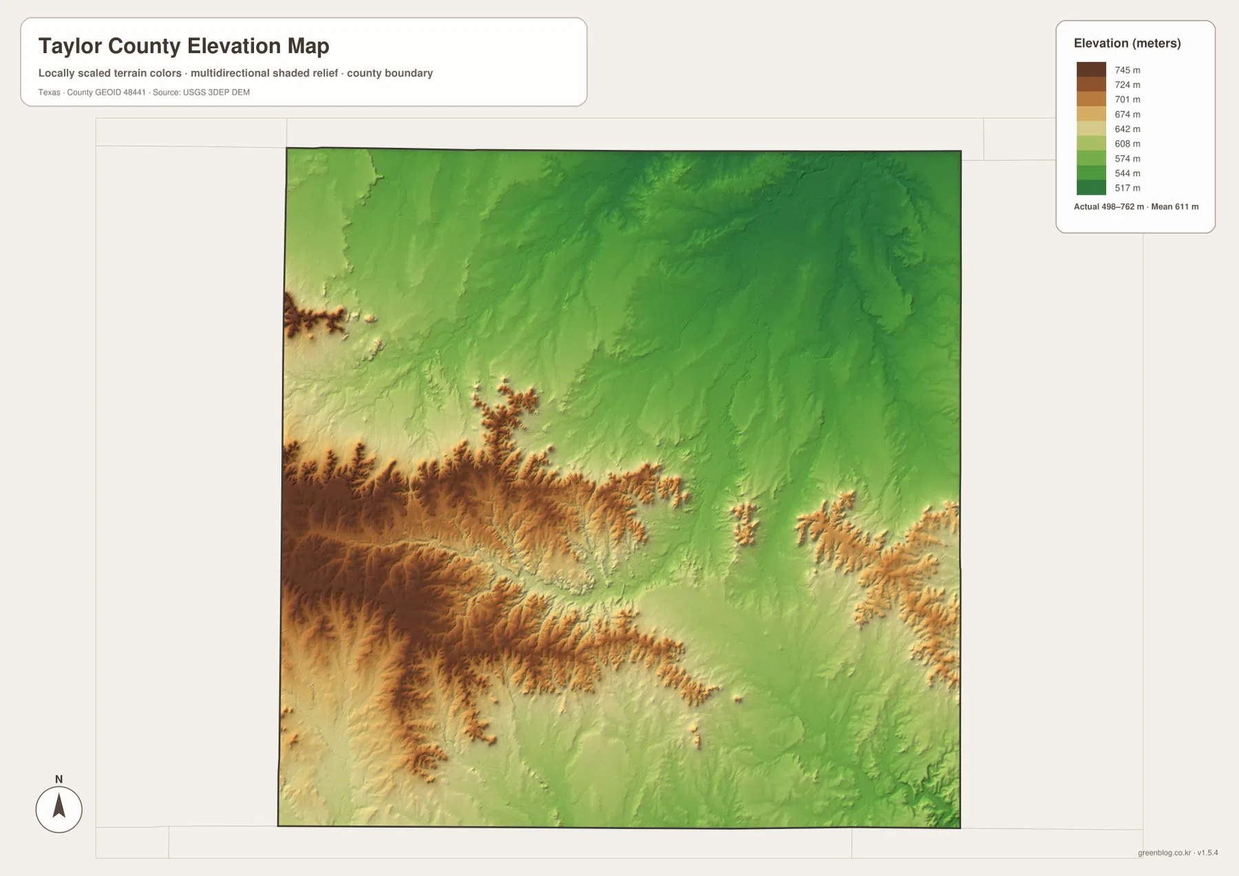
This countywide elevation surface is designed for broad terrain comparison rather than parcel surveying or engineering design. It is useful for seeing why the southwest looks more rugged, where lower creek corridors cut through the ridges, and how the terrain around Abilene differs from Buffalo Gap and Tuscola. Exact site elevation should be checked with detailed source data or a local survey.
Choose the view by whether roads, towns, water, or relief matters most
Use the county reference map when Abilene, Merkel, Tye, the southern towns, route labels, and the county boundary need to appear together. The ranked city map is cleaner for comparing the six principal mapped communities. The terrain-and-water view is the best place to trace Elm Creek, Jim Ned Creek, Lake Abilene, and the Abilene-area lakes, while the elevation map makes the southwestern ridge belt and lower northeast easiest to compare.
The downloadable ZIP contains four separate high-resolution A3 JPG files for Taylor County: county reference, ranked city, terrain and water, and elevation. You can inspect the WebP versions in the article first and then use the larger JPG files for printing, classroom material, presentations, or an editable local-reference document.
Frequently Asked Questions
Where are Merkel and Tye compared with Abilene?
Tye is immediately west of Abilene on the supplied maps, and Merkel is farther west along the same broad northern corridor. Route shields 20 and 84 help identify that direction.
Where is Lake Abilene on the Taylor County water map?
Lake Abilene is south of the county’s center along the Elm Creek drainage. It provides a useful water reference for the Buffalo Gap and Tuscola side of the county.
What elevation range is shown for Taylor County?
The supplied elevation map states an actual range of about 498 to 762 meters and a mean elevation of 611 meters. The southwest and south-central interior are generally much higher than the Abilene side of the county.
Map File Information
The ZIP contains the four Taylor County maps in high-resolution A3 JPG format.
- Included Versions: County reference, ranked city, terrain and water, elevation
- Included Files: 4 A3 JPG maps
Related Maps
Sources and data references
Roads, city locations, and the Taylor County boundary can be cross-checked with the U.S. Census Bureau TIGER/Line Shapefiles. Elm Creek, Jim Ned Creek, and the named lakes can be checked against USGS National Hydrography, while terrain height data are available through the USGS 3D Elevation Program. City index values, route labels, named waters, and the 498–762 meter elevation range described above are based on the Taylor County maps supplied in this package.
Green Map creates custom-edited map images using open geographic data sources such as geoBoundaries, Natural Earth, OpenStreetMap, and government open data.
These maps are edited visual materials, not raw data files, and are provided for education, documents, presentations, and graphic reference.