This page provides downloadable Tate County map files for readers who need a larger print or editing version of the county. Across the four supplied views, Senatobia and Coldwater anchor the central highway corridor, while Independence, Arkabutla, and Strayhorn help define the eastern and western sides of the county. I-55 and US 51 form the clearest north-south route through Senatobia and Coldwater, while Arkabutla Lake, Hickahala Creek, Senatobia Creek, and other streams occupy lower corridors between the hills. The downloadable archive packages the same county, city, water, and elevation subjects as high-resolution A3 JPG originals.
Tate County lies in northern Mississippi, close enough to the Memphis region for northbound travel to matter, but its own map is organized more clearly by local roads, creek valleys, and rolling terrain. Senatobia sits in the south-central part of the county and serves as the county seat. Coldwater is north of it on the same highway corridor. Independence lies to the northeast, Arkabutla to the northwest, and Strayhorn to the west. The elevation map adds a strong physical contrast: broad lower ground crosses the center, while higher ridges become much more pronounced toward the east and southeast.
Table of Contents
Quick Facts
The Census figures supplied in the package list 28,064 residents in the 2020 census and a July 2025 estimate of 28,725. Because the census count and the later estimate come from different reference dates and methods, they are most useful as two population benchmarks rather than as like-for-like measurements. Tate County’s FIPS code is 28137, and Senatobia is the county seat.
The supplied 2025 Gazetteer figures list 404.763 square miles of land and 6.213 square miles of water. Dividing the 2020 census count by the listed land area produces about 69.3 residents per square mile; the number summarizes the county as a whole and does not describe how settlement is actually distributed. Settlement is more concentrated around Senatobia, Coldwater, and the main road corridors, while the lake area, rural west, and hillier east have very different land uses and settlement patterns.
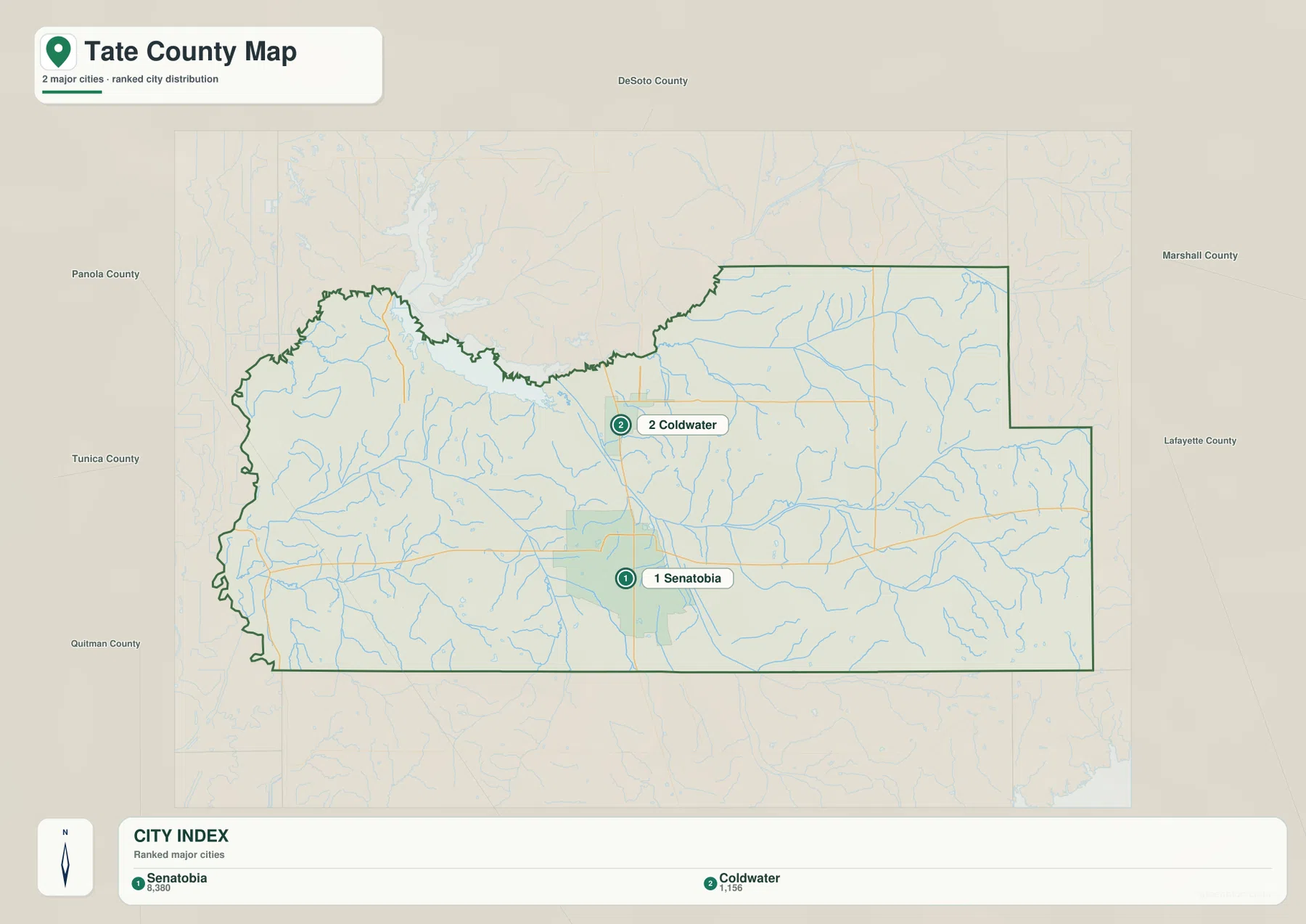
The ranked city map is simple: Senatobia is shown at 8,380 residents and Coldwater at 1,156. That two-city ranking is helpful for seeing Senatobia’s much larger scale relative to Coldwater, while the countywide population figure remains a separate measure. The general county map adds Independence, Arkabutla, and Strayhorn, which are important location references even though they are not included in the two-city ranking.
Reading the Tate County Mississippi map
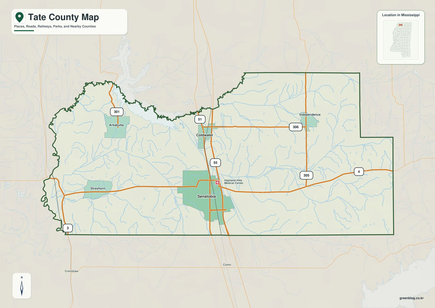
I-55 is the strongest road reference on the general county map. It enters from the Panola County side, passes just east of Senatobia, continues through Coldwater, and then heads toward DeSoto County. US 51 follows a similar north-south relationship and helps connect the same two cities at a county scale. Once Senatobia and Coldwater are located, the rest of the road pattern becomes much easier to interpret.
MS 4 crosses Senatobia from west to east, linking the Strayhorn and Tunica County direction with Independence and the Marshall County side. MS 305 runs through the northeastern interior, and MS 306 crosses the Independence area. MS 301 appears near Arkabutla in the northwest, while MS 3 is visible near the western edge. A simpler way to orient the road map is to follow I-55 and US 51 north-south through the county, then use MS 4 through Senatobia to understand the main east-west movement.
The map also labels Highland Hills Medical Center near Senatobia, reinforcing the city’s role as a service center. Coldwater lies to the north, Independence to the northeast, Arkabutla to the northwest, and Strayhorn to the west. This arrangement shows a county with one dominant administrative center but several smaller communities distributed along different roads and terrain zones.
The city map removes much of the road and terrain detail and focuses on Senatobia and Coldwater. Senatobia appears in the south-central area, with Coldwater north of it along the I-55-US 51 corridor. Surrounding county labels include DeSoto, Marshall, Lafayette, Panola, Tunica, and Quitman, which makes it easy to place Tate County within northern Mississippi. Its stripped-down layout works best when the goal is to compare where Senatobia and Coldwater sit within Tate County, not to choose a turn-by-turn driving route.
Boundary, Water, and Terrain
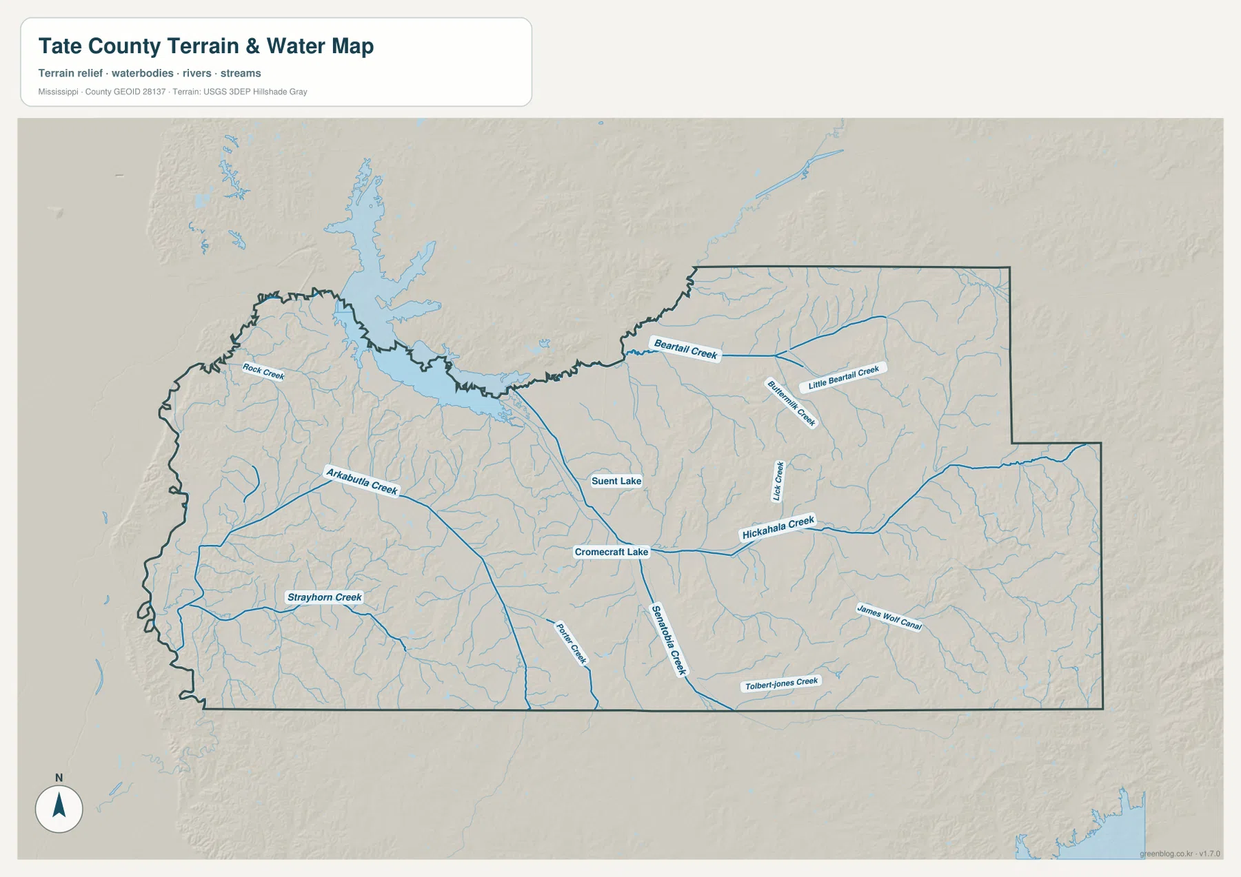
Arkabutla Lake is the largest water reference in the northwestern part of the supplied terrain-and-water map. The lake extends beyond the county’s northern side, so it should not be treated as a water body contained entirely within Tate County. Arkabutla Creek runs below the reservoir, while Rock Creek and Strayhorn Creek occupy separate western drainage lines. Their valleys are part of the lower terrain visible in the western and central sections of the elevation map.
Hickahala Creek is one of the strongest named channels across the central-eastern area. Beartrail Creek and Little Beartrail Creek appear farther northeast, with Buncombe Creek and Lick Creek nearby. Senatobia Creek runs through the south-central portion, while James Wolf Canal and Tolbert-Jones Creek are labeled farther southeast. Suent Lake and Cronecraft Lake provide smaller inland waterbody references among the creek valleys.
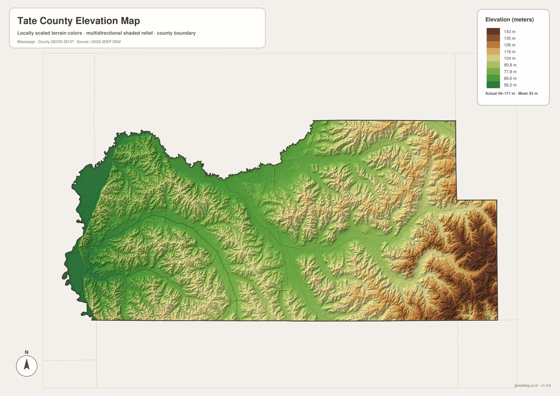
The elevation map prints an actual range of about 49 to 171 meters and a mean elevation of about 93 meters. Broad green low ground crosses the center, and the Arkabutla Lake side is also relatively low. Moving east and southeast, tan and brown ridges become more common, with the strongest high terrain concentrated in the southeastern part of the county. The northeast also contains many narrow ridges and valleys, producing a much rougher surface than the central corridor.
Comparing the water and elevation maps explains much of this pattern. Hickahala Creek and Senatobia Creek occupy lower corridors between higher ridges, and the same relationship appears around Arkabutla and Strayhorn creeks in the west. The elevation colors are intended to compare Tate County’s broad valleys and ridges; parcel elevations, drainage engineering, construction work, and flood decisions require more precise source data.
Settlement and Regional Context
Senatobia is the county seat and the largest city in the supplied ranking. Its position near I-55, US 51, and MS 4 makes it the natural reference point for travel toward Coldwater, Independence, Strayhorn, and the neighboring counties. The existing material also identifies Northwest Mississippi Community College in Senatobia, reinforcing the city’s role as an educational and service center for the surrounding rural area.
Coldwater is smaller but geographically important because it sits closer to the DeSoto County and Memphis direction. Neither Coldwater nor Senatobia is part of the City of Memphis. They are independent Mississippi communities, although the I-55 corridor gives them practical transportation and economic connections to the larger metropolitan area to the north.
Arkabutla Lake is the strongest natural reference for the northwestern side of the county. The supplied material and U.S. Army Corps of Engineers link indicate that the reservoir and managed recreation lands extend across the Tate-DeSoto county area. The maps on this page are useful for understanding the overall shoreline, nearby roads, and terrain, but exact recreation boundaries and access rules should be checked with the official lake source.
Practical Map Uses
Use the general county map when the boundary, I-55, US 51, Senatobia, Coldwater, Independence, and other place names need to appear together. The city map is better for a simple comparison of Senatobia and Coldwater. Choose the water map when Arkabutla Lake, Hickahala Creek, Senatobia Creek, or the smaller lakes are the main subject. The elevation map is the clearest option for showing the low central corridor against the higher eastern and southeastern hills.
In a classroom or presentation, placing the road map beside the elevation map makes it easy to show how the Senatobia-Coldwater corridor crosses lower central ground while higher hills rise farther east. For physical geography, the water view and elevation view complement each other particularly well around Arkabutla Lake, Hickahala Creek, and Senatobia Creek because the stream corridors line up with many of the lower green valleys.
The WebP versions in the article are sized for quick on-page viewing. For an A3 print, a cropped graphic, or work in an image editor, the JPG originals in the archive provide the more useful source files. Use these maps for county-scale orientation and comparison. Property boundaries, flood zones, engineering measurements, Arkabutla recreation rules, and current driving conditions should be checked with the appropriate up-to-date official source.
Frequently Asked Questions
Is Arkabutla Lake entirely in Tate County?
No. The package references and the official lake source both show Arkabutla as a cross-county feature associated with the Tate-DeSoto area rather than a reservoir confined to Tate County. The water view is useful for locating the Tate County shoreline and nearby creeks, while the U.S. Army Corps of Engineers remains the better source for exact recreation areas and managed boundaries.
What geographic context does Arkabutla Lake provide from Senatobia toward DeSoto?
From Senatobia, Arkabutla Lake provides a large northwestern water and terrain reference toward the DeSoto County side. It helps distinguish the lower lake-and-creek country from the higher eastern hills, but exact routes, recreation access, and shoreline jurisdiction still require specialized current maps.
Map File Information
The ZIP contains the Tate County county, city, water, and elevation maps as high-resolution A3 JPG files. Compared with the page previews, the JPG files give more room for labels and linework when printing, preparing a lesson, or placing a Tate County map into another graphic.
- File Type: four high-resolution JPG files in one ZIP
Related Maps
Sources
- U.S. Census Bureau QuickFacts for Tate County — population reference
- U.S. Census Bureau Gazetteer Files — land and water area reference
- Mississippi Department of Transportation Official Highway Map — I-55, US 51, and state-route reference
- U.S. Army Corps of Engineers Arkabutla Lake — lake and recreation-area reference
- USGS National Hydrography — creek and waterbody reference
- USGS 3D Elevation Program — elevation and terrain reference
Green Map creates custom-edited map images using open geographic data sources such as geoBoundaries, Natural Earth, OpenStreetMap, and government open data. These maps are edited visual materials, not raw data files, and are provided for education, documents, presentations, and graphic reference.