This page provides downloadable Tishomingo County map files for readers who need county-scale road, city, water, and elevation references. Iuka and Burnsville anchor the northern US 72 corridor, while Tishomingo, Belmont, Golden, and Paden extend the settlement pattern southward. Pickwick Lake dominates the northeast, Bay Springs Lake appears farther southwest, and a dense network of creeks runs through the wooded hills between them. The elevation surface shows an actual county range of about 100 to 244 meters. High-resolution A3 JPG originals for all four supplied map subjects are packaged in the ZIP below.
Tishomingo County occupies the northeastern corner of Mississippi, touching Tennessee to the north and Alabama to the east. That border position matters, but the county’s physical geography is even more distinctive. It is long from north to south, broken by steep-looking ridges and narrow valleys, and framed by large water bodies at opposite ends. Iuka is the administrative and northern travel reference, while Belmont and Golden help define the southern end. Reading the road map beside the water and elevation maps makes the county’s shape and terrain much easier to understand.
Table of Contents
Iuka, six mapped communities, and the county’s long shape
The population material included in the package lists 18,850 residents in the 2020 census and a July 2025 estimate of 18,639. Because the two figures come from different reference dates and estimation methods, they are most useful as separate benchmarks for the county’s recent size. The 2025 Gazetteer values list 424.297 square miles of land and 20.222 square miles of water. Dividing the 2020 count by the listed land area gives about 44.4 residents per square mile, but settlement is clearly not spread evenly across towns, reservoirs, forest, and hill country.
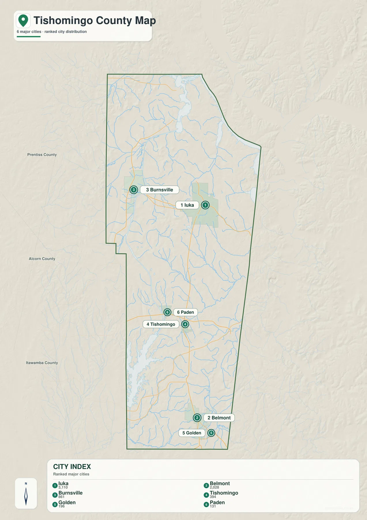
The city map ranks six communities. Iuka is shown at 3,110 residents, Belmont at 2,028, Burnsville at 861, Tishomingo at 394, Golden at 196, and Paden at 131. The ranking helps compare the selected places without confusing them with the total county population. Iuka and Burnsville sit in the north, Tishomingo and Paden occupy the middle-south, and Belmont with Golden anchors the far southern end.
That distribution reveals how elongated the county is. A reader moving from Iuka toward Belmont and Golden is following almost the full north-south length of Tishomingo County. Alcorn, Prentiss, and Itawamba counties lie to the west and southwest, while Tennessee and Alabama form the outer state-border context. The city map is therefore especially useful for orientation: it shows that northern Iuka and southern Belmont belong to the same county even though a long stretch of wooded terrain separates them.
US 72 in the north and MS 25 down the county
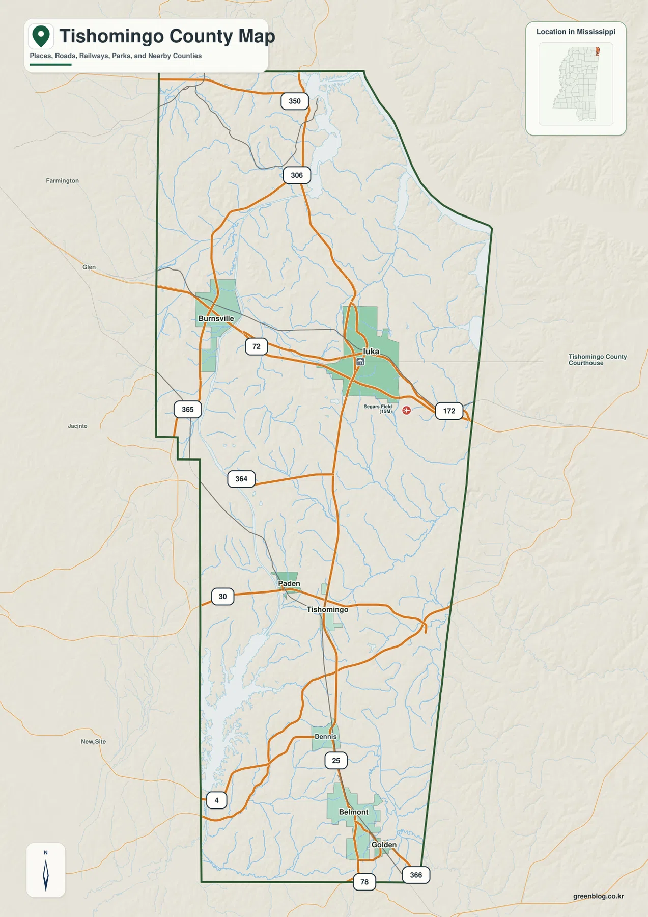
US 72 is the clearest road reference in the northern third of the general county map. It enters from the Alcorn County side, passes Burnsville, continues through the Iuka area, and then heads toward Alabama. MS 25 turns south from the Iuka corridor and becomes the most useful route for following the county toward Tishomingo and Belmont. Together, those two roads explain much of the basic travel geometry without requiring a reader to memorize every state-route number.
Several other roads add detail. MS 350 and MS 306 serve the northern interior, MS 365 is labeled near Burnsville, and MS 172 runs east from the Iuka side. MS 364 crosses the middle of the county. Near Tishomingo, MS 30 heads west toward Prentiss County, while MS 4, MS 78, and MS 366 help define the southern network around Belmont and Golden. The map simplifies local lanes and forest access roads, so it is intended for regional orientation rather than turn-by-turn navigation.
The Tishomingo County Courthouse is labeled in Iuka, along with a medical facility, which helps identify the city’s center. Burnsville, Tishomingo, and Belmont are also drawn as distinct settlement areas rather than isolated labels. Around lakes and waterway corridors, however, recreation roads and managed access may differ from ordinary public roads. Anyone traveling to a marina, boat ramp, park, or forest access point should check the current managing-agency information.
From Pickwick Lake to Bay Springs Lake through a creek-cut landscape
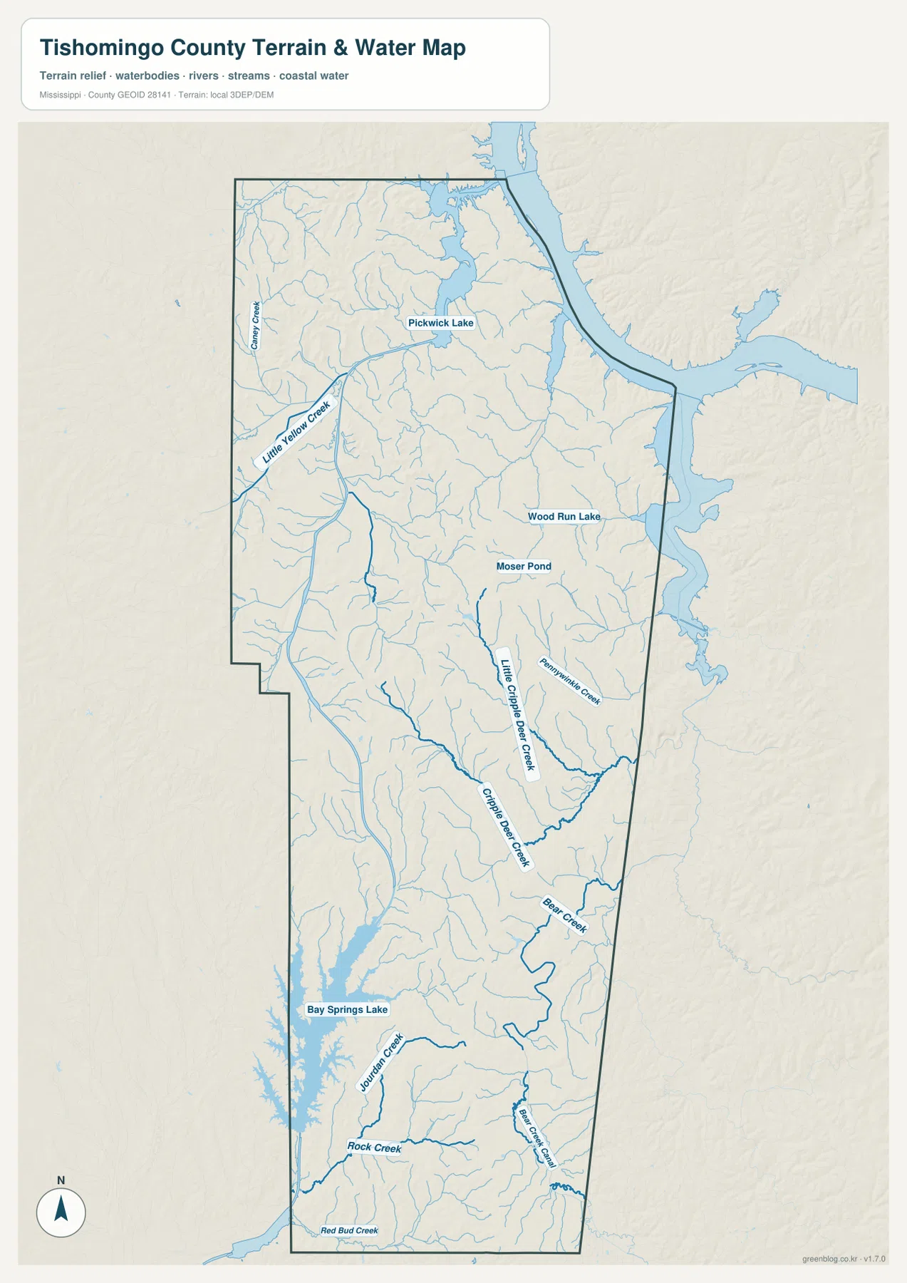
Pickwick Lake is the dominant water feature in the northeast. Its broad water surface and connected channels occupy the corner where Mississippi approaches Tennessee and Alabama, and short tributary valleys descend into the lake from the surrounding hills. Little Yellow Creek is labeled farther west in the northern part of the county, along with many smaller streams that are easier to see on the terrain-and-water map than on the road map.
The central section contains smaller water references such as Wood Run Lake and Moser Pond. Long creek valleys continue southward, including Little Cripple Deer Creek and Chapel Deer Creek on the supplied map. Farther south, Bear Creek becomes a stronger named channel. Around Bay Springs Lake, Journey Creek and Rock Creek enter a different set of valleys that drain toward the large southwestern water body.
Bay Springs Lake appears as a long, narrow reservoir along the southwest side. The source material connects this area with the Tennessee-Tombigbee Waterway, but Pickwick Lake and the Tenn-Tom system should not be treated as a single lake with one name. Natural channels, reservoirs, navigation cuts, and managed waterway segments interact in this region. For boating routes, navigation limits, or exact waterway boundaries, the U.S. Army Corps of Engineers map set is more appropriate than this general county view.
Viewed as a whole, the water map shows two large water areas at different ends of the county with a dense web of small streams between them. That arrangement explains why Tishomingo County looks so different from a broad flat floodplain county. Water is repeatedly confined by ridges and narrow valleys before reaching larger lakes and channels, and the elevation map makes those landforms even more obvious.
A 100–244 meter landscape of ridges, valleys, and Woodall Mountain
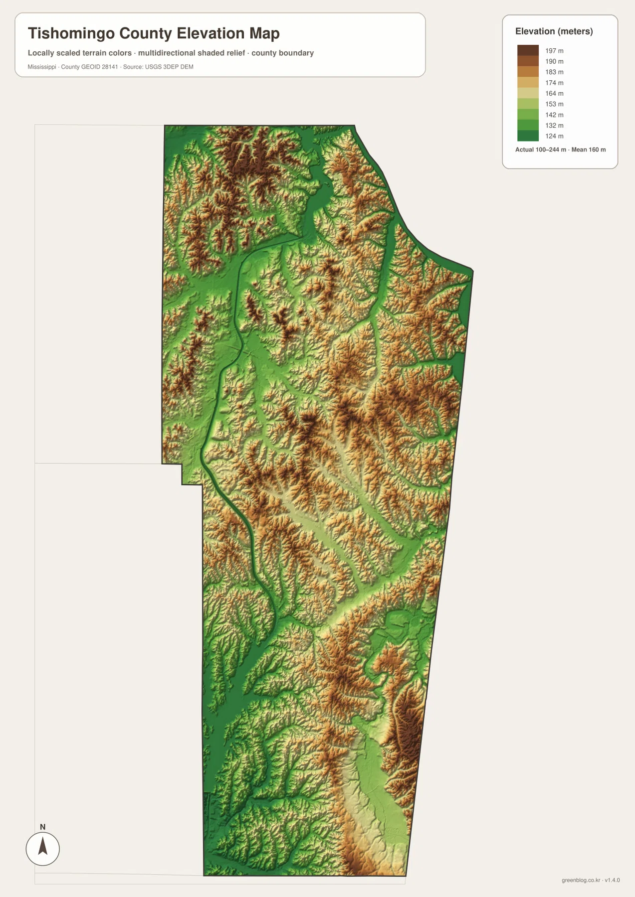
The elevation map prints an actual range of about 100 to 244 meters and a mean of about 160 meters. Brown and orange high ground is especially dense in the northwest and northeast, where narrow green valleys cut between closely spaced ridges. The Iuka-Pickwick area is therefore not one flat urban plain; the town, lake approaches, and tributaries sit among repeated rises and depressions. Compared with many lowland Mississippi counties, the relief is immediately visible.
A long lower corridor runs through parts of the center, and several roads and streams follow or cross that easier terrain. East-central and southeastern sections become rougher again, with high ridges separated by branching creek valleys. Around Bay Springs Lake, broad low water and valley surfaces contrast strongly with higher land on either side. The southern end also contains a mix of ridges and low drainage channels, so the county cannot be summarized as simply higher in the north and lower in the south.
The existing package identifies Woodall Mountain as Mississippi’s highest point, which makes it a useful regional landmark when discussing the county’s uplands. The elevation map on this page is not a summit-access or hiking map, however. It shows countywide relief rather than the exact route to the high point, legal access, or ownership. For those details, readers should use a dedicated current topographic or land-management source.
Iuka and Belmont as northern and southern reference points
Iuka is the county seat, the largest city in the supplied ranking, and the most convenient starting point for understanding the northern road network. US 72 connects it with Burnsville and Alabama, while MS 25 begins the long route toward the southern communities. Pickwick Lake is also closest to the Iuka side of the county, making the city useful for explaining both transportation and the northeastern water landscape.
Belmont provides a different reference in the south. It is the second-largest city shown on the city map, with Golden nearby to the southeast and Tishomingo farther north. Paden is a smaller community northwest of Tishomingo. The southern half is not a continuous urban strip; these towns are separated by wooded hills, stream valleys, and stretches of rural road, which is why the elevation and water maps add important context to the settlement map.
The existing source material also mentions Tishomingo State Park and the Natchez Trace Parkway as southern travel references. The maps here are not detailed park or tourism maps, but those places help explain why the Tishomingo-Belmont side is important beyond local settlement. Current park hours, trail conditions, campground access, and road information should be checked with the relevant managing agency.
Choosing the map that answers the question
Use the general county map when Iuka, Burnsville, Tishomingo, Belmont, roads, and the county boundary need to appear together. The ranked city map is better for a clean comparison of the six selected communities. The water map is the strongest choice for Pickwick Lake, Bay Springs Lake, Bear Creek, and the intervening drainage network. The elevation view is the clearest way to explain how narrow valleys separate the county’s high ridges.
For classroom or presentation work, the road and elevation maps make a useful pair because the US 72-MS 25 route pattern can be compared directly with the hill country underneath. For physical geography, place the water and elevation maps side by side: the low lake and creek corridors align with green valleys, while the brown ridges explain why the water network branches so densely.
The WebP images in the article are designed for quick page viewing. For A3 printing, cropping, or editing, the JPG originals in the archive provide the larger source files. These maps are general geographic references rather than parcel surveys, navigation charts, flood maps, hiking-access guides, or live road products, so specialized current sources are still needed for those decisions.
Frequently Asked Questions
Is Woodall Mountain the highest point in Mississippi?
The existing material supplied with this package identifies Woodall Mountain as Mississippi’s highest point. The county elevation map also shows that Tishomingo County contains substantial high ground, with an actual mapped range of about 100 to 244 meters. A dedicated topographic or access source is still better for the exact summit position and route information.
Are Pickwick Lake and the Tennessee-Tombigbee Waterway the same body of water?
No. The package material treats Pickwick Lake and the Tennessee-Tombigbee Waterway as connected parts of the broader regional navigation landscape, not as one lake with a single name. Reservoirs, navigation cuts, canals, and natural channels should be distinguished with the U.S. Army Corps of Engineers’ detailed waterway maps when navigation or exact boundaries matter.
Map File Information
The ZIP contains the Tishomingo County county, city, water, and elevation maps as high-resolution A3 JPG files. Compared with the WebP previews, the originals preserve more room for labels and terrain detail when printing, editing, or preparing classroom graphics.
- File Type: four high-resolution JPG files in one ZIP
Related Maps
Sources and References
- U.S. Census Bureau QuickFacts for Tishomingo County — population reference
- U.S. Census Bureau Gazetteer Files — land and water area reference
- Mississippi Department of Transportation Official Highway Map — US 72, MS 25, and state-road reference
- U.S. Army Corps of Engineers Tennessee-Tombigbee Waterway maps — navigation and waterway reference
- USGS National Hydrography — creek and waterbody reference
- USGS 3D Elevation Program — elevation and terrain reference
Green Map creates custom-edited map images using open geographic data sources such as geoBoundaries, Natural Earth, OpenStreetMap, and government open data. These maps are edited visual materials, not raw data files, and are provided for education, documents, presentations, and graphic reference.