Coke County in west-central Texas is defined by a striking combination of two small towns, a large reservoir, the Colorado River, and deeply dissected rolling terrain. Robert Lee lies slightly west of the county center, close to the eastern end of E.V. Spence Reservoir, while Bronte sits farther east along State Highway 158. The county map also shows Blackwell beyond the northeastern side and Tennyson near the southeast, helping place Coke County within the wider region. The water map adds E.V. Spence Reservoir, Mountain Creek Reservoir, Rough Creek, Pecan Creek, and the Colorado River, while the elevation surface ranges from about 519 to 797 meters with a mean near 647 meters. The four matching county, city, water, and elevation maps are available as high-resolution JPG files in a single ZIP download.
Robert Lee and Bronte are the easiest places to establish orientation. State Highway 158 connects them directly across the middle of the county, but the land between the two is not an uninterrupted flat corridor. Reservoir arms, creek valleys, and ridges occupy much of the open space. Robert Lee is closely tied to the reservoir landscape, whereas Bronte is farther east near the Colorado River system and a different group of tributaries. The city map reduces the view to those two communities, and the physical maps then show what fills the wide rural area around them.
Table of Contents
State Highway 158 Links Robert Lee and Bronte Across the County
State Highway 158 is the clearest transportation line on the general county map. It approaches Robert Lee from the west, passes through the town, and continues east toward Bronte. Local roads branch north and south around Robert Lee, while Bronte has its own connections toward the northern and southern parts of the county. Because the two built-up areas are small and widely separated, Highway 158 becomes the most practical line for understanding their relationship.
Several outside and edge-of-county references help complete the picture. Route 70 and Blackwell appear beyond the northeastern side, Route 384 is marked east of Bronte, and Tennyson with Route 277 lies toward the southeast. A long Route 10 corridor is visible in the south-central area, while Route 87 appears near the southwestern side. These roads show that the county is connected in several directions even though Robert Lee and Bronte remain the only ranked major cities on the supplied city map.
Robert Lee’s road setting is strongly influenced by E.V. Spence Reservoir. The water body lies immediately west and northwest of town, and local roads bend around reservoir arms and nearby valleys. Bronte is not on the reservoir shoreline, but the Colorado River and multiple tributaries occupy the landscape to its south and west. Highway 158 may look like a simple east-west route, yet the water and elevation layers reveal a much more irregular physical setting on both sides.
The northern and western parts of the county contain fewer major road labels and many more small drainage lines. Much of the south is also open rural terrain rather than continuous settlement. Coke County therefore reads poorly as a simple highway map alone. The road pattern becomes more meaningful once the reservoir, Colorado River valley, and high western ridges are added.
Bronte 1,041 and Robert Lee 946 on the Ranked City Map
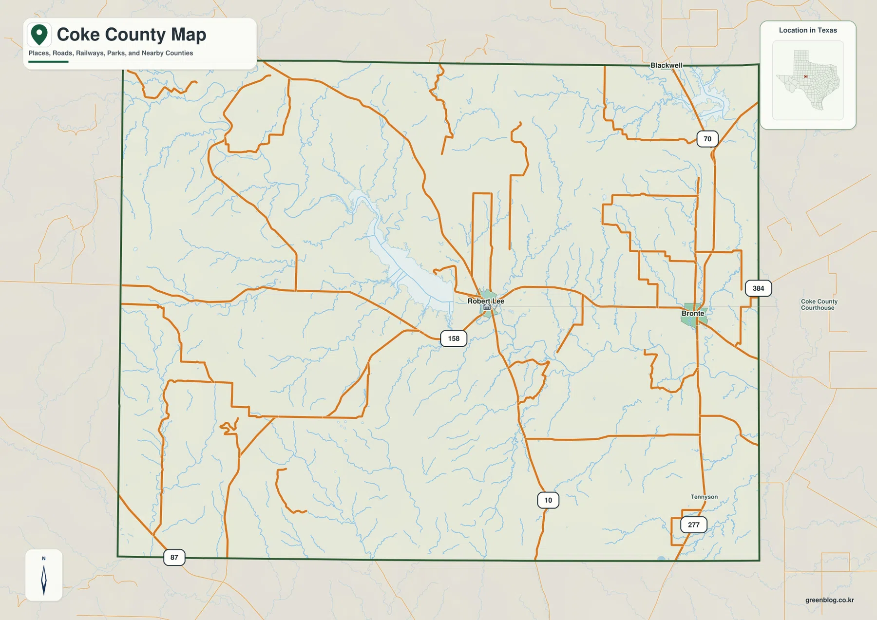
The supplied ranked city map contains only two major cities. Its CITY INDEX lists Bronte first at 1,041 and Robert Lee second at 946. The values are relatively close, so the strongest difference on the map is geographic rather than numeric. Robert Lee occupies the western-central part of the county near the reservoir, while Bronte is much closer to the eastern boundary.
The simplified city layer also makes the neighboring counties easy to locate. Nolan County and Mitchell County are shown to the north, Runnels County to the east, Sterling County to the west, and Tom Green County toward the southwest. Robert Lee is visually closer to the broad western and southwestern interior, while Bronte is positioned near the Runnels County side. This distribution helps explain why the two towns serve different sides of such a wide rural county.
No connector line or mileage label appears between the two cities, so 1,041 and 946 should not be read as distances. They are the values printed on the supplied city index and should not be treated as a current population estimate without separate demographic verification. For actual travel, the general county map provides the relevant highway line; for the land between the towns, the water and elevation maps are far more informative.
The large blank areas on the city map are especially revealing after the other maps are considered. They are not empty landscape. Much of western Coke County is broken into high ridges and creek valleys, while the central county contains the reservoir and Colorado River drainage. The city layer is therefore best used to establish settlement spacing before moving to the more detailed physical maps.
E.V. Spence Reservoir Feeds into the Colorado River Valley
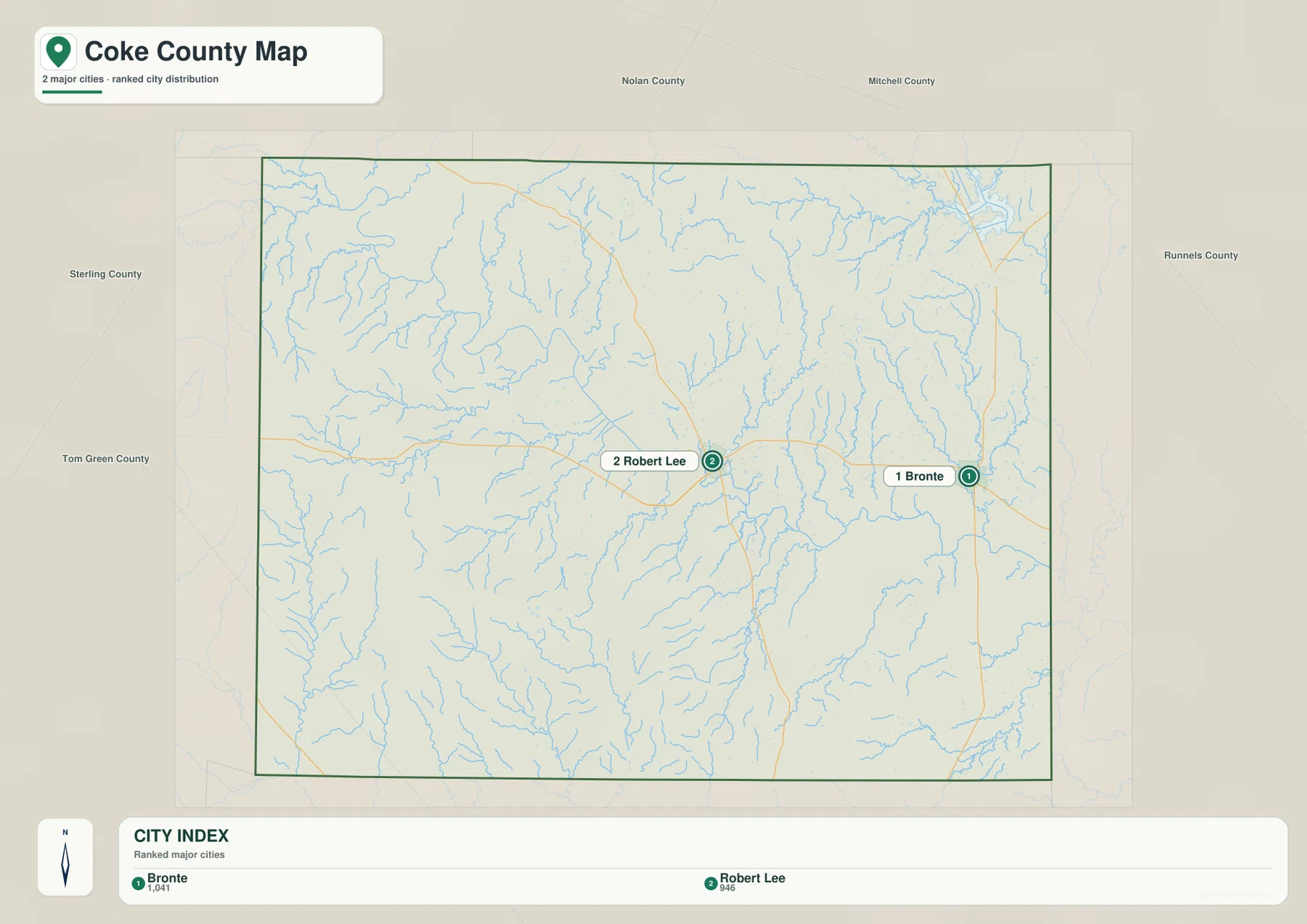
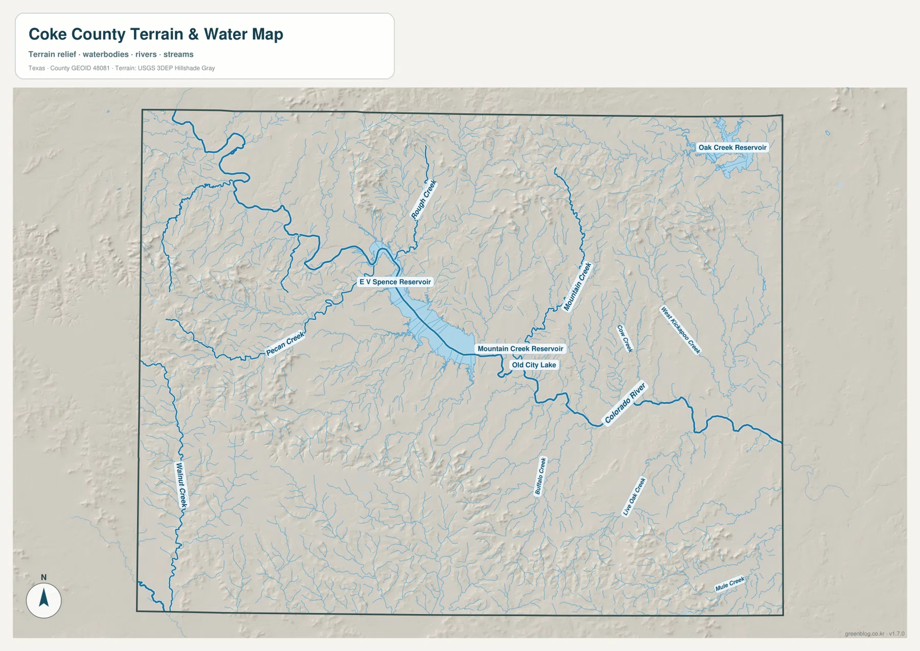
E.V. Spence Reservoir is the dominant water feature on the terrain-and-water map. It extends from the western side toward the center of the county, narrowing near Robert Lee before the Colorado River continues east and southeast. The reservoir shoreline is highly irregular, with numerous coves and tributary arms. This makes the Robert Lee area one of the clearest places in Coke County for seeing how settlement, roads, and water occupy the same narrow valley system.
Rough Creek approaches from the north, while Pecan Creek and Walnut Creek occupy long western and southwestern valleys. Farther east, Mountain Creek descends toward Mountain Creek Reservoir and Old City Lake before reaching the larger Colorado River drainage. These smaller named features provide practical landmarks for understanding the otherwise dense network of blue tributaries on the map.
The northeastern side includes Oak Creek Reservoir near the county edge, with West Kickapoo Creek and Coke Creek visible farther south and west. In the southern half, Paint Creek, Live Oak Creek, and Mule Creek occupy separate drainage corridors. The result is a county whose water geography cannot be reduced to the Colorado River alone. Small creeks begin in the surrounding uplands and converge toward reservoirs or the main river valley.
The relationship becomes especially clear when the water layer is compared with elevation. Rough Creek and Pecan Creek follow lower corridors between high northern and western ridges, while the Colorado River occupies a broad low route through the center and east. This map is intended for general geographic reference, not flood-hazard assessment, parcel boundaries, water depth, water quality, or navigation.
Elevation from About 519 to 797 Meters Separates Western Uplands from the River Valley
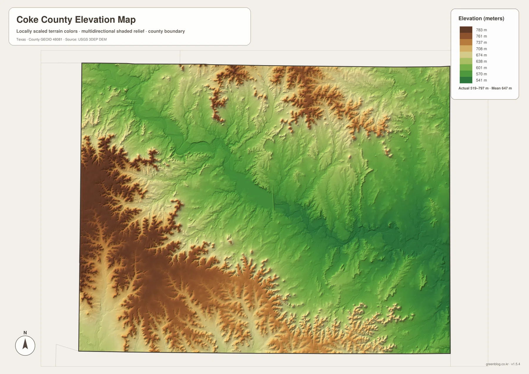
The supplied elevation map reports an actual range of approximately 519 to 797 meters and a mean near 647 meters. A difference of almost 280 meters is substantial at county scale. The highest brown terrain is concentrated in the west and southwest, with additional high ridges across the north-central portion. The E.V. Spence Reservoir and Colorado River corridor forms a much lower green band through the middle of the map.
The western high country is not a smooth plateau. Deep valleys cut through the brown ridges, especially where Pecan Creek and Walnut Creek descend toward the reservoir system. As those valleys approach E.V. Spence Reservoir, elevation drops quickly. The water map confirms that the most obvious low corridors correspond to named drainage lines rather than arbitrary color changes.
The north-central part of Coke County also contains pronounced relief. Rough Creek and its tributaries cut green valleys through high ridges, producing a strongly dissected surface. Elevations generally become lower toward the east, where the Colorado River and Bronte-side drainage occupy broader valleys. The southeast remains lower than the southwestern uplands, although numerous small ridges prevent the county from sloping smoothly in one direction.
This elevation surface is suitable for county-scale comparison, not survey or engineering measurement. It should not be used to determine the precise elevation of a house, parcel corner, road grade, or construction site. The 519–797 meter range and 647 meter mean are best treated as broad reference values that show how strongly the western uplands, creek valleys, reservoir, and Colorado River differ in elevation.
Robert Lee Shows the Road–Reservoir–Relief Relationship Most Clearly
Robert Lee is the most useful point for comparing all of the supplied map layers. On the county map, State Highway 158 and several local roads converge there. On the water map, E.V. Spence Reservoir lies immediately to the west and northwest. On the elevation map, the reservoir and town occupy lower terrain than the high ridges farther southwest. The same location therefore connects transportation, settlement, water, and relief in a way that is easy to follow.
Moving east from Robert Lee toward Bronte changes that setting. The reservoir disappears from view, but the Colorado River and Mountain Creek system remain important. The city map leaves a wide open gap between the two towns, while the physical maps fill that gap with tributaries and ridges. This is one of the strongest reasons to use the map set together rather than relying only on the ranked city layer.
The southwest provides the opposite extreme. Settlement labels are sparse, but high relief is extensive and Pecan Creek and Walnut Creek cut deep valleys through the uplands. The northeast and east are generally lower and contain broader drainage corridors. Coke County therefore changes visibly from rugged western uplands to the reservoir-and-river system and then toward lower eastern terrain.
Choosing the Best Coke County File for Roads, Water, or Relief
The general county map is the best single reference for Robert Lee, Bronte, State Highway 158, and the surrounding road network. The ranked city map is cleaner when the purpose is simply to compare the two communities and their positions. The terrain-and-water map is the best choice for E.V. Spence Reservoir, Colorado River, Rough Creek, Pecan Creek, and the other named water features. The elevation map most clearly explains the contrast between the high western ridges and the lower reservoir and river corridor.
Small creek labels and minor road numbers can be difficult to read in a reduced browser preview. The original JPG files are more convenient for enlargement and printing. They also work well for side-by-side comparison with Nolan, Runnels, Tom Green, Sterling, Mitchell, or other west-central Texas counties when the same map type and similar display scale are used.
The ZIP below contains four high-resolution JPG files corresponding to the county, city, water, and elevation maps shown in the article. They can be enlarged for detailed label reading, printed for classroom or personal reference, or arranged with neighboring county maps for regional comparison.
Frequently Asked Questions
How are Bronte and Robert Lee ranked on the supplied city map?
The CITY INDEX lists Bronte first at 1,041 and Robert Lee second at 946. These are the values printed on the supplied ranked-city layer and should not be interpreted as distance. State Highway 158 provides the clearest road connection between the towns on the general county map.
Where is E.V. Spence Reservoir relative to Robert Lee?
The reservoir extends west and northwest of Robert Lee. Its eastern end narrows near the town, and the Colorado River continues from the reservoir through the central and eastern county. Rough Creek and Pecan Creek are among the named tributaries visible around the reservoir system.
Which parts of Coke County are highest and lowest on the supplied elevation map?
The west and southwest contain much of the highest terrain, while E.V. Spence Reservoir and the Colorado River valley occupy lower ground. The supplied surface reports an elevation range of about 519–797 meters and a mean near 647 meters. It is intended for county-scale comparison rather than survey work.
Sources and Reference Data
- U.S. Census Bureau TIGER/Line Shapefiles — official geographic boundary, road, and place data.
- USGS National Hydrography — official information about rivers, creeks, reservoirs, and hydrography.
- USGS 3D Elevation Program — official elevation and terrain data information.
- USGS The National Map Viewer — interactive access to boundaries, transportation, hydrography, terrain, and other geographic layers.
Map File Information
Download the Coke County county, city, water, and elevation maps together as high-resolution JPG files.
- Included Files: 4 maps
- File Type: JPG
Related Maps
- Runnels County Texas map
- Sterling County Texas map
- Tom Green County Texas map
- Scurry County Texas map
- Taylor County Texas map
Green Map creates custom-edited map images using open geographic data sources such as geoBoundaries, Natural Earth, OpenStreetMap, and government open data.
These maps are edited visual materials, not raw data files, and are provided for education, documents, presentations, and graphic reference.