You can download the Jasper County Mississippi Map as a high-resolution JPG ZIP directly from this page. Bay Springs anchors the western road network, Louin and Montrose continue north along the same side of the county, and Heidelberg sits well to the southeast near a different set of routes. The maps separate county roads and boundaries, city connections, waterways, and elevation so each part of the county is easier to compare.
The county also has a landscape that is shaped more by narrow creek valleys and repeating ridges than by one large lake. The water map shows several named creeks dividing the interior, while the elevation map makes a long lower corridor through the middle stand out against higher ground to the north and east. Reading those patterns beside the road map gives a clearer picture of why settlements and highways are spread the way they are.
Table of Contents
Bay Springs anchors the western road network
On the county map, Bay Springs is the strongest settlement label on the west side, where MS 15 and MS 18 meet. MS 15 continues north toward Louin and Montrose, while MS 18 crosses the county toward the east. Heidelberg lies in the southeast near US 11, with MS 503 and MS 528 helping define the eastern and southern road pattern. Farther north, MS 504 and MS 513 show that the northeastern corner has its own approaches that are easy to miss when attention stays only on Bay Springs.
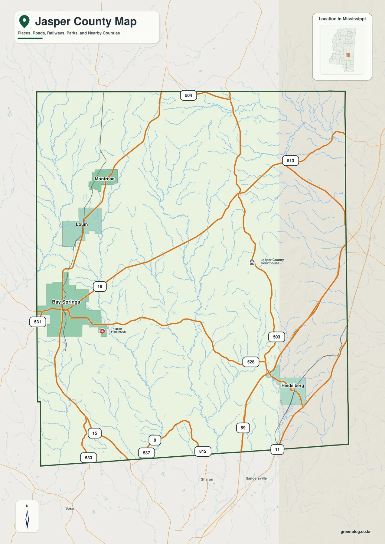
The existing article material also identifies Bay Springs and Paulding as the county’s two seat locations. Bay Springs is the more obvious urban anchor on the supplied maps, while a county courthouse symbol appears in the east-central part of the county. That combination is useful because it prevents a reader from assuming that the visible western population center is the county’s only administrative reference.
Louin and Montrose line up north of Bay Springs, while Heidelberg sits southeast
The city-connections map uses Bay Springs as the hub and makes the separation among the principal places easy to compare. Louin is shown 6 miles from Bay Springs and Montrose 10 miles away, both to the north. Heidelberg is 19 miles away in the southeast, so it belongs to a noticeably different part of the county. These are straight-line distances between mapped points, not driving distances along the road network.
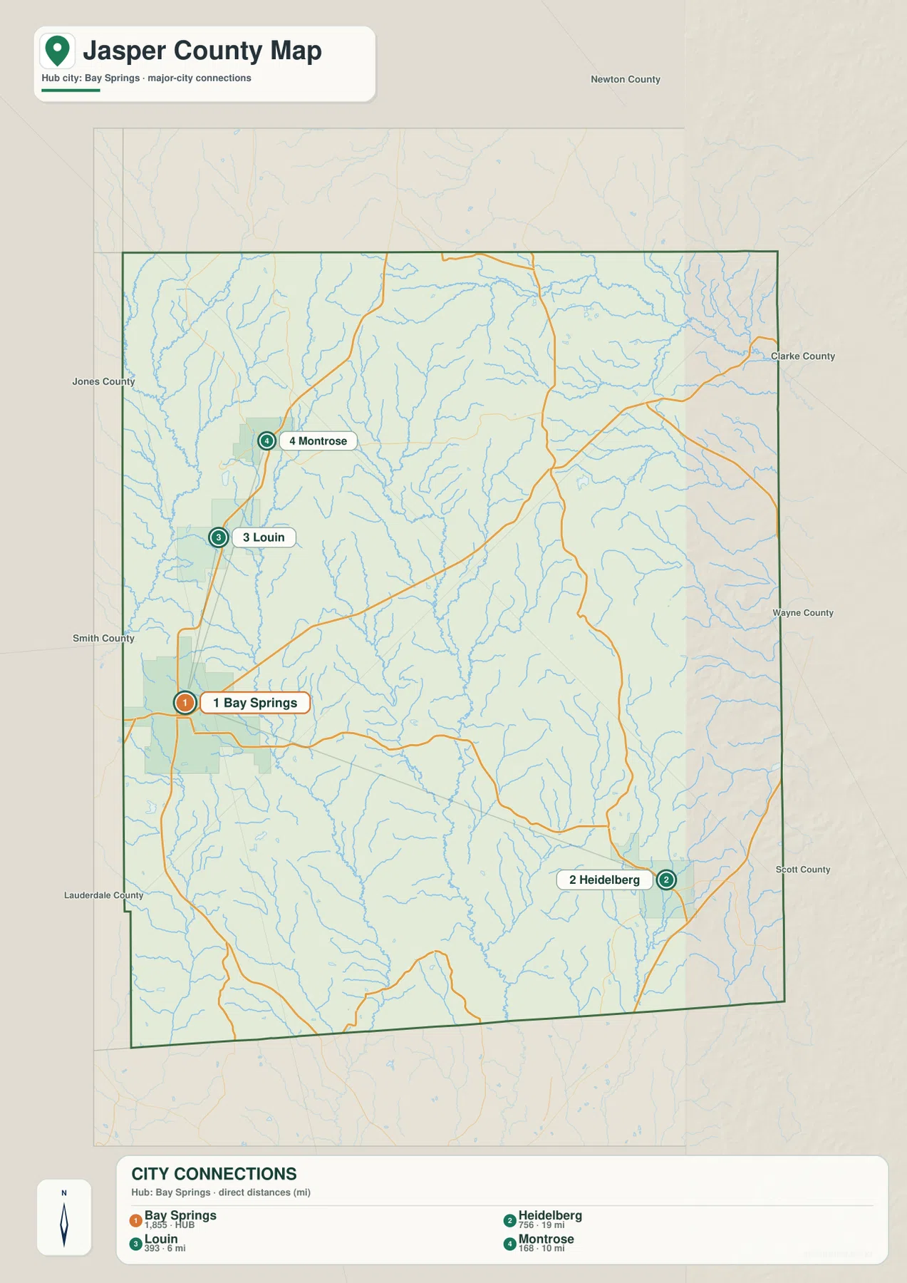
Putting the city map beside the road map explains the pattern. Louin and Montrose are close to the MS 15 corridor on the western side, so they read as a northward extension of the Bay Springs area. Heidelberg is tied more closely to the southeastern road network around MS 503 and US 11. For a classroom map, a presentation, or a simple location reference, showing the roads with the city points is more informative than listing the towns without direction.
Creek valleys divide the county more clearly than large open water
The terrain-and-water map is filled with narrow drainage lines. West Tallahala Creek marks a strong feature on the western side, while the Tallahala Creek system runs through the interior. Souenlovie Creek appears across the northern part, and Way Creek and Penantly Creek help define the eastern drainage. Smaller tributaries branch repeatedly between them, giving the county a dense, tree-like water pattern rather than a landscape organized around one dominant reservoir.
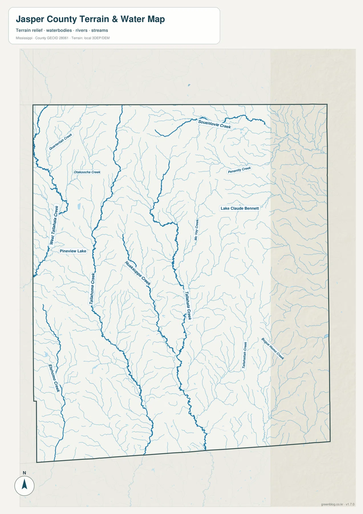
Lake Claude Bennett and Pineview Lake are visible, but they occupy only small parts of the county map. The existing county data lists 676.311 square miles of land and 1.209 square miles of water in the 2025 Gazetteer values, which fits the visual impression of many streams but little broad open water. This map is best used to locate waterways and valley directions; it is not a flood-risk, parcel, legal-boundary, or navigation chart.
A low central corridor cuts through 76–208 m ridge country
The elevation map shows a county-wide range of about 76 to 208 meters, with a mean of 116 meters. Lower green terrain forms a long corridor through the central part of Jasper County, while higher orange and brown ridges are especially strong in the north and northeast. Broken high ground also appears to the west and southeast. The result is a landscape of narrow valleys separated by repeated ridges rather than a single slope from one side of the county to the other.
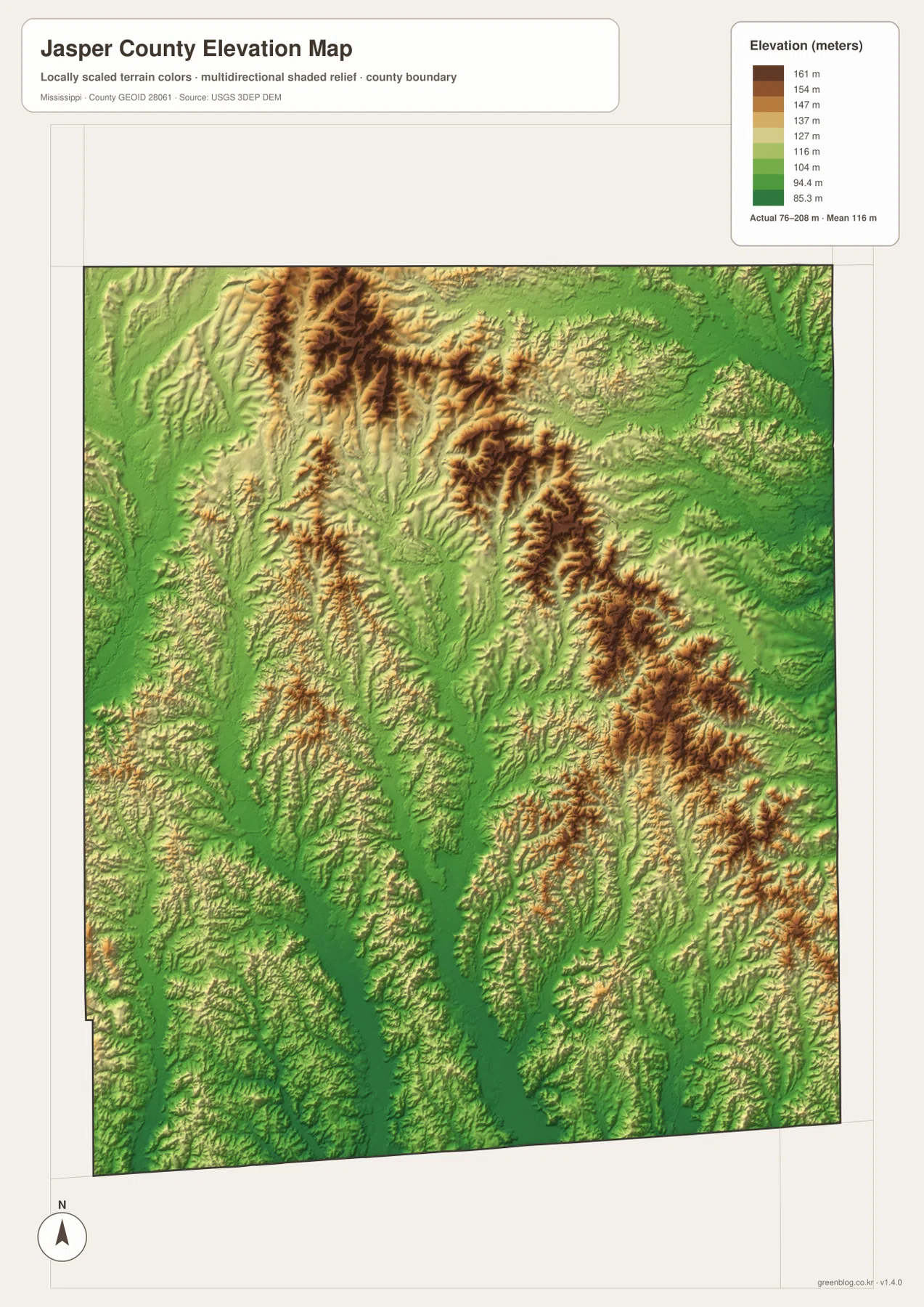
The water and elevation maps reinforce each other. Several of the stronger creek lines follow the lower corridors, while ridge crests separate one drainage from another. That relationship is more useful than simply calling the county hilly: it shows where the terrain opens into valleys and where steeper, more broken ground becomes common. The elevation surface is intended for county-scale comparison and should not be treated as survey-grade or engineering-grade elevation data.
A large rural county with widely spaced settlement points
The source material lists a 2020 census population of 16,367 and a July 2025 estimate of 15,785. Using the 676.311 square miles of land reported in the 2025 Gazetteer, the existing article gives a county-wide density of 24.2 residents per square mile for the 2020 population. That average helps explain why the map can show long stretches of roads, creeks, and wooded terrain between the larger settlement labels.
The density figure should not be read as if people were evenly spread across the landscape. Bay Springs has the clearest concentration of streets and built area, while much of the central and eastern county is visually dominated by drainage lines and ridges. Pairing the population figure with the map therefore gives a more realistic description: Jasper County has recognizable town centers, but they are separated by a broad rural interior.
Which map is most useful for your purpose?
- For roads and county orientation: use the county map to compare Bay Springs, Heidelberg, MS 15, MS 18, MS 503, MS 528, and US 11.
- For settlement spacing: use the city map to compare the straight-line distances from Bay Springs to Louin, Montrose, and Heidelberg.
- For rivers and creek valleys: use the water map to locate the Tallahala Creek system, other named tributaries, and the small lakes.
- For relief: use the elevation map to compare the lower central corridor with the higher northern and eastern ridges.
The WebP images in the article are optimized for viewing on the page. For printing, editing, or keeping an offline copy, use the download box below to get the matching high-resolution JPG maps in one ZIP archive.
Frequently Asked Questions
Why are Bay Springs and Paulding both important on a Jasper County map?
The existing county material identifies both places as county-seat locations. Bay Springs is the stronger settlement and road hub on the supplied maps, while the courthouse marker in the east-central county preserves the second administrative reference. Looking at both avoids reducing the county to its largest visible town.
Are the 6, 10, and 19 mile city-map distances driving distances?
No. They are straight-line distances from Bay Springs to Louin, Montrose, and Heidelberg. Road travel will usually be longer because a vehicle must follow the actual highway network.
What becomes clearer when the water and elevation maps are viewed together?
The lower central corridors and the major creek lines can be compared directly with the surrounding ridges. The water map is better for named drainage features, while the elevation map explains how those valleys sit between higher areas.
Map File Information
The ZIP contains the high-resolution JPG versions of the Jasper County boundary-and-road map, city-connections map, water map, and elevation map shown on this page.
- Included Files: County map, city-connections map, water map, elevation map
- File Type: JPG
Related Maps
Sources and References
- U.S. Census Bureau Jasper County QuickFacts
- U.S. Census Bureau Gazetteer Files
- Mississippi Department of Transportation official highway map
- USGS 3D Elevation Program
Green Map creates custom-edited map images using open geographic data sources such as geoBoundaries, Natural Earth, OpenStreetMap, and government open data. These maps are edited visual materials, not raw data files, and are provided for education, documents, presentations, and graphic reference.