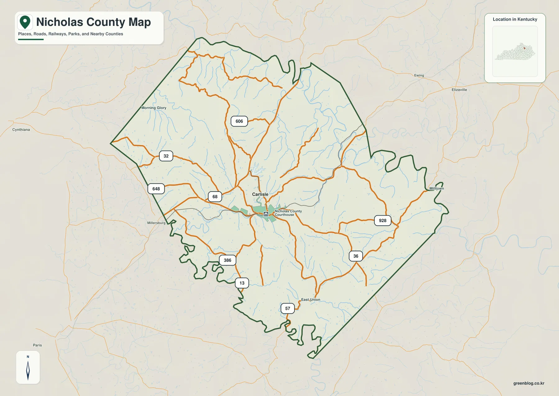
Nicholas County lies on the northeastern edge of Kentucky’s Inner Bluegrass, with Carlisle serving as the county’s main settlement and road reference. Routes 32, 36, and 68 meet around the central area, while routes 606, 648, 386, and 928 extend into the surrounding hill country. The physical maps show the Licking River, Crooked Creek, Stony Creek, Cassidy Creek, Somerset Creek, and Lake Carnico. High-resolution JPG versions of the supplied maps can also be downloaded together in one ZIP archive for printing, classroom work, presentations, or offline reference. High-resolution map files are available for download in the section below.
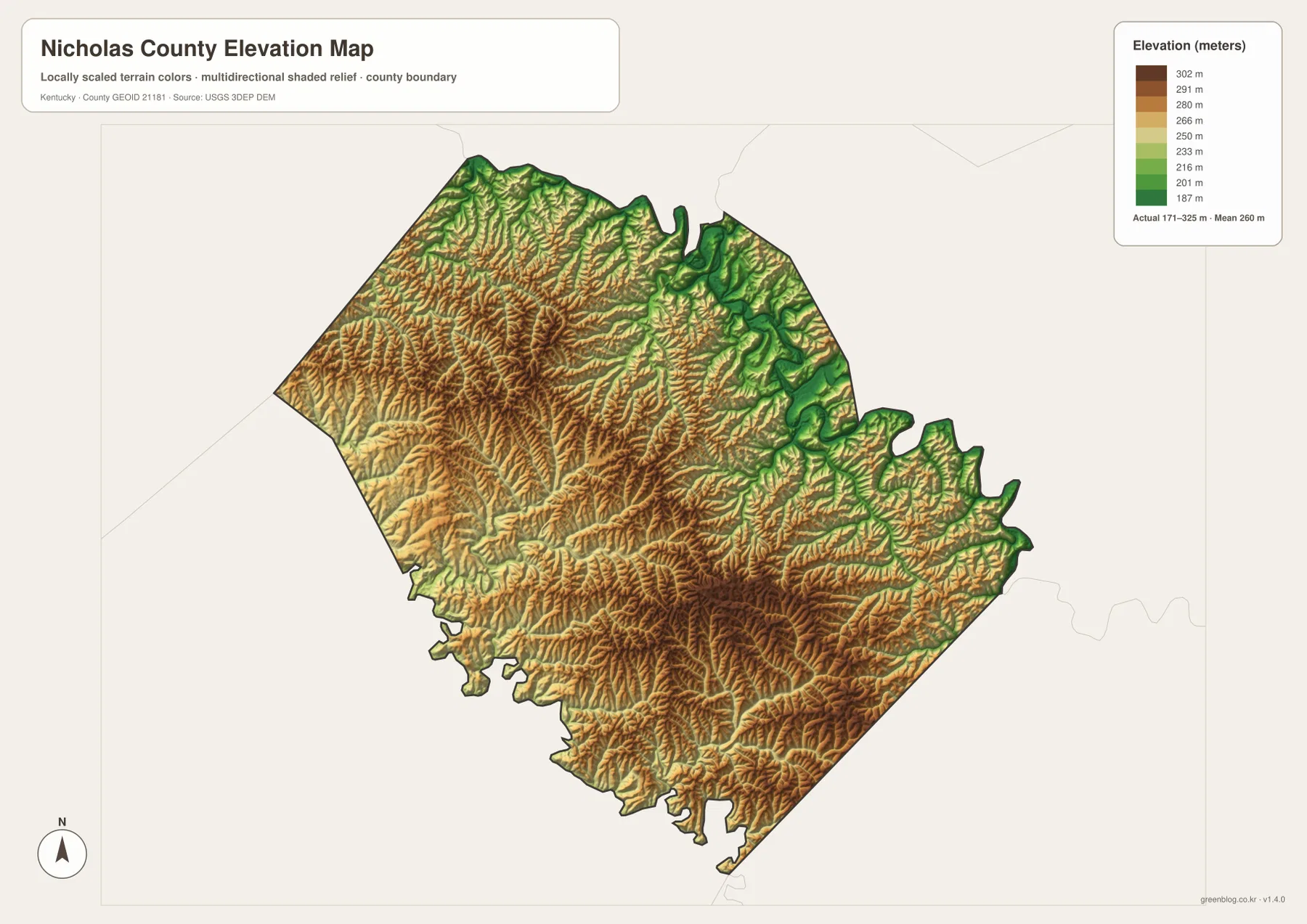
Kentucky.gov describes Nicholas County as being on the northeastern edge of the Inner Bluegrass region, and its official City of Carlisle profile identifies Carlisle as the county seat at the junction of Kentucky routes 32 and 36. The supplied elevation map adds another useful layer: actual elevations range from about 171 to 325 meters, with a mean near 260 meters. Lower river and creek corridors contrast with higher central and southern ridges.
Table of Contents
Carlisle sits at the center of routes 32, 36, and 68
The general county map makes Carlisle the easiest place to begin. Route 32 approaches from the west, route 36 continues toward the southeast, and route 68 reaches the central area from the west before connecting with the local street network. These routes give Carlisle a much denser road pattern than the outer county, where smaller roads follow the valleys between ridges.
Route 606 serves the northern interior, while route 648 reaches the western edge near Millersburg. Routes 386 and 13 help orient the southwest, and route 57 appears near the southern end around East Union. Route 928 provides an eastern reference where the road network becomes more rural.
Morning Glory appears in the northwest, Milltown near the eastern edge, and East Union toward the south. Cynthiana, Ewing, Elizaville, and Paris appear outside the county as useful regional labels. Together, these names make it easier to place Nicholas County among Harrison, Fleming, Bourbon, and neighboring counties.
This map is intended for geographic orientation rather than live navigation. It does not show current construction, closures, bridge restrictions, or travel times. Roads can curve substantially around creek valleys and hill slopes, so actual driving distance may be longer than the direct separation between two points.
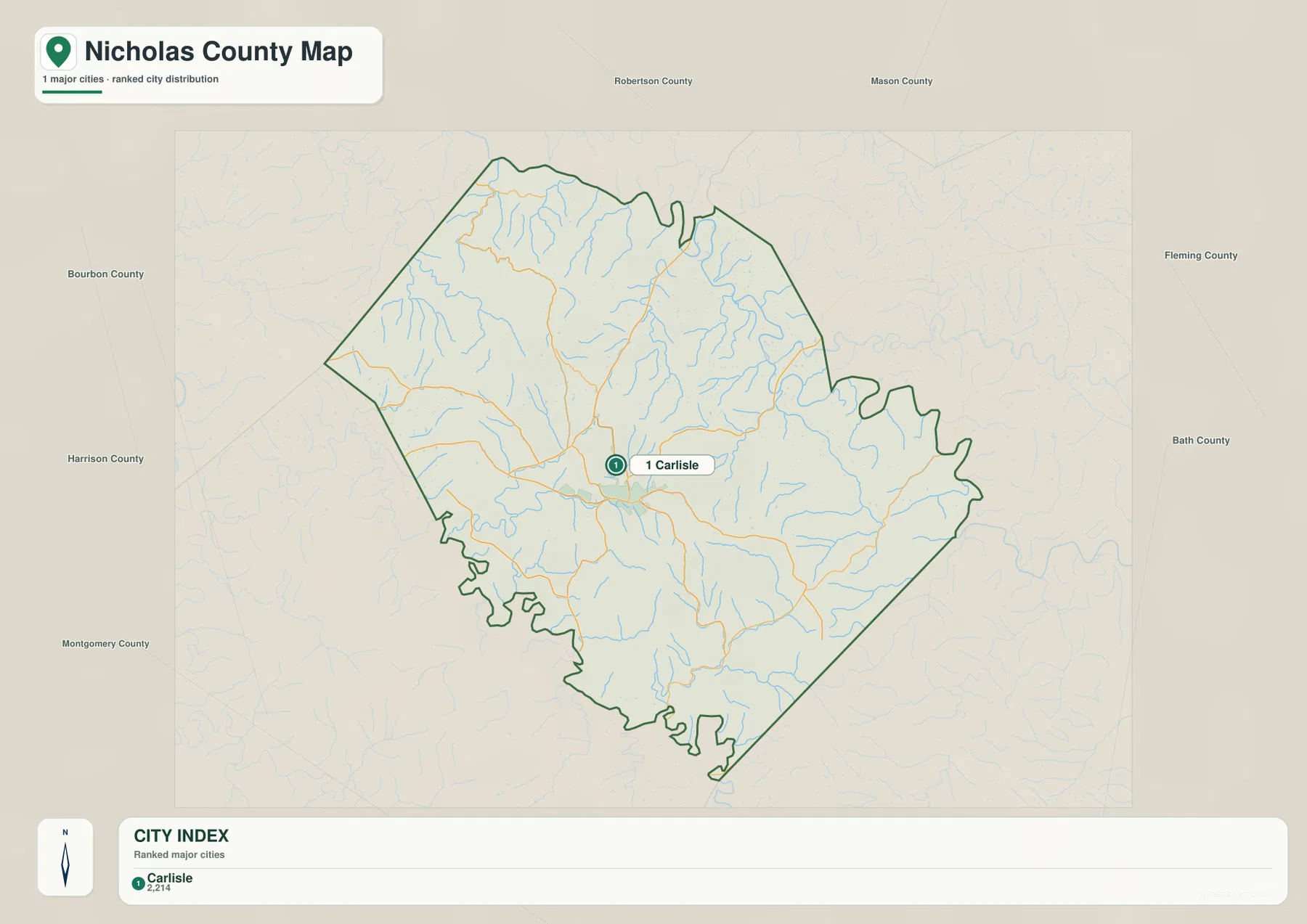
Carlisle is the only ranked major city on the supplied city map
The city-distribution map ranks Carlisle as the county’s only major city and labels its population as 2,214. That single marker stands out within a county dominated by smaller roads, streams, and rural hill country. Carlisle’s central location also makes it a practical reference when moving between the road, water, and elevation views.
Neighboring county labels include Robertson and Mason to the north, Fleming and Bath to the east, Montgomery and Harrison to the west and southwest, and Bourbon to the west. The arrangement places Nicholas County between the Inner Bluegrass and the broader Licking River region of northeastern Kentucky.
A single ranked city does not mean the rest of the county lacks named places. Morning Glory, Milltown, and East Union appear on the general road map, and Millersburg lies close to the western boundary. The city view is intentionally simplified to show settlement hierarchy, while the road map provides the finer local references.
Once Carlisle is fixed as the central point, the physical maps are easier to interpret. The Licking River bends across the north and northeast, Stony Creek runs through the central-northern interior, Lake Carnico sits west of center, and the Somerset Creek system reaches across the south.
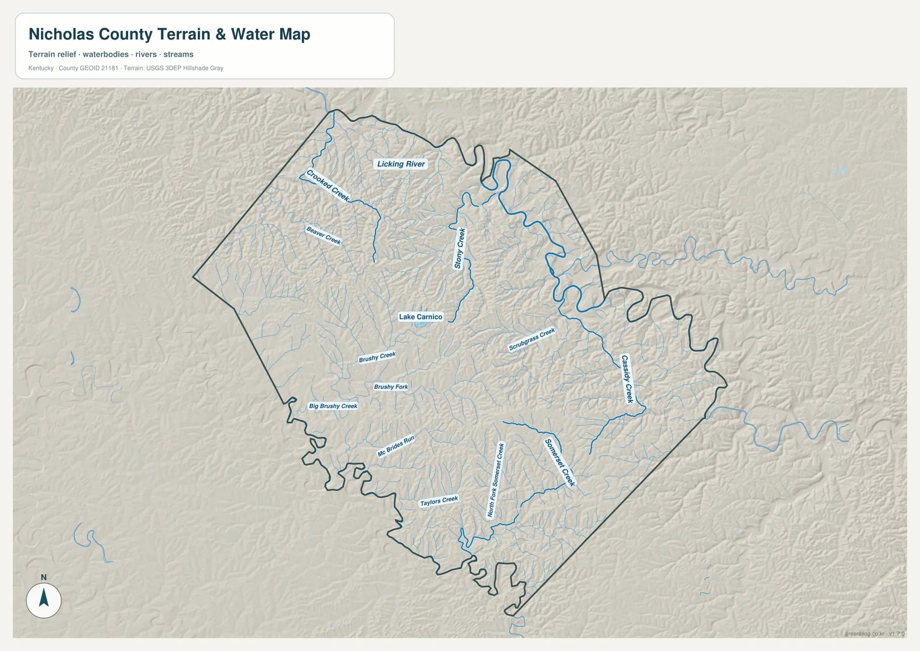
Licking River and Stony Creek frame the northern and central drainage
The Licking River is the dominant water feature on the terrain-and-water map, bending along the northern and northeastern side of the county. Crooked Creek approaches from the northwest, while Beaver Creek occupies a smaller nearby valley. The lower terrain along the river provides a strong contrast with the more tightly ridged interior.
Stony Creek runs through the central-northern county, with Lake Carnico just to its west. Brushy Creek, Brushy Fork, and Big Brushy Creek occupy the western and southwestern hills, while Mc Brides Run and Taylors Creek add smaller drainage references farther south.
Scrubgrass Creek and Cassidy Creek are prominent in the east. In the south and southeast, Somerset Creek and North Fork Somerset Creek form long valleys between repeated ridges. These streams do not cross a broad flat plain; they occupy narrow lower corridors that are easy to match with the elevation map.
A practical reading order is to locate the Licking River first, then Stony Creek and Lake Carnico, followed by Cassidy Creek in the east and the Somerset Creek system in the south. This is a geographic reference rather than a flood, navigation, water-depth, fishing-regulation, or property-access product. Current conditions should be checked with the responsible agencies.
Elevation from 171 to 325 meters separates river lowlands from higher ridges
The elevation map reports an actual county range of about 171 to 325 meters and a mean near 260 meters. The lowest dark-green terrain follows the Licking River and major creek valleys, especially around the river bends in the northeast. Higher yellow, orange, and brown ridges become much more common across the central and southern county.
The northwest is not flat even though several creek valleys create lower corridors. Crooked Creek and Beaver Creek cut through rolling uplands, and the terrain rises quickly away from their channels. That pattern adds useful context to the winding roads around routes 606, 32, and 648.
Central and southern Nicholas County contain some of the largest continuous areas of higher ground. Brushy Fork, Taylors Creek, and Somerset Creek remain in lower valleys, while the intervening ridges rise into darker elevation colors. A similar pattern appears around Cassidy Creek in the east.
The elevation colors are designed for county-scale comparison rather than parcel-level measurement. They are useful for distinguishing river and creek valleys from higher uplands, but they should not be treated as survey-grade elevation for a road, structure, property, or engineering project. Exact site work should rely on current source data or professional surveying.
Following Nicholas County from Carlisle to the river bends and southern creeks
Carlisle is the simplest starting point for comparing all of the map views. On the road map, locate routes 32, 36, and 68, then identify Morning Glory to the northwest and Milltown toward the east. On the water map, the Licking River and Stony Creek provide the first physical references around the central and northern county.
For the west, use routes 648 and 32 together with Crooked Creek and Brushy Creek. Lake Carnico provides an additional water landmark near the center-west. The elevation map shows those valleys as lower corridors between ridges, adding context to the winding local road network.
For the south and east, routes 36, 928, and 57 help divide the county into smaller sections. Cassidy Creek and the Somerset Creek system then provide the water references. The elevation surface shows that these areas contain more continuous high ridge terrain than the Licking River lowlands to the north.
Choosing the best Nicholas County map for print, class, or reference
Use the general county map when Carlisle, Morning Glory, Milltown, East Union, numbered roads, and the full boundary need to appear together. The city-distribution map is cleaner when the main point is that Carlisle is the only ranked major city and that Nicholas County sits among several northeastern Kentucky counties.
Choose the terrain-and-water map for the Licking River, Stony Creek, Cassidy Creek, Somerset Creek, Brushy Creek, and Lake Carnico. The elevation map is the strongest view for explaining the difference between lower river corridors and higher central and southern ridges. Comparing water and elevation together makes the county’s terrain much easier to understand.
The WebP images in the article are optimized for browser viewing. The downloadable ZIP contains the original JPG maps at 3,638×2,572 pixels each, which is better suited to printing, classroom worksheets, presentations, and offline reference. These maps are general geographic resources rather than legal boundary records, flood studies, parcel surveys, navigation products, or engineering plans.
Frequently Asked Questions
Where is Carlisle within Nicholas County?
Carlisle sits near the center of the county and is easy to locate around routes 32, 36, and 68. Kentucky.gov’s official City of Carlisle profile identifies Carlisle as the Nicholas County seat. Its central position makes it the easiest starting point for locating the Licking River, Stony Creek, and the southern ridge country.
Which map best shows the Licking River and Lake Carnico together?
The terrain-and-water map is the best choice. It shows the Licking River, Crooked Creek, Stony Creek, Brushy Creek, Scrubgrass Creek, Cassidy Creek, Somerset Creek, and Lake Carnico in one view.
Can the 171–325 meter elevation range be used as an exact property elevation?
No. The range summarizes the actual countywide elevations shown on the supplied map, with a mean near 260 meters. It is useful for comparing river valleys with higher ridges, but exact site elevations should come from current source data or professional surveying.
Map File Information
The ZIP archive contains the original high-resolution JPG versions of the Nicholas County road-and-boundary map, city-distribution map, terrain-and-water map, and elevation map. Each image is 3,638×2,572 pixels for printing, classroom work, presentations, and offline reference.
- File Type: 4 JPG files inside one ZIP archive
Related Maps
Sources and references
County information is available from the Kentucky.gov Nicholas County profile and the Kentucky.gov City of Carlisle profile. For underlying geographic data, see the U.S. Census Bureau TIGER/Line Shapefiles for boundaries and roads, USGS National Hydrography for rivers, lakes, and streams, and the USGS 3D Elevation Program for elevation data.
These maps are intended for geographic explanation, printing, and general reference. Legal boundary decisions, live traffic, flood and water-safety questions, property surveying, and engineering work should rely on the latest authoritative information from the responsible public agency.
Green Map creates custom-edited map images using open geographic data sources such as geoBoundaries, Natural Earth, OpenStreetMap, and government open data. These maps are edited visual materials, not raw data files, and are provided for education, documents, presentations, and graphic reference.