Jackson County stretches from the Mississippi Sound and a chain of coastal communities far into the inland river country of southeastern Mississippi. Pascagoula and Moss Point sit near the eastern estuary, Gautier and Ocean Springs occupy the western side of the coast, and places such as Vancleave, Wade, and Hurley show how much of the county lies well north of the shoreline. The maps on this page are most useful when read together because the road network, city spacing, waterways, and elevation all change noticeably between the coast and the interior.
The high-resolution JPG versions of the supplied maps are also available as a ZIP download. The WebP images in the article are intended for quick viewing, while the downloadable files are better suited to printing, presentations, and other work that needs a larger image.
Table of Contents
From the Pascagoula coast to the inland communities
The general county map makes the north-south contrast easy to see. Pascagoula, Moss Point, Gautier, and Ocean Springs are concentrated near the southern edge, where roads and waterways are more tightly packed. Vancleave sits farther inland, while Wade and Hurley extend the mapped settlement pattern toward George County. This arrangement is important because a search for Jackson County can otherwise give the impression that the county is mainly the Pascagoula-Ocean Springs coast.
I-10 crosses the county just inland from the coast, while US 90 follows the southern urban belt more closely. MS 57 runs north from the Ocean Springs side toward Vancleave, and MS 63 provides a strong north-south route through the Pascagoula and Moss Point side of the county. MS 613 serves the Escatawpa and Helena area, and the northern roads around Wade and Hurley connect the coastal half of the county with its more rural interior.
How the major coastal cities are spaced from Pascagoula
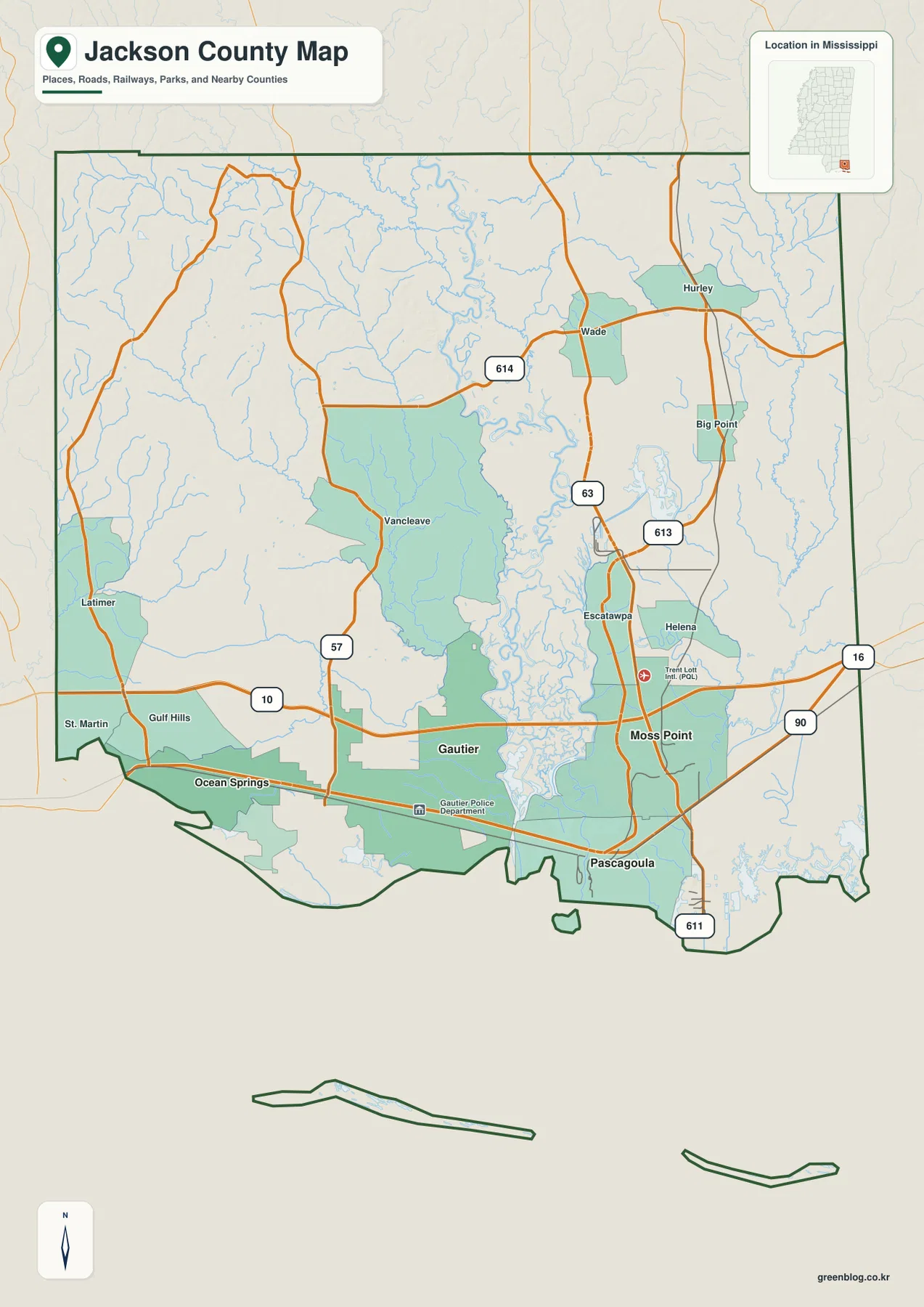
The city-connections map uses Pascagoula as the hub and compares it with three other major cities shown on the map. Gautier is marked 7 miles from Pascagoula, Moss Point 5 miles, and Ocean Springs 14 miles. Those values are straight-line distances rather than driving distances, so they are best used to understand relative spacing and direction. A road trip between the same places may be longer because it must follow bridges, highways, and local streets.
The map labels Pascagoula at 21,710 residents, Gautier at 19,046, Ocean Springs at 18,646, and Moss Point at 11,957. More important than the ranking is the way the four cities occupy different parts of the coast. Ocean Springs is the westernmost of the group, Gautier lies to its east, Pascagoula sits farther southeast, and Moss Point is positioned northeast of Pascagoula near the river system. That pattern helps explain why US 90 is such a useful reference when reading the urban side of the county.
Pascagoula River, estuary channels, and Mississippi Sound
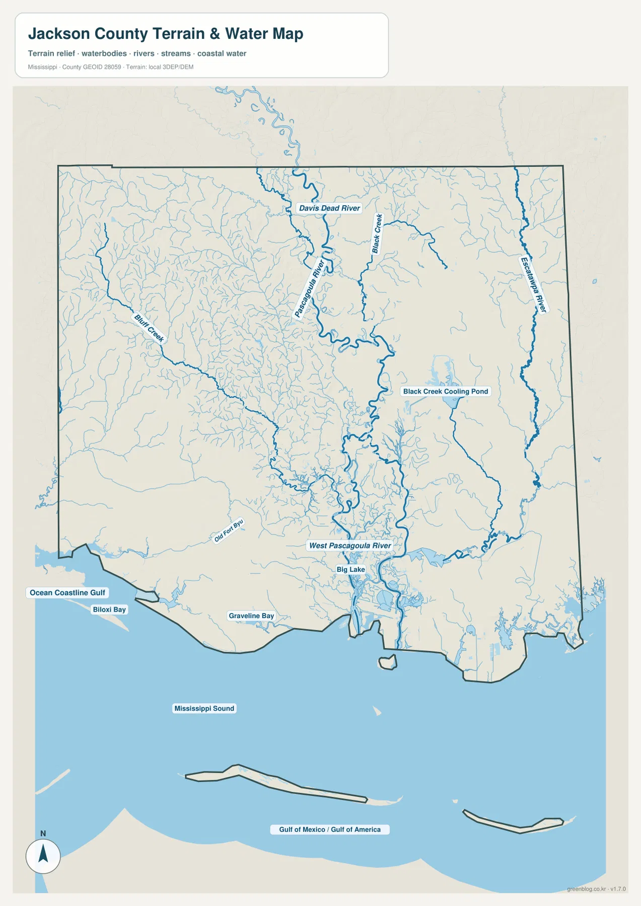
The water map shows why the southern half of Jackson County is difficult to understand from roads alone. The Pascagoula River descends through the east-central county and spreads into a broad network of channels before reaching the coast. West Pascagoula River is labeled near the lower estuary, while Escatawpa River marks the eastern side. Farther north, Davis Dead River and Black Creek are identified, and Bluff Creek crosses the western interior.
Closer to the shoreline, the map labels Big Lake, Old Fort Bayou, Graveline Bay, and Biloxi Bay before opening into Mississippi Sound. The number of branching channels around the lower Pascagoula River is one of the clearest visual features of the county. This is a location-reference map, not a flood-hazard, navigation, parcel, or legal-water-boundary product, so specialized decisions should use the appropriate official source instead.
A very low coast with higher ground in the interior
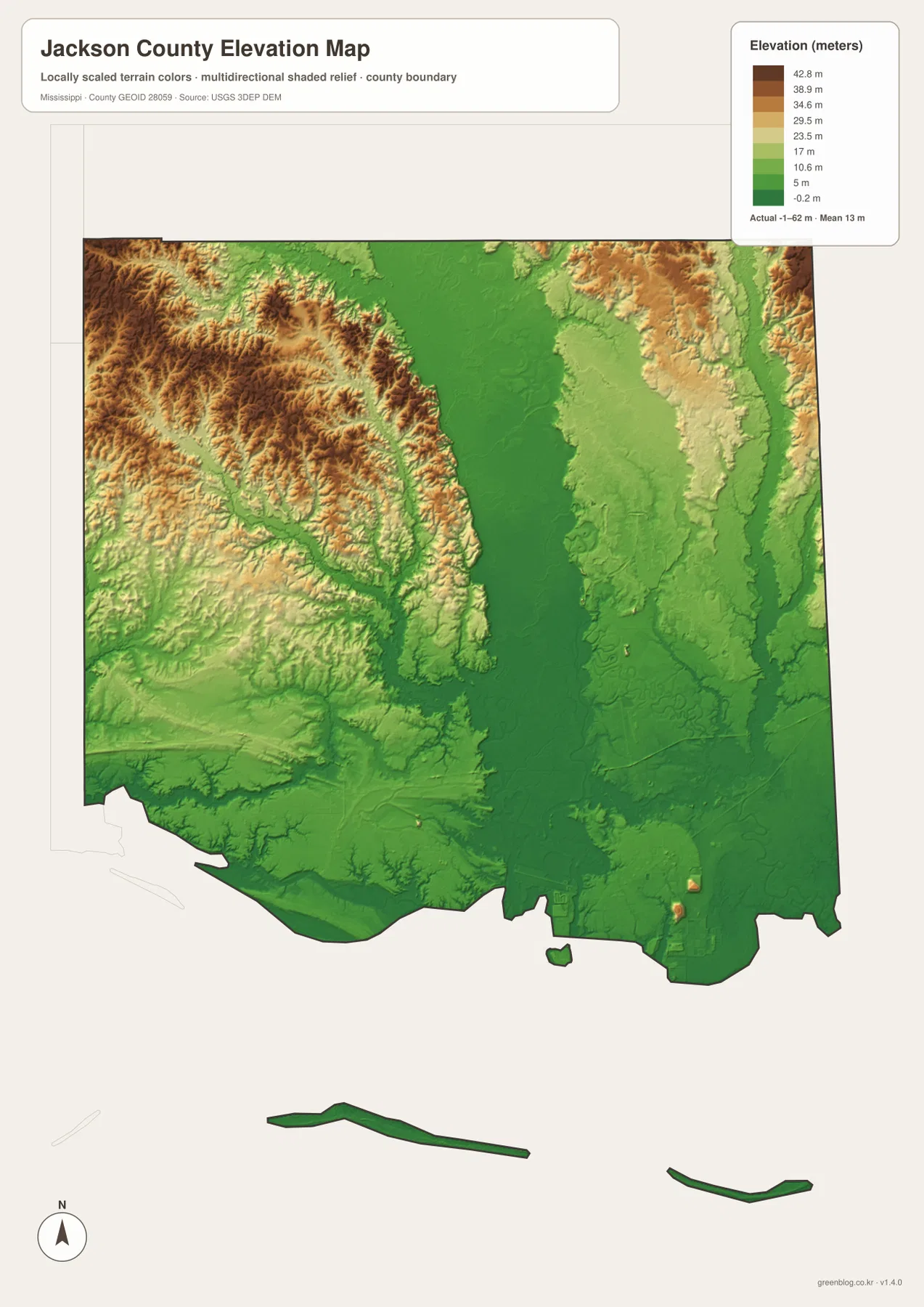
The elevation map reports an actual county range of about -1 to 62 meters and a mean of about 13 meters. The coast and the lower Pascagoula River corridor are shown in the lowest green tones, and a broad low area continues north along the main river system. Higher terrain appears most clearly in the northwest, with additional elevated ground in parts of the northeast. The result is a county where relatively modest elevations still create a strong visual contrast because the coast and estuary are so low.
Ocean Springs, Gautier, Pascagoula, and Moss Point all lie within the generally low southern section. Moving inland, the terrain becomes more textured, with small ridges and valleys becoming easier to see. The elevation surface is generalized for county-scale reference, so it is useful for comparing broad terrain but not for site surveying, engineering grades, or construction decisions.
Roads and neighboring counties help orient the map
Harrison County lies to the west, Stone County to the northwest, and George County to the north, while the eastern edge of Jackson County reaches the Alabama side. Ocean Springs is therefore close to the Harrison County side of the map, Wade and Hurley sit nearer the George County direction, and Pascagoula and Moss Point anchor the southeast. Reading these positions together makes the county boundary easier to understand than treating each city as an isolated point.
I-10 works well as the main east-west inland reference, whereas US 90 is more useful for following the sequence of coastal cities. MS 57 helps connect the Ocean Springs side with Vancleave, and MS 63 provides a north-south path through the Pascagoula-Moss Point side. These route relationships also explain why the densest road pattern appears in the south even though the county extends a considerable distance inland.
Key facts to keep beside the maps
| Item | Jackson County reference |
|---|---|
| County seat | Pascagoula |
| 2020 census population | 143,252 |
| July 2025 population estimate | 147,666 |
| 2025 Gazetteer land area | 722.825 sq mi |
| 2025 Gazetteer water area | 320.578 sq mi |
| Useful route references | I-10, US 90, MS 57, MS 63, MS 613 |
| Elevation-map range | About -1 to 62 m; mean 13 m |
The 2020 census count and July 2025 estimate refer to different dates and should not be treated as the same measurement. The Gazetteer also separates land and water area. In Jackson County, the large water figure is especially relevant when looking at the Mississippi Sound, bays, estuary channels, and offshore portions of the county boundary shown on the supplied maps.
If you need the original map files rather than the page previews, the ZIP below contains the high-resolution JPG versions of the county map, city-connections map, water map, and elevation map.
Frequently Asked Questions
Are the distances from Pascagoula driving distances?
No. The city-connections map uses straight-line distances. It marks Gautier at 7 miles, Moss Point at 5 miles, and Ocean Springs at 14 miles from Pascagoula, while actual road distances can vary.
Is all of Jackson County nearly at sea level?
The coast and lower river areas are very low, but the interior is not uniform. The supplied elevation map shows an actual range of about -1 to 62 meters, with noticeably higher terrain in parts of the northwest and northeast.
Can the water map be used as a flood-zone map?
No. It is designed to show the location of rivers, bays, lakes, channels, and coastal water. Flood insurance, permitting, or property decisions should use the appropriate official flood-hazard information.
Map File Information
The ZIP contains high-resolution JPG versions of the Jackson County reference maps for printing, presentations, and other large-image uses.
- Included Files: county map, city-connections map, water map, elevation map
- File Type: JPG
Related Maps
Sources and References
- U.S. Census Bureau Jackson County QuickFacts
- Mississippi Department of Transportation official highway map
- USGS National Hydrography
- USGS 3D Elevation Program
- National Park Service Gulf Islands National Seashore
Green Map creates custom-edited map images using open geographic data sources such as geoBoundaries, Natural Earth, OpenStreetMap, and government open data. These maps are edited visual materials, not raw data files, and are provided for education, documents, presentations, and graphic reference.