Union County lies in southwest Iowa, where Creston is the clearest place to begin a county-wide view. This Union County Iowa Map page brings together roads, communities, lakes, streams, and elevation so those features can be compared rather than studied in isolation. The images in the article are lightweight WebP previews for quick viewing, while the download box near the end provides the same county, city, water-and-terrain, and elevation maps as full-resolution JPG files.
Creston occupies the western half of the county and stands out as the largest community on the map. Afton lies farther east, Lorimor is near the northeastern corner, and Arispe and Shannon City help define the southern part of the county. Roads labeled US 34, Iowa 25, and US 169 give immediate orientation, while the terrain maps add a second layer of geography. Green Valley Lake and the Platte River system shape the western side, Lake Afton and Twelve Mile Creek help organize the middle, and the Thompson River marks a prominent lower corridor on the east.
Table of Contents
Using Creston and US 34 as the first reference points
The county reference map is the best place to see settlements, roads, rail lines, parks, streams, and the county boundary in one frame. Creston is easy to locate because its street network is denser than the surrounding rural roads and because several prominent routes meet nearby. US 34 enters from the west and runs through the Creston area before continuing across the county, while Iowa 25 provides a strong north-south reference near the city. Once those anchors are found, Cromwell can be placed near the western edge, Afton to the east, and Arispe farther south near US 169.
Creston is also the county seat. Union County’s official history explains that the city developed around the railroad and that the county seat moved from Afton to Creston in 1890. That history is visible in the modern map in a practical way: the road and rail network around Creston is much denser than around the smaller towns. Afton remains an important eastern reference point, so the distance between Creston and Afton provides a useful sense of the county’s width and of how its two best-known communities relate to the rural landscape between them.
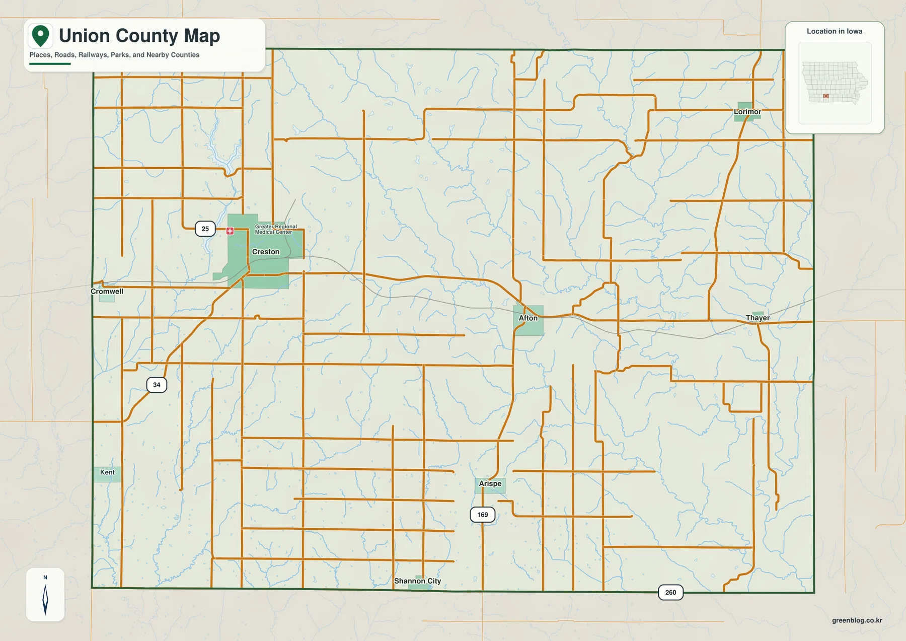
The eastern half of the map has a different appearance. Afton sits near the middle-east, with local roads spreading into the surrounding farm country. Lorimor is well to the northeast, while Shannon City lies close to the southern edge. Thayer appears near the eastern side and gives another useful landmark when comparing the detailed map with the water map. The towns are not arranged along one straight corridor. Instead, the settlement pattern is dispersed, with Creston forming a strong western center and several smaller communities occupying separate parts of the county.
This map should be read as a static geographic reference rather than a navigation service. It is excellent for understanding where a town sits relative to a numbered highway, railway, stream, park, or county edge, but it does not provide live closures or turn-by-turn routing. For a report, classroom handout, printed reference, or general county overview, the combination of detailed roads and labeled places is an advantage. A simple approach is to begin with Creston or Afton, identify the nearest numbered route, and then follow the smaller roads to the location of interest.
A city pattern stretching from Creston to Lorimor and the southern towns
The city distribution map removes much of the road detail and highlights six communities: Creston, Afton, Lorimor, Shannon City, Cromwell, and Arispe. The printed ranking places Creston first by a wide margin and Afton second. Lorimor marks the northeast, Shannon City and Arispe mark the south, and Cromwell sits near the western boundary. Because the map is intentionally uncluttered, it is easier to compare spacing than on the reference map. The six labels show immediately that most of the county remains rural between relatively small urban points.
Creston and Afton have a particularly useful historical relationship. Afton served as the early county seat after its founding in the 1850s, while Creston grew rapidly with the railroad and became the permanent county seat in 1890. Today they still work as the two strongest place names for orienting a reader across Union County. On the city map, Creston occupies the west-central area and Afton stands farther east. The separation between them helps explain why many local roads and smaller waterways are important to rural travel rather than everything radiating from one central city.
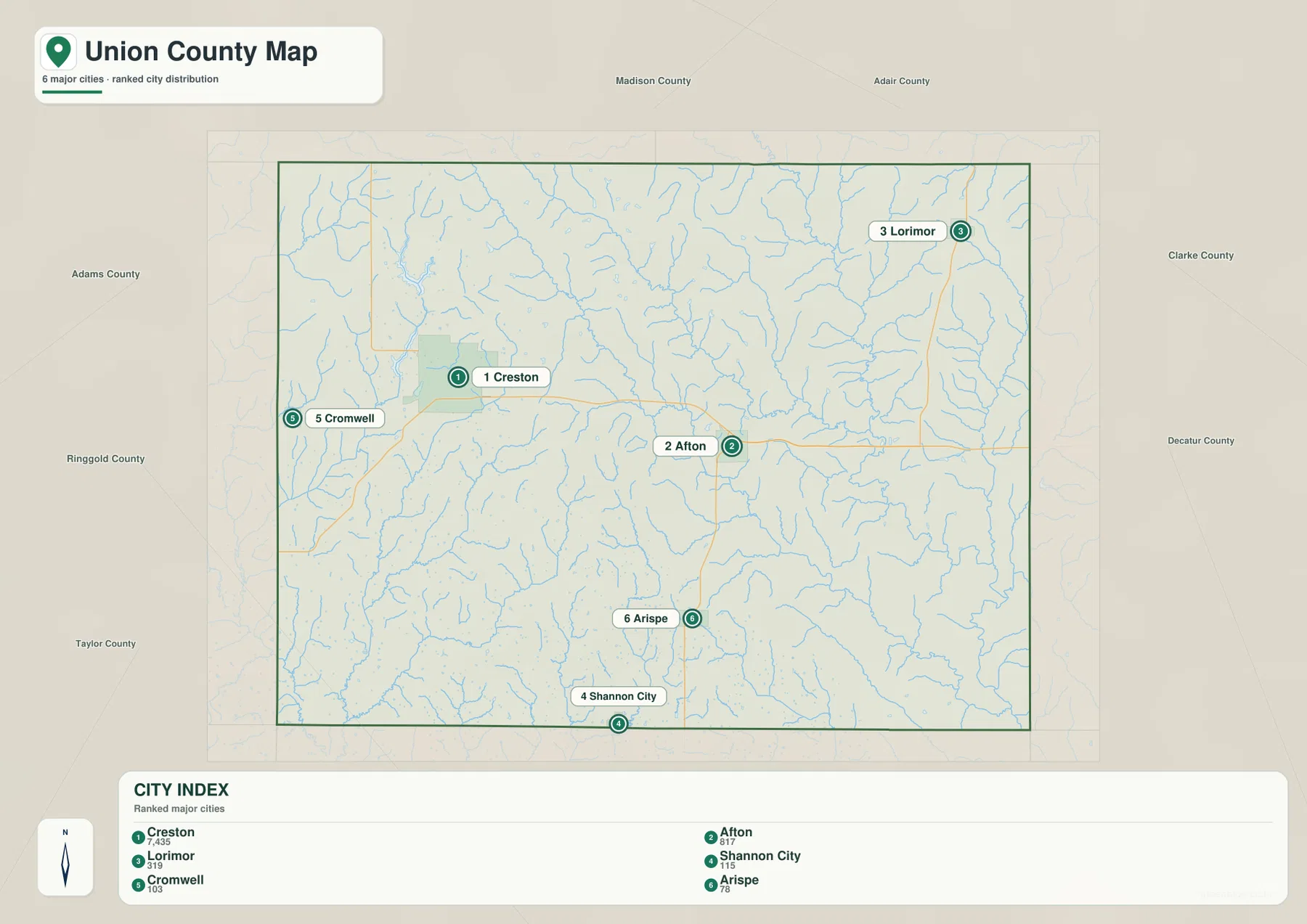
The population numbers printed in the map index are best treated as part of this map set, not as replacements for the latest Census or official estimates. Different sources may use different reference years. The spatial pattern is the more durable value: Creston is clearly the dominant city, Afton is the main eastern town, and the remaining places are spread across distinct parts of the county. That layout is useful when deciding which town to use as an anchor for a nearby lake, stream, road, or recreational area.
Lorimor is especially helpful for locating the northeastern corner because it is far from Creston and Afton. Arispe sits south of Afton and is easy to relate to US 169 on the detailed map. Shannon City is farther south, while Cromwell helps define the western side near Creston. Learning those six locations first makes the physical maps easier to interpret. Green Valley Lake can then be connected with the Creston area, Lake Afton with Afton, and the eastern water features with places closer to the Thompson River corridor.
Green Valley Lake and the Platte River network west of Afton
The water-and-terrain map gives the western half of Union County a very different emphasis from the road map. Green Valley Lake is a prominent elongated water body just north of Creston, while Summit Lake and Lake McKinley add smaller lake features nearby. The Platte River system is the major stream framework on this side of the county. The map labels the Platte River, Middle Platte River, and East Branch Platte River, along with many unnamed or smaller tributaries that descend from the surrounding uplands into those larger channels.
Green Valley Lake is also tied to one of the county’s best-known recreation areas. The Iowa Department of Natural Resources identifies Green Valley State Park in Union County as a destination for fishing, boating, camping, picnicking, and hiking. The agency notes that Green Valley Lake is part of a cluster of lakes in southwest Iowa that also includes Three Mile Lake, Twelve Mile Lake, and Summit Lake. The county-scale map is not a park trail map, but it is very useful for showing where Green Valley Lake sits in relation to Creston and the wider drainage network.
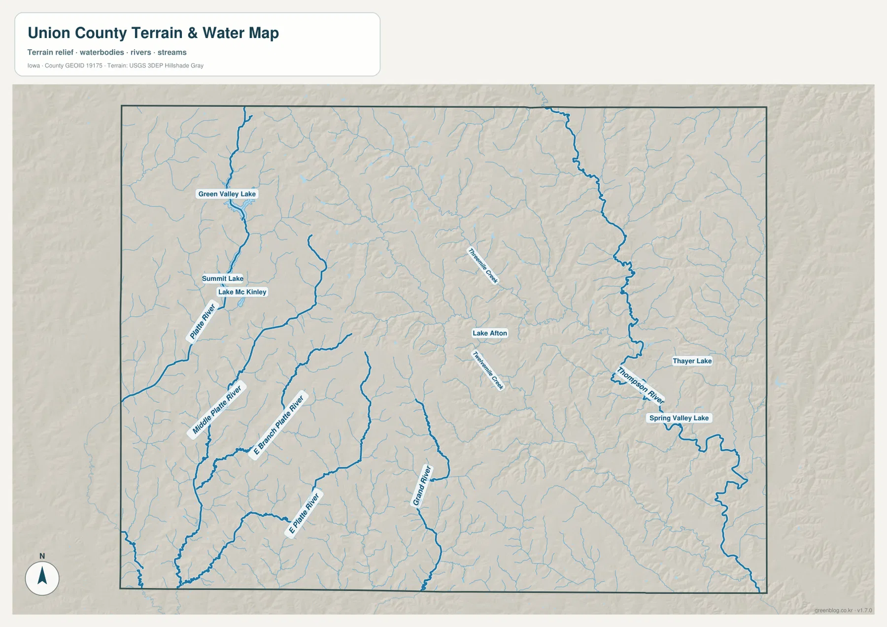
The western waterways also explain the texture of the land around Creston. Green Valley Lake occupies a lower corridor north of the city, and the branches of the Platte River cut through higher ground to the west and southwest. Summit Lake and Lake McKinley provide additional points of reference in that same broad area. When the water map is compared with the city map, Creston no longer appears to sit in an empty grid of roads. It becomes part of a rolling landscape in which valleys, reservoirs, and tributaries break the uplands into many smaller ridges.
This map is meant to explain the location of water features and broad terrain, not flood risk, water quality, lake access rules, or current stream conditions. Floodplain decisions require specialized official products, and recreation questions should be checked against current Iowa DNR or local information. For general geography, however, the water map provides something the road map cannot: it shows the directions in which small streams gather into larger valleys and makes the connection between Creston, Green Valley Lake, and the Platte River system easy to see.
Lake Afton, Twelve Mile Creek, and the Thompson River on the eastern side
The middle and eastern parts of Union County are organized around a different set of water features. Lake Afton sits near the Afton area and provides an obvious central landmark. Twelve Mile Creek runs across part of the central county and is joined by smaller tributaries. Farther east, the Thompson River forms one of the strongest blue channels on the map and occupies a broad low corridor near the county’s eastern side. The contrast with the Platte River network makes it clear that Union County is divided among several branching drainage systems rather than one dominant river.
Thayer Lake and Spring Valley Lake add smaller eastern water bodies, while the tributaries around Lorimor and Afton form a dense web of narrow valleys. These features matter for orientation because local descriptions often refer to a creek, lake, or valley rather than a highway. A reader who first learns the city pattern can use the water map to place Lake Afton near Afton, Green Valley Lake near Creston, and the Thompson River farther east. That is often faster than trying to interpret the entire network of minor roads and streams at the same time.
Afton is especially useful as a bridge between the settlement and physical geography. On the city map it is the second highlighted community and stands well east of Creston. On the water map, Lake Afton and nearby tributaries make the same area recognizable even without city labels. Switching between the two views shows how roads cross the valleys and how settlements occupy the higher ground between streams. This kind of comparison is useful in county reports because it connects human geography with the terrain instead of treating the towns and waterways as unrelated layers.
The named lakes should not be interpreted as complete recreation maps. Boat ramps, trails, campgrounds, park boundaries, and private-property lines are not the purpose of this county-wide water image. Green Valley State Park has its own official materials, and other sites may be managed by local or state agencies with more detailed information. The value of this map is scale: it makes the entire county visible at once and shows how the lakes and streams fit between Creston, Afton, Lorimor, and the surrounding rural roads.
From higher western uplands to lower eastern valleys at 288–415 meters
The elevation map supplies the clearest view of Union County’s rolling relief. Its legend reports an actual mapped range of about 288 to 415 meters and a mean near 369 meters. Brown shades represent the higher parts of the county, while greens mark lower ground. The western side is dominated by warmer colors and closely spaced ridges, whereas large green valleys become more prominent toward the east. The change is not a simple smooth slope, because streams repeatedly cut narrow lower corridors into the higher uplands.
The relationship with the water map is easy to see. Lower bands in the west follow the Platte River and its branches. In the center, Twelve Mile Creek and smaller channels create additional green corridors, and the Thompson River forms an especially broad low zone on the eastern side. Higher land fills the spaces between these valleys. The resulting pattern looks strongly dissected: many short ridges and slopes are separated by stream channels, creating the rolling terrain that characterizes much of southwest Iowa.
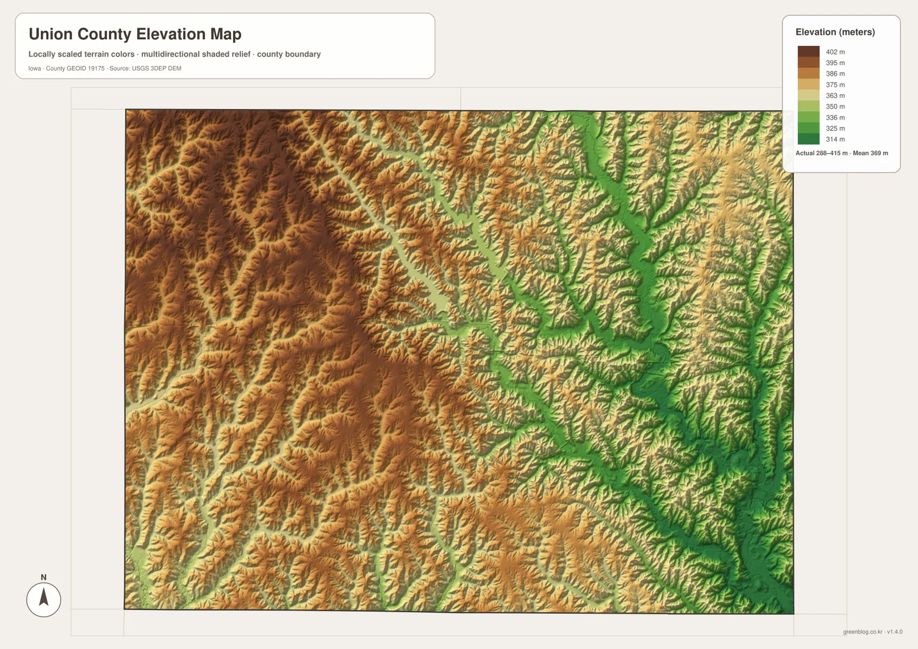
This terrain pattern changes how the places on the road map should be understood. Creston is surrounded by rolling uplands but lies close to the Green Valley and Platte drainage features. Afton occupies the middle-east, where tributaries become increasingly connected with lower eastern valleys. Lorimor in the northeast also sits among numerous stream-cut ridges rather than on a broad flat surface. The map does not show city labels, so it works best when compared with the county or city map rather than used alone for locating a town.
The elevation surface is intended for regional comparison, not site surveying. A county-wide range of 288–415 meters is useful for explaining why the west looks higher and why the Thompson River valley appears low, but it cannot provide the certified elevation of a house, parcel corner, bridge, or construction site. Engineering and legal work should use the underlying USGS elevation data or professional survey information. For a general geography page, the map’s main strength is showing how closely the streams and valleys are tied to the county’s rolling relief.
Choosing the best map and downloading the full-resolution set
Choose the reference map when the main question involves a town, road, railway, county edge, or general orientation. Creston, Afton, US 34, Iowa 25, and US 169 provide strong starting points, while smaller road and stream labels add local detail. Choose the city map when the goal is to compare the highlighted communities without the distraction of many rural roads. It makes the large gap between Creston and Lorimor obvious and shows how Afton, Arispe, Shannon City, and Cromwell fill different parts of the county.
For physical geography, the water and elevation maps work best as a pair. Green Valley Lake and the Platte branches can be located first on the water map and then followed into the lower bands on the elevation surface. The same method works in the east with the Thompson River and Spring Valley Lake. This side-by-side comparison is useful for classroom work, regional reports, recreation orientation, or anyone trying to understand why the county’s streams follow certain corridors through the hills.
The full-resolution files are helpful when small labels matter. The reference and water maps contain many local names that are easier to read on a large screen or full-page print. The elevation map depends on color gradients and shaded relief, so a color display or color printer preserves more detail than grayscale output. The city map is simpler and remains readable at smaller sizes. The archive below contains all four 3638 × 2572 pixel JPG originals together for close viewing and printing.
Frequently Asked Questions
What is the easiest place to use as a starting point on a Union County map?
Creston is the most useful starting point because it is the county seat, the largest highlighted city, and a major road and rail center. US 34 and Iowa 25 provide easy orientation near the city. From Creston, Afton lies to the east, Lorimor to the northeast, Arispe and Shannon City to the south, and Cromwell near the western edge. Green Valley Lake is also close to Creston, so the city connects the road, settlement, and water maps particularly well.
Are Green Valley Lake and Lake Afton in the same part of Union County?
No. Green Valley Lake lies close to Creston in the western half of the county, while Lake Afton is farther east near Afton. Comparing the two on the water map helps separate the Platte River drainage in the west from the central and eastern tributaries. For recreation details such as trails, campgrounds, boat ramps, or current park notices, use the official Iowa DNR materials for Green Valley State Park and the appropriate local source for other lakes.
Can the 288–415 meter elevation range be used for an exact property elevation?
No. The range is a county-wide summary for understanding broad relief, such as the higher western uplands and lower Thompson River valley. It is not a parcel survey or a certified point elevation. Construction, drainage design, engineering, or boundary work should rely on the underlying USGS elevation data and, when required, professional surveying. The map is best used to compare valleys and uplands at the regional scale.
Map File Information
The download contains the Union County reference map, city distribution map, water-and-terrain map, and elevation map as full-resolution JPG files. They are better suited to close inspection and printing than the lightweight WebP previews used in the article.
- Included Files: Union County reference map, city map, water and terrain map, and elevation map
- Printable Size: 3638 × 2572 px for each JPG
Related Maps
Sources and References
The county descriptions are based on the supplied map previews together with official Union County and Iowa DNR information. Federal mapping references are included below for the types of boundary, hydrography, and elevation data used in county-scale mapping.
- Union County, Iowa official website – county offices, courthouse, communities, and local overview
- Union County – Creston – official history of Creston and the county-seat move from Afton
- Iowa DNR Green Valley State Park – official information for Green Valley Lake, recreation, and park facilities
- U.S. Census Bureau TIGER/Line Shapefiles – county boundary, road, and place-reference data
- USGS National Hydrography – national hydrography and water-feature data
- USGS 3D Elevation Program – national elevation and terrain data
Green Map creates custom-edited map images using open geographic data sources such as geoBoundaries, Natural Earth, OpenStreetMap, and government open data.
These maps are edited visual materials, not raw data files, and are provided for education, documents, presentations, and graphic reference.